|
REFINE
Browse All : Separate Map from American Revolution
1-14 of 14
Author
[Aitken, Robert, Simitiere, Pierre]
Full Title
Map of the Maritime Parts of Virginia Exhibiting the Seat of War and of Ld. Dunmore's depredations in that Colony.
List No
15852.000
Author
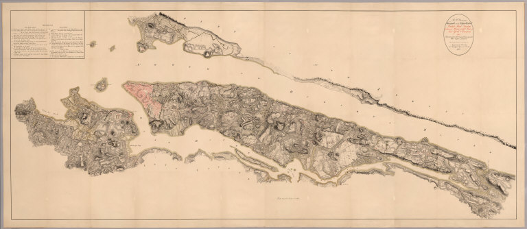
Des Barres, Joseph F. W.
Full Title
Halifax Harbour. Survey'd & publish'd according to Act of Parliament by J.F.W. Des Barres Esqr., Jany. 30, 1779.
List No
13084.000
Note
Uncolored Nautical chart, with hand colored inset views of Entrance to Halifax Harbor. Bathymetry shown by soundings. Relief shown by shading. Prime meridian is Greenwich. Text block provides sailing directions. Originally issued in 3 sheets. In upper right: Pl. 20. In: Des Barres, Joseph F.W. The Atlantic Neptune, published for the use of the Royal Navy of Great Britain. London, 1774-1781. Vol. 1, p. 30. Notes on the map from Alexander Johnson: "This is one of the finest and most important sea charts in both the history of Canada and the American Revolutionary War era. It is a gargantuan map of Halifax Harbour, the North American headquarters of Britain’s Royal Navy, printed during the height of the American Revolutionary War (1775-83). It is based upon the mapping of the eccentric genius J.F.W. Des Barres, a Swiss-born cartographer who conducted advanced trigonometric surveys of all of the coasts of Peninsular Nova Scotia between 1764 and 1770, of which his charting of Halifax Harbour was his signature achievement. The present chart, printed on three enormous copper plates, was beautifully designed and printed under Des Barres’ direct supervision as part of his epic sea atlas of North American waters, The Atlantic Neptune (printed in various collations and formats, London, 1777-84). Des Barres charts are peerless works in that they are both scientifically accurate, yet also highly decorative, embellished with the technically demanding technique of aquatint and magnificent artistic flourishes, such as large profile views. Des Barres chart of Halifax Harbour is one of his largest and most artistically virtuous works, in addition to its value as the era’s finest navigational aid to the one of the continent’s key ports. The main chart embraces all of Halifax Harbour, taken from a roughly westward orientated perspective, including the Bedford Basin, the Narrows, the North West Arm and the adjacent havens of Sambro Harbour, Catch Harbour and Rocky Inlet. The city of Halifax (shaded in red) appears in the centre-right, with the grid of its streets, numerous fortifications and the ‘Dock Yard’, the all-important facility that was the epicentre of the Royal Navy’s operations in the western Atlantic. Copious bathymetric soundings dot the harbour floor, extending well out into the open sea, while the coastlines are precisely delineated, making this by far the most accurate (and the largest) sea chart of Halifax Harbour made during the 18th Century. The land area is printed by the lovely, frosty aquatint method, one of the most elegant, yet technically demanding, printing methods, usually reserved for fine art pieces and seldom employed for maps. On the lower-right side of the map is a large roundel containing detailed sailing directions for navigating the harbour, while above and to the right, is a beautiful view of the Sambro Island Lighthouse, which marks the gateway to the harbour and, constructed in 1759, still survives to this day, making it the oldest operational lighthouse in North America. The large register that makes up the lower part of the composition features a profile view of the entrance of the harbour from the vantage point of just off Chebucto Head. The scene of varied topography is shown teeming with tall ships and bathed in gorgeous original wash colours. Des Barres had the unusual habit of continually modifying his plates as he published his works, resulting in many of his charts appearing in numerous states and variants, many of which are seemingly unrecorded. His chart of Halifax Harbour, one of his most important works, was impatiently demanded by the Admiralty Board, and so was first issued bearing the imprint date of ‘January 30, 1776’, and placed within the first volume of The Atlantic Neptune. The Henry Newton Stevens Collection, at the National Maritime Museum (Greenwich), the most comprehensive assemblage of Des Barres charts, records 11 states and variants of the chart. Des Barres added some additional details to his 1776 versions, reissuing the chart with the imprint date of ‘January 30, 1779’, as evident on the present example. While not precisely the same, the present example of the chart bears some similarities to both the Stevens Collection Variants ‘45F’ and ‘45F*’. A third, and final, revision of the chart was issued bearing the date ‘January 30, 1781’. Des Barres’ chart was the ultimate authority for navigating Halifax Harbour for many years and served as the basis for the work of many other mapmakers. Halifax: Epicentre of the Royal Navy during Three Great American Wars Halifax is considered by professional mariners to possess one of the finest natural harbours in the world. Not only is it large (the Bedford Basin can easily host even the greatest flotilla), it is deep, free of major obstacles, entirely protects vessels from oceanic swells, and is close to the main Trans-Atlantic shipping lanes. In 1749, the British founded the purpose-built city of Halifax to act a counterweight to the French fortress of Louisburg, on nearby Cape Breton Island. Halifax was soon selected as the capital of Nova Scotia, and upon the reduction of Louisburg in 1758, it became the Headquarters of the Royal Navy’s North American Squadron. For the remainder of the Seven Years’ War (1756-63), Halifax played a central role in the conflict, outfitting victorious military expeditions to Canada and the West Indies. The city grew rapidly, and the Naval Dock Yard became the finest and best equipped in the Americas. During the American Revolutionary War (1775-83), Nova Scotia remained loyal to the empire, and Halifax was the staging ground for most of the major naval expeditions in the conflict, including the successful British invasion of New York (1776), the largest such undertaking in the history of the Americas. While, as we all know, the overall war was not a success for Britain, Halifax prospered, as vast resources flowed into the city, including prize money won by privateers who preyed upon American shipping. Meanwhile, Loyalist refugees swelled its population. While many of the Loyalists were almost destitute and initially required assistance, some were amongst New England’s wealthiest grandees, individuals who became pillars of business and government in post-war Nova Scotia. Throughout the war, Des Barres’ chart would have been an indispensable aid for navigation, and many copies are recorded as having been shipped from Des Barres’s London workshop to Halifax, via Portsmouth. Halifax remained the headquarters of the Royal Navy’s North American Squadron through the War of 1812 (1812-4), when British naval vessels and privateers enjoyed great success against the Americans, adding further wealth to the city. However, a bit of the bloom came off the rose in 1818, when Halifax was compelled to share its status with Bermuda; Halifax henceforth served as the ‘Summer HQ’ of the Navy, while Bermuda acted s the ‘Winter HQ’ (evidently the Admirals did not like Nova Scotian winters!). Nevertheless, Halifax remained a major port of commerce and military affairs, a status it enjoys to this day. J.F.W. Des Barres & The Atlantic Neptune Joseph Frederick Wallet Des Barres (1721 – 1824) was a larger-than-life figure who had a transformative impact upon the Canadian Maritimes. He was born in Basel, Switzerland, and studied mathematics at that city’s university under the famous Bernoulli brothers, Jean and Daniel. An ambitious and adventurous spirit, who saw few opportunities in his staid native land, he immigrated to Britain. There he continued his studies at the newly founded Royal Military Academy at Woolwich, where he was trained in surveying. In 1756, he enlisted in the Royal American Regiment, which was largely composed of well-educated Continental European soldiers, and left for Canada to fight in the Seven Years’ War (1756-63). While in Canada, Des Barres participated in the Siege of Louisbourg (1758) and the Battle of the Plains of Abraham (1759), where the British took Quebec City. In 1760, he was deployed to Halifax to plan the enlargement of the city’s defences and naval yard. In 1762, he worked on surveys in Newfoundland with the young James Cook, the legendary future Pacific explorer. Following the end of the war, Britain was left in possession of virtually all Eastern North America. Very little of this vast empire had been mapped, either hydrographically or topographically, and Whitehall aimed to remedy the situation. In 1764, the Board of Trade organized the General Survey of British North America, which aimed to map the coastal areas of the Atlantic Seaboard by systematic scientific standards. Samuel Holland was charged with mapping the northern regions (Atlantic Canada and New England) and William Gerard de Brahm was tasked with mapping Florida. Peninsular Nova Scotia was excluded for this remit, owing to its unique circumstance as being home to Halifax, the headquarters of the Royal Navy in North America. The Admiralty would thus be tasked with mapping Peninsular Nova Scotia. In 1764, Des Barres was appointed as the Admiralty surveyor for Peninsular Nova Scotia. He was commissioned with making a systematic trigonometric survey of the entire coastline of the peninsula. While geographically a small region, this was a Herculean task, as the coastlines were amongst the most indented and complicated in the world, often beset by fog and storms. From 1764 to 1770, Des Barres led his teams, often against great hardship and danger, to produce a series of remarkably precise sea charts, that when combined would form the first scientific general map of the coasts of Peninsular Nova Scotia. Important to the present work, Des Barres and his men also took the time to sketch the landscape they encountered, creating many of the finest and most historically important 18th Century images of Nova Scotia. In 1770, Des Barres moved to London, where he was charged by the Admiralty with creating the first sea atlas of the British American colonies, The Atlantic Neptune. This would prove to be no ordinary project, as, in good part, due to Des Barres’ eccentricity, perfectionism and workaholism, it turned out to be perhaps the largest and one of the most artistically virtuous cartographic publishing projects ever undertaken. Des Barres not only employed his own charts but was given access to the best manuscripts charts in the Admiralty and Board of Trade archives, by the likes of Holland, Cook, De Brahm and others, creating a work of unrivalled scope and quality. The atlases’ essence was best captured by a contemporary French journal, which described The Atlantic Neptune as “one of the most remarkable products of human industry that had ever been given the world through the arts of printing and engraving”. Printed progressively over a span of a decade, from 1774 to 1784, at its largest extent it comprised five volumes including 115 maps and 146 views, many of which folded out to a massive size. The atlases’ coverage extended all the way down the Atlantic Seaboard and along the Gulf of Mexico, and the lower Mississippi Valley, plus the addition of charts of key harbours in Jamaica. Importantly, the atlases’ volumes did not have set collations, as they were custom ordered, so varied in size and content. The Atlantic Neptune assumed added importance upon the advent of the American Revolutionary War (1775-83), whereby Royal Navy commanders were in desperate need of working charts of North American harbours. It is thus striking that, under such stressful circumstances, Des Barres took the time to create charts and views of an utterly unique artistic élan. Titles were often formed by the most exquisite rococo typography, while many of the charts feature the beautiful medium of aquatint, most unusual in cartography. The views, such as the present work, but were likewise executed in the most virtuous aquatint, sometimes with lavish hand colour. This is remarkable, as the demanding aquatint medium had been introduced to Britain only very recently, making De Barres a pioneer. In both a quest for perfection and through a sense of urgency, Des Barres produced many of this charts and views in numerous states. It is remarkable that while admirals were pressuring Des Barres to finish charts of key harbours, such as Halifax, Boston, Newport and New York, he still stubbornly laboured over the decorative elements of the Neptune. While these actions may have frustrated flag officers, we are today the beneficiaries of his artistic talent and dedication. As for Des Barres, he returned to Canada in 1784, where he served variously as the Lieutenant Governor of Prince Edward Island and Cape Breton Island. Amazingly, he remained daily active, in perfect health, until he passed away at the age of 102! References: Cf. [Citing Similar Variants of the Chart:] Cf. National Maritime Museum (Greenwich): HNS45F and HNS45F*; Stephen J. Hornsby, Surveyors of Empire: Samuel Holland, J.F.W. Des Barres and the Making of The Atlantic Neptune (Montreal, 2011), note reference to chart p. 220; Rodney Shirley, Maps in the Atlases of the British Library, vol. 2, M.DES-1c, no. 20 and M.DES-1f, no. 22; For an overview of British coastal surveying in North America during the era in question, see: Alexander Johnson, The First Mapping of America: The General Survey of British North America, 1765 – 1775 (London: I.B. Tauris, 2017)."
Author
[Great Britain. War Office, Stevens, Benjamin Franklin]
Full Title
(Composite of) B.F. Steven's Facsimile of the Unpublished British Head Quarters Coloured Manuscript map of New York & Environs, 1782, Reproduced from the original drawing in the War Office, London. Issued only to subscribers at 4, Trafalgar Square, W.C., London. 1900. Malby and Sons. Engravers.
List No
6403.004
Note
(Composite removing linen gaps between sections). From the printed advertisement for the map: "BF STEVENS'S Facsimile of the Unpublished British Headquarters Coloured Manuscript Map of New York and Environs 1782. Reproduced from the Original Drawing in the War Office London. 24 sheets Scale 6 1/2 inches to a mile. 10 feet by 4 feet. The successive British Commanders in Chief in America Generals Sir William Howe, Sir Henry Clinton, and Sir Guy Carleton during their respective occupations of New York and Environs in the Revolution caused this manuscript plan from time to time to be kept up. The plan extends from below Guanas Bay to the Heights of Spikendevi, a distance of about eighteen or nineteen miles. It shows the Fortifications, Defenses, Topography, Streets, Roads, etc. of the whole of the Island of New York with the Harbor Islands, Water Ways, and River Frontages on the Hudson and East Rivers, the Military Works on Long Island including Brooklyn, the Works in Paulus Hook and parts of the Jersey Shore. It has a copious Table of References to various works British and American, some of them with notes as to the time of their construction or destruction. The Original Drawing, ten feet by four feet, is on a scale of about six and a half inches to a mile. It is handsomely reproduced for subscribers only in careful facsimile on 24 sheets which can be joined up and mounted like the original as a Wall Map or mounted on linen if desired. It will be issued either mounted on linen to fold in book form with leather slip case 13 x 10 inches or the 24 sheets 22 x 15 inches, each will be supplied in a portfolio. No more than 100 copies are being printed and the engravings are erased as each sheet is printed off. A few extra copies of sheet 8 have been printed so that it can be sent as a specimen on application from intending subscribers..." <a href=http://www.davidrumsey.com/view/google-earth-browser#new-york-1782 target=_blank>View in Google Earth</a>
Author
Phelps, Humphrey
Full Title
The Unanimous Declaration Of The Thirteen United States of America. In Congress July 4th, 1776 ... Published and For Sale by Humphrey Phelps, No. 144 Fulton St., near Broadway, N. York. Entered ... 1845, by H. Phelps ... New York. Barritt, Sc.
List No
2049.000
Note
No maps, but it has the colorful state seals, and hand color portrait of George Washington in decorative cartouche above the title. A companion to the Ornamental Map of the United States and Mexico and the Pictorial View of the World. All three maps came from the same source.
Author
British North America-U.S. Boundary
Full Title
A Map Of The Frontier Of British North America, And The United States, Describing The Boundary Line as fixed by the Treaty of 1783, which has never been respected by the American Government. Likewise the New Line of Demarcation as now proposed to be established between those States, and the British Provinces intended to secure the Independence of the Indians.
List No
3149.000
Note
Removed from a British publication on boundary disputes with the U.S. At the top of the map is "No. 2." The map proposes that either the U.S. give up to Britain major parts of the Northeastern states, or Britain would take instead the entire North West Territories. This shows some of the disputes that lead to the War of 1812. The date is estimated. Map is without color. Shows boundaries, and some color outline administrative divisions. Includes explanatory remarks. Relief shown by hachures.
Author
[Sauthier, Claude Joseph, Faden, William]
Full Title
A Chorographical Map Of The Province Of New-York In North America, Divided into Counties, Manors, Patents and Townships; Exhibiting likewise all the private Grants of Land made and located in that Province; Compiled from Actual Surveys deposited in the Patent Office at New York, by Order of His Excellency Major General William Tryon, By Claude Joseph Sauthier Esqr. London: Engraved and Published by William Faden, (Successor to the late Thos. Jefferys Geogr. to the King) Charing-Cross. January 1st 1779 ...
List No
3349.000
Note
Four southern sheets of the six sheet map. Lacks the two northern sheets and the remaining sheets are trimmed a few inches on the east and west sides - the owner was not interested in Vermont or Lake Erie! Otherwise, a superb copy of this extraordinary and rare map - the last and best of the large scale surveys of the American Colonies before the Revolution. Endless interesting detail. Outline color. Includes text and advertisement. Military grants outline colored in red, manors in green, townships in yellow. Relief shown by hachures.
Author
[Faden, William, 1750?-1836, Gerlach, P.,Deputy Quarter Master General]
Full Title
Plan of the action at Huberton under Brigadier Genl. Frazier, supported by Major Genl. Reidesel, on the 7th. July 1777. Drawn by P. Gerlach, Deputy Quarter Master General. Engraved by Wm. Faden. London, published as the Act directs Feby. 1st 1780, by W. Faden Charing Cross.
List No
4402.000
Note
A plan of a battle at Hubbardton, Vermont, the only important battle fought in Vermont during the Revolution. Nebenzahl: "This is a typical Faden battle plan. It presents clearly in color the positions and movements of the opposing units upon a topographical map, which enables the viewer to see where terrain features affected the action." The plan is normally seen on thin paper, folded, as one of six maps included in John Burgoyne's "A State of the Expedition from Canada..." London, 1780. This copy is on heavy paper, unfolded, and may have been in Faden's Atlas of Battles of the American Revolution, published in London in 1793 and again, with remaindered maps, by Bartlett & Welford in New York, circa 1845 (see P1337, #25). Relief shown by hachures. Hand col. Scale 200 paces to an in.
Author
[Sauthier, Claude Joseph, Faden, William]
Full Title
A Map of the Province of New - York, Reduced from the large Drawing of that Province, Compiled from Actual Surveys by Orders of His Excellency William Tryon Esqr. Captain General & Governor of the fame, By Claude Joseph Sauthier; to which is added New - Jersey from the Topographical Observations of C.J. Sauthier & B. Ratzer. Engraved by William Faden, (Successor to the late Mr. Thos Jefferys) 1776.
List No
5298.000
Note
Map printed without color. Showing administrative divisions, roads and rivers. Meridian of New York. Relief shown by hachures.
Author
Renault, Jn. F.
Full Title
Plan of York Town In Virginia And Adjacent Country. Exhibiting the operations of the American French & English armies, during the siege at that place in Oct. 1781. Surveyed from the 22nd to the 28th Octr. Drawn by Jn. F. Renault, with a Crow-pen and presented to the Marques De La Fayette. Engraved by B. Tanner.
List No
5331.000
Note
This is a engraved copy of the original 1782 map of Yorktown by Sebastian Bauman. This copy was made in 1825 and presented to Lafayette on the occasion of his visit to America. The map is not dated, and we have taken the (1825) date from Fite and Freeman. Map is without color.
Author
[Great Britain. War Office, Stevens, Benjamin Franklin]
Full Title
(Covers to) B.F. Steven's Facsimile of the Unpublished British Head Quarters Coloured Manuscript map of New York & Environs, 1782, Reproduced from the original drawing in the War Office, London. Issued only to subscribers at 4, Trafalgar Square, W.C., London. 1900. Malby and Sons. Engravers.
List No
6403.001
Note
From the printed advertisement for the map: "BF STEVENS'S Facsimile of the Unpublished British Headquarters Coloured Manuscript Map of New York and Environs 1782. Reproduced from the Original Drawing in the War Office London. 24 sheets Scale 6 1/2 inches to a mile. 10 feet by 4 feet. The successive British Commanders in Chief in America Generals Sir William Howe, Sir Henry Clinton, and Sir Guy Carleton during their respective occupations of New York and Environs in the Revolution caused this manuscript plan from time to time to be kept up. The plan extends from below Guanas Bay to the Heights of Spikendevi, a distance of about eighteen or nineteen miles. It shows the Fortifications, Defenses, Topography, Streets, Roads, etc. of the whole of the Island of New York with the Harbor Islands, Water Ways, and River Frontages on the Hudson and East Rivers, the Military Works on Long Island including Brooklyn, the Works in Paulus Hook and parts of the Jersey Shore. It has a copious Table of References to various works British and American, some of them with notes as to the time of their construction or destruction. The Original Drawing, ten feet by four feet, is on a scale of about six and a half inches to a mile. It is handsomely reproduced for subscribers only in careful facsimile on 24 sheets which can be joined up and mounted like the original as a Wall Map or mounted on linen if desired. It will be issued either mounted on linen to fold in book form with leather slip case 13 x 10 inches or the 24 sheets 22 x 15 inches, each will be supplied in a portfolio. No more than 100 copies are being printed and the engravings are erased as each sheet is printed off. A few extra copies of sheet 8 have been printed so that it can be sent as a specimen on application from intending subscribers. Prices to Subscribers Mounted on linen to fold in book form with leather slip case $30 ne.t Unmounted on 34 sheets in portfolio $25 net. The above prices include delivery to any Public Libra
Author
[Great Britain. War Office, Stevens, Benjamin Franklin]
Full Title
(Map Title Page to) B.F. Steven's Facsimile of the Unpublished British Head Quarters Coloured Manuscript map of New York & Environs, 1782, Reproduced from the original drawing in the War Office, London. Issued only to subscribers at 4, Trafalgar Square, W.C., London. 1900. Malby and Sons. Engravers.
List No
6403.002
Note
From the printed advertisement for the map: "BF STEVENS'S Facsimile of the Unpublished British Headquarters Coloured Manuscript Map of New York and Environs 1782. Reproduced from the Original Drawing in the War Office London. 24 sheets Scale 6 1/2 inches to a mile. 10 feet by 4 feet. The successive British Commanders in Chief in America Generals Sir William Howe, Sir Henry Clinton, and Sir Guy Carleton during their respective occupations of New York and Environs in the Revolution caused this manuscript plan from time to time to be kept up. The plan extends from below Guanas Bay to the Heights of Spikendevi, a distance of about eighteen or nineteen miles. It shows the Fortifications, Defenses, Topography, Streets, Roads, etc. of the whole of the Island of New York with the Harbor Islands, Water Ways, and River Frontages on the Hudson and East Rivers, the Military Works on Long Island including Brooklyn, the Works in Paulus Hook and parts of the Jersey Shore. It has a copious Table of References to various works British and American, some of them with notes as to the time of their construction or destruction. The Original Drawing, ten feet by four feet, is on a scale of about six and a half inches to a mile. It is handsomely reproduced for subscribers only in careful facsimile on 24 sheets which can be joined up and mounted like the original as a Wall Map or mounted on linen if desired. It will be issued either mounted on linen to fold in book form with leather slip case 13 x 10 inches or the 24 sheets 22 x 15 inches, each will be supplied in a portfolio. No more than 100 copies are being printed and the engravings are erased as each sheet is printed off. A few extra copies of sheet 8 have been printed so that it can be sent as a specimen on application from intending subscribers. Prices to Subscribers Mounted on linen to fold in book form with leather slip case $30 ne.t Unmounted on 34 sheets in portfolio $25 net. The above prices include delivery to any Public Libra
Author
[Great Britain. War Office, Stevens, Benjamin Franklin]
Full Title
B.F. Steven's Facsimile of the Unpublished British Head Quarters Coloured Manuscript map of New York & Environs, 1782, Reproduced from the original drawing in the War Office, London. Issued only to subscribers at 4, Trafalgar Square, W.C., London. 1900. Malby and Sons. Engravers.
List No
6403.003
Note
From the printed advertisement for the map: "BF STEVENS'S Facsimile of the Unpublished British Headquarters Coloured Manuscript Map of New York and Environs 1782. Reproduced from the Original Drawing in the War Office London. 24 sheets Scale 6 1/2 inches to a mile. 10 feet by 4 feet. The successive British Commanders in Chief in America Generals Sir William Howe, Sir Henry Clinton, and Sir Guy Carleton during their respective occupations of New York and Environs in the Revolution caused this manuscript plan from time to time to be kept up. The plan extends from below Guanas Bay to the Heights of Spikendevi, a distance of about eighteen or nineteen miles. It shows the Fortifications, Defenses, Topography, Streets, Roads, etc. of the whole of the Island of New York with the Harbor Islands, Water Ways, and River Frontages on the Hudson and East Rivers, the Military Works on Long Island including Brooklyn, the Works in Paulus Hook and parts of the Jersey Shore. It has a copious Table of References to various works British and American, some of them with notes as to the time of their construction or destruction. The Original Drawing, ten feet by four feet, is on a scale of about six and a half inches to a mile. It is handsomely reproduced for subscribers only in careful facsimile on 24 sheets which can be joined up and mounted like the original as a Wall Map or mounted on linen if desired. It will be issued either mounted on linen to fold in book form with leather slip case 13 x 10 inches or the 24 sheets 22 x 15 inches, each will be supplied in a portfolio. No more than 100 copies are being printed and the engravings are erased as each sheet is printed off. A few extra copies of sheet 8 have been printed so that it can be sent as a specimen on application from intending subscribers. .." <a href=http://www.davidrumsey.com/view/google-earth-browser#new-york-1782 target=_blank>View in Google Earth</a>
Author
Waugh, Coulton
Full Title
New York, Long Island and the coast of Connecticut in the days of the Revolution. Copyright 1026 by Coulton Waugh. Compiled from contemporary records by Coulton Waugh. Copyright 1928 by Coulton Waugh. (inset) Part of Long Island.
List No
8217.000
Note
Pictorial map, with decorative title cartouche, Seal of City of New York,and compass rose in the lower center. With descriptive illustrations and historical notes. Bordered by scenes of New York 1776, Sag Harbour Whaling ships, Tearing down the State of George III July 1776, and Old view of Wall Street, New York. Includes Vignette of George Washington on upper left. Shows cities, landmarks, buildings, ships in the oceans, plants, etc.
Author
National Geographic Society
Full Title
A Map of the Travels of George Washington. (insets) Boston and Vicinity. Philadelphia and Vicinity. Mount Vernon. New York and Lower Hudson. Tidewater Virginia.
List No
9070.000
1-14 of 14
|