|
Author
S.K.P.T. GOSKHROMOLITOGRAFIYA
Full Title
СХЕМАТИЧЕСКАЯ KAPTA ЖЕЛЕЗНЫХ ДОРОГ ВОДНЫХ - ШОССЕЙНЫХ ПУТЕЙ СООБЩЕНИЯ ЕВРОПЕЙСКОЙ ЧАСТИ С. С. С. Р.
List No
15308.001
Note
Geographic grid coordinates Longitude from Pulkovo. Standard time boundaries. Borders of the state, USSR and region. show schematically for 01/01/1930 Communication routes: railway. with permanent and temporary movement, railways under construction. roads, highways, large shopping malls, postal roads, etc. roads, trails, shipping canals and rivers, steamship lines.. List of SSR, ASSR, territories and regions.
Author
S.K.P.T. GOSKHROMOLITOGRAFIYA
Full Title
СХЕМАТИЧЕСКАЯ КАРТА ЖЕЛЕЗНЫХ ДОРОГ, ВОДНЫХ И ШОССЕЙНЫХ ПУТЕЙ СООБЩЕНИЯ АЗИАТСКОЙ ЧАСТИ СЕВЕРНОЕ, ПОЛЯРЬЕ.
List No
15308.002
Note
Extends the map information to Asiatic Russia. SCHEMATIC MAP RAILWAYS, WATERWAYS AND HIGHWAYS IN THE ASIAN PART OF RUSSIA.
Author
Bishop, Richard E.
Full Title
Map of the Surface Feeding Ducks, Swans and Geese of North America
List No
15385.001
Author
Bishop, Richard E.
Full Title
[Pictorial Map Cutsheet Advertisement for] Map of the SUrface-Feeding Ducks, Swans and Geese of North America
List No
15385.002
Author
株式会社中央公論 [KABUSHIKI-GAISHA CHŪŌKŌRON-SHA].
Full Title
圖地觀大業產界世 世界に雄飛する日本商品 [Japanese Products that Travel the World / The World of Big Business].
List No
15154.000
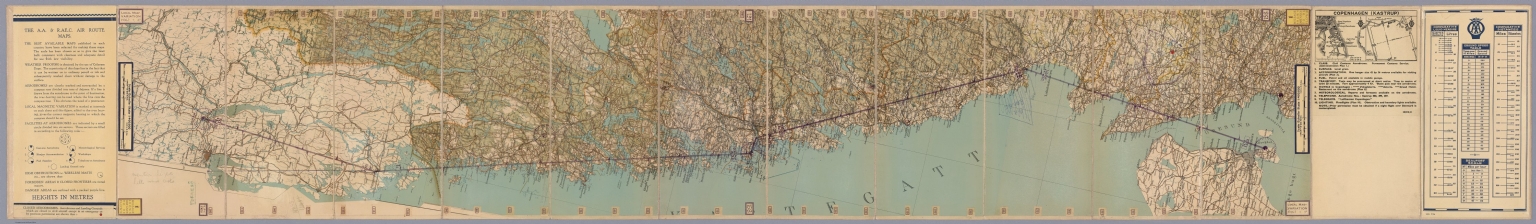
Author
[Automobile Association (U.K.), Royal Aero Club]
Full Title
(Covers to) Oslo -- Stockholm Automobile Association and The Royal Aero Club Flying Maps.
List No
15050.001
Author
[Automobile Association (U.K.), Royal Aero Club]
Full Title
Malmo and Goteborg Automobile Association and The Royal Aero Club Flying Maps.
List No
15050.002
Author
[Automobile Association (U.K.), Royal Aero Club]
Full Title
Oslo - Stockholm Automobile Association and The Royal Aero Club Flying Maps.
List No
15050.003
Author
[Automobile Association (U.K.), Royal Aero Club]
Full Title
(Composite map to) Oslo - Copenhagen - Stockholm Automobile Association and The Royal Aero Club Flying Maps.
List No
15050.004
Author
[Annand, George, Van Doren, Carl]
Full Title
Map of Sinclair Lewis's United States as it appears in his novels With Notes By Carl Van Doren. George Annand, del.
List No
13419.001
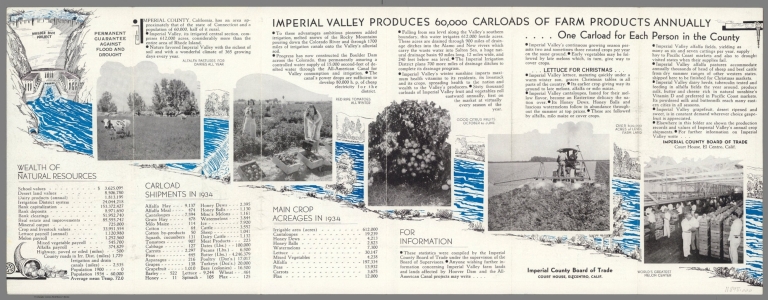
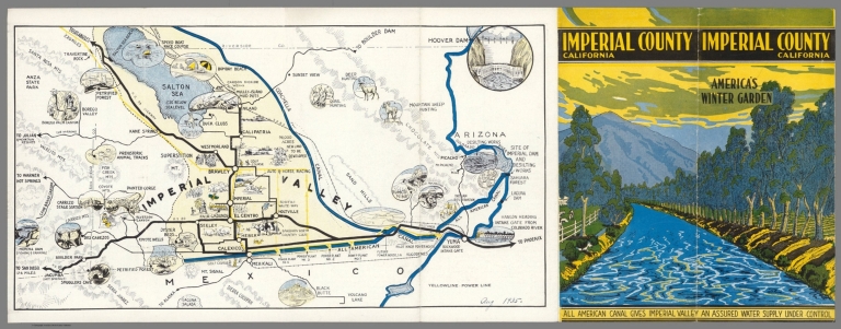
Author
Imperial County Board of Trade
Full Title
(Covers to) Imperial County California. America's Winter Garden. All American Canal gives Imperial Valley an Assured Water Supply under control. Imperial County Board of Trade. El Centro, Calif.
List No
11898.001
Note
Color pictorial map 23x40, folded to pictorial covers 23x10. Shows areas of crop and livestock production, roads, rivers, forests, wildlife, places of interest and recreation activities. Date written on lower right corner of map. Relief shown pictorially and by hachures. On verso text and photos highlights the wealth of natural resources of the Valley with information on carload shipments and main crop acreages in 1934.
Author
Imperial County Board of Trade
Full Title
(Text Page to) Imperial County California. America's Winter Garden. All American Canal gives Imperial Valley an Assured Water Supply under control. Imperial County Board of Trade. El Centro, Calif.
List No
11898.002
Note
Color pictorial map 23x40, folded to pictorial covers 23x10. Shows areas of crop and livestock production, roads, rivers, forests, wildlife, places of interest and recreation activities. Date written on lower right corner of map. Relief shown pictorially and by hachures. On verso text and photos highlights the wealth of natural resources of the Valley with information on carload shipments and main crop acreages in 1934.
Author
Imperial County Board of Trade
Full Title
Imperial County California. America's Winter Garden. All American Canal gives Imperial Valley an Assured Water Supply under control. Imperial County Board of Trade. El Centro, Calif.
List No
11898.003
Note
Color pictorial map 23x40, folded to pictorial covers 23x10. Shows areas of crop and livestock production, roads, rivers, forests, wildlife, places of interest and recreation activities. Date written on lower right corner of map. Relief shown pictorially and by hachures. On verso text and photos highlights the wealth of natural resources of the Valley with information on carload shipments and main crop acreages in 1934.
Author
Emery, Don J.
Full Title
A map of Florida for garden lovers. Published by the Garden Club of the Halifax Country Daytona Beach, Ormand & Ormand Beach. Copyright 1934. Designed by Don J. Emery- Daytona Beach.
List No
13212.002
Note
Pictorial map, bordered with decorative Art Deco illustrations of plants and bird species indigenous to Florida. Shows rich variety of flora, gardens, bird refuges, state parks, national forests, etc. Includes note describing the map, state and Garden Club seals. On verso: Text describing places of interest to lovers of both wild and cultivated gardens.
Author
[Farmer, Edward M., Board of Trustees of the Leland Stanford Junior University]
Full Title
Stanford University. Copyright 1934 by the Board of Trustees of the Leland Stanford Junior University. Edward M. Farmer.
List No
13130.000
Note
Pictorial map, not drawn to scale. Shows various buildings, orchards, roads and sport facilities. An early view of the campus without Hoover Tower and other building additions that came later.
Author
[Mezoly, Tomas, Rabong, Joao]
Full Title
3. Ruas Principais Da Parte Sul Da Cidade Do Rio De Janeiro. Tomas Mezoly & Joao Rabong.
List No
11629.004
Note
Color pictorial map the coastal areas of city of Rio De Janeiro, Brazil on 5 sheets, with an index map. Shows the area along the coast, the streets, buildings, landmarks, airport, parks and points of interest. The individual maps capture the charm of the time along with these specific regions. Date estimated.
Author
KLM Royal Dutch Airlines
Full Title
KLM Royal Dutch Airlines Amsterdam-Batavia Weekly Service. Mouton & Co., The Hague, Sept. 1934. Printed in the Netherlands.
List No
11683.000
Note
Color lithograph map. Advertisement for KLM Royal Dutch Airlines. Depicting a map of the world on global shape shows KLM and other airlines service routes. railways, steamship routes, major areas covered by KLM and other Airlines. Shows routes from Amsterdam to Batavia, via Amsterdam, London, Athens, Cairo, Baghdad, Karachi, Calcutta, Rangoon, Bangkok, Medan, Singapore and Batavia. The first issue of this map had "Weekly Service" at the bottom, but in this issue that text is covered in black and above it is "Twice Weekly Service."
Author
Dale, O.J.
Full Title
Pictorial map of the city and surroundings of Melbourne in the state of Victoria, Commonwea1th of Australia: depicting the principal highways, railways, parks, historic landscapes and associations together with divers amusements and customs prevailing in the "Queen City of the South", 1834-1934.
List No
10092.000
Note
Pictorial street map of Melbourne. Includes col. ills. and text on historical figures and events in side margins.
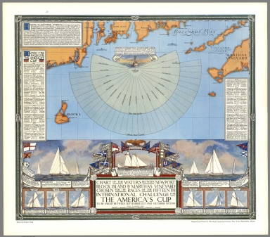
Author
Clegg, Ernest
Full Title
Chart of the Waters between Newport Block Island & Marthas Vineyard Chosen for the Races of the Fifteenth International Challenge for the America's Cup to be Sailed between September 15th and October 31st 1934. Drawn by Ernest Clegg. Engraved and Printed by the Beck Engraving Company - New York, Philadelphia, Atlanta.
List No
9828.000
Note
Pictorial map of the 1934 America's Cup yacht races, with nautical rope-form decorative border. Showing the waters of the Atlantic Ocean off the coasts of Rhode Island and Massachusetts where the race took place. At the upper portion of the map a decorative fan-like rendering of the compass directions from the starting buoy, within a ten-mile circle and a fifteen-mile circle. Cartouche are pictures of previous America's Cup yachts and their flags with explanatory notes, showing Endeavour, the 1934 challenger, and Rainbow, contending for defending honors that year and Schooner America in the middle. Includes "History of the Races for the America's Cup" listing past participants and results, and a “History of the Schooner ‘America." Apparently Clegg issued a limited edition of this print, slightly larger sized and signed by him.
Author
John Power Studios
Full Title
The Wonder Map of Melbourne drawn by John Power Studios.
List No
8575.000
Author
John Power Studios
Full Title
(Covers to) The Wonder Map of Melbourne drawn by John Power Studios.
List No
8575.001
Author
Buck, John E.
Full Title
Historical map of Vermont. by John E. Buck, C.E., Saint Albans. Copyright 1933-34. J.E.B.
List No
10063.000
Note
Historical map of Vermont, with a blue and black colored, captures the essence of the state. Map depicts the topography, administrative boundaries, and major cities. Numerous small drawings depict historical events and places, landmarks, people, activities, animals, agricultural and industrial pursuits. Includes text on lower right, and compass rose decorated with state seal.
Author
Smith, Karl
Full Title
An historical- and- geographical- map- of- the- State-of- North Carolina : Old north state". Karl Smith, March 1934. Cartographed 1934 by Karl Smith, Louisville, Kentucky.
List No
10083.000
Note
Pictorial map of North Carolina illustrates important sites, landmarks, agricultural and natural resources and historical events. Historic ships are shown in Atlantic Ocean. The map is decorated with a vignette in the lower left showing a log cabin nestled in the mountains with trees and wildflowers, a cartouche surmounted by the state seal. Includes a compass rose oriented with north to the upper right.
Author
[Imhof, Eduard, Institut Orell Fussli AG]
Full Title
(Covers to) Schulkarte Der Schweiz
List No
10510.001
Author
[Imhof, Eduard, Institut Orell Fussli AG]
Full Title
Schulkarte Der Schweiz
List No
10510.002
Author
Maine State Highway Commission
Full Title
(Covers to) Route and Pictorial Map of Maine
List No
10704.001
Author
Maine State Highway Commission
Full Title
State Highway Commission Map of Maine
List No
10704.002
Author
Maine State Highway Commission
Full Title
Maine Its Recreation and History
List No
10704.003
Author
Kellogg Company
Full Title
(Text Page to) Map of the gifts of nature to America. Kellogg Company. H.E. 34. Copr. 1932 by Kellogg Co. Printed in U.S.A.
List No
11005.001
Note
Color pictorial map of the United States. 29x43, folds to 9.5x22 in mailer envelope " from Home Economic Department Kellogg's in Battle Creek, Mich. to Mr. Ed. Collins, Boscobel, Wis. 3." Map includes text box on the bottom left and right "The story of Indian Corn" and "Facts about Kellogg's. Shows state boundaries, major cities, agriculture products, industry, livestock, forests, and compass rose oriented with the north to upper left margin. Small inset photos show original home of Corn Flakes - 1906 on top, and Home of Kellog's , Battle Creek, Mich." on the bottom. On verso: a printed form of letter headed " "A message to teachers" from Kellogg's Home Economic Department, signed by Barbara B. Brooks. and illustrated page titled "the story of corn and Corn flakes".
Author
Kellogg Company
Full Title
Map of the gifts of nature to America. Kellogg Company. H.E. 34. Copr. 1932 by Kellogg Co. Printed in U.S.A.
List No
11005.002
Note
Color pictorial map of the United States. 29x43, folds to 9.5x22 in mailer envelope " from Home Economic Department Kellogg's in Battle Creek, Mich. to Mr. Ed. Collins, Boscobel, Wis. 3." Map includes text box on the bottom left and right "The story of Indian Corn" and "Facts about Kellogg's. Shows state boundaries, major cities, agriculture products, industry, livestock, forests, and compass rose oriented with the north to upper left margin. Small inset photos show original home of Corn Flakes - 1906 on top, and Home of Kellog's , Battle Creek, Mich." on the bottom. On verso: a printed form of letter headed " "A message to teachers" from Kellogg's Home Economic Department, signed by Barbara B. Brooks. and illustrated page titled "the story of corn and Corn flakes".
Author
Harrison, Richard Edes
Full Title
The Radium Trail 1934 : Edmonton to Echo Bay. Richard Edes Harrison.
List No
11061.000
Note
Uncolored map. Relief shown by hachures and spot heights. Published in Fortune (Magazine). Shows rivers, lakes, distances, trading posts, route of 97 gold rush, trails, railways, mines, radio stations, steamship and air routes.
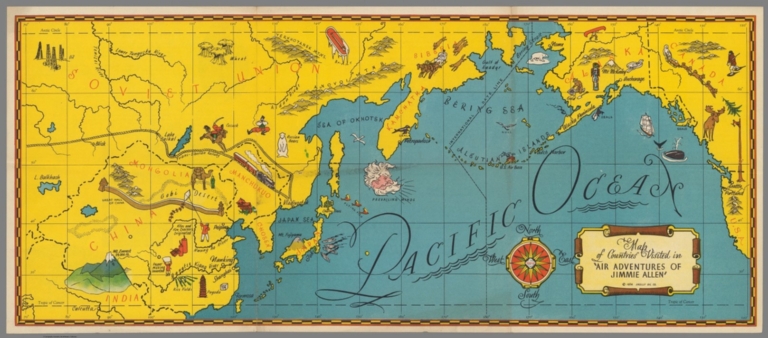
Author
Skelly Oil Company.
Full Title
Map of countries visited by "Air adventures of Jimmy Allen". (Copyright) 1934 Skelly Oil Co. (Text on verso).
List No
11105.001
Note
Color pictorial map. Showing Pacific Ocean, United States and Canada to the north to India to the south. Shows political boundaries, roads, railroads, some landmarks, place names, agriculture and industry, oil fields, etc. Relief shown pictorially. Text on verso: signed by Jimmy Allen and Ernie Smith, including uncolored photos.
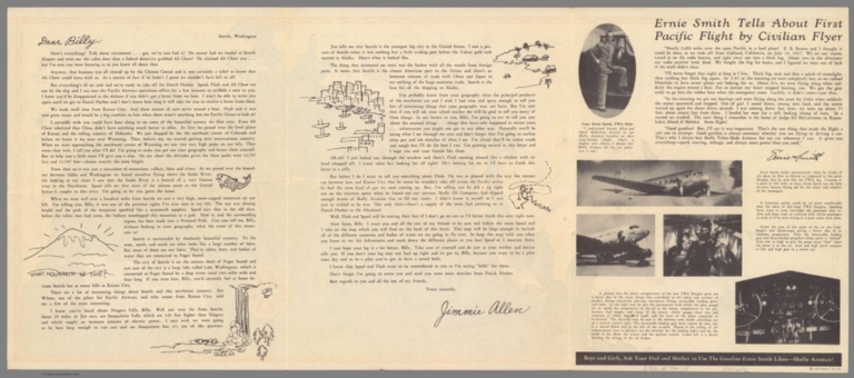
Author
Skelly Oil Company.
Full Title
(Text Page to) Map of countries visited by "Air adventures of Jimmy Allen". (Copyright) 1934 Skelly Oil Co. (Text on verso).
List No
11105.002
Note
Color pictorial map. Showing Pacific Ocean, United States and Canada to the north to India to the south. Shows political boundaries, roads, railroads, some landmarks, place names, agriculture and industry, oil fields, etc. Relief shown pictorially. Text on verso: signed by Jimmy Allen and Ernie Smith, including uncolored photos.
Author
Harper, E.L.
Full Title
A map of Greenwich Village showing some of its historical, artistic, literary, educational, and religious places of interest. Published by the Villager, copyright 1934. E L Harper.
List No
11206.000
Note
Pictorial map of Greenwich Village in New York City with illustrations of landmarks and sites, historic district boundaries and streets. Includes decorative title cartouche and compass rose oriented with the north to the left margin.
Author
Smith, Karl
Full Title
An Historical Map of the City of Louisville : situated at the falls of the Ohio in the county of Jefferson in the Commonwealth of Kentucky. 1934 designed by Karl Smith Louisville KY. Copyrighted 1934 by Karl Smith, Louisville, KY.
List No
11210.000
Note
Pictorial map of the City of Louisville showing the city plan in the background and highlights the important sites, landmarks, parks and rivers. Borders with vignettes of Louisville scenes, structures and historical events. Includes explanations, Louisville seals, compass rose, and portraits of General George Rogers Clark and Louis XVI at the lower edge of the map.
Author
[Hoxie, Jerome S., League of Women Voters (Tolland County, Conn.)]
Full Title
Map of Tolland County, Conn. Published for the Tolland County League of Women Voters. Drawings by S Jerome Hoxie. Printed by the Riverside Press, Mystic. Copyrighted 1934.
List No
11279.000
Note
Pictorial map, divided into towns with explanatory text, showing illustrations of historic sites, important buildings, Indian reservations, agriculture, etc. Includes a decorative title cartouche and compass rose oriented with north to upper right.
Author
[Ray, Don, Townsend, B.]
Full Title
The Connecticut - College for Women. A decorative map. Don Ray Del. Don Ray 1934 ; B. Townsend.
List No
11390.000
Note
Pictorial map, with title cartouche decorated with the college logo. Shows campus buildings and facilities for women. Map borders at the upper and lower panels with small illustrations of buildings, scenes, graduation ceremony and campus activities. Includes notes and compass rose oriented with the north to upper left.
Author
[Sarg, Anthony Frederick, Central Savings Bank]
Full Title
(Covers to) A Map of Greenwich Village by Tony Sarg. Central Savings Bank. Fourth Ave. at 14th Street. Broadway at 73rd. Street. (Cover title) Tony Sarg's Map of Greenwich Village. Central Savings Bank, New York. 1859-1934, 75 years old.
List No
11399.001
Note
Color pictorial map, 35x27, on sheet 45.5x30.5, folded in mailing envelope 23x15.5, with decorative title cartouche. Produced as a promotion for Central Savings Bank on the occasion of its 75th anniversary, with promotional text on the back invited potential customers. Designed by designer, decorator, cartoonist, illustrator, sculptor, writer and lecturer. Anthony Frederick Sarg, born in Guatemala to a German father and English mother, moved to New York City in 1915. He became a U.S. citizen in 1920. He was an illustration artist for various publications including the Saturday Evening Post. In 1917. Map shows Greenwich Village in New York City with people in various activities, streets, landmarks and buildings, such as the Salmagundi Club, the Washington Square Arch and New York University. Includes a key below the cartouche provides a guide to restaurants, stores, bars, and the Whitney Museum of American Art at its former West 8th Street location. In the lower margin, shows portraits of Mark Twain and Washington Irving.
Author
[Sarg, Anthony Frederick, Central Savings Bank]
Full Title
A Map of Greenwich Village by Tony Sarg. Central Savings Bank. Fourth Ave. at 14th Street. Broadway at 73rd. Street. (Cover title) Tony Sarg's Map of Greenwich Village. Central Savings Bank, New York. 1859-1934, 75 years old.
List No
11399.002
Note
Color pictorial map, 35x27, on sheet 45.5x30.5, folded in mailing envelope 23x15.5, with decorative title cartouche. Produced as a promotion for Central Savings Bank on the occasion of its 75th anniversary, with promotional text on the back invited potential customers. Designed by designer, decorator, cartoonist, illustrator, sculptor, writer and lecturer. Anthony Frederick Sarg, born in Guatemala to a German father and English mother, moved to New York City in 1915. He became a U.S. citizen in 1920. He was an illustration artist for various publications including the Saturday Evening Post. In 1917. Map shows Greenwich Village in New York City with people in various activities, streets, landmarks and buildings, such as the Salmagundi Club, the Washington Square Arch and New York University. Includes a key below the cartouche provides a guide to restaurants, stores, bars, and the Whitney Museum of American Art at its former West 8th Street location. In the lower margin, shows portraits of Mark Twain and Washington Irving.
Author
Sims, Joseph P.
Full Title
Horse map of the World. Designed by Joseph P. Sims. Copyright 1934. This limited edition published by Miller's 123 East 24th. St. New York, New York.
List No
11404.000
Note
Pictorial map of the world. Drawn by Joseph P Sims. Borders with illustrations of 28 Different Breeds with text describing country of origin and weight. Explanation at the bottom center describes horse breeds on the pictures: "On the border of the map are shown the better known breads of horses ..." Library has reprint edition, 1936: see: 8788.000. Includes explanatory notes on the map.
Author
[Gesner, F. Norton, 1875-1955, Wethersfield Business Men's & Civic Association]
Full Title
Cultural and historical map of old Wethersfield, Connecticut, commemorating the celebration attending the tercentenary, 1634-1934. Compiled by the Wethersfield Business Men's & Civic Association. Wethersfield, Conn. Drawn by F. Norton Gesner. Litho. by Kellogg & Bulkeley Co. Litho. by Kellogg & Bulkeley Co. Hartfod, Conn. C. The W.B. M. & C.A. 1934. (insets) The Web house. (with) Old Academy. (with) Old Shipyard.
List No
11469.000
Note
Colored pictorial map. Surrounded by vignettes of historic buildings, people and events at the sides and top, and historical notes at the bottom. Shows roads, rivers, landmarks, and historic events and people. Includes 3 inset views and text. Relief shown by hachures.
Author
[Mezoly, Tomas, Rabong, Joao]
Full Title
1. Ruas Principais Da Parte Sul Da Cidade Do Rio De Janeiro. Tomas Mezoly & Joao Rabong.
List No
11629.002
Note
Color pictorial map the coastal areas of city of Rio De Janeiro, Brazil on 5 sheets, with an index map. Shows the area along the coast, the streets, buildings, landmarks, airport, parks and points of interest. The individual maps capture the charm of the time along with these specific regions. Date estimated.
Author
[Mezoly, Tomas, Rabong, Joao]
Full Title
2. Ruas Principais Da Parte Sul Da Cidade Do Rio De Janeiro. Tomas Mezoly & Joao Rabong.
List No
11629.003
Note
Color pictorial map the coastal areas of city of Rio De Janeiro, Brazil on 5 sheets, with an index map. Shows the area along the coast, the streets, buildings, landmarks, airport, parks and points of interest. The individual maps capture the charm of the time along with these specific regions. Date estimated.
Author
[Mezoly, Tomas, Rabong, Joao]
Full Title
4. Ruas Principais Da Parte Sul Da Cidade Do Rio De Janeiro. Tomas Mezoly & Joao Rabong.
List No
11629.005
Note
Color pictorial map the coastal areas of city of Rio De Janeiro, Brazil on 5 sheets, with an index map. Shows the area along the coast, the streets, buildings, landmarks, airport, parks and points of interest. The individual maps capture the charm of the time along with these specific regions. Date estimated.
Author
[Mezoly, Tomas, Rabong, Joao]
Full Title
5. Ruas Principais Da Parte Sul Da Cidade Do Rio De Janeiro. Tomas Mezoly & Joao Rabong.
List No
11629.006
Note
Color pictorial map the coastal areas of city of Rio De Janeiro, Brazil on 5 sheets, with an index map. Shows the area along the coast, the streets, buildings, landmarks, airport, parks and points of interest. The individual maps capture the charm of the time along with these specific regions. Date estimated.
Author
Hayden Map Co.
Full Title
Mammoth Lakes : Mono County, Cal. Circle of enchantment. the paradise of theSierra. Map compiled and published by Hayden Map 'co., Glendale Cal. 1934. (insets) Detail map Mammoth Lakes. (with) Detail map Devil Post Pile. (with) Highway detail.
List No
11680.000
Note
Highly detailed advertising and trail circular map of the area around Mammoth Lake in Mono County, California. Shows county and forest boundaries, highways, roads, trails, distances, rivers, bridges, swamps, marshes, lakes,buildings, lodges, ranches, etc. The map provides advertising for many of the area businesses, including Lake Mary Pack Train store. The Hayden Map Company was founded in the 1930s by Emmet Hayden. In 1927, Emmet Hayden procured a lease in the Inyo National Forest, where he built a four bedroom log cabin which is the Mammoth Lakes Museum today. Hayden was an Engineer, Surveyor, and Mapmaker by training.
Author
Oppenheim, Victor
Full Title
Mapa Geologico do Brasil Meridional, Sedimentos e Derrames de Balsaltos Gondwanicos (southern sheet).
List No
12012.001
Author
Oppenheim, Victor
Full Title
Mapa Geologico do Brasil Meridional, Sedimentos e Derrames de Balsaltos Gondwanicos (northern sheet).
List No
12012.002
Author
Oppenheim, Victor
Full Title
(Composite Map) Mapa Geologico do Brasil Meridional, Sedimentos e Derrames de Balsaltos Gondwanicos.
List No
12012.003
Author
[Double, Lee R., Lindgren, Jolly (1895-1952)]
Full Title
Hysterical Map of Olympic Peninsula and Puget Sound Country, a Trifle Cockeyed.
List No
12155.000
|


![[Pictorial Map Cutsheet Advertisement for] Map of the SUrface-Feeding Ducks, Swans and Geese of North America](https://media.davidrumsey.com/MediaManager/srvr?mediafile=/Size3/RUMSEY~8~1/199/15385002.jpg)
![圖地觀大業產界世 世界に雄飛する日本商品 [Japanese Products that Travel the World / The World of Big Business].](https://www.davidrumsey.com/rumsey/Size2/RUMSEY~8~1/199/15154000.jpg)