|
REFINE
Browse All : Separate Map from 1924
1-38 of 38
Author
Engineer Office 9th Corps
Full Title
Map of The Presidio of San Francisco California. Traced in the Engineer Office Headquarters 9th Corps Area. March 1924.
List No
15815.000
Author
Gutierrez, Pedro (fl. 1900 - 1957)
Full Title
Plano de Subdivision Country Club Park. Propiedad Del County Club Park Investment Company. Habana Cuba 1924
List No
15581.000
Author
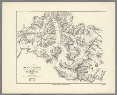
[Royal Geographical Society, Wheeler, Major]
Full Title
Sketch Map of Mount Everest from Surveys by Major Wheeler in 1921 With additions by the Expedition of 1924.
List No
15025.000
Note
Date estimated
Author
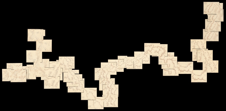
[Birdseye, C.H., Burchard, R.W., U.S. Geological Survey]
Full Title
(Composite map of) Sheets A - N. Plan and Profile of Colorado River From Lees Ferry, Ariz., To Black Canyon, Ariz.-Nev., and Virgin River, Nev. 21 Sheets (14 plans, 7 profiles).
List No
10974.001
Author
[Birdseye, C.H., Burchard, R.W., U.S. Geological Survey]
Full Title
Sheet A. Plan and Profile of Colorado River From Lees Ferry, Ariz., To Black Canyon, Ariz.-Nev., and Virgin River, Nev. 21 Sheets (14 plans, 7 profiles).
List No
10974.002
Author
[Birdseye, C.H., Burchard, R.W., U.S. Geological Survey]
Full Title
Sheet B. Plan and Profile of Colorado River From Lees Ferry, Ariz., To Black Canyon, Ariz.-Nev., and Virgin River, Nev. 21 Sheets (14 plans, 7 profiles).
List No
10974.003
Author
[Birdseye, C.H., Burchard, R.W., U.S. Geological Survey]
Full Title
Sheet C. Plan and Profile of Colorado River From Lees Ferry, Ariz., To Black Canyon, Ariz.-Nev., and Virgin River, Nev. 21 Sheets (14 plans, 7 profiles).
List No
10974.004
Author
[Birdseye, C.H., Burchard, R.W., U.S. Geological Survey]
Full Title
Sheet D. Plan and Profile of Colorado River From Lees Ferry, Ariz., To Black Canyon, Ariz.-Nev., and Virgin River, Nev. 21 Sheets (14 plans, 7 profiles).
List No
10974.005
Author
[Birdseye, C.H., Burchard, R.W., U.S. Geological Survey]
Full Title
Sheet E. Plan and Profile of Colorado River From Lees Ferry, Ariz., To Black Canyon, Ariz.-Nev., and Virgin River, Nev. 21 Sheets (14 plans, 7 profiles).
List No
10974.006
Author
[Birdseye, C.H., Burchard, R.W., U.S. Geological Survey]
Full Title
Sheet F. Plan and Profile of Colorado River From Lees Ferry, Ariz., To Black Canyon, Ariz.-Nev., and Virgin River, Nev. 21 Sheets (14 plans, 7 profiles).
List No
10974.007
Author
[Birdseye, C.H., Burchard, R.W., U.S. Geological Survey]
Full Title
Sheet G. Plan and Profile of Colorado River From Lees Ferry, Ariz., To Black Canyon, Ariz.-Nev., and Virgin River, Nev. 21 Sheets (14 plans, 7 profiles).
List No
10974.008
Author
[Birdseye, C.H., Burchard, R.W., U.S. Geological Survey]
Full Title
Sheet H. Plan and Profile of Colorado River From Lees Ferry, Ariz., To Black Canyon, Ariz.-Nev., and Virgin River, Nev. 21 Sheets (14 plans, 7 profiles).
List No
10974.009
Author
[Birdseye, C.H., Burchard, R.W., U.S. Geological Survey]
Full Title
Sheet I. Plan and Profile of Colorado River From Lees Ferry, Ariz., To Black Canyon, Ariz.-Nev., and Virgin River, Nev. 21 Sheets (14 plans, 7 profiles).
List No
10974.010
Author
[Birdseye, C.H., Burchard, R.W., U.S. Geological Survey]
Full Title
Sheet J. Plan and Profile of Colorado River From Lees Ferry, Ariz., To Black Canyon, Ariz.-Nev., and Virgin River, Nev. 21 Sheets (14 plans, 7 profiles).
List No
10974.011
Author
[Birdseye, C.H., Burchard, R.W., U.S. Geological Survey]
Full Title
Sheet K. Plan and Profile of Colorado River From Lees Ferry, Ariz., To Black Canyon, Ariz.-Nev., and Virgin River, Nev. 21 Sheets (14 plans, 7 profiles).
List No
10974.012
Author
[Birdseye, C.H., Burchard, R.W., U.S. Geological Survey]
Full Title
Sheet L Plan and Profile of Colorado River From Lees Ferry, Ariz., To Black Canyon, Ariz.-Nev., and Virgin River, Nev. 21 Sheets (14 plans, 7 profiles).
List No
10974.013
Author
[Birdseye, C.H., Burchard, R.W., U.S. Geological Survey]
Full Title
Sheet M. Plan and Profile of Colorado River From Lees Ferry, Ariz., To Black Canyon, Ariz.-Nev., and Virgin River, Nev. 21 Sheets (14 plans, 7 profiles).
List No
10974.014
Author
[Birdseye, C.H., Burchard, R.W., U.S. Geological Survey]
Full Title
Sheet N. Plan and Profile of Colorado River From Lees Ferry, Ariz., To Black Canyon, Ariz.-Nev., and Virgin River, Nev. 21 Sheets (14 plans, 7 profiles).
List No
10974.015
Author
Harumoto, Ogawa
Full Title
World New Cartoon Bird View Map. (inset) (Small world political map with names in Japanese and English).
List No
12233.000
Author
Egypt. Maṣlaḥat al-Misāḥah.
Full Title
Map of Cairo showing Mohammedan Monuments.
List No
10482.000
Note
"This exceedingly high-quality map depicts ‘Old Cairo’, the parts of the city that were founded during medieval times, located on the highlands above the ‘newer’ neighbourhoods along the Nile. It was created by the Survey of Egypt, then one of the most professional mapping agencies in the World, predicated upon the synergy of the most authoritative topographical and urban mapping combined with the latest archaeological surveys. Cairo was the greatest centre of culture, learning and commerce during the ‘Islamic Golden age’. Commencing in the early 20th Century professional archaeologists as well as art and architectural historians became interested in scientifically recording Cairo’s sensational Islamic buildings and monuments. The map employs colours to denote sites built across the city during the eras of the three great Islamic empires that controlled Cairo prior to the arrival of the Ottomans in 1517: the ‘Fatimid and Pre-Fatimid Monuments’ (909 - 1171), shaded in Red; the ‘Aiyubid [Ayyubid] Monuments’ (1171 - 1260), shaded in Green; and the ‘Mameluke Monuments’ (1260 - 1517), shaded in Blue. These mosques, palaces, madrassas, and fortifications appear amidst the otherwise buff-coloured city which generally consisted of buildings built during the subsequent Ottoman and British Protectorate periods. The map shows that many of the greatest edifices from the periods of the three great Islamic empires have survived, although only traces of the vast Fatimid Place can be found amongst the foundations of newer buildings. Each of the historical sites is named in Gothic script and features a corresponding numeral which refers to that which appears upon the plaques affixed to each building by the civic authorities. The two insets on the left-hand side showcase sites in areas outside of the city proper. We understand that the first edition the map was issued in 1924, while an Arabic language version was published in 1948. The present revised, official edition was issued in 1950-1 (correction, this copy is the first edition, issued in 1924), while several facsimile (unofficial) versions have been issued since then. The Survey of Egypt followed the initial production of the present issue of the map with a small booklet, Index to Mohammedan monuments appearing on the special 1:5000 scale maps of Cairo (Cairo, 1951), that is not present here, but seems to have been issued with the latter-releases of the map. Cairo during the ‘Islamic Golden Age’ Cairo was traditionally the largest and most culturally and economically important city in the Islamic world. The Muslim conquest of Byzantine Egypt occurred between 639 and 646 AD. While the Cairo area has been settled for thousands of years, with the key Ancient Egyptian cities of Giza and Memphis located nearby, the city proper was not founded until 969, when it became the principal city, and sometimes capital, of the Fatimid Caliphate, a Shia Muslim empire which controlled much of North Africa, the Levant and Hejaz between 909 and 1171. Cairo rapidly rose to become a centre of great wealth, at the nexus of global trade routes as well as home to some of the world’s foremost centres of education and the arts. Befitting tis importance, great monuments of Islamic architecture were built across the city. The Al-Azhar Madrassa (no. 97 on the map), which later grew into a university, was founded in 970-2 and today remains the world’s most prestigious institute of Islamic learning. The map notes some Islamic monuments made before 969, as the pre-Cairo rural landscape featured some small mosques, houses and fortifications. The Fatimids were replaced by the Ayyubid Dynasty (1171 - 1260), a regime of Kurdish origin, founded by the legendary conqueror Saladin, whereupon Cairo remained the prosperous centre of an empire spanning much of the Middle East. The Mamelukes were an elite class of soldier-bureaucrats descended from former Christian slaves. In 1250, they took over Egypt, the Levant and Hejaz, forming the Mameluke Sultanate, with its capital in Cairo. It was during the early part of their regime that Cairo reached its zenith as the principal centre of the Islamic Golden Age. The epicentre of a global trading network that spanned from India to Spain, Cairo far surpassed all European cities in wealth and cultural sophistication, and many exquisite works of architecture were built to reflect this glorious state. The Mameluke Sultanate was conquered by the Ottomans in 1517 and Cairo ceased to be an imperial capital. However, while technically subject to the Sublime Porte, Egypt maintained a high degree of autonomy and was the wealthiest and most prosperous part of the Ottoman Empire; Cairo remained a highly important centre. Fortunately, as the repent map reveals, the survival rate of Cairo’s great works of Islamic architecture from the Fatimid, Ayyubid and Mameluke periods is impressively high, and many sites can be visited today. References: OCLC: 17543226." (Alexander Johnson, 2020)
Author
[Derrick, Thomas, 1885-1954, Bawden, Edward, 1903-1989]
Full Title
London's Underground to Wembley. Thomas Derrick & Bawden. 1924. Eyre & Spottiswoode Ltd., H.M. Printers, London.
List No
13291.000
Note
"Rare pictorial map / advertising poster for promoting subway transportation to the British Empire Exhibition at Wembley. The image illustrates Wembley's Football (soccer) Stadium in the center of the image surrounded by a multitude of people, places, disciplines, and activities representing the British Empire. The artist collaborators for the image were: Edward Bawden (British, 1903–1989), a successful and prolific illustrator and graphic designer whose commissions included designs for posters, books, ceramic decorations, wallpaper, textiles, and murals and who also taught graphic design at the Royal College of Art, designed posters and ephemera for both the Underground Group and London Transport for over a quarter century. Thomas Derrick (British, 1885–1954), best known for his mural and illustration work, also painted portraits and designed stained glass. He produced posters for the Underground Group from 1924 to 1927. As noted by the entry for the map in the London Transit Museum: This poster was commissioned by the Underground in 1924. The brief was an illustrated map of the British Empire Exhibition at Wembley. Frank Pick approached Edward Bawden for the commission on the recommendation of Bawden's tutor at the Royal College of Art. Pick rejected Bawden's first proposal and brought in the more experienced designer, Thomas Derrick. Derrick handled the cartography and overall design, and Bawden was left to provide the illustrations. From a distance the poster was hard to read, but it was extremely popular with the public for its exquisite attention to detail. The map was printed in London by Eyre & Spottiswoode Ltd., H.M. Printers." (Ruderman)
Author
[Birdseye, C.H., Burchard, R.W., U.S. Geological Survey]
Full Title
Sheet O. Plan and Profile of Colorado River From Lees Ferry, Ariz., To Black Canyon, Ariz.-Nev., and Virgin River, Nev. 21 Sheets (14 plans, 7 profiles).
List No
10974.016
Author
[Birdseye, C.H., Burchard, R.W., U.S. Geological Survey]
Full Title
Sheet P. Plan and Profile of Colorado River From Lees Ferry, Ariz., To Black Canyon, Ariz.-Nev., and Virgin River, Nev. 21 Sheets (14 plans, 7 profiles).
List No
10974.017
Author
[Birdseye, C.H., Burchard, R.W., U.S. Geological Survey]
Full Title
Sheet Q. Plan and Profile of Colorado River From Lees Ferry, Ariz., To Black Canyon, Ariz.-Nev., and Virgin River, Nev. 21 Sheets (14 plans, 7 profiles).
List No
10974.018
Author
[Birdseye, C.H., Burchard, R.W., U.S. Geological Survey]
Full Title
Sheet R. Plan and Profile of Colorado River From Lees Ferry, Ariz., To Black Canyon, Ariz.-Nev., and Virgin River, Nev. 21 Sheets (14 plans, 7 profiles).
List No
10974.019
Author
[Birdseye, C.H., Burchard, R.W., U.S. Geological Survey]
Full Title
Sheet S. Plan and Profile of Colorado River From Lees Ferry, Ariz., To Black Canyon, Ariz.-Nev., and Virgin River, Nev. 21 Sheets (14 plans, 7 profiles).
List No
10974.020
Author
[Birdseye, C.H., Burchard, R.W., U.S. Geological Survey]
Full Title
Sheet T. Plan and Profile of Colorado River From Lees Ferry, Ariz., To Black Canyon, Ariz.-Nev., and Virgin River, Nev. 21 Sheets (14 plans, 7 profiles).
List No
10974.021
Author
[Birdseye, C.H., Burchard, R.W., U.S. Geological Survey]
Full Title
Sheet U. Plan and Profile of Colorado River From Lees Ferry, Ariz., To Black Canyon, Ariz.-Nev., and Virgin River, Nev. 21 Sheets (14 plans, 7 profiles).
List No
10974.022
Author
Ruep, Joseph
Full Title
(Covers to) Carta a Relievo Plastico Automobilistica delle Dolomiti (Italia). Publicata Dall' Hotel Karersee Carezza al Lago, Dolomiti (Italia).
List No
12105.001
Note
Printed on back of map.
Author
Ruep, Joseph
Full Title
Carta a Relievo Plastico Automobilistica delle Dolomiti (Italia). Publicata Dall' Hotel Karersee Carezza al Lago, Dolomiti (Italia).
List No
12105.002
Author
[Daidy, George A., Bauman Jr., Wm., Berthrong, I.P., U.S. General Land Office]
Full Title
State of Washington. General Land Office.
List No
12408.000
Author
Kremers, Laura
Full Title
A historical map of Madison. Designed by Laura Kremers of the Colt Studio of Commercial Art, Madison, Wisconsin.
List No
13282.000
Author
Clegg, Ernest
Full Title
Mappa aestivarum Insularum alias Barmudas dictarum ... Ernest Clegg - New York - 1924. From the painting by Ernest Clegg. Country Life Print.
List No
13480.000
Author
USGS (U.S. Geological Survey)
Full Title
Dardanelles, Calif.
List No
6213.000
Note
Edition of 1898, reprinted 1924. 30-minute topographic quadrangle with relief shown as contours. Includes areas of Yosemite National Park, Sonora Pass, Stanislaus River.
Author
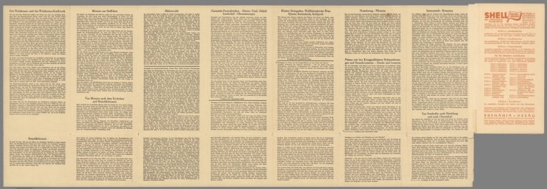
[Peiner, Werner, Gobich, Hanns]
Full Title
(Covers to) Oberbayern Westlicher Teil. Shell-Oberbayern-Karte. (Upper Bavaria Western part. Shell Upper Bavaria map.)
List No
9000.001
Note
Date estimated.
Author
[Peiner, Werner, Gobich, Hanns]
Full Title
(Text to) Oberbayern Westlicher Teil. Shell-Oberbayern-Karte. (Upper Bavaria Western part. Shell Upper Bavaria map.)
List No
9000.002
Note
Date estimated.
Author
[Peiner, Werner, Gobich, Hanns]
Full Title
Oberbayern Westlicher Teil. Shell-Oberbayern-Karte. (Upper Bavaria Western part. Shell Upper Bavaria map.)
List No
9000.003
Note
Date estimated.
Author
United States. Post Office Department
Full Title
Post Route Map of the State of Michigan Showing Post Offices with the Intermediate Distances on Mail Route ... August, 1924. (inset) Detroit & Vicinity.
List No
9129.000
1-38 of 38
|