|
REFINE
Browse All : Separate Map from 1869
1-28 of 28
Author
Palmer, William. J.
Full Title
Map Of The Route Of The Southern Continental R.R. With Connections From Kansas City Mo. Ft. Smith Ark. And Shreveport La. Giving a general View of the Recent Surveys of the Kansas Pacific Railway Co, across the Continent Made in 1867 & 1868 under the direction of Gen. Wm. J. Palmer. On the routes of the 32nd and 35th Parallels. J.F Gedney Lith, Washington, D.C.
List No
3725.000
Note
Removed from Palmer's 1869 "Report of Surveys...for a route extending the Kansas Pacific Railway to the Pacific Ocean." Palmer used an exact copy Keeler's 1868 reduced scale edition of his National Map of the United States without credit in this first issue although Palmer's map adds much material along the line of the proposed southern continental route, especially in the Grand Canyon; in fact, this map is best known as the first map to use the name "Grand Canyon" of the Colorado. The Kansas Pacific had dreams of extending their line to California, as shown on this map, but it never happened. The map shows the routes of the Northern Pacific, the Union and Central Pacific, and the Southern Route. Ms color red and blue lines have been drawn on the various routes, adding an additional route from Centreville, Nevada, to Portland, Oregon (probably following Dodge's proposals - see his report). The main Kansas Pacific line has at least sixteen proposed branches! There is a later issue of this map that credits Keeler as a source (see our copy).
Author
Palmer, William. J.
Full Title
Map Of The Route Of The Southern Continental R.R. With Connections From Kansas City Mo. Ft. Smith Ark. And Shreveport La. Giving a general View of the Recent Surveys of the Kansas Pacific Railway Co, across the Continent Made in 1867 & 1968 under the direction of Gen. Wm. J. Palmer. On the routes of the 32nd and 35th Parallels together with compilations from Keeler's Official Map showing the Central and Northern Routes to the Pacific, and the intermediate topography. J.F Gedney Lith, Washington, D.C.
List No
4692.000
Note
This is a somewhat later issue of the Palmer map that adds a Keeler credit in the title, above the title adds the date June 1869 next to three railroad symbol explanations, and adds a table of "Distances by the Kansas Pacific Railway to Denver & Cheyenne thence by the Pacific Railroad to San Francisco," and eliminates the "explanations" in the lower right.
Author
[Schièble, Erhard, 1821-1880, Lanée, E.]
Full Title
(Covers to) سويش بوغازى واطرافلريند خريطه سى [Süveyş boğazı ve etraflarinde harita-sı / Map of the Suez Canal and its Surroundings]
List No
10599.001
Author
[Schièble, Erhard, 1821-1880, Lanée, E.]
Full Title
سويش بوغازى واطرافلريند خريطه سى [Süveyş boğazı ve etraflarinde harita-sı / Map of the Suez Canal and its Surroundings]
List No
10599.002
Author
Coghlan, John
Full Title
Buenos Ayres mejoras de la ciudad : proyecto de demostrativo de los niveles y configuración natural de la Ciudad. 1869. John Coghlan.
List No
13274.000
Note
Color map showing improvement of the city, street, city blocks, roads, rivers and bridges. Relief shown by hachures. Depth shown by isolines. Includes notes. Escala de Varas. A very early map of Buenos Aires.
Author
[Voisin, Francois Philippe, 1821-1918, Schièble, Erhard (1821 - 1880)]
Full Title
Compagnie universelle du Canal maritime de Suez : Carte de l'isthme. dresse sous la direction de Mr. Voisin, Dircteur G.al des Travaux, et d'apres les operations de Mr. Larousse, Ingenier-Hydrographe. E. Andriveau Goujon, editeur, 1869. Grave par Erhard. Paris - Imp. Lemercier.
List No
13106.002
Note
Chromolithograph map, on sheet 119x81, sectioned to 32 panels folded to 24x14, backed with linen. Housed in marbled slipcase with title "Suez Canal" on spine. Map covers eastern part of the Nile Delta. Shows roads and railways. Relief shown by shadings. Insets including profile of the Canal and geological cross section diagram. Seller's label of "Simon Schropp & Co., Berlin" on verso.
Author
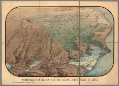
Vimercati, Cesare
Full Title
Panorama del Basso-Egitto - Canale Artificiale di Suez. Proprieta C. Vimercati posta sotto la tutela delle vigenti Leggi in fatto di stampa. Rapporto di 1:260 000 sulla scala di 2 chilometri a centimetro.
List No
11001.000
Note
Color panoramic view of the Nile River Delta and the Suez Canal region, on sheet 70x97, dissected into 6 sections, mounted on linen, 35x32.5. Shows settlements, roads and trails. Date estimated. Relief shown pictorially.
Author
United States Coast Survey
Full Title
San Francisco Peninsula. U.S. Coast Survey. Benjamin Peirce, Superintendent. 1869. Price $1.50. Verified J.E. Hilgard. Assist Coast Survey. In Charge of Office.
List No
2648.000
Note
Heavy paper chart; uses contour lines. This is one of the first Coast Survey charts that we have seen that uses contour lines, other than the 1859 City of San Francisco and Its Vicinity (see our copy). Map without color. Published as map #14 in the "Report of the Superintendent of the United States Coast Survey, Showing the Progress of the Survey During the Year 1869." The report was finally published in 1872 and was the House of Representatives report from the 41st Congress, 2d Session, Ex. Doc. No. 206.
Author
[Voisin, Francois Philippe, 1821-1918, Schièble, Erhard (1821 - 1880)]
Full Title
(Covers to) Compagnie universelle du Canal maritime de Suez : Carte de l'isthme. dresse sous la direction de Mr. Voisin, Dircteur G.al des Travaux, et d'apres les operations de Mr. Larousse, Ingenier-Hydrographe. E. Andriveau Goujon, editeur, 1869. Grave par Erhard. Paris - Imp. Lemercier.
List No
13106.001
Note
Chromolithograph map, on sheet 119x81, sectioned to 32 panels folded to 24x14, backed with linen. Housed in marbled slipcase with title "Suez Canal" on spine. Map covers eastern part of the Nile Delta. Shows roads and railways. Relief shown by shadings. Insets including profile of the Canal and geological cross section diagram. Seller's label of "Simon Schropp & Co., Berlin" on verso.
Author
Wheeler, G.M.
Full Title
Map showing Detailed Topography Of The Country Traversed by the Reconnaissance Expedition through Southern & Southeastern Nevada in charge of Lieut. Geo. M. Wheeler U.S. Engineers. Assisted by Lieut. O.W. Lockwood Corps Of Engineers U.S.A. 1869. P.W. Hamel Chief Topographer And Draughtsman. Photolith. by the N.Y. Lithg. Engrg. & Prtg. Co. 16 & 18 Park Place.
List No
2739.000
Note
1st Wheeler map, done before 100th Mer. Survey. Streeter: "Since Wheeler's exploration was in part over country never before mapped, this as far as I know, is the foundation map for southern Nevada." Above the neat line reads "Reconnaissance Maps. Department Of California." Unfolded separate issue. Outline color by county.
Author
Freyhold, Edward
Full Title
Office Of The Chief Of Engineers War Department Military Map of the United States compiled and drawn by E. Freyhold 1869. Engraved & printed by Julius Bien, N.Y. (inset map) Territory Of Alaska.
List No
3849.001
Note
Upper left sheet. A four sheet map of the entire United States, derived from the Warren/Freyhold Map of the Western Territories of 1868. A note under the title states "In the compilation of this map the Authorities designated on the map of the Western Territories as well as others of more recent date have been used." The topography is simplified from the earlier map, the scale reduced, and the transpacific railroad is shown completed. The Military Districts are outlined in red; map is in full color. There was another issue in 1870 (Hudson #8-82, Civil War Maps). Relief shown by shadings.
Author
Freyhold, Edward
Full Title
Office Of The Chief Of Engineers War Department Military Map of the United States compiled and drawn by E. Freyhold 1869. Engraved & printed by Julius Bien, N.Y. (inset map) Territory Of Alaska.
List No
3849.002
Note
Upper right sheet. A four sheet map of the entire United States, derived from the Warren/Freyhold Map of the Western Territories of 1868. A note under the title states "In the compilation of this map the Authorities designated on the map of the Western Territories as well as others of more recent date have been used." The topography is simplified from the earlier map, the scale reduced, and the transpacific railroad is shown completed. The Military Districts are outlined in red; map is in full color. There was another issue in 1870 (Hudson #8-82, Civil War Maps). Relief shown by shadings.
Author
Freyhold, Edward
Full Title
Office Of The Chief Of Engineers War Department Military Map of the United States compiled and drawn by E. Freyhold 1869. Engraved & printed by Julius Bien, N.Y. (inset map) Territory Of Alaska.
List No
3849.003
Note
Lower left sheet. A four sheet map of the entire United States, derived from the Warren/Freyhold Map of the Western Territories of 1868. A note under the title states "In the compilation of this map the Authorities designated on the map of the Western Territories as well as others of more recent date have been used." The topography is simplified from the earlier map, the scale reduced, and the transpacific railroad is shown completed. The Military Districts are outlined in red; map is in full color. There was another issue in 1870 (Hudson #8-82, Civil War Maps). Relief shown by shadings.
Author
Freyhold, Edward
Full Title
Office Of The Chief Of Engineers War Department Military Map of the United States compiled and drawn by E. Freyhold 1869. Engraved & printed by Julius Bien, N.Y. (inset map) Territory Of Alaska.
List No
3849.004
Note
Lower right sheet. A four sheet map of the entire United States, derived from the Warren/Freyhold Map of the Western Territories of 1868. A note under the title states "In the compilation of this map the Authorities designated on the map of the Western Territories as well as others of more recent date have been used." The topography is simplified from the earlier map, the scale reduced, and the transpacific railroad is shown completed. The Military Districts are outlined in red; map is in full color. There was another issue in 1870 (Hudson #8-82, Civil War Maps). Relief shown by shadings.
Author
Freyhold, Edward
Full Title
(Composite of) Office Of The Chief Of Engineers War Department Military Map of the United States compiled and drawn by E. Freyhold 1869. Engraved & printed by Julius Bien, N.Y. (inset map) Territory Of Alaska.
List No
3849.005
Note
A four sheet map of the entire United States, derived from the Warren/Freyhold Map of the Western Territories of 1868. A note under the title states "In the compilation of this map the Authorities designated on the map of the Western Territories as well as others of more recent date have been used." The topography is simplified from the earlier map, the scale reduced, and the transpacific railroad is shown completed. The Military Districts are outlined in red; map is in full color. There was another issue in 1870 (Hudson #8-82, Civil War Maps). Relief shown by shadings.
Author
Freyhold, Edward
Full Title
Office Of The Chief Of Engineers War Department Military Map of the United States compiled and drawn by E. Freyhold 1869. Engraved & printed by Julius Bien, N.Y. (inset map) Territory Of Alaska.
List No
3850.001
Note
Identical to the other four sheet copy (3849.000), but this issue does not show the Military Districts outlined in red (this issue not noted by Wheat). Full color. .Upper left sheet. A four sheet map of the entire United States, derived from the Warren/Freyhold Map of the Western Territories of 1868. A note under the title states "In the compilation of this map the Authorities designated on the map of the Western Territories as well as others of more recent date have been used." The topography is simplified from the earlier map, the scale reduced, and the transpacific railroad is shown completed. The Military Districts are outlined in red; map is in full color. There was another issue in 1870 (Hudson #8-82, Civil War Maps). Relief shown by shadings.
Author
Freyhold, Edward
Full Title
Office Of The Chief Of Engineers War Department Military Map of the United States compiled and drawn by E. Freyhold 1869. Engraved & printed by Julius Bien, N.Y. (inset map) Territory Of Alaska.
List No
3850.002
Note
Identical to the other four sheet copy (3849.000), but this issue does not show the Military Districts outlined in red (this issue not noted by Wheat). Upper right sheet. A four sheet map of the entire United States, derived from the Warren/Freyhold Map of the Western Territories of 1868. A note under the title states "In the compilation of this map the Authorities designated on the map of the Western Territories as well as others of more recent date have been used." The topography is simplified from the earlier map, the scale reduced, and the transpacific railroad is shown completed. The Military Districts are outlined in red; map is in full color. There was another issue in 1870 (Hudson #8-82, Civil War Maps). Relief shown by shadings.
Author
Freyhold, Edward
Full Title
Office Of The Chief Of Engineers War Department Military Map of the United States compiled and drawn by E. Freyhold 1869. Engraved & printed by Julius Bien, N.Y. (inset map) Territory Of Alaska.
List No
3850.003
Note
Identical to the other four sheet copy (3849.000), but this issue does not show the Military Districts outlined in red (this issue not noted by Wheat). Lower left sheet. A four sheet map of the entire United States, derived from the Warren/Freyhold Map of the Western Territories of 1868. A note under the title states "In the compilation of this map the Authorities designated on the map of the Western Territories as well as others of more recent date have been used." The topography is simplified from the earlier map, the scale reduced, and the transpacific railroad is shown completed. The Military Districts are outlined in red; map is in full color. There was another issue in 1870 (Hudson #8-82, Civil War Maps). Relief shown by shadings.
Author
Freyhold, Edward
Full Title
Office Of The Chief Of Engineers War Department Military Map of the United States compiled and drawn by E. Freyhold 1869. Engraved & printed by Julius Bien, N.Y. (inset map) Territory Of Alaska.
List No
3850.004
Note
Identical to the other four sheet copy (3849.000), but this issue does not show the Military Districts outlined in red (this issue not noted by Wheat). Lower right sheet. A four sheet map of the entire United States, derived from the Warren/Freyhold Map of the Western Territories of 1868. A note under the title states "In the compilation of this map the Authorities designated on the map of the Western Territories as well as others of more recent date have been used." The topography is simplified from the earlier map, the scale reduced, and the transpacific railroad is shown completed. The Military Districts are outlined in red; map is in full color. There was another issue in 1870 (Hudson #8-82, Civil War Maps). Relief shown by shadings.
Author
Freyhold, Edward
Full Title
(Composite of) Office Of The Chief Of Engineers War Department Military Map of the United States compiled and drawn by E. Freyhold 1869. Engraved & printed by Julius Bien, N.Y. (inset map) Territory Of Alaska.
List No
3850.005
Note
Identical to the other four sheet copy (3849.000), but this issue does not show the Military Districts outlined in red (this issue not noted by Wheat). A four sheet map of the entire United States, derived from the Warren/Freyhold Map of the Western Territories of 1868. A note under the title states "In the compilation of this map the Authorities designated on the map of the Western Territories as well as others of more recent date have been used." The topography is simplified from the earlier map, the scale reduced, and the transpacific railroad is shown completed. The Military Districts are outlined in red; map is in full color. There was another issue in 1870 (Hudson #8-82, Civil War Maps). Relief shown by shadings.
Author
Jackson, Henry
Full Title
Indian Territory With Parts Of Neighboring States And Territories. Prepared By Order Of Maj. Gen. J.M. Schofield. Compiled under direction of 1st Lieut. Henry Jackson, 7th U.S. Cavalry, September 1869. Bvt. Maj. Gen. A.A. Humphreys, Chief of Engineers. Drawn by Ado Hunnius. J. Bien, photo-lith.
List No
3851.000
Author
Allardt, G. F.
Full Title
Map no. 3. Salt marsh and tide lands situate in the city and county of San Francisco. To be sold at public auction by order of the Board of Tide Land Commissioners by Talbert & Leet, auctioneers, at their sales rooms no. 526 California Street, San Francisco. Sale to commence Friday Nov. 26th, 1869. B.F. Washington, H.P. Coon, L.L Bullock, Wm. S. Byrne, Secretary, Tide Land Commissioners. G.F. Allardt, Surveyor & Chief Engineer. C.H. Baker Lith., S.F.
List No
3970.000
Note
Cadastral map showing drainage, block and lot numbers, railroads, wharves, etc. Covers area from China Basin to Islais Creek. One of a series of maps published between 1869 and 1873 showing tidelands to be sold by order of the Board of Tide Land Commissioners.
Author
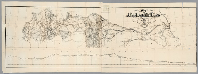
[Union Pacific Railroad, Dodge, G.M.]
Full Title
Map of the Union Pacific Rail Road Surveys of 1864, 65, 66, 67, 1868 from Missouri River to Humboldt Wells Scale 20 miles to 1 inch. G.M. Dodge, Chief Engineer. H. Lambach, del. January 1869. (with profile) Profile Of Grades.
List No
4072.000
Note
Wheat devotes three pages to this map and states "Altogether, this is a fascinating map, particularly to one who has read the annual reports of the Union Pacific engineers, almost always published without illustrative maps." The map shows the route of the railroad from the Missouri river to Humboldt Wells in Nevada (the Central Pacific beat them to this point) and provides great topographic detail on both sides of the route, for distances varying from 40 to 100 miles. A profile of the route appears below the main map. Separately published by the Union Pacific, this is a scarce map. Without color. Scale 20 miles to 1 inch. Relief shown by hachures.
Author
American Photo Lithographic Company
Full Title
The Great Railroad Routes To The Pacific, And Their Connections. 1869. American Photo-Lithographic Company, New York, (Osborne's Process).
List No
4271.000
Note
Shows the proposed routes of the Northern and Southern Pacific Railroads, as well as the just completed Central and Union Pacific lines. Folded. Probably originally in a railroad annual report. Map is without color. Relief shown by hachures. Prime meridians are Washington, D.C. and Greenwich.
Author
California Pacific Railroad
Full Title
Map Showing California Pacific Rail Road Extension And California Pacific Rail Road With Their Connections. 1869. Steam Litho. Britton & Rey, S.F.
List No
5287.000
Note
Map showing progress of California Pacific Rail Road project in color. Includes Table of Distances. Relief shown by hachures.
Author
[California Geological Survey, King, Clarence, Gardner, J.T.]
Full Title
Map of the Yosemite Valley from Surveys made by order of the Commissioners to manage the Yosemite Valley and Mariposa Big Tree Grove by C. King and J.T. Gardner 1865. Drawn by J.T.G.
List No
5905.000
Note
More refined version than that in the 1869 "Yosemite Guide-Book" but less refined than the version in the 1870 "Yosemite Guide-Book", hence our selection of 1869 for the estimated date. The result of a surveys begun in 1863 under the direction of Whitney, the State Geologist. This map is among the most detailed and largest scale maps published of Yosemite during this part of the 19th century, rivaled only by the Wheeler Survey map of Yosemite published in 1883. Because of the folds, this map appears to have been printed as a part of a book, either "The Yosemite Book" or "The Yosemite Guide-Book". This map, all versions of which have the date 1865 printed on the map, is in at least four editions with the most noteworthy aspect being the revision of the rendering of the Valley floor: the first editions had a very inaccurate alignment of the Merced river; this edition of the map is the first to have a good river alignment plus the following features were added: Valley floor redrawn; limited number of Valley structures drawn and labeled including "Ferry", "Leidig's Hotel", "Hutching's Hotel"; "Hutching's Hs." (House), Lamon's Hs."; three orchards; "Ladders Bridge"; "Cap of Liberty"; "Engraved & printed by Julius Bien, N.Y."
Author
Vuillemin, A.
Full Title
Compagnie General Francaise des Chemins de Fer Secondaires ... Department des Deux-Sevres.
List No
8774.213
Note
Loose sheet in atlas. Supplement au Nouveau Journal Financier du 17 Janvier 1892.
Author
Daily Evening Bulletin
Full Title
Map of the Salt Marsh and Tide Lands South of Second Street, in the City and County of San Francisco. (Text Page) Salt Marsh and Tide Lands.
List No
9081.000
1-28 of 28
|


![Covers: سويش بوغازى واطرافلريند خريطه سى [Süveyş boğazı ve etraflarinde harita-sı / Map of the Suez Canal and its Surroundings]](https://www.davidrumsey.com/rumsey/Size2/RUMSEY~8~1/185/10599001.jpg)
![سويش بوغازى واطرافلريند خريطه سى [Süveyş boğazı ve etraflarinde harita-sı / Map of the Suez Canal and its Surroundings]](https://www.davidrumsey.com/rumsey/Size2/RUMSEY~8~1/185/10599002.jpg)