|
Author
Nicholson, W.L.
Full Title
Post Route Map of the States of New Hampshire, Vermont, Massachusetts, Rhode Island, Connecticut and Parts of New York and Maine. By W.L. Nicholson, Topographer of P.O. Department. 1866. (Northern half). 1873
List No
12127.002
Author
Nicholson, W.L.
Full Title
Post Route Map of the States of New Hampshire, Vermont, Massachusetts, Rhode Island, Connecticut and Parts of New York and Maine. By W.L. Nicholson, Topographer of P.O. Department. 1866. (Southern half). 1873
List No
12127.003
Author
Reichspostamt
Full Title
Karte der grossen Postdampfschifflinien im Weltpostverkehr. [Map of the major postal steamship lines in world postal traffic.]
List No
15829.001
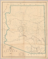
Author
United States. Post Office Department
Full Title
Post Route Map of the State of Arizona 1913.
List No
15729.000
Author
SCHWEIZERISCHEN OBERPOSTDIREKTION
Full Title
Schweizerische Postverwaltung. Übersicht der internen Postverbindungen (mit den ausländischen Anschlüssen). Winterdienst 1902/03. / Administration des Postes suisses. Tableau des Communicators postales internes et des routes étragers correspondants. Service d’hiver 1902/03.
List No
15643.000
Author
United States. Post Office Department
Full Title
Upper Part Post Route Map of the State of New York with Parts of Vermont, Massachusetts, Connecticut, New Jersey, and Pennsylvania. (inset) (Montreal and Vicinity.)
List No
10433.004
Note
Updated to 1879 from 1868. 8 panels. Has letter and list, List Nos. 9394.002 and 9394.003, mounted on the back.
Author
United States. Post Office Department
Full Title
Lower Part Post Route Map of the State of New York with Parts of Vermont, Massachusetts, Connecticut, New Jersey, and Pennsylvania.
List No
10433.006
Note
Updated to 1879 from 1868. 8 panels.
Author
United States. Post Office Department
Full Title
(Composite Map) Post Route Map of the State of New York with Parts of Vermont, Massachusetts, Connecticut, New Jersey, and Pennsylvania.
List No
10433.007
Note
Updated to 1879 from 1868. 8 panels.
Author
United States. Post Office Department
Full Title
Upper Part. Post Route Map of States of Illinois, Iowa and Missouri with Adjacent Parts of Indiana, Wisconsin, Minnesota, Nebraska, Kansas, and Arkansas.
List No
10439.002
Note
Updated to 1879 from 1872. 8 panels.
Author
United States. Post Office Department
Full Title
Lower Part. Post Route Map of States of Illinois, Iowa and Missouri with Adjacent Parts of Indiana, Wisconsin, Minnesota, Nebraska, Kansas, and Arkansas.
List No
10439.004
Note
Updated to 1879 from 1872. 8 panels.
Author
United States. Post Office Department
Full Title
(Composite Map) Post Route Map of States of Illinois, Iowa and Missouri with Adjacent Parts of Indiana, Wisconsin, Minnesota, Nebraska, Kansas, and Arkansas.
List No
10439.005
Note
Updated to 1879 from 1872. 8 panels.
Author
Raffelsperger, Franz, 1793-1861
Full Title
Reise und Influenz-Karte der vorzüglichsten Eil-Post und Brancardwagen Course in dem Oesterreichischen Kaiserstaate.
List No
10167.000
Note
Alexander Johnson: "Extremely rare – 1 of only 2 known examples – of the first edition of Franz Raffelsperger’s highly progressive, stylized geographical time chart of the postal system of the Habsburg Empire and its neighbours. This extremely rare, separately-issued geographical time chart features a brilliant stylized design, decades ahead of its time. Centred on Vienna, it features lines connecting various nodes (cities / major post offices), giving the dispatch and arrival times between each. The sophistication and economy of expression of the work is unlike anything we have seen from the time, even surpassing that of Raffelsperger’s other postal charts. The scope of the chart focuses upon the Hapsburg Empire and its immediate neighbours, its coverage extending as far south as Rome and as far north as Berlin; as far west as St. Gallen, Switzerland and as far east as Lemburg (Lviv, Ukraine). The chart was printed at Raffelsperger’s own costs, although done with the approbation of the Austrian Postal directorate. The present map is the 1st (of 2) editions; the second edition is virtually identical and is dated 1827. The chart is extremely rare in either state. We cannot locate any examples in sales records; in institutional holdings was can trace only 1 example of the present 1st edition (Austrian National Library, Vienna) and 1 example of the 2nd edition (National & University Library of Slovenia - Ljubljana). Franz Raffelsperger (1793 - 1861) [often spelled ‘Raffelsberger’] was one of the most fascinating and underappreciated mapmakers of the 19th Century, responsible for innovative, proto-modernist map designs and unusual printing techniques. That he is not better known today is likely due to the boutique nature of his work; most of his maps were produced in very limited print runs intended for specialists, and so did not gain a mass audience. That being said, his maps were treasured by those who utilized thematic cartography, as well as Austro-Hungarian academics. Raffelsperger was born in Modra, in today’s Slovakia (then part of Hapsburg Hungary). In 1820, he gained employment at the Austrian Postal Directorate in Vienna, where he became fascinated with postal cartography. He was given special access to mapping and information in the directorate’s archives and he proceeded to draft several postal maps, such as the present chart, which were published at his own cost, although the directorate endorsed his work and assisted in their marketing. All of the 1820s issues, such as the present example, are today remarkably rare, as they were produced in only very limited print runs. Importantly, they all tend to feature innovative, proto-modernist designs, decades ahead of their time. In 1835, Raffelsperger began experimenting with different printing methods, especially publishing maps with letterpress. In 1837, he received a privilege for printing maps through this technique. As he did not own a printing shop, he sub-contracted the presses of various Viennese publishers. In 1839, Raffelsperger received a gold medal in Vienna for his industrial achievements, although he continued to produce his maps in a boutique fashion, in limited print runs. In 1841, Raffelsperger published the first edition of this atlas of Austria, Erster Typometrischer Atlas für Geschäftsleute jeder Art, Gymnasien, Schulen und Zeitungsleser. It featured 15 maps of different scales, some of which were printed on two pages. In 1843, he published an atlas of Europe with 24 maps. While Raffelsperger is best known for his separately published maps of the Austrian Empire, showing postal routes and railways, he also published maps of Paris, Budapest and Warsaw. Curiously, he also produced non-cartographic, such as portraits and works of unusual typography, including prints bearing Chinese letters and proofs of oriental scripts. In 1843, Raffelsperger founded his own company, K.K. außerordentlich ausschließlich privilegierte typograph.-geograph. Kunstanstalt (the Emperor’s exclusively privileged typographical-geographical art workshop) in Vienna. However, only a year later he ran into trouble with Viennese book publishers who accused him of creating a “disturbance”, as he was printing not only maps, but also accompanying text, against the regulations of the book printers’ guild. Raffelsperger was compelled to move to Leipzig, Saxony, where he was finally able to operate his enterprise as he saw fit. In addition to maps, he specialized in broadsides and newspapers, including the Der Unpartheiische. Although active as a mapmaker and publisher, Raffelsperger for many years maintained his position at the Austrian Postal Directorate; however, due to a contretemps, he was suspended from his post in 1849, and dismissed in 1851. Latterly, Raffelsperger became something of a recluse and dedicated his time to academic writing and publishing.
Author
[Metzburg, Georg Ignaz von, 1735-1798, Mansfeld, Johann Ernst, 1738-1796]
Full Title
Post-Charte Der Kaiserlich Koniglichen Erblanden. Durch Herrn Abbe Georg, Ignaz Freyherrn von Mezburg Kas. Konigl Professor der Mathematique an der Universitet in Wien gestochen von Mansfeld. Cum Priv. Sac. Caes. Maiest.
List No
11707.000
Note
Engraved postal map of all of the Austrian dominions. This is the "mother" of all the postal maps of the Austrian monarchy, it extends north from Berlin and Warsaw to Rome in the south, from Paris in the west to Bucharest in the east. "The first map of the entire monarchy after more than half a century" (Austria Picta, p. 100). On sheet 105x155.5, dissected into 16 sections 26x39, backed with linen, created by Georg Ignaz Freiherr von Metzburg on the scale of 1: 1,300,000 in 1782. Engraved by Johann Ernst Mansfeld. Shown on this map are 16 post stations on the line between Salzburg and Vienna. Shows postal routes, administrative boundaries, cities, towns, villages, roads and landmarks. Relief shown pictorially. Includes a title cartouche with decorated coat of arms of Austria / Lorraine, an open two- horse carriage passes, and people are sitting in the car. The coachman wears a posthorn that dangles on a belt hanging from his back. The scenes depicted the theme of travel, and the map contributes to the understanding of the history of the postal service by showing the equipment and means of transport of travelers. Symbols show single, one and one half, and double post deliveries which we assume refers to frequency of delivery.
Author
[Gill, Leslie MacDonald, 1884-1947, Great Britain. Royal Mail]
Full Title
Mail steamship routes. MacDonald Gill, 1937. P.R.D. 182.
List No
8175.000
Note
Colorful world map depicts the Mail steamship routes that carried the majority of the UK’s international mail during the 1930s. Commissioned by the General Post Office in 1937. Framed by illustrations of the transport links through which the post would pass. A series of eleven vignettes showing postal and maritime history, the development of sailing vessels from the time of King Alfred to the RMS Queen Mary. Includes new redesign of GPO logo by MacDonald Gill.
Author
United States. Post Office Department
Full Title
Post Route Map of the State of Maine and Adjacent Parts of New Hampshire and Dominion of Canada.
List No
10434.002
Note
Updated to 1879 from 1869. 4 panels.
Author
United States. Post Office Department
Full Title
New Hampshire, Vermont, Massachusetts, Rhode Island, Connecticut and Parts of New York and Maine.
List No
10435.002
Note
Updated to 1879 from 1866. 8 panels.
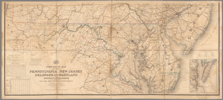
Author
United States. Post Office Department
Full Title
Upper Part Post Route Map of the States of Pennsylvania, New Jersey, Delaware, Maryland and of the District of Columbia.
List No
10436.002
Note
Updated to 1879 from 1869. 8 panels.
Author
United States. Post Office Department
Full Title
Lower Part Post Route Map of the States of Pennsylvania, New Jersey, Delaware, Maryland and of the District of Columbia.
List No
10436.004
Note
Updated to 1879 from 1869. 8 panels.
Author
United States. Post Office Department
Full Title
(Composite Map) Post Route Map of the States of Pennsylvania, New Jersey, Delaware, Maryland and of the District of Columbia.
List No
10436.005
Note
Updated to 1879 from 1869. 8 panels.
Author
United States. Post Office Department
Full Title
Post Route Map of Ohio and Indiana with Adjacent Parts of Pennsylvania, Michigan, Illinois, Kentucky and West Virginia.
List No
10437.002
Note
Updated to 1879 from 1870. 12 panels.
Author
United States. Post Office Department
Full Title
Post Route Map of States of Michigan and Wisconsin with Adjacent Parts of Ohio, Indiana, Illinois, Iowa and Minnesota.
List No
10438.002
Note
Updated to 1879 from 1871. 12 panels.
Author
United States. Post Office Department
Full Title
Post Route Map of State of Minnesota with Adjacent Parts of Iowa, Nebraska, Dakota, Wisconsin and of the British Possessions (Canada).
List No
10440.002
Note
Updated to 1879 from 1876. 12 panels.
Author
United States. Post Office Department
Full Title
Post Route Map of Washington... June 1, 1944.
List No
10887.000
Author
United States. Post Office Department
Full Title
Post route map of the territory of New Mexico : showing Post Offices with the intermediate distances and mail routes in operation on the 1st of June, 1902, also railways under construction June 30th, 1902, and the several mining districts of the territory. The Norris Peters Co. Photo-Litho, Washington, D.C.
List No
11087.000
Note
Color map. Shows administrative boundaries, cities , villages, railroads, roads, electric and cable cars, major postal routes color coded for frequency of delivery, post office, county seats with post offices, Includes lists of the counties in New Mexico territory, key of 116 mining districts and US Post Office Department logo. Forest reserves shown in green.
Author
United States. Post Office Department
Full Title
Post Office Department : Ocean map showing Merchant Marine Act mail routes. Senate Doc. No. 69. 72D Cong., 1st Session. Williams & Heintz Co. Washington, D.C. Exhibit 12 (S. Res. 85).
List No
11088.000
Note
Color map of the service routes and distances in Pacific and Atlantic Oceans. Date estimated. Shows boundaries, cities and towns, Note: "The purple lines shown in the Pacific are not actual boundaries, but enclosed group of islands belonging to the various countries. Includes U.S. Navy Hydrographic Office logo at upper left.
Author
[United States. Post Office Department, Smith, Charles Emory, Von Haake, A.]
Full Title
Post route map of the state of Utah : showing post offices with the intermediate distances on mail routes in operation on the 1st. of December, 1900. Published by order of Postmaster General Charles Emory Smith under the direction of A. von Haake, topographer, P.O. Dept.
List No
11455.000
Note
Color map. Relief shown by hachures.. Shows state and county boundaries, cities, villages, roads, railroads, electric and cable cars. postal routes, delivery schedule, post offices, etc. Includes Explanation to mail services and list of counties in Utah.
Author
Raffelsperger, Franz, 1793-1861
Full Title
Ubersichts Karte der fahrenden Posten in dem Oesterreichischen Kaiserstaate.Entworfen, gezeichnet und herausgegeben von Franz Raffelsperger, bei der K.K. hauptdirection fahrender Posten Wien 1826. In Stein grav. v. Aichinger. (inset) Ubersicht der postrouten.
List No
11850.000
Note
Outline hand colored map of the post routes in Austria with the points showing the easier calculation of the larger distances. Drawn and edited by Franz Raffelsperger. Engraved by Aichinger. Showing administrative boundaries, cities, towns, villages, roads and landmarks, post stations, postal routes and distances. Includes legend, notes and tables: Tarif fur Reisende, die sich der K: K: fahrenden Posten bedienen; Fortsetzung des Tarifes Die Gebuhr bestehl fur die Post. Alex Johnson: "This extremely rare, large format, separately issued, postal map of the Austrian Hapsburg Empire was privately issued by the innovative boutique cartographer Franz Raffelsperger. Importantly, it features a proto-modernist deign, many decades ahead of its time. The map embraces all of the Austrian Empire, which then possessed extensive boundaries, extending from Milan, in the west, to Transylvania, in the east; and from Bohemia, in the north, to Dalmatia, in the south. The map outlines all provinces, and labels major postal centres. The postal routes between the main points are executed in a remarkably progressive manner, with clean stylized lines, crossed to mark the locations of resting stops for the postal carriages. Mileages are noted, while charts and an inset map further detail distances between key points. Curiously, a stylized line extending beyond Transylvania depicts the mail route all the way to Constantinople (Istanbul). A detailed key, lower right, explains the wealth of symbols employed on the map. The present work is predicated on the most advanced information, which Raffelsberger gained due to his employment in the Austrian Postal Directorate. The Austrian Empire then possessed one of the best postal systems in the world and, in addition to its critical role in domestic affairs, provided a critical link between Northern and Mediterranean Europe, and the Near East. While the map was privately issued by Raffelsperger, the note in the lower blank margin claims that it was available for sale from the book-dealer, J.J. Bermann in Vienna, and in the provinces from post offices and many major book shops."
Author
[Karuza, James, Hall, G.H.]
Full Title
Map Showing Territory Served by the San Francisco Post Office.
List No
12098.000
Author
[Walker, Frank C., United States. Post Office Department]
Full Title
United States Foreign air mail : Post Office Department, December 1, 1941. Frank C. Walker, Postmaster General, Smith W. Purdum, Second Assistant Post Master General, John E. Lamiell, Second Assistant Postmaster General, George H. Grayson, Acting director, International postal Service. Map prepared by division of Topography, Bureau of Fourth Assistant Postmaster General.
List No
13010.000
Note
Color map of America. Shows location of delivery and routes to Canada, Central and South America, West Africa, Western Europe, New Zealand, Hong Kong, and Singapore.
Author
[Walker, Frank C., United States. Post Office Department]
Full Title
United States Air mail service: Post Office Department, December 1, 1941. Frank C. Walker, Postmaster General, Smith W. Purdum, Secont Assistant Post Master General, John E. Lamiell, Second Assistant Postmaster General, Roy M. Martin, Superintendent, air Mail Service. Map prepared by division of Topography, Bureau of Fourth Assistant Postmaster General. (insets).
List No
13011.000
Note
Color map of the United States, with with 5 insets: Alaska- Canada; Hawaiian Islands; Trans-Pacific routes; Trans-Atlantic routes; Latin America. Shows domestic and international and service routes to the States, Canada, Central and South America, West Africa, Western Europe, New Zealand, Hong Kong, and Singapore.
Author
Raffelsperger, Franz, 1793-1861
Full Title
Übersichts-Karte der Extrapoststrassen in dem Kaiserthume Osterich : und in einem Theile der angranzendeb lander. Nach den neuesten amtlichen quellen von F. Raffelsperger ... Wien 1829. (on verso) Übersicht der Post -Hauptstrassen in Europa : Nach den neuesten Hilfsquellen verfasst, gezeichnet und herausgegben, von Franz Raffelsperger. Official der k.k. Posthoffbuchaltung. Wien 1834.
List No
13546.002
Note
Outline hand color map of Austria, Showing postal routes.
Author
Raffelsperger, Franz, 1793-1861
Full Title
Ungarn mit Siebenbürgen, Kroatien, Slavonien, Woywodina, Banat, und den Militairgrenzen : mit Angabe der neuen und alten politischen Eintheilungen, aller Postämter, Eisenbahnen und der Orts-Nationalitäten. Herausgegeben vom Geographen Franz Raffelsperger. Ausgeführt und zu haben in dem k. k. a. p. Civil-Geografischen Institute. Wien, und Dr. Zimmermanns Office, in London. Sechste Auslage.
List No
13547.000
Author
United States. Post Office Department
Full Title
Post Route Map of the State of Illinois Showing Post Offices with the Intermediate Distances on Mail Route ... September 1, 1949. (inset) Chicago & Vicinity.
List No
15842.000
Note
A clean copy. Donated to the collection by Mike Ludeman.
Author
United States. Post Office Department
Full Title
Post Route Map of the State of Iowa Showing Post Offices with the Intermediate Distances on Mail Route ... December 1, 1940. (inset) Des Moines & Vicinity.
List No
15843.000
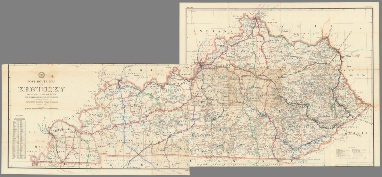
Author
United States. Post Office Department
Full Title
Post Route Map of the State of Kentucky Showing Post Offices with the Intermediate Distances on Mail Route ... January 1, 1942.
List No
15844.000
Note
Donated to the collection by Mike Ludeman.
Author
[United States. Post Office Department, Von Haake, A.]
Full Title
Post Route Map of the State of Maine.
List No
15925.000
Author
[United States. Post Office Department, Work, Hubert]
Full Title
Post route map of the state of Colorado showing post offices with the intermediate distances on mail routes in operation on the 1st of January, 1923. Published by order of Postmaster General Hubert Work. (inset) Denver and vicinity.
List No
6857.000
Note
Rare postal map of the State of Colorado, outline color, showing the post offices and postal routes in the State. The map also shows the routes that receive mail 1 time per week, 2 times per week, 3 times per week and 6 times per week, areas with no post office are noted, as are rural delivery areas, mail messengers, railroads stations, etc. Relief shown by hachures and spot heights. Prime meridian is Greenwich.
Author
[New, Harry S., United States. Post Office Department]
Full Title
Post route map of the state of Washington : showing post offices with the intermediate distances on mail routes in operation on the 1st of December 1925. Published by order of Postmaster General Harry S. New. (insets) Seattle and vicinity. (with) Tacoma and vicinity.
List No
8297.000
Note
Detailed color map. Shows Railroads, roads. cities and towns. Explanation includes: Mail Messengers, frequency of delivery, including once a week, twice a week, three times a week, six times a week and "Special Supply." Discontinued Offices are shown, as are the beginnings and ends of each mail route. Also includes list of counties showing relative position within state and Seal of the Post Office Department. Relief shown by spot heights.
Author
Air France
Full Title
Air France. Reseau Aerien Postal. Printed in France. Reseau Air-France Lignes Etrangeres. (inset) Europe.
List No
8503.000
Author
Ford Motor Company
Full Title
Airway Map of the United States.
List No
9064.000
Author
United States. Post Office Department
Full Title
Domestic & Foreign Air Mail Service. United States Post Office Department. March 1, 1939. (insets) Alaska-Canada. Hawaiian Islands. Trans-Pacific Route. Latin America.
List No
9111.000
Note
Border colored to match air mail designation on letters.
Author
United States. Post Office Department
Full Title
Post Route Map of the State of Oregon Showing Post Offices with the Intermediate Distances on Mail Route ... March, 1928. (inset) Portland & Vicinity.
List No
9127.000
Author
United States. Post Office Department
Full Title
Post Route Map of the State of Ohio Showing Post Offices with the Intermediate Distances on Mail Route ... March 15, 1938. (insets) Toledo & Vicinity. Cleveland & Vicinity. Columbus & Vicinity. Cincinnati & Vicinity.
List No
9128.000
Author
United States. Post Office Department
Full Title
Post Route Map of the State of Michigan Showing Post Offices with the Intermediate Distances on Mail Route ... August, 1924. (inset) Detroit & Vicinity.
List No
9129.000
Author
United States. Post Office Department
Full Title
Post Route Map of the State of Indiana Showing Post Offices with the Intermediate Distances on Mail Route ... January 1, 1938.
List No
9130.000
Author
United States. Post Office Department
Full Title
Post Route Map of the States of New Hampshire and Vermont Showing Post Offices with the Intermediate Distances on Mail Route ... May 1, 1940.
List No
9131.000
Author
United States. Post Office Department
Full Title
Post Route Map of the State of Pennsylvania (Eastern Sheet) Showing Post Offices with the Intermediate Distances on Mail Route ... January, 1922.
List No
9132.001
Author
United States. Post Office Department
Full Title
Post Route Map of the State of Pennsylvania (Western Sheet) Showing Post Offices with the Intermediate Distances on Mail Route ... January, 1922.
List No
9132.002
Author
United States. Post Office Department
Full Title
(Composite Map) Post Route Map of the State of Pennsylvania Showing Post Offices with the Intermediate Distances on Mail Route ... January, 1922.
List No
9132.003
Author
United States. Post Office Department
Full Title
Post Route Map of the State of Illinois Showing Post Offices with the Intermediate Distances on Mail Route ... November, 1926. (inset) Chicago & Vicinity.
List No
9133.000
|


![Karte der grossen Postdampfschifflinien im Weltpostverkehr. [Map of the major postal steamship lines in world postal traffic.]](https://www.davidrumsey.com/rumsey/Size2/RUMSEY~8~1/213/15829001.jpg)