|
REFINE
Browse All : Separate Map and Mining
1-27 of 27
Author
[Gill, Leslie MacDonald, 1884-1947, Empire Marketing Board]
Full Title
A Map of Australia Portraying Her Agricultural Products & Fisheries.
List No
15715.000
Author
Teleshov, L.
Full Title
Skhematicheskaia gornozavodskaia karta zapadnoi i vostochnoi chastei Donetskogo basseina. 1901-1902 [i.e. Schematic Mining Map of Western and Eastern Parts of Donets Basin]
List No
15526.002
Author
Chapin, R. M.
Full Title
Time map (of the Soviet Union) by R. M. Chapin. For report documenting above map see TIME, November 17, 1941 issue.
List No
13582.000
Author
Fine, W.J.
Full Title
Map of the Gunnison Gold Belt Colorado.
List No
10838.001
Author
[Gill, Leslie MacDonald, 1884-1947, Empire Marketing Board]
Full Title
A Map of New Zealand Portraying Her Agricultural Products & Fisheries.
List No
10811.000
Author
[Gill, Leslie MacDonald, 1884-1947, Empire Marketing Board]
Full Title
A Map of the Union of South Africa Portraying Her Agricultural Products & Fisheries.
List No
10779.000
Author
Dagosta, Andy
Full Title
The historic West: Lost mines and ghost towns, frontier military forts. Copyright 1968. Cooper Enterprises. Scottsdale, Arizona. Drawn by Andy Dagosta.
List No
13091.000
Note
Pictorial map of the U. S. West. Shows historical notes, Ghost towns, old mines, military posts, old mines, missions, Native American settlements, rivers cities and towns. Relief shown by shading and hachures.
Author
Great Northern Iron Ore Properties (Firm : Saint Paul, Minn.)
Full Title
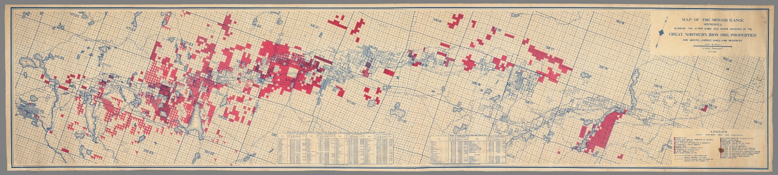
Map of the Mesabi Range, Minnesota, showing the active mines and other holdings of the Great Northern Iron Ore Properties, and other miscellaneous mines and reserves. St. Paul Minnesota, May 31, 1928.
List No
13034.000
Note
Rolled color map mounted on linen. Shows land ownership, railroads, roads rivers and lakes. Includes legend and index charts to mines of Great Northern and to mines of other companies. The Mesabi Iron Range is an elongate trend containing large deposits of iron ore, and the largest of four major iron ranges in the region collectively known as the Iron Range of Minnesota. Discovered in 1866, it is the chief iron ore mining district in the United States.
Author
Rose, W.
Full Title
W. Rose's revised chart of the Comstock mines and Sutro Tunnel, State of Nevada. Compiled & Drawn by W. Rose. Published by Payot, Upham & Co., San Francisco. A. Waldstein, Lith. S.F. Entered According Act of Congress in the Year 1878 ... Washington, D.C. (inset profile view) Sutro Tunne. (with view) The Mouth of Sutro Tunnel.
List No
13018.000
Note
Revised map of part of Nevada. Representing Comstock mines and the position of the Sutro Tunnel and the counties surrounding it. Shows mining claims, location of mineral veins, counties, roads, flumes, railroad, Indian reservations, and the Sutro Tunnel. Towns or settlements of Silver City, American Flat, Gold Hill Town, Virginia City, and Flowery Ridge. Includes small vignettes of buildings, structures, and mountain peaks. Relief shown pictorially. The Comstock Lode, a huge vein of silver discovered in 1857 under Nevada’s Mount Davidson, was the greatest precious-metal discovery since gold was found in California in 1848. Sutro Tunnel, conceived by German engineer Adolph Sutro (1830-98) as a means of draining off the huge quantities of water infiltrating the ever-deeper shafts. Constructed under Sutro’s leadership between 1869 and 1878, the tunnel extended several miles from Mount Davidson to its exit on a piece of land granted to Sutro in the vicinity of Dayton.
Author
[Firket, Adolphe Georges Auguste, Jochams, Felix]
Full Title
Carte de la production, de la circulation, de la consommation des minerais et de la production des metaux en Belgique pendant l'annee 1878. Dressee a l'aide de documents officiels et de renseignements speciaux recueillis par M. F. Jochams, inspecteur - general de mines, par Adolphe Firket .... Institut Cartographique Militaire 1881.
List No
11709.001
Note
Color map of Belgium 73x87, dissected into 24 sections of 18x14, backed with linen. Showing production, circulation, consumption of minerals and the production of metals in Belgium during 1878. Includes color coded signs showing production, consumption and transportation of minerals, and Table of mines, minerals, factories and production of iron, zinc, lead, copper or pyrite minerals in 1878. Map showing cities, villages, roads, railroads, rivers, canals, etc. Includes legend and text. This flow diagram was likely influenced by the work of Charles Joseph Minard.
Author
Guillemin-Tarayre, Edmond
Full Title
Carte Panoramique de la Region metallifere de Washoe (Etat de Nevada) par E. Guillemin-Tarayre. Cette carte est executee en projection gnomonique sur l'horizon du Mt. Davidson. Grave chex Erhard, Paris - Impr. Lemercier r. de Seine 57.
List No
11309.000
Note
Early map of Lake Tahoe and the Washoe Mining District on a Gnomonic Projection. One of the earliest geological and mining map of the region. Centered on Virginia City and extending to the Truckee River, Lake Tahoe, the Walker River and the Carson River. The outer ring of mountains locates Sevier Mountain, Pyramid Peak, Mt. Washoe, the Valley of the Carson River, and "Massif Palmyra." Towns named on the map include Washoe City, Fort Churchill, Genoa, Carson, with several dozen mines also named. Relief shown pictorially, by hachures and spot heights. Includes key to geological formation and notes. Guillemin-Tarayre's map is part of a rare set of scientific works published by the French government.
Author
[Vischer, Edward, Cooper, J.J.]
Full Title
(Text Page) Panorama from the Summit of Mount Davidson, Washoe Range.
List No
8715.001
Note
Informative text as to how the map came to be created and an explanation of the visible area.
Author
[Vischer, Edward, Cooper, J.J.]
Full Title
Panorama from the Summit of Mount Davidson, Washoe Range.
List No
8715.002
Note
Unusual 360 degree perspective bird's eye view as seen from summit of Mount Davidson, the site of the famous Comstock Mines and Virginia City in Nevada. Attractive vignettes of mining camps.
Author
[Perry, Charles E., O'Farrell, T.P.]
Full Title
Perry's mining map of the southern dist. West Kootenay. First Edition. C.E. Perry & Co. Civil and Mining engineers, Nelson, B.C. March 1893. Copyright 1893, by Rand Mc Nally & Co. Compiled and drawn by T.P. O'Farell, Nelson, B.C. (insets) Trail Creek mining camp. -- Scale [ca. 1:48,000]. (with) Ainsworth mining camp. -- Scale [ca. 1:63,360]. (with) Kaslo-Slocan mining camp. -- Scale [ca. 1:126,720]. (with) Nelson mining camp. -- Scale [ca. 1:63,360]. (with) "Our position on the planet" [western hemisphere].
List No
8020.000
Note
One of the earliest printed map of the entire Southern District to focus on the Kootenay mining regions. With inset maps of the major mining regions, smaller maps presenting a detailed topographical features. Relief shown by hachures. Shows roads, trails, railways, telegraph lines, towns, mining camps, claims, steamship lines, etc. General References; Slocan Numerical Reference; compasses for Slocan and Nelson.
Author
Amerine, C.H.
Full Title
C.H. Amerine's : Sectional map of Washington, Oregon, Idaho, and western Montana. Compiled from latest official data exploration and other sources. Compiled and published by C.H. Amerine, 1891. Copyrighted by C.H. Amerine, Tacoma, Wash. Photo - Litho by Schmidt Lable & Lith Co. S.F.
List No
6744.000
Note
Amerine published several maps of Washington, Oregon, Puget Sound and other areas of the Pacific Northwest, but this is his only multi-state map that we know of and it is not held in any libraries listed in WorldCat. Full color map, backed with linen. Shows capitals, county, towns, wagon roads, railroads, trails, reservations, light houses, blocks, subdivisions, etc. Includes explanation and table of township subdivision. Relief shown by hachures. Prime meridian is Washington.
Author
Haack, Herman
Full Title
Deutsche Demokratische Republik, Bergbau u. industrie. Arbeitskreis Dr. H. Haak. VEB Hermann Haack, Geographisch Kartographische Anstalt Gotha. (Cover title) Wirtschafts karte : Deutsche Demokratische Republik. MDI d. DDR nr. 7579/62.
List No
11156.002
Note
Color map of East Germany, 115x79.5, folded into 30x21. Showing the economic production and industry during 1960s. List on the lower right corner identifies types of minerals and types of industries by pictorial symbols. Map shows industrial towns, railways, rivers, canals, ferries and international boundaries. Includes list of major cities.
Author
Clason, George S.
Full Title
Clason's industrial map of Arizona. Published by Clason Map Co., Denver, Colorado. Copyright 1908 by Clason, George S. Mineral features by Cyrus Fisher Tolman.
List No
13042.000
Note
Color map of Arizona, dissected and mounted on linen, folded into brown marbled covers to 27x13. Shows mining districts, mineral features, irrigated lands, National forest, Indian reservations, county boundaries, railroads and roads. Includes legend, indexes to mineral features, list of cities and towns and fish and game laws. Relief shown by hachures.
Author
Wyld, James
Full Title
Map of Australia, compiled from the nautical surveys, made by order of The Admiralty, and other authentic documents. By James Wyld, Geographer to the Queen. London: Published by James Wyld, Charing Cross East.
List No
13484.000
Author
[Blackmar, Chas. A., (California) State Mining Bureau]
Full Title
Map of Los Angeles city oil field, Los Angeles County, California, by Chas. A. Blackmar. Issued by the State Mining Bureau, Ferry Building, San Francisco, Lewis E. Aubury State Mineralogist. Trustees: Wm. C. Ralston, President ...
List No
14043.000
Note
Shows early oil fields in Los Angeles. Printed on paper, in black, with title cartouche in red. Includes a key indicating wells, pumping plants, etc. Map 43 x 62 cm, on sheet 54 x 72 cm. (Date estimated, based upon Wm. C. Ralston's death in 1875; Ralston listed as President of the State Mining Bureau.) (See Pub List No. 3336.000 for other copy.)
Author
Fremont, J.C.
Full Title
Las Mariposas Estate Mariposas County California. Containing 44,386 83/100 Acres Or 70 Square Miles. Lith of Sarony, Major & Knapp, 449 Broadway, N.Y. Max Strobel Engineer.
List No
2624.000
Note
Map to accompany a 63 page pamphlet promotion. Date estimated. Fremont published the map and pamphlet (pamphlet not included here) to raise money for his estate. He failed, and lost the estate to the creditors. Streeter: "It is the best map of the country about Mariposas I have yet seen." Peters mentions the map appearing in a book by The Mariposas Company in 1863. Full color.
Author
New York and Silver Peak Mining Company
Full Title
Map Of Nevada Showing the location Of The New Discoveries Of Silver Peak. 1865. R.C. Root, Anthony & Co. 21 Nassau St. N.Y. (inset) Diagram Of Silver Peak.
List No
3758.000
Note
Map shows Northern Nevada and Northern California, with an inset diagram of Silver Peak. Silver Peak was an important discovery southeast of Aurora. The map is accompanied by a ms letter dated Nov. 13, 1865, from an F.E. Goodsell to the New York and Silver Peak Mining Company tendering five hundred dollars for twenty shares of the company's stock. The map was probably originally in a brochure describing the stock offering. Relief shown by hachures.
Author
Wescoatt, N.
Full Title
Map Of Gold Hill Front Lodes On The Comstock Range N.T. Surveyed July 1864. By N. Wescoatt, C.E. Located Sept. & Oct. 1859. Made to accompany Report of Dr. J.A. Veatch. Attenh. N. Wescoatt. C.E. Oakley & Tompson Lith. 46 Water St. Boston.
List No
5297.000
Note
Map is without color. Shows locations of tunnels and mine shafts. Relief shown by hachures. Scale 375 ft. to 1 in.
Author
Stanford's Geographical Establishment
Full Title
Topographical Map Showing the Locations of the Sutro Tunnel And The Comstock Lode State Of Nevada, United States Of America. Reduced and Compiled from U. States Govt. Surveys &c. at Stanford's Geographical Estabt. London, June, 1873. (with) Profile Of Sutro Tunnel ... Lithographed at Stanford's Geogl. Estabt., London. (with) Longitudinal Section Of The Comstock Lode, Shewing The Workings And Their Relative Depths, To The Sutro Tunnel.
List No
5303.001
Note
Color map measuring 42x32.5, with two profiles on one sheet. Relief shown by contour lines.
Author
Read, T.J.
Full Title
Map Of The Golden Rule And Adjacent Mines, Eureka District, Nevada. Drawn By T.J. Read, Supt. Eureka Con. & Deputy U.S. Surveyer. Empire Lith. & Engr. Co. 243-247 Pearl St. N.Y.
List No
5316.000
Note
The Golden Rule Mines are tinted pink and labeled "Golden Rule" Shows boundaries of mining claims, locations of tunnels and mine shafts. Relief shown by hachures.
Author
Tassin, J. B.
Full Title
A newly constructed and improved map of the state of California. Shewing the extent and boundary of the different counties according to an Act passed by the Legislature April 25th, 1851. With a corrected and improved delineation of the gold region compiled from the best and most recent surveys by J.B. Tassin. Lith. by Pollard & Peregoy -- Published by Cooke and Lecount, San Francisco. Entered according to Act of Congress in the year 1851 by J.B. Tassin ... Northern District of the state of California.
List No
5651.000
Note
Relief shown by hachures and spot heights. Shows drainage, counties, roads, etc. Covers also Nevada. Wheat Gold states it shows many more mining camps than any of the 1850 maps and "It is quite similar to Butler but discloses somewhat better workmanship."
Author
Loader, T. B.
Full Title
Under the patronage of His Majesty, T.B. Loader's scientific and commercial map of England and Wales in which are delineated the canals, rail-roads, & navigable rivers : the extent of the navigation of each river, with the elevations of the canals, together with the geology, and principal situations of the mineral productions. 1834. Published by T.B. Loader, 31 Bedford, St. Covent Garden. Mounted & colored by G. Cross, 98 Dean St. Soho.
List No
6887.000
Note
Color map, dissected and mounted on cloth ; 128 x 103, folded to 23 x 14. Shows rivers, canals, railroads, lighthouses, and roads. Includes geological references and ores, and explanation.
Author
News Map of the Week Inc.
Full Title
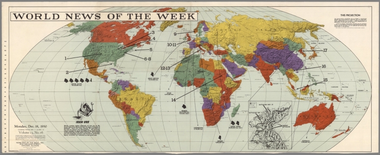
World news of the week. Monday, Dec. 18, 1950 : Covering period Dec. 8 to Dec. 14 Volume 13, No. 16. Published and copyrighted, 1950, by News Map of the Week, Inc. 1512 Orlens Street, Chicago, Illinois. Published in two section. Section one. A member of the United Press Associations. Lithographed in U.S.A. (with inset map of Korea).
List No
8279.000
Note
Color lithograph map of the world. Inset: untitled black and white map of Korea, showing battle lines, airfields, roads and railways, Includes notes on projection, Iron Ore production in the world and text:"Single copy price when accompanied by cash $1.00". Shows countries and major cities. Relief shown by shadings.
1-27 of 27
|

![Skhematicheskaia gornozavodskaia karta zapadnoi i vostochnoi chastei Donetskogo basseina. 1901-1902 [i.e. Schematic Mining Map of Western and Eastern Parts of Donets Basin]](https://www.davidrumsey.com/rumsey/Size1/RUMSEY~8~1/205/15526002.jpg)