|
REFINE
Browse All : Separate Map and Military of Pacific
1-26 of 26
Author
[United States. Army Service Forces. Army Information Branch., Harrison, Richard Edes]
Full Title
Newsmap For the Armed Forces. 276th Week of the War - 158th Week of U.S. Participation.
List No
15947.001
Note
Duplicate of 9014.000 but with mailing envelope added.
Author
Ogawa, Hikohei 小川彦平
Full Title
[Map of the Pacific. With a Detailed View of New Guinea and the Solomons] 太平洋周域地圖: 附ニューギニア東部及ソロモン諸島要圖 統撰. [Taiheiyō Shū-iki chizu: Fu nyūginia tōbu you Soromon shotō yōzu. Osamu sen].
List No
15085.002
Author
Ogawa, Hikohei 小川彦平
Full Title
(Blank map of the Western Pacific)
List No
15085.003
Note
Blank map for users to fill in details of the ongoing war.
Author
Harrison, Richard Edes
Full Title
The physical world to the west. Richard Edes Harrison. Supplement to Fortune, January 1942, Copr. 1941 Time Inc.
List No
13491.001
Author
[Burke, Howard, Los Angeles Examiner]
Full Title
Japan and Russia Will Divide China. Signs Increase That Northern Area and Lower Yangtze Basin Will be Carved Into Puppet States by Stalin and Mikado, Leaving South Largely at Mercy of Both. March of events : Screen and drama. Milwaukee News Sentinel : Sunday, April 28, 1940. Map copyrighted 1940 by Los Angeles Examiner.
List No
11885.000
Note
Pictorial map from the Milwaukee News-Sentinel March of Events section. Illustrated by Los Angeles Examiner artist Howard Burke covering the area China, Japan, Southern Russia and the northern part of French Indochina and Siam, showing how the "Aggressors Divide China." Map showing naval and air bases, areas under Japanese occupation are shown in red. Also showing cities, rivers, roads, mountains, agricultural products and raw materials. Includes text, text labels and and dated events providing an effective overview of the geopolitical situation.
Author
[Manning, F. E., Kaltenborn, H. V., Pure Oil Company.]
Full Title
Global war in the Pacific, to show progress and latest advances of the allies ... Copyright 1944, the Pure Oil Company. All maps designed and executed by F.E. Manning. (insets) View of Pacific showing territories and possessions of warning nations ... December 7, 1941. (with) View of Pacific showing Tokyo as the central target. (cover title) Pacific War maps. Edited by H v Kaltenborn ...
List No
11572.002
Note
Color map on 1 sheet 99x128, folded. Includes 2 inset maps. Showing naval and air bases, roads, railroads rivers, mountains and distances. Relief shown by shadings; depth shown by bathymetric tints.
Author
Baltimore American
Full Title
Pacific Rule Threatens Peace. (insets) Manila Bay. Oahu.
List No
12320.000
Author
Burke, Howard
Full Title
The Pacific - Vital area for United States and Japan. Los Angels Examiner ... November 1942. Howard Burke. (inset) Palau Islands.
List No
8066.000
Note
Color pictorial map, mounted on Japanese paper. With inset at lower right corner. Showing Greater East Asia and Pacific Islands with air and naval Bases. Text box at lower left note" The war in the Pacific opened with the sneak attack on Pearl Harbor ...". Relief shown pictorially. Informative text labels and small pictographs provide an effective overview of the geopolitical situation, in keeping with the "air-age" .
Author
[Los Angeles Times, Owens, Charles H.]
Full Title
Saipan conquest sets pattern for vast aerial operations. Los Angeles Times. Monday July 10, 1944.
List No
8067.000
Note
Color pictorial map by Charles Owens, mounted on Japanese paper. Showing the war in the Pacific. The capture of the strategic island of Saipan is illustrated, with a description in the text at upper right: "American conquest of Saipan in the Marianas has completed a pattern for aerial operations of overwhelming dimensions. Military experts envisage bombing flights, principally those of the new B-29 Superfortresses, originating from Saipan and ranging as far as Japan, Formosa, the China coast and the Philippines." Also shows that range, with other centers of aerial operation: the Admiralty Islands north of New Guinea and Chungking in China. Informative text labels provide an effective overview of the geopolitical situation, in keeping with the "air-age". "Red tint indicates Jap held areas".
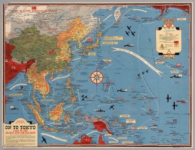
Author
[Turner, Stanley, Petersen, C.C.]
Full Title
Dated Events. On To Tokyo. Map of the Pacific and the Far East. Stanley Turner, 44. Copyright, Canada and U.S.A., 1944, C.C. Petersen, Publishing and Advertising, Toronto, Canada. Seventh Edition.
List No
6828.000
Note
Color map, seventh edition, showing the latest activity in the Pacific Arena. On sheet 51x 66, folded as issued. Date of 1944 in marker at lower left corner. Note below title: "With this invasion map you will be able to follow the progress of the Allied armies on their way to smash Japan ..." Legend includes: American, British, Russian and Japanese Naval Bases are shown; land areas are colored to show countries under Anglo-American control, those retaken from Japan, and those under Japanese control. A fascinating map packed with information on battle dates and illustrations. Relief shown pictorially. From the collection of John Oram.
Author
[Los Angeles Times, Owens, Charles H.]
Full Title
Rabaul threatened as Yanks March through New Georgia. Los Angeles Times Monday July 12, 1943.
List No
11011.000
Note
Color map with detailed view of the action in New Georgia Group, Solomon Islands. Shows boundaries, major cities, battle fields, battleships, and war planes. Relief shown pictorially and by spot heights. Includes notes and text: "The combined allied land, sea and air forces have struck again in the Solomons ..."
Author
[Manning, F. E., Kaltenborn, H. V., Pure Oil Company.]
Full Title
Southeast Asia (Scale: ca. 1:5,500,000). Japan (Scale: ca. 2,450,000). Northeast China and Japan (Scale: ca. 1:5,300,000). Philippines (Scale: ca. 5,500,000). (inset diagram). All maps designed and executed by F.E. Manning. (cover title) Pacific War maps. Edited by H v Kaltenborn ...
List No
11572.003
Note
4 color maps on 1 sheet, folded. With inset diagram. Showing naval and air bases, roads, railroads rivers, mountains and distances. Relief shown by shadings; depth shown by bathymetric tints.
Author
[Harrison, Richard Edes, Army Orientation Course. Special Service Division Army Service Forces]
Full Title
The War Fronts. Newsmap. Monday, December 27, 1943. ... Vol. II No. 36. Prepared and Distributed by the Army Orientation Course. Morale Services Division, Army Service Forces, War Dept.,2E581 Pentagon Bldg., Washington D.C. U.S. Government Printing Office: 1943 - 538110.
List No
12026.002
Note
Shows extent of the Japanese Empire.
Author
[Turner, Stanley, Petersen, C.C.]
Full Title
Young America Pacific Theatre War Map. Distributed in Schools as a Teacher Service by Young America for National Newsweekly for Youth ... New York.
List No
12076.001
Note
Date estimated based on text.
Author
[Turner, Stanley, Petersen, C.C.]
Full Title
(Text Page) Young America.
List No
12076.002
Note
Date estimated based on text.
Author
[Dickerhoff Jr., S.C., Yorklish, Paul]
Full Title
World War II - 1941-1945 - Asiatic - Pacific Operations. Copyright 1946 by S.C. Dickerhoff, Jr. - World War Chart Co. Lebanon, Penna. Paul Yorklish, 1-28-46.
List No
12192.000
Author
Anonymous
Full Title
Guide to the Western Pacific.
List No
12343.000
Note
Date estimated.
Author
Turner, Stanley
Full Title
(WWII Pacific theaters of War). War in Europe Dated Events. Stanley Turner. Printed in U.S.A. International circulation Company, Inc., New York City. Copyright, Canada and U.S.A. 1944, C.C. Peterson, publishing and advertising, Toronto, ONT.
List No
13579.002
Author
[Manning, F.E., Army Orientation Course, Special Service Division Army Service Forces]
Full Title
Target Tokyo. Newsmap. Monday, October 18, 1943. ... Vol. II No. 26. Prepared and Distributed by the Army Orientation Course. Special Service Division Army Service Forces, War Dept.,2E581 Pentagon Bldg., Washington D.C. U.S. Government Printing Office: 1943 - 538110.
List No
6769.001
Note
Shaded relief map centered on Tokyo, Japan. Has a cut-away scale for measuring distances from Tokyo or, alternatively one can use the concentric rings. Some flight routes and mileages shown. Hemispherical view.
Author
[Turner, Stanley, Petersen, C.C.]
Full Title
(War map of Pacific Ocean area). Allyn and Bacon : Publishers of the Stull - Hatch Global Geographies. (on verso) Dated events, World War map by Stanley Turner. Dated events, World War map, by Stanley Turner A.R.C.A. Allyn and Bacon : Publishers of the Stull - Hatch Global Geographies. (insets) Western hemisphere. (with) Part of the Eastern hemisphere. (with) Africa.
List No
8237.002
Note
untitled black and white map of Pacific naval operations (scale ca. 1:34,000,000). Maps Include naval bases: British, U.S.A., Russian, Jap., text, historical and chronological notes pertaining to World War II. Shows cities, industry, agriculture, forests, etc.
Author
Hagstrom Company Incorporated
Full Title
Hagstrom's Map of the Aleutian Islands, Alaska, Southwest Pacific, Europe, Mediterranean, North Africa.
List No
8911.002
Author
Hagstrom Company Incorporated
Full Title
Follow the War with Hagstrom's Map of the World.
List No
8911.003
Author
C.P.D.
Full Title
Pacific Battlefront. (inset) Kawajalien Atoll.
List No
8915.000
Note
Date from Indian postmark on back.
Author
LeNoir
Full Title
Progressive Naval War Map of the Pacific War Operations.
List No
9743.002
Author
Turner, Stanley
Full Title
(Map of the Pacific War Fronts Dated Events. 1943.)
List No
9771.002
Author
Turner, Stanley
Full Title
(Map of the Pacific War Fronts Dated Events. 1944.)
List No
9794.002
Note
Includes a panel stating, "Allyn and Bacon, Publishers of the Stull-Hatch Global Geographies".
1-26 of 26
|

![[Map of the Pacific. With a Detailed View of New Guinea and the Solomons] 太平洋周域地圖: 附ニューギニア東部及ソロモン諸島要圖 統撰. [Taiheiyō Shū-iki chizu: Fu nyūginia tōbu you Soromon shotō yōzu. Osamu sen].](https://www.davidrumsey.com/rumsey/Size2/RUMSEY~8~1/199/15085002.jpg)