|
REFINE
Browse All : Separate Map of Yosemite National Park
1-42 of 42
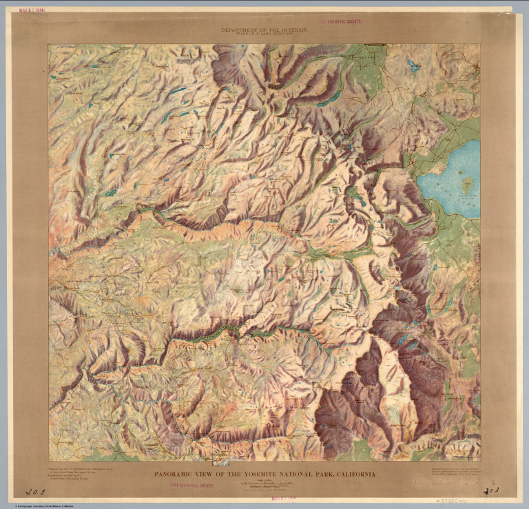
USGS (U.S. Geological Survey); Renshaw, ... Panoramic View of the Yosemite National ... 1914 6923.000 Related Author
[USGS (U.S. Geological Survey), Renshawe, John H.]
Full Title
Panoramic View of the Yosemite National Park, California.
List No
6923.000
Note
Date estimated. Shaded relief without contours. Full color artistic rendering of the park. Part of a series for the national parks.
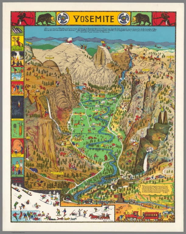
Author
Mora, Jo (1876-1947)
Full Title
Yosemite. Copyright 1931. Jo Mora.
List No
10030.000
Note
Same as our other 1949 issue but printed with brighter colors. Second color issue, after the 1941 first color. Remarkably cute vignettes on a birdseye view of Yosemite Valley and vicinity. For more information on Jo Mora's life and works, see http://www.jomoratrust.com
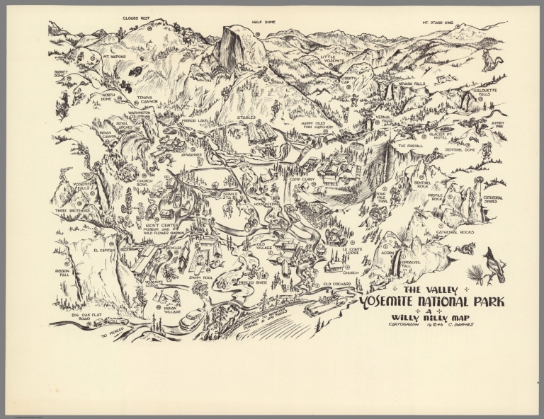
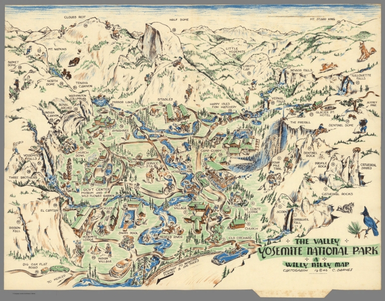
Author
Barnes, Carroll
Full Title
The Valley, Yosemite National Park. A Willy Nilly Map. Cartograph 1946. C. Brarnes. (on verso) This High Sierra country surrounds Yosemite Valley. (with) Yosemite Valley Boasting chart.
List No
11256.002
Note
A whimsical 1946 pictorial map of the Yosemite National Park, California. Made to be fold twice and sent through the mail. When folded the map can be addressed, stamped and sent a through the mail. Map showing several landmarks and places of interest, including Half Dome, Clouds Rest, Little Yosemite, Indian Village, wildlife, recreational facilities, roads and trails. The reverse side of the map is printed with a Boasting Chart of 47 places and things to do and see corresponding to numbers on the map and a map of the High Sierra country surrounding the Yosemite Valley, with 35 corresponding to numbers on the map.
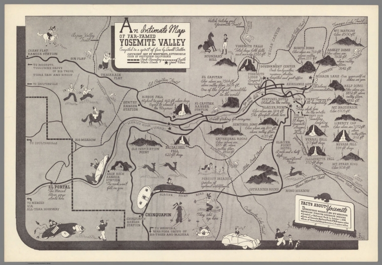
Butler, Lowell; Westways Magazine An intimate map of far-famed Yosemite Va... 1937 11600.000 Related Author
[Butler, Lowell, Westways Magazine]
Full Title
An intimate map of far-famed Yosemite Valley : Compiled in a spirit of fun by Lowell Butler. Copyright 1937 by Westways, the Automobile Club of Southern California.
List No
11600.000
Note
Pictorial map of the Yosemite Valley, prepared for the Westways Magazine of the Southern California Automobile Club. Shows parks boundaries, roads, trails, recreation areas and places of interest. Relief shown pictorially and by spot heights. Includes notations "Facts about Yosemite". Lowell Butler illustrated pictorial maps for publications of the Automobile Club of Southern California. This map seems to be one of the earliest recorded map by Butler.
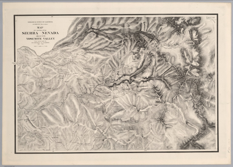
Whitney, J.D.; Gardner, J.T.; Hoffmann, ... A Portion of the Sierra Nevada adjacent ... 1870 4650.000 Related Author
[California Geological Survey, Whitney, J.D., Gardner, J.T., Hoffmann, Chs. F.]
Full Title
Map of a Portion of the Sierra Nevada adjacent to Yosemite Valley, from surveys made by Chs. F. Hoffmann and J.T. Gardner, 1863 -1867. Geological Survey of California, J.D. Whitney, State Geologist. J. Bien, Lith. N.Y.
List No
4650.000
Note
Date based upon the 1870 publication date of the Guide-Book volume with a map of the same content, our Image No. 5901004. Relief shown by hachures. Flat map on heavy paper in mylar. Much content added to map and a little removed from 1869 edition of Guide-Book map, our Image No. 4212020. A few examples of additions: "Hopkins" (by Clouds Rest), "Lake May", "Cathedral Creek" drainage, "Peregoy's", "Harden Lake", "Hite's Cove", "Hennessy's", and many roads. Among items removed: "Hog Ranch", "Wilsons", one of the routes running northeast from Tenaya Lake, and "Milk Ranch" (relabeled "Mill Ranch").
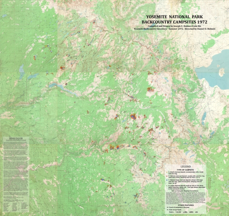
Author
Holmes, Joseph Edward
Full Title
Distribution of Campfire Rings in the Backcountry Wilderness of Yosemite National Park, California, 1972.
List No
5787.000
Note
Hand drawn annotations on twelve U. S. Geological Survey 15-minute topographical basemaps. A series of symbols represent the different sizes of about 4500 fire rings and corresponding trampled areas. Plotting of fire rings follows a complex protocol. Detailed explanatory legend. Original in the Yosemite National Park Archives.
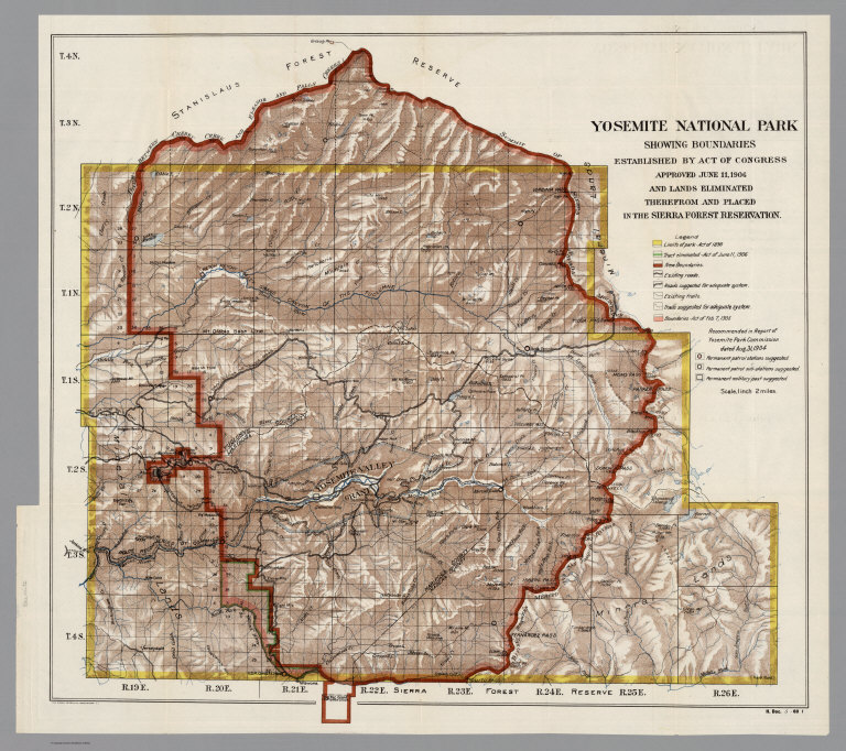
Author
The Norris Peters Co.
Full Title
Yosemite National Park, showing boundaries established by act of Congress : approved June 11, 1906, and lands eliminated therefrom and placed in the Sierra Forest Reservation. The Norris Peters Co., Washington D.C.
List No
5871.000
Note
Full color map. Relief shown by shading and spot heights. Legend shows: Limit of park, Park boundaries, roads and tracts in color. Includes patrol stations and military posts: Recommended in report of Yosemite Park Commission dated Aug. 31, 1904. On the right lower corner of the map: H. Doc. 5-60 .I
Author
USGS (U.S. Geological Survey)
Full Title
Big Trees, Calif.
List No
6203.000
Note
Edition of 1891, reprinted. 30-minute topographic quadrangle with relief shown as contours. Includes area of Columbia.
Author
USGS (U.S. Geological Survey)
Full Title
Big Trees, Calif.
List No
6204.000
Note
Edition of 1901, reprinted 1937. 30-minute topographic quadrangle with relief shown as contours. Includes area of Columbia.
Author
USGS (U.S. Geological Survey)
Full Title
Bridgeport, Cal.-Nev.
List No
6205.000
Note
Edition of 1909, reprinted. 30-minute topographic quadrangle with relief shown as contours. Includes areas of Mono Lake, Sweetwater Mountains.
Author
USGS (U.S. Geological Survey)
Full Title
Bridgeport, Cal.-Nev.
List No
6206.000
Note
Edition of 1911, reprinted 1933. 30-minute topographic quadrangle with relief shown as contours. Includes areas of Mono Lake, Sweetwater Mountains.
Author
USGS (U.S. Geological Survey)
Full Title
Bridgeport, Cal.-Nev.
List No
6207.000
Note
Edition of 1911, reprinted 1939. 30-minute topographic quadrangle with relief shown as contours. Includes areas of Mono Lake, Sweetwater Mountains.
Author
USGS (U.S. Geological Survey)
Full Title
Bridgeport, Cal.-Nev.
List No
6208.000
Note
Edition of 1911, reprinted 1951. 30-minute topographic quadrangle with relief shown as contours. Includes areas of Mono Lake, Sweetwater Mountains.
Author
USGS (U.S. Geological Survey)
Full Title
Dardanelles, Calif.
List No
6209.000
Note
Edition of 1896. 30-minute topographic quadrangle with relief shown as contours. Includes areas of Yosemite National Park, Sonora Pass, Stanislaus River.
Author
USGS (U.S. Geological Survey)
Full Title
Dardanelles, Calif.
List No
6210.000
Note
Edition of 1896, reprinted 1902. 30-minute topographic quadrangle with relief shown as contours. Includes areas of Yosemite National Park, Sonora Pass, Stanislaus River.
Author
USGS (U.S. Geological Survey)
Full Title
Dardanelles, Calif.
List No
6211.000
Note
Edition of 1896, reprinted 1907. 30-minute topographic quadrangle with relief shown as contours. Includes areas of Yosemite National Park, Sonora Pass, Stanislaus River.
Author
USGS (U.S. Geological Survey)
Full Title
Dardanelles, Calif.
List No
6212.000
Note
Edition of 1896, reprinted 1912. 30-minute topographic quadrangle with relief shown as contours. Includes areas of Yosemite National Park, Sonora Pass, Stanislaus River.
Author
USGS (U.S. Geological Survey)
Full Title
Dardanelles, Calif.
List No
6213.000
Note
Edition of 1898, reprinted 1924. 30-minute topographic quadrangle with relief shown as contours. Includes areas of Yosemite National Park, Sonora Pass, Stanislaus River.
Author
USGS (U.S. Geological Survey)
Full Title
Dardanelles, Calif.
List No
6214.000
Note
Edition of 1898, reprinted 1934. 30-minute topographic quadrangle with relief shown as contours. Includes areas of Yosemite National Park, Sonora Pass, Stanislaus River.
Author
USGS (U.S. Geological Survey)
Full Title
Dardanelles, Calif.
List No
6215.000
Note
Edition of 1898, reprinted 1947. 30-minute topographic quadrangle with relief shown as contours. Includes areas of Yosemite National Park, Sonora Pass, Stanislaus River.
Author
USGS (U.S. Geological Survey)
Full Title
Hawthorne, Calif.-Nev.
List No
6217.000
Note
Edition of 1911, reprinted 1944. 30-minute topographic quadrangle with relief shown as contours. Includes areas of Tonopah Junction, Mono Lake, Walker Lake, Hawthorne.
Author
USGS (U.S. Geological Survey)
Full Title
Mariposa, Calif.
List No
6218.000
Note
Edition of 1912, reprinted 1951. 30-minute topographic quadrangle with relief shown as contours. Includes areas of Coarse Gold, San Joaquin River, Grub Gulch, Yosemite National Park.
Author
USGS (U.S. Geological Survey)
Full Title
Mt. Lyell, Calif.
List No
6219.000
Note
Edition of 1901, reprinted 1914. 30-minute topographic quadrangle with relief shown as contours. Includes areas of Mono Lake, Yosemite National Park, Devils Postpile National Monument, Merced River.
Author
[USGS (U.S. Geological Survey), Funk & Wagnalls Company.]
Full Title
Mt. Lyell, Calif.
List No
6220.000
Note
Edition of 1901, reprinted 1929. 30-minute topographic quadrangle with relief shown as contours. Includes areas of Mono Lake, Yosemite National Park, Devils Postpile National Monument, Merced River.
Author
USGS (U.S. Geological Survey)
Full Title
Mt. Lyell, Calif.
List No
6221.000
Note
Edition of 1901, reprinted 1950. 30-minute topographic quadrangle with relief shown as contours. Includes areas of Mono Lake, Yosemite National Park, Devils Postpile National Monument, Merced River.
Author
USGS (U.S. Geological Survey)
Full Title
Sonora, Calif.
List No
6222.000
Note
Edition of 1897, reprinted 1912. 30-minute topographic quadrangle with relief shown as contours. Includes areas of Lake McClure, Tuolumne River, Tuolumne, Jamestown.
Author
USGS (U.S. Geological Survey)
Full Title
Sonora, Calif.
List No
6223.000
Note
Edition of 1897, reprinted 1939. 30-minute topographic quadrangle with relief shown as contours. Includes areas of Lake McClure, Tuolumne River, Tuolumne, Jamestown.
Author
USGS (U.S. Geological Survey)
Full Title
Sonora, Calif.
List No
6224.000
Note
Edition of 1897, reprinted 1947. 30-minute topographic quadrangle with relief shown as contours. Includes areas of Lake McClure, Tuolumne River, Tuolumne, Jamestown.
Author
USGS (U.S. Geological Survey)
Full Title
Yosemite, Calif.
List No
6225.000
Note
Edition of 1903, reprinted 1906. 30-minute topographic quadrangle with relief shown as contours. Includes areas of Merced River, Wawona, Hetch Hetchy Reservoir.
Author
USGS (U.S. Geological Survey)
Full Title
Yosemite, Calif.
List No
6226.000
Note
Edition of 1909. 30-minute topographic quadrangle with relief shown as contours. Includes areas of Merced River, Wawona, Hetch Hetchy Reservoir.
Author
USGS (U.S. Geological Survey)
Full Title
Yosemite, Calif.
List No
6227.000
Note
Edition of 1909, reprinted 1914. 30-minute topographic quadrangle with relief shown as contours. Includes areas of Merced River, Wawona, Hetch Hetchy Reservoir.
Author
USGS (U.S. Geological Survey)
Full Title
Yosemite, Calif.
List No
6228.000
Note
Edition of 1909, reprinted 1923. 30-minute topographic quadrangle with relief shown as contours. Includes areas of Merced River, Wawona, Hetch Hetchy Reservoir.
Author
USGS (U.S. Geological Survey)
Full Title
Yosemite, Calif.
List No
6230.000
Note
Edition of 1909, reprinted 1938. 30-minute topographic quadrangle with relief shown as contours. Includes areas of Merced River, Wawona, Hetch Hetchy Reservoir.
Author
USGS (U.S. Geological Survey)
Full Title
Yosemite, Calif.
List No
6231.000
Note
Edition of 1909, reprinted 1951. 30-minute topographic quadrangle with relief shown as contours. Includes areas of Merced River, Wawona, Hetch Hetchy Reservoir.
Author
USGS (U.S. Geological Survey)
Full Title
Yosemite, Calif.
List No
6232.000
Note
30-minute topographic quadrangle with relief shown as contours. Includes area of Only contours and hydrography. Date unknown, but estimated at 1938 due to showing of the Hetch Hetchy Reservoir which first appears on the 1938 map. Merced River, Wawona, Hetch Hetchy Reservoir.
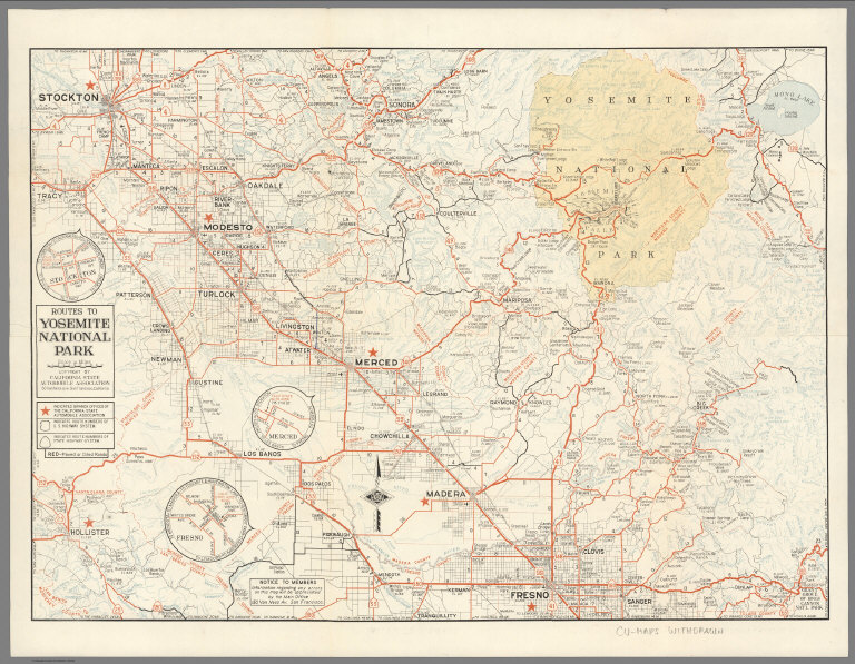
Author
CSAA (California State Automobile Association)
Full Title
Routes to Yosemite National Park. Copyright by the California State Automobile Association.
List No
6314.001
Note
Brochure. Printed front and back. Distinguishes oil and paved roads.
CSAA (California State Automobile Associ... Roads in Yosemite Valley. Routes to Yose... 1948 6314.002 Related Author
CSAA (California State Automobile Association)
Full Title
Roads in Yosemite Valley. Routes to Yosemite National Park. Map Issued by California State Automobile Association.
List No
6314.002
Note
Brochure. Printed front and back. Distinguishes oil and paved roads.
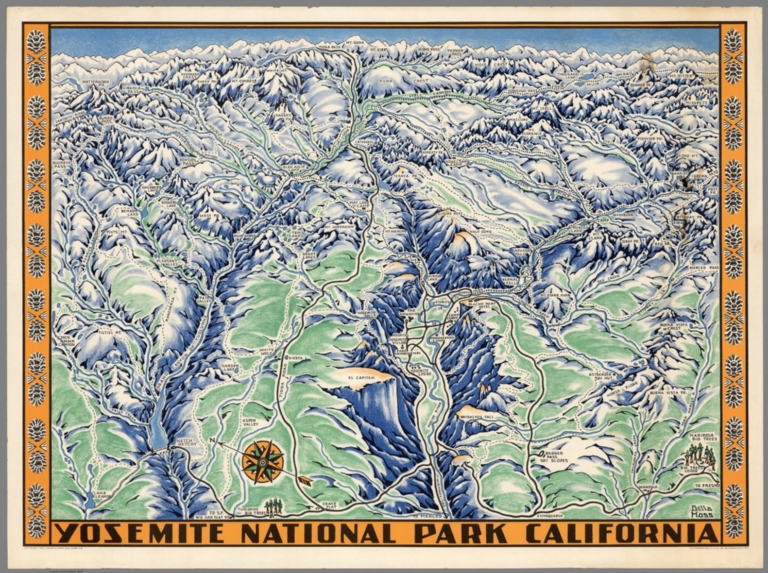
Author
Hoss, Della Taylor
Full Title
Yosemite National Park California. Della Hoss. Copyright 1955 Yosemite Park and Curry Co. Lithographed in U.S.A. by Schwabachcer-Frey Co.
List No
8278.000
Note
Shaded relief, bird's eye view by Della Hoss of the Yosemite Valley, with decorative border. Relief shown pictorially. Rivers, lakes, mountain peaks, passes, roads, trails, and location of major attractions and lodgings facilities, and camps rounds are named. Decorative compass rose oriented with the north to the left.
Author
Mora, Jo (1876-1947)
Full Title
Yosemite. Cpyright 1931. Jo Mora.
List No
8512.000
Note
Second color issue, after the first color in 1941. Remarkably cute vignettes on a birdseye view of Yosemite Valley and vicinity. For more information on Jo Mora's life and works, see http://www.jomoratrust.com
Author
Mora, Jo (1876-1947)
Full Title
Yosemite. Copyright 1931. Jo Mora.
List No
8558.000
Note
First color issue. With the automobile road in lower left not straightened out, and with the rider upper left facing right. Remarkably cute vignettes on a birdseye view of Yosemite Valley and vicinity. For more information on Jo Mora's life and works, see http://www.jomoratrust.com
Author
Barnes, C.
Full Title
The Valley of Yosemite National Park : q willy nilly map. Cartograph C. Barnes 1946. (On verso) High Sierra country surrounds Yosemite Valley.
List No
9987.001
Note
2 maps on one sheet, both sides. Bird's-eye view pictorial map of, 40x48 folded 18x24, double fold as issued, intended to be mailed. Map shows view of the valley with points of interests numbered and identified on verso, roads, trails, buildings, wildlife, people's activities, etc. On verso: includes black and white pictorial map of High Sierra country with view of the surrounding country, points of interest are numbered and indexed.
Author
Barnes, C.
Full Title
High Sierra country surrounds Yosemite Valley. (on verso) The Valley of Yosemite National Park : a willy nilly map. Cartograph C. Barnes 1946.
List No
9987.002
Note
2 maps on one sheet, both sides. Bird's-eye view pictorial map of, 40x48 folded 18x24, double fold as issued, intended to be mailed. Map shows view of the valley with points of interests numbered and identified on verso, roads, trails, buildings, wildlife, people's activities, etc. On verso: includes black and white pictorial map of High Sierra country with view of the surrounding country, points of interest are numbered and indexed.
1-42 of 42
|