|
Author
Brown, Constance
Full Title
Nantucket Island.
List No
15610.000
Author
Brown, Constance
Full Title
Costa Rica.
List No
15611.000
Author
Brown, Constance
Full Title
New Haven Apizza.
List No
15612.000
Author
U.S. Geological Survey
Full Title
Machine-Made Physiographic Map of the Conterminous United States.
List No
12244.001
Note
Date estimated.
Author
U.S. Geological Survey
Full Title
(Text Page) Machine-Made Physiographic Map of the Conterminous United States.
List No
12244.002
Note
Date estimated.
Author
Truskot, Ivan (1721-1786)
Full Title
Karta, predstavliaiushchaia Pol’shu i Moldaviiu s okolo lezhashchimi zemliami, sochinennaia pri Imper.[atorskoi] Akademii Nauk po noveishim izvestiiam Tituliarnym sovetnikom i Ad’iutantom Ivanom Truskotom [i.e. Map Displaying Poland and Moldavia with Surrounding Lands, Compiled Basing on the Latest Data by Titular Councilor, Adjunct Professor Ivan Truskot in the Imperial Academy of Sciences]
List No
15642.000
Author
SCHWEIZERISCHEN OBERPOSTDIREKTION
Full Title
Schweizerische Postverwaltung. Übersicht der internen Postverbindungen (mit den ausländischen Anschlüssen). Winterdienst 1902/03. / Administration des Postes suisses. Tableau des Communicators postales internes et des routes étragers correspondants. Service d’hiver 1902/03.
List No
15643.000
Author
K.K. ÖSTERREICHISCHE STAATSBAHNEN [IMPERIAL & ROYAL AUSTRIAN RAILWAYS]
Full Title
K.k. Österreichische Staatsbahnen. K.k. Nordwestbahndirektion. / Linien: Nordwestbahnhof – Tetschen Nordwestbahnhof - (Mittelgrund), Iglau Nordwestbahnhof – Iglau Stadtbahnhof, Schreckenstein – Aussig Templitzerbahnhof.
List No
15644.000
Author
鈴木茂行 [SUZUKI Shigeyuki] (fl. 1895 - 1903)
Full Title
新撰臺灣明細全圖 [New, Complete and Detailed Map of Taiwan].
List No
15645.001
Author
Anonymous
Full Title
Manuscript Map
List No
15645.002
Note
"On the verso is an unfinished manuscript map that depicts a locality, with all details unlabelled, with sub-jurisdictions outlined in the own bright hues, and a river running through it, while a legend, upper-right, defines unused symbols. We have not been able to identify the subject of the map, and even whether it pertains in any way to Taiwan. However, the note in the lower right, seems to refer to “Nagai Village”, which if true might refer to a town in the Yamagata Prefecture of north-central Japan. This is perhaps a matter for further research." (See Pub note)
Author
[Union Pacific Railway Company. Passenger Department, Rand McNally & Co.]
Full Title
Tourist Map of Union Pacific and Connecting Lines. (to accompany) Sights and Scenes in California for the Tourists. Complement of the Passenger Department, Union Pacific Ry. Omaha, Neb. Rand McNally & co., Printers, Chicago. Copyright, 1888, by J. S. Tebbets, General Passenger Agent, Union Pacific Ry, Omaha, Neb. (cover title) California. Sights and Scenes for the Tourist.
List No
11904.020
Note
Pictorial folded map inserted loose in the accompanying guide book. 33 pages with information on places of interest in the state for the tourists, including 2 pages of advertisements and black and white photos. Map shows Union Pacific and connecting routes from Omaha and Kansas City to the west coast Los Angeles in the south and Seattle in the north. Includes profile of the comparative heights of the mountains from San Francisco to Omaha and inset "Map of the loop". The route shown in red. Includes vignettes showing places of interest, mining, agricultural products and livestock. Relief shown pictorially and by hachures.
Author
Pan American World Airways.
Full Title
(Covers to) Flying Clipper-wise. Pan American World Airways.
List No
12222.001
Note
Front and back covers.
Author
Pan American World Airways.
Full Title
(Composite Text) Flying Clipper-wise. Pan American World Airways.
List No
12222.002
Author
[Pan American World Airways., Jeppesen and Company]
Full Title
(Text and Views) Pan American World Airways Destinations Unlimited.
List No
12222.003
Author
[Pan American World Airways., Jeppesen and Company]
Full Title
(Text and Views) Pan American World Airways Destinations Unlimited.
List No
12222.004
Author
[Pan American World Airways., Jeppesen and Company]
Full Title
(World Route Map, Pan Am Clippers, Pan American World Airways.)
List No
12222.005
Note
Full color with shaded relief.
Author
New York Central Railroad Company
Full Title
New York City : explanation New York Central system. (to accompany) New York Visitor. Vol. 13 No. 6 June 1946 A Magazine of Metropolitan events and handbook of New York City. Copyright 1949, and published monthly by the New York Central System. Louise Bascom Barratt, Editor.
List No
11914.011
Note
Visitor guide of New York City in 40 pages, with a folded map. Published monthly for the information of passengers by New York Central System. Title page includes table of contents. Contains advertisement, illustrations and text to places of interest, shopping, restaurants and a list of hotels. Map shows rail lines, ferries, and car floats routes in red, also showing subways, elevated train line, stations, tunnels, etc. Includes place names, some points of interest and landmarks. Includes compass rose oriented with north oriented to the upper left.
Author
Loots, Johannes (w. 1693-1726).
Full Title
De Baay en Stad van Gibralter. Tot Joannes Loots, boek zeekard verkooper en graadbook maker inde Nieuwe-brigsteeg inde Jonge Lootsman, Amsterdam, 1704
List No
15618.000
Note
Loots published a page of text explaining the map, see https://iiif.lib.harvard.edu/manifests/view/ids:54238628
Author
[Loots, Johannes (w. 1693-1726)., Veltman, Lourens]
Full Title
(Text page to) De Baay en Stad van Gibralter. Tot Joannes Loots, boek zeekard verkooper en graadbook maker inde Nieuwe-brigsteeg inde Jonge Lootsman, Amsterdam, 1704
List No
15618.001
Note
Original at Harvard Map Collection. Loots published a page of text explaining the map, see https://iiif.lib.harvard.edu/manifests/view/ids:54238628
Author
Musnitskii, M.
Full Title
Karta tamozhennykh uchrezhdenii s graficheskim pokazaniem privoza i vyvoza tovarov, soglasno obzoru vneshnei torgovli za 1873 god [i.e. Map of Custom Offices with Import and Export of Goods Indicated Graphically, According to the 1873 Survey of Foreign Trade] / Compiled by editor of the Central Statistical Committee, M. Musnitskii. St. Petersburg: Litografiia G. Gofman, 1874
List No
15621.000
Author
Sikora, Wincenty (1878-1958)
Full Title
Rozsiedlenie ludności Polskiej w Księstwie Cieszyńskim. La reportition de la population Polonaise dans la principaute de Cieszyn. The Polish population in the province of Teschen
List No
15560.000
Author
U.S. General Land Office
Full Title
Map Of The United States And Territories. To accompany annual report of Hon. Wm. A.J. Sparks Commissioner, General Land Office for fiscal year which ended June 30, 1885 ... N. Peters Photo-Lithographer, Washington, D.C. (inset) Alaska Territory.
List No
2353.002
Author
Maury, Matthew Fontaine, 1806-1873
Full Title
Whale Chart by M.F. Maury A.M. Liet. U.S. Navy. (Preliminary sketch) Series F. Constructed by Lts. Leigh Herndon & Fleming & Pd. Midn. Jackson. Published at the National Observatory by Authority of Commo. L. Warrington Chief of bureau of Ordnance & Hydrography 1851.
List No
15606.000
Note
Later reissue in circa 1960.
Author
Brue, A.H.
Full Title
Nouvelle Carte du Mexique, Et D'Une Partie Des Provinces Unies De L'Amerique Centrale. Dediee a l'Academie Royale des Sciences de l Institut de France. Par A.H. Brue, Geographe du Roi, Membre de la common. centrale de la societe de Geographie de Paris, membre-honoraire de celle de Londres, &a. Paris. 1834. Chez Ch. Picquet, Geographe du Roi et du Due d'Orleans, Proprietaire des Cartes et Atlas de Brue, Quai Conti No. 17, pres de l'Institut ... Revue et augmentee par Ch. Picquet, en 1837 ... (with 2 inset maps).
List No
3138.000
Author
Brue, Adrien Hubert, 1786-1832
Full Title
Nouvelle Carte du Mexique, Du Texas Et D'Une Partie Des Provinces Unies De L'Amerique Centrale. Dediee a l'Academie Royale des Sciences de l Institut de France. Par A.H. Brue, Geographe du Roi, Membre de la common. centrale de la societe de Geographie de Paris, membre-honoraire de celle de Londres, &a. Revue et augmentee par Ch. Picquet, Geographe du Roi et du Due d'Orleans, Proprietaire des Cartes et Atlas de Brue, Quai Conti No. 17, pres de l'Institut. Paris, 1840. Publiee en 1834; Revue en 1837, 1839, 1840 ... (with 2 inset maps).
List No
5396.000
Note
This 1840 issue of the original 1834 Brue Mexique adds Texas to the title for the first time, as well as many new towns and proposed railroads in Texas. The Great Basin is redrawn based on the John Arrowsmith map of British North America, 1837. Map in outline color. Inset maps include: 1) Details des environs de Mexico et de la Vera-Cruz, 2) Complement de la Carte donnant Le Yucatan et une partie des provinces unies de l'Amerique Centrale.
Author
[Brue, Adrien Hubert, 1786-1832, Vuillemin, A.]
Full Title
Nouvelle Carte du Mexique, Du Texas Et D'Une Partie Des Etats Limitrophes; Dediee a l'Academie Imp..le des Sciences de l Institut de France. Par A.H. Brue, Geographe, Membre de la common. centrale de la societe de Geographie de Paris, membre-honoraire de celle de Londres, &a. Revue et augmentee par A. Vuillemin. Paris. A. Logerot, editeur, Quai des Augustins 55. 1862 (with 2 inset maps).
List No
15597.001
Note
This is the digitally restored copy.
Author
[Brue, Adrien Hubert, 1786-1832, Vuillemin, A.]
Full Title
Nouvelle Carte du Mexique, Du Texas Et D'Une Partie Des Etats Limitrophes; Dediee a l'Academie Imp..le des Sciences de l Institut de France. Par A.H. Brue, Geographe, Membre de la common. centrale de la societe de Geographie de Paris, membre-honoraire de celle de Londres, &a. Revue et augmentee par A. Vuillemin. Paris. A. Logerot, editeur, Quai des Augustins 55. 1862 (with 2 inset maps).
List No
15597.003
Note
This is the 1863 issue which was used to restore the missing bottom two inset maps.
Author
[Geographisches Institut (Weimar), Streit, Friedrich Wilhelm, 1772-1839]
Full Title
Sect. 58. Theil vom Konigrch. Westphalen = Partie du Royme. de Westphalie. Weimar, im Verlage des Geographischen Institut. (to accompany) Topographisch-militairische Charte von Teutschland : in 204 Sectionen ... 1807. = Carte topographique et militaire de L'Allemagne ... 1807-1813.
List No
15616.002
Note
Engraved map of Magdeburg, Westphalia. Relief shown by hachures and form lines.
Author
[Geographisches Institut (Weimar), Streit, Friedrich Wilhelm, 1772-1839]
Full Title
(Sect. 83). Theil von Sachsen. = Partie de la Saxe
List No
15616.003
Note
Engraved map of Altenburg and environs, Saxony. Relief shown by hachures and form lines.
Author
[Geographisches Institut (Weimar), Streit, Friedrich Wilhelm, 1772-1839]
Full Title
Sect. 69. Theil von Thuringen. = Partie de la Thuringue
List No
15616.004
Note
Engraved map of Eisleben, Thuringen. Relief shown by hachures and from lines.
Author
[Geographisches Institut (Weimar), Streit, Friedrich Wilhelm, 1772-1839]
Full Title
Sect. 59. Theil von Ober-Sachsen = Partie de la Haute-Saxe
List No
15616.005
Note
Engraved map of Dessau, Upper Saxony. Relief shown by hachures and form lines.
Author
[Geographisches Institut (Weimar), Streit, Friedrich Wilhelm, 1772-1839]
Full Title
Sect. 82. Theil von Sachsen. = Partie de la Saxe.
List No
15616.006
Note
Engraved map of Erfurt, Saxony. Relief shown by hachures and form lines.
Author
[Geographisches Institut (Weimar), Streit, Friedrich Wilhelm, 1772-1839]
Full Title
Sect. 70. Theil von Sachsen. = Partie de la Saxe
List No
15616.007
Note
Engraved map of Leipzig, Saxony. Relief shown by hachures and from lines.
Author
[Geographisches Institut (Weimar), Streit, Friedrich Wilhelm, 1772-1839]
Full Title
Sect. 71. Theil von Sachsen. = Partie de la Saxe (with) Sect. 72. Theil der Lausitz. = Partie de la Lusace
List No
15616.008
Note
Engraved map of Torgau, Saxony. Relief shown by hachures and from lines (with) Engraved map of Spremberg, Saxony. Relief shown by hachures.
Author
[Geographisches Institut (Weimar), Streit, Friedrich Wilhelm, 1772-1839]
Full Title
Sect. 50. Theil von der Mittel-Mark = Partie de la Moyenne Marche (with) Sect. 51. Theil von der Mittel-Mark = Partie de la Moyenne Marche (with) Sect. 60 . Theil der Lachen. = Partie de la Paxe. (with) Sect. 61. Theil der Lausiz. = Partie de la Lusace
List No
15616.009
Note
Engraved map of Berlin and environs, Mittelmark. Relief shown by hachures. (with) Engraved map of Frankfurt and environs, Mittelmark. Relief shown by hachures.(with) Engraved map of Guben, Brandenburg. Relief shown by hachures. (with) Engraved map of Guben, Brandenburg. Relief shown by hachures.
Author
British Information Services
Full Title
Great Britain Her Natural & Industrial Resources
List No
15593.000
Note
Date is estimated.
Author
Ordnance Survey Office
Full Title
Training Target No. S. 2047 / Perspective (Jan 1943) King's Lynn (England)
List No
15605.000
Author
[Brue, Adrien Hubert, 1786-1832, Vuillemin, A.]
Full Title
Nouvelle Carte du Mexique, Du Texas Et D'Une Partie Des Etats Limitrophes; Dediee a l'Academie Imp..le des Sciences de l Institut de France. Par A.H. Brue, Geographe, Membre de la common. centrale de la societe de Geographie de Paris, membre-honoraire de celle de Londres, &a. Revue et augmentee par A. Vuillemin. Paris. A. Logerot, editeur, Quai des Augustins 55. 1862 (with 2 inset maps).
List No
15597.002
Note
This is the original unrestored copy with the bottom two inset maps deleted.
Author
Boazio, Baptista
Full Title
The Famouse West Indian voyadge made by the Englishe fleete of 23 shippes and Barkes wherin weare gotten the Townes of St. Iago: Sto. Domingo, Cartagena and St. Augustines ... Newlie come forth by Baptista B.
List No
15582.002
Note
Copy of map belonging to the John Carter Brown Library, item 28546.
Author
Gutierrez, Pedro (fl. 1900 - 1957)
Full Title
Plano de Subdivision Country Club Park. Propiedad Del County Club Park Investment Company. Habana Cuba 1924
List No
15581.000
Author
Dripps, M.
Full Title
Map of New York City South of 132d St.
List No
12308.002
Note
Black and white. Date estimated.
Author
Turner, Stanley
Full Title
Dated Events War Map. 1945. 17th Edition.
List No
15498.000
Author
Keihin Electric Express
Full Title
緑のなぎさ! 三浦半島&南房総 品川案内所·東京(441)0573~ 日の出町案内所 横浜(23)5523 京浜急行 (Green beach! Miura Peninsula & Minamiboso Shinagawa Information Center Tokyo (441) 0573~4 Hinode Town Information Center Yokohama (23) 5523 Keihin Electric Express)
List No
15497.000
Author
Eckersley, Tom
Full Title
Aer Lingus Lignes Aeriennes Irlandaises.
List No
15545.000
Author
[Lee, Eric, Crowe, George]
Full Title
Alaska Flight Planning Map
List No
15556.001
Author
[Lee, Eric, Crowe, George]
Full Title
(Text page to) Alaska Flight Planning Map
List No
15556.002
Note
Includes airport diagrams.
Author
Anonymous
Full Title
Meridian Highway. U.S. 81 Throughout. The Main Street of North America.
List No
15557.000
Author
[United States Information Agency, General Drafting Co. Inc.]
Full Title
Ένας εικονογραφικός χάρτης των Ηνωμένων Πολιτειών της Αμερικής: Εμφάνιση κύριων περιφερειακών πόρων, προϊόντων και φυσικών χαρακτηριστικών. (A Pictorial map of the United States of America : Showing principal regional resources, products and natural features.)
List No
15554.000
Author
[United States Information Agency, General Drafting Co. Inc.]
Full Title
Pictorial map of the United States of America : Showing principal regional resources, products and natural features.
List No
15555.000
Author
Board of State Harbor Commissioners
Full Title
Map of the Waterfront of San Francisco 1940.
List No
15550.000
Author
Gelling, Stan
Full Title
Hysterical Map of Lake Pend O'Reille Where The Navy Goes To See.
List No
15552.000
Author
[Smith, O.A., Pacific Electric Railway]
Full Title
Relief Map of Territory Served by Lines of Pacific Electric Railway in Southern California. Largest Electric Railway System in the World.
List No
15553.000
Author
Jenkins, Olaf P.
Full Title
Sheet No. I Northern Section. Geologic Map of California Prepared by Olaf P. Jenkins Chief Geologist, Geologic Branch
List No
15485.001
Note
Dimensions are sheet size.
Author
Jenkins, Olaf P.
Full Title
Sheet No. II Central Section. Geologic Map of California Prepared by Olaf P. Jenkins Chief Geologist, Geologic Branch
List No
15485.002
Note
Dimensions are sheet size.
Author
Jenkins, Olaf P.
Full Title
Sheet No. III Southwest Coast Section. Geologic Map of California Prepared by Olaf P. Jenkins Chief Geologist, Geologic Branch.
List No
15485.003
Note
Dimensions are sheet size.
Author
Jenkins, Olaf P.
Full Title
Sheet No. IV Geologic Legend. Geologic Map of California Prepared by Olaf P. Jenkins Chief Geologist, Geologic Branch.
List No
15485.004
Note
Dimensions are sheet size.
Author
Jenkins, Olaf P.
Full Title
Sheet No. V East-Central Section. Geologic Map of California Prepared by Olaf P. Jenkins Chief Geologist, Geologic Branch.
List No
15485.005
Note
Dimensions are sheet size.
Author
Jenkins, Olaf P.
Full Title
Sheet No. VI Southern Section. Geologic Map of California Prepared by Olaf P. Jenkins Chief Geologist, Geologic Branch.
List No
15485.006
Note
Dimensions are sheet size.
Author
Jenkins, Olaf P.
Full Title
(Composite map of) Sections I-VI. Geologic Map of California Prepared by Olaf P. Jenkins Chief Geologist, Geologic Branch
List No
15485.007
Note
Dimensions are sheet size.
Author
Maury, Matthew Fontaine, 1806-1873
Full Title
Monsoon and Trade Wind Chart of the Indian Ocean.
List No
15547.000
Author
Generalny Shtab Kranoi Armii
Full Title
(Map of Kharkiv/Kharkov)
List No
15543.000
Author
Izdaniye rabochei gazety Proletar
Full Title
Плян мiста Харкова. Видання робітничої газети «Пролетар». Маштаб 1: 40 000. 1930 р. Тираж 6100. Харьков: Картвiддiл У. Г. У. Харкiв, 1930.
List No
15544.000
Author
BINBASI HALIL IBRAHIM EFENDI, (Mekâtîb-i Fünûn-i Harbiye-i Sahâne'de topografya muallimi muavini)
Full Title
Üçyüz onüç senesi Serez'de zuhûr olan Yunan Muharebesi'nde Yanya Redif Taburu Binbasi vekâletini ifâ eylemek üzere Yanya Kolordu-yi Hûmâyûnu'na i'zâm edilmis olan Mekâtîb-i Fünûn-i Harbiye-i Sahâne'de topografya muallimi muavini Binbasi Halil Ibrahim Efendi tarafindan 1/50000 nisbette olarak istiksâf usûliyle yeniden ahz ve tersîm edilen ve Yanya Vilâyeti'nin kism-i cenûbîsini mufassalen irae eyleyen isbu harita Mekâtib-i Fünûn-i Harbiyye-i Sahâne sinif-i muhtelîfesi sâkirdânina tedrîs edilmekte olan Fünûn-i Askeriye tatbîkâtinca isti'mâl edilmek üzere Meclis-i Maârif-i Askeriye tarafindan kabûl buyurularak mekteb-i mezkûr matbaasinda tab' olunmustur. Def'a-yi Saniyye, Sene-yi Maliyye 1318.
List No
15546.000
Author
[Williams, Rhys (1894-1976), Qantas Empire Airways, ltd.]
Full Title
Out of a Great Past a Greater Future. Qantas Empire Airways. The Big Name In Empire Aviation.
List No
15531.000
Note
Date estimated.
Author
Teleshov, L.
Full Title
(Covers to) Skhematicheskaia gornozavodskaia karta zapadnoi i vostochnoi chastei Donetskogo basseina. 1901-1902 [i.e. Schematic Mining Map of Western and Eastern Parts of Donets Basin]
List No
15526.001
Author
Teleshov, L.
Full Title
Skhematicheskaia gornozavodskaia karta zapadnoi i vostochnoi chastei Donetskogo basseina. 1901-1902 [i.e. Schematic Mining Map of Western and Eastern Parts of Donets Basin]
List No
15526.002
Author
Field, Henry M.
Full Title
(Covers to) Map of the Presbyterian Church In The United States. Reduced From the Large Map Published by the New York Evangelist.
List No
3248.001
Author
Field, Henry M.
Full Title
Map of the Presbyterian Church In The United States. Reduced From the Large Map Published by the New York Evangelist.
List No
3248.002
Author
Fuller, R. Buckminster
Full Title
Dymaxion Sky - Ocean World. Grip-Kitrick Edition of Fuller Projection. U.S. Patent 2,393,676.
List No
15488.000
Author
Anonymous
Full Title
(Covers to) San Francisco 1915 Hotel Dale Souvenir.
List No
15475.001
Author
Anonymous
Full Title
San Francisco 1915 Hotel Dale Souvenir.
List No
15475.002
Author
Anonymous
Full Title
(Text page to) San Francisco 1915 Hotel Dale Souvenir.
List No
15475.003
Author
U.S. Government Printing Office
Full Title
MAP OF THE CITY OF WASHINGTON STREET CLEANING DEPARTMENT
List No
15462.000
Author
Chinese Society for Foreign Tourism (Intourist)
Full Title
(Covers to) Наша Прекрасная Родина. Пекин: Китайское общество по иностранному туризму (Интурист) (Our Beautiful Motherland)
List No
15432.001
Author
Chinese Society for Foreign Tourism (Intourist)
Full Title
Наша Прекрасная Родина. Пекин: Китайское общество по иностранному туризму (Интурист) (Our Beautiful Motherland)
List No
15432.002
Author
Trabacchi, Augusto
Full Title
(Covers to) PIANTA PANORAMICA DI ROMA [PANORAMA OF ROME]
List No
15434.003
Note
Date estimated.
Author
Trabacchi, Augusto
Full Title
PIANTA PANORAMICA DI ROMA [PANORAMA OF ROME]
List No
15434.001
Note
Date estimated.
Author
Trabacchi, Augusto
Full Title
(Text page to) PIANTA PANORAMICA DI ROMA [PANORAMA OF ROME]
List No
15434.002
Note
Date estimated.
Author
Kinnear, Josiah
Full Title
INDEXED COMMERCIAL MAP OF COLUMBUS, OHIO
List No
15435.000
Author
San Mateo Chamber of Commerce
Full Title
San Mateo
List No
15467.001
Author
San Mateo Chamber of Commerce
Full Title
(Text page to) San Mateo
List No
15467.002
Author
[Horowitz, Michael, Reemes, Diana, Harrison, Kathleen]
Full Title
Map of Historic Sites of LSD Discovery, Research, & Culture
List No
15468.001
Author
[Horowitz, Michael, Reemes, Diana, Harrison, Kathleen]
Full Title
(Text page to) Map of Historic Sites of LSD Discovery, Research, & Culture
List No
15468.002
Note
Verso of the LSD map, indicates page 10 in lower left corner, likely from a magazine or journal.
Author
Departamento de Turismo da Municipalidade do Rio de Janeiro
Full Title
(Covers to) Ilhas Do Rio De Janeiro
List No
15469.001
Note
Date estimated.
Author
Departamento de Turismo da Municipalidade do Rio de Janeiro
Full Title
Ilhas Do Rio De Janeiro
List No
15469.002
Note
Date estimated.
Author
Departamento de Turismo da Municipalidade do Rio de Janeiro
Full Title
(Text page to) Ilhas Do Rio De Janeiro
List No
15469.003
Note
Date estimated.
Author
Dreikorn, Lud
Full Title
Plan De La Ciudad De San Salvador
List No
15470.001
Author
Dreikorn, Lud
Full Title
Plan De La Ciudad De San Salvador
List No
15470.002
Note
Advertisements with inset map of El Salvador.
Author
Bererd, Francis
Full Title
Casablanca
List No
15471.000
Note
Date estimated.
Author
[Department of Tourism, Chile, Dupre, Emilio]
Full Title
(Covers to) Provincia de Santiago Chile
List No
15473.001
Note
Date estimated.
Author
[Department of Tourism, Chile, Dupre, Emilio]
Full Title
Provincia de Santiago Chile
List No
15473.002
Note
Date estimated.
Author
[Department of Tourism, Chile, Dupre, Emilio]
Full Title
(Text page to) Provincia de Santiago Chile
List No
15473.003
Note
Date estimated.
Author
[Department of Tourism, Chile, Dupre, Emilio]
Full Title
(Covers to) Provincia de Santiago Chile
List No
15473.004
Note
Date estimated. The map includes a portion of the original mailing envelope, indicating it was sent via Diplomatic Mail from the Chilean Embassy in Washington, D.C. to a recipient in Danville, California.
Author
Jontzen, Wilhelm
Full Title
(Covers to) Guide Through Munchen.
List No
15476.001
Author
Jontzen, Wilhelm
Full Title
Guide Through Munchen.
List No
15476.002
Author
Jontzen, Wilhelm
Full Title
(Text page to) Guide Through Munchen.
List No
15476.003
Author
Western Union
Full Title
Western Union Trans-Atlantic Cables and Connections. The Fast Route to America.
List No
15456.000
Note
Date estimated.
Author
Chase, Ernest Dudley, 1878-1966
Full Title
America the Wonderland : A Pictorial Map of the United States. Designed and drawn by Ernest Dudley Chase of Winchester, Massachusetts. Published and copyrighted by Ernest Dudley Chase of Winchester, Mass. Reprinted by permission of the copyright owner, Ernest Dudley Chase.
List No
15457.001
Note
Printed in the Philadelphia Inquirer April 25, 1954. This is the color version, see also our black and white version. Pictorial map of the United States of America, filled with an abundance of vignettes, illustrating buildings and landmarks, natural resources, scenic highlights and other attractions with explanation notes. Included are the Empire State Building, the Capitol building, the Rose Bowl, various missions and churches, oil wells, factories, buffalo, horses, state capital buildings, and the Alamo. Around the map are several larger inset views with brief descriptions, for example, the Mormon Temple of Salt Lake City, the Lincoln Memorial, Rockerfeller Chapel, Independence Hall, and Yale University. Geographical features include states, major cities, universities, national parks, rivers and lakes. The map is decorated with a red, yellow and black compass rose in the upper right corner; a cartouche flanked by two bald eagles perched on banners; and an Art Deco border with acorn and leaf corners.
Author
Chase, Ernest Dudley, 1878-1966
Full Title
(Text page to) Album of Natural Hisotry. Colorama.Section of The Philadelphia Inquirer Sunday, April 25, 1954..
List No
15457.002
Note
Verso of the map page.
Author
Lindgren, Jolly (1895-1952)
Full Title
(Covers to) A Hysterical Map of the Territory Served by H. Earl Clack Company Service Stations / A Hysterical Road Map (Somewhat Cockeyed) Showing Most of the Points You Will Be Able To Obtain Hi-Power Service in Montana & North Dakota. Look For The Clack Orange Pumps.
List No
15458.001
Author
Lindgren, Jolly (1895-1952)
Full Title
A Hysterical Map of the Territory Served by H. Earl Clack Company Service Stations / A Hysterical Road Map (Somewhat Cockeyed) Showing Most of the Points You Will Be Able To Obtain Hi-Power Service in Montana & North Dakota. Look For The Clack Orange Pumps.
List No
15458.002
Author
Lindgren, Jolly (1895-1952)
Full Title
A Hysterical Map of the Territory Served by H. Earl Clack Company Service Stations / A Hysterical Road Map (Somewhat Cockeyed) Showing Most of the Points You Will Be Able To Obtain Hi-Power Service in Montana & North Dakota. Look For The Clack Orange Pumps.
List No
15458.003
Author
Lindgren, Jolly (1895-1952)
Full Title
(Covers to) A Hysterical Map of the Territory Served by H. Earl Clack Company Service Stations / A Hysterical Road Map (Somewhat Cockeyed) Showing Most of the Points You Will Be Able To Obtain Hi-Power Service in Montana & North Dakota. Look For The Clack Orange Pumps.
List No
15458.004
Author
Washburn, Bradford
Full Title
(Covers to) MOUNT WASHINGTON and the heart of THE PRESIDENTIAL RANGE, New Hampshire.
List No
15453.001
Author
Washburn, Bradford
Full Title
MOUNT WASHINGTON and the heart of THE PRESIDENTIAL RANGE, New Hampshire.
List No
15453.002
Author
[Fuller, R. Buckminster, Sadao, Shoji]
Full Title
The Fuller Dymaxion Air-Ocean World
List No
15454.001
Author
[Fuller, R. Buckminster, Sadao, Shoji]
Full Title
(Text page to) The Dymaxion Airocean World Fuller Projective-Transformation. Fluid Geography.
List No
15454.002
Author
[Fuller, R. Buckminster, Sadao, Shoji]
Full Title
Dymaxion Air Ocean World
List No
15455.000
Note
Facsimile Of the 1954 Raleigh Edition of the Dymaxion Airocean World Map.
Author
Fuller, R. Buckminster
Full Title
(Covers to) Fluid Geography.
List No
15452.001
Author
Fuller, R. Buckminster
Full Title
World Map on Dymaxion Projection. Fist edition published by Atlantic Neptune.
List No
15452.002
Author
Fuller, R. Buckminster
Full Title
(Composite text to) Fluid Geography.
List No
15452.003
Author
[Estéban PICHARDO y Tapia (1799 - 1879), VALDEPARES, Jose]
Full Title
Plano de la Habana por D. Estéban T. Pichardo, agrimensor y maestro de obras. / Editor: D. Jose Valdepares. / 1881.
List No
15447.000
Author
EAST AFRICA SURVEY GROUP (BRITISH ARMY) - 157TH (EAST AFRICA & SOUTHERN RHODESIA)
Full Title
[Nairobi:] No. 1 (East Africa Reproduction) Section [Survey Directorate, East Africa Command], April 1946 G.P. No. 2725
List No
15446.001
Author
[EAST AFRICA SURVEY GROUP (BRITISH ARMY) - 157TH (EAST AFRICA & SOUTHERN RHODESIA), BASE SURVEY COMPANY]
Full Title
[Nairobi:] No. 2 (East Africa Reproduction) Section [Survey Directorate, East Africa Command], April 1946 G.P. No. 2725
List No
15446.002
Author
[EAST AFRICA SURVEY GROUP (BRITISH ARMY) - 157TH (EAST AFRICA & SOUTHERN RHODESIA), BASE SURVEY COMPANY]
Full Title
[Nairobi:] No.3 (East Africa Reproduction) Section [Survey Directorate, East Africa Command], April 1946 G.P. No. 2725
List No
15446.003
Author
[EAST AFRICA SURVEY GROUP (BRITISH ARMY) - 157TH (EAST AFRICA & SOUTHERN RHODESIA), BASE SURVEY COMPANY]
Full Title
[Nairobi:] No. 4 (East Africa Reproduction) Section [Survey Directorate, East Africa Command], April 1946 G.P. No. 2725
List No
15446.004
Author
[EAST AFRICA SURVEY GROUP (BRITISH ARMY) - 157TH (EAST AFRICA & SOUTHERN RHODESIA), BASE SURVEY COMPANY]
Full Title
[Nairobi:] No. 5 (East Africa Reproduction) Section [Survey Directorate, East Africa Command], April 1946 G.P. No. 2725
List No
15446.005
Author
[EAST AFRICA SURVEY GROUP (BRITISH ARMY) - 157TH (EAST AFRICA & SOUTHERN RHODESIA), BASE SURVEY COMPANY]
Full Title
[Nairobi:] No. 6 (East Africa Reproduction) Section [Survey Directorate, East Africa Command], April 1946 G.P. No. 2725
List No
15446.006
Author
[EAST AFRICA SURVEY GROUP (BRITISH ARMY) - 157TH (EAST AFRICA & SOUTHERN RHODESIA), BASE SURVEY COMPANY]
Full Title
(Composite map to) [Nairobi:] No.1-6 (East Africa Reproduction) Section [Survey Directorate, East Africa Command], April 1946 G.P. No. 2725
List No
15446.007
Author
[Horton, Leonard Roy, Sandiford, Ronald]
Full Title
Pan American . La Compagnie. Aerienne La Plus. Experimentee. Du Monde. Horton - Sandiford
List No
15445.000
Author
Dorn, Frank (1901-1981)
Full Title
Being a Map of a Part of the Military Reservation of Camp Stotsenburg · Province of Pampanga · Philippine Islands
List No
15444.000
Author
[Visalia Stock Saddle Co., Jo Mora]
Full Title
(Text Page) Jo Mora's Map and Poster (Evolution of the Cowboy)
List No
9511.004
Author
[Greyhound Lines, Groth, John]
Full Title
(Covers to) 36,000 Miles of Vacation Highways - Reaching Every Nook and Corner of America - by Luxurious Greyhound Bus Lines.
List No
15440.001
Author
[Greyhound Lines, Groth, John]
Full Title
36,000 Miles of Vacation Highways - Reaching Every Nook and Corner of America - by Luxurious Greyhound Bus Lines.
List No
15440.002
Author
[Greyhound Lines, Groth, John]
Full Title
(Text page to) 36,000 Miles of Vacation Highways - Reaching Every Nook and Corner of America - by Luxurious Greyhound Bus Lines.
List No
15440.003
Author
FERROCARRIL CENTRAL MEXICANO COMPAÑIA LIMITADA
Full Title
Mapa del Ferrocarril Central Mexicano desde Paso del Norte pasando por los estados de Chihuahua, Durango, Coahuila, Zacatecas, Aguascalientes, Jalisco, Guanajuato y Queretaro hasta Mexico
List No
15439.000
Note
Date estimated.
Author
اركان حربيه عموميه دائره سنك بشنجى فن شعبه سنده FIFTH DRAFTING DEPARTMENT OF THE GENERAL MILITARY OFFICE].
Full Title
يمن ولايتى خريطة سى [Yemen Vilâyeti haritasi / Map of Yemen Vilayet].
List No
15428.000
Author
[USGS (U.S. Geological Survey), Renshawe, J. H. (John Henry), 1852-]
Full Title
Panoramic View of the Yellowstone National Park, Wyoming-Montana-Idaho.
List No
15423.000
Note
Date estimated. Shaded relief without contours. Full color artistic rendering of the park. Part of a series for the national parks.
Author
USSR (Union of Soviet Socialist Republics).
Full Title
Киев. Лист М-36-50. Шифр заказа Г-19 VI-86-К. Состояние местности на 1985 год. Издание 1986-го года. 1: 100 000 Под грифом «секретно». Цветная карта Генерального Штаба. (Kyiv. Sheet M-36-50. Order code G-19 VI-86-K. The state of the area in 1985. 1986 edition. 1: 100,000 Under the heading "secret". Color map of the General Staff)
List No
15424.000
Author
Song Chong Yue
Full Title
圖地新京北用兩 (Dual Purpose New Map of Beijing)
List No
15425.001
Note
Date estimated.
Author
Xiangdao Publishing Company
Full Title
(Covers to) 港九分區街道圖 Street Guide of District (Hong Kong and Kowloon)
List No
15427.001
Note
Date estimated
Author
Xiangdao Publishing Company
Full Title
(Sheet 1) 港九分區街道圖 Street Guide of District (Hong Kong and Kowloon)
List No
15427.002
Note
Date estimated
Author
Xiangdao Publishing Company
Full Title
(Sheet 2) 港九分區街道圖 Street Guide of District (Hong Kong and Kowloon)
List No
15427.003
Note
Date estimated
Author
Palmer, William. J.
Full Title
Map Of The Route Of The Southern Continental R.R. With Connections From Kansas City Mo. Ft. Smith Ark. And Shreveport La. Giving a general View of the Recent Surveys of the Kansas Pacific Railway Co, across the Continent Made in 1867 & 1868 under the direction of Gen. Wm. J. Palmer. On the routes of the 32nd and 35th Parallels. J.F Gedney Lith, Washington, D.C.
List No
3725.000
Note
Removed from Palmer's 1869 "Report of Surveys...for a route extending the Kansas Pacific Railway to the Pacific Ocean." Palmer used an exact copy Keeler's 1868 reduced scale edition of his National Map of the United States without credit in this first issue although Palmer's map adds much material along the line of the proposed southern continental route, especially in the Grand Canyon; in fact, this map is best known as the first map to use the name "Grand Canyon" of the Colorado. The Kansas Pacific had dreams of extending their line to California, as shown on this map, but it never happened. The map shows the routes of the Northern Pacific, the Union and Central Pacific, and the Southern Route. Ms color red and blue lines have been drawn on the various routes, adding an additional route from Centreville, Nevada, to Portland, Oregon (probably following Dodge's proposals - see his report). The main Kansas Pacific line has at least sixteen proposed branches! There is a later issue of this map that credits Keeler as a source (see our copy).
Author
Palmer, William. J.
Full Title
Map Of The Route Of The Southern Continental R.R. With Connections From Kansas City Mo. Ft. Smith Ark. And Shreveport La. Giving a general View of the Recent Surveys of the Kansas Pacific Railway Co, across the Continent Made in 1867 & 1968 under the direction of Gen. Wm. J. Palmer. On the routes of the 32nd and 35th Parallels together with compilations from Keeler's Official Map showing the Central and Northern Routes to the Pacific, and the intermediate topography. J.F Gedney Lith, Washington, D.C.
List No
4692.000
Note
This is a somewhat later issue of the Palmer map that adds a Keeler credit in the title, above the title adds the date June 1869 next to three railroad symbol explanations, and adds a table of "Distances by the Kansas Pacific Railway to Denver & Cheyenne thence by the Pacific Railroad to San Francisco," and eliminates the "explanations" in the lower right.
Author
[Gyger, Hans Konrad, 1599-1674, Imhof, Eduard, 1895-1986]
Full Title
(Covrs to) Karte des Kantons Zürich, vollendet 1667
List No
15416.001
Note
Facsimile in six sheets. A separate article about the map was written by Eduard Imhof for the Atlantis Monthly journal. The covers have the signature of Eduard Imhof so it is likely that this was his copy.
Author
[Gyger, Hans Konrad, 1599-1674, Imhof, Eduard, 1895-1986]
Full Title
Karte des Kantons Zürich, vollendet 1667
List No
15416.002
Note
Facsimile in six sheets. A separate article about the map was written by Eduard Imhof for the Atlantis Monthly journal. The covers have the signature of Eduard Imhof so it is likely that this was his copy.
Author
Canadian Pacific Railway Company
Full Title
Profile of Canadian Pacific Railroad Main Line Montreal to Vancouver.
List No
15415.000
Note
Verticle scale is 1:12,000 Date estimated.
Author
Donn, Benjamin
Full Title
This map of the country 11 miles round the City of Bristol Delineated from an actual survey; is inscribed ... by their hble. servant B. Donn. Printed for & sold by the author, B. Donn, ... Bristol. Published according to Act of Parliament November 6th 1769. Sold also. Printed for & sold by the author, B. Donn, ... Bristol. Published according to Act of Parliament November 6th 1769.... Sold also by R.Sayer..and T. Jefferys ... London. 1769 .
List No
15411.000
Author
Donn, Benjamin
Full Title
The Ge-Organon or World Delineated; a Substitute for the Terrestrial Globe. Part. 1st Invented by B. Donne
List No
15401.001
Note
Bristol, published by the author as the act directs, March 25th 1788.
Author
Donn, Benjamin
Full Title
The Ge-Organon or World Delineated; a Substitute for the Terrestrial Globe. Part. IId Invented by B. Donne
List No
15401.002
Note
Bristol, published by the author as the act directs, March 25th 1788.
Author
Abbas SAHAB (1921-2000)
Full Title
(Covers to) نقشه عمومي ايران سياسي، طبيعي، مردم شناسي [General Political, Physical and Anthropological Map of Iran]
List No
15406.001
Note
Date estimated.
Author
Abbas SAHAB (1921-2000)
Full Title
نقشه عمومي ايران سياسي، طبيعي، مردم شناسي [General Political, Physical and Anthropological Map of Iran]
List No
15406.002
Note
Date estimated.
Author
Abbas SAHAB (1921-2000)
Full Title
(Covers to) اروپا [Europe]
List No
15407.001
Note
Date estimated.
Author
Abbas SAHAB (1921-2000)
Full Title
اروپا [Europe]
List No
15407.002
Note
Date estimated.
Author
Abbas SAHAB (1921-2000)
Full Title
(Covers to) نقشه طبيعي سكسي جزاير اقيانوس كبير [Physical-Political Map of the Islands of the Great Ocean]
List No
15408.001
Note
Date estimated.
Author
Abbas SAHAB (1921-2000)
Full Title
نقشه طبيعي سكسي جزاير اقيانوس كبير [Physical-Political Map of the Islands of the Great Ocean]
List No
15408.002
Note
Date estimated.
Author
Abbas SAHAB (1921-2000)
Full Title
نقشه تقسيمات كشوري جمهورى اسلامى ايران [Map of Country Divisions of the Islamic Republic of Iran]
List No
15409.000
Note
Date estimated.
Author
Matz, Otto H.
Full Title
(Covers to) Map Of The Field Of Shiloh, Near Pittsburgh Landing, Tenn. Shewing The Position of the U.S. Forces under the Command Of Maj. Genl. U.S. Grant U.S. Vol. And Maj. Genl. D.C. Buell U.S. Vol. On The 6th And 7th of April 1862. Surveyed Under The Direction Of Col. Geo Thom. Chief of Topl. Engrs. Drawn by Otto H. Matz, Asst. Topl. Engr. Lith. by Chas. Robyn & Co. cor. Chestnut and 3d St, St. Louis Mo.
List No
3863.001
Author
Matz, Otto H.
Full Title
Map Of The Field Of Shiloh, Near Pittsburgh Landing, Tenn. Shewing The Position of the U.S. Forces under the Command Of Maj. Genl. U.S. Grant U.S. Vol. And Maj. Genl. D.C. Buell U.S. Vol. On The 6th And 7th of April 1862. Surveyed Under The Direction Of Col. Geo Thom. Chief of Topl. Engrs. Drawn by Otto H. Matz, Asst. Topl. Engr. Lith. by Chas. Robyn & Co. cor. Chestnut and 3d St, St. Louis Mo.
List No
3863.002
Author
Howell, C.W.
Full Title
(Covers to) Map Of The Battle Fields Of The Wilderness May 5th 6th and 7th 1864. Showing the Field of Operations of the Army of the Potomac Commanded by Maj. Gen. George G. Meade U.S.A. Surveyed under the orders of Bvt. Col. J.C. Duane ... By Bvt. Maj. C.W. Howell 1st Lieut. of Engineers. Assisted by Messrs. L.C. Oswell, L. Bell and R.B. Talfor. Topographical Engineers. Instruments Used Schmalcalder Compass Odometer and Tape-Measure, Time 3 days. J. Bien, Lith. 24 Vesey St. N.Y.
List No
3865.001
Note
Date estimated.
Author
Howell, C.W.
Full Title
Map Of The Battle Fields Of The Wilderness May 5th 6th and 7th 1864. Showing the Field of Operations of the Army of the Potomac Commanded by Maj. Gen. George G. Meade U.S.A. Surveyed under the orders of Bvt. Col. J.C. Duane ... By Bvt. Maj. C.W. Howell 1st Lieut. of Engineers. Assisted by Messrs. L.C. Oswell, L. Bell and R.B. Talfor. Topographical Engineers. Instruments Used Schmalcalder Compass Odometer and Tape-Measure, Time 3 days. J. Bien, Lith. 24 Vesey St. N.Y.
List No
3865.002
Note
Date estimated.
Author
Comstock, Cyrus B.
Full Title
(Covers to) Plan and Sections of Fort Fisher Carried by assault by the U.S. Forces, Maj. Gen. A.H. Terry Commanding Jan 15th, 1865. Head Qurtrs. U.S. Forces Fort Fisher, Jan. 27th 1865. Forwarded to Engineer Dept. with letter of this date. C.B. Comstock, Lt. Col. A.D.C. & Brvt. Brig. Gen. Engraved in the Engineer Bureau, War Dept. E. Molitor, lith.
List No
3871.001
Author
Comstock, Cyrus B.
Full Title
Plan and Sections of Fort Fisher Carried by assault by the U.S. Forces, Maj. Gen. A.H. Terry Commanding Jan 15th, 1865. Head Qurtrs. U.S. Forces Fort Fisher, Jan. 27th 1865. Forwarded to Engineer Dept. with letter of this date. C.B. Comstock, Lt. Col. A.D.C. & Brvt. Brig. Gen. Engraved in the Engineer Bureau, War Dept. E. Molitor, lith.
List No
3871.002
Author
Schultze, Otto Julian
Full Title
(Covers to) Sketch of Vicinity of Fort Fisher surveyed under the direction of Brvt. Brig. Gen. C.B. Comstock Chief Engineer by Otto Julian Schultze Private 15th N.Y.V. Eng. Engraved at the Engineer Bureau, War Dept. Ft. Fisher Feb 9th 1865 Forwarded to Engineer Dept. with letter of this date. C.B. Comstock, Lt. Col. A.D.C. & Brvt. Brig. Gen. E. Molitor, lith.
List No
3872.001
Author
Schultze, Otto Julian
Full Title
Sketch of Vicinity of Fort Fisher surveyed under the direction of Brvt. Brig. Gen. C.B. Comstock Chief Engineer by Otto Julian Schultze Private 15th N.Y.V. Eng. Engraved at the Engineer Bureau, War Dept. Ft. Fisher Feb 9th 1865 Forwarded to Engineer Dept. with letter of this date. C.B. Comstock, Lt. Col. A.D.C. & Brvt. Brig. Gen. E. Molitor, lith.
List No
3872.002
Author
Johnston, W. & A.K.
Full Title
(Covers to) New Zealand (Aotea-Roa). Compiled and Published by The Southern Publishers, Sydney, Wellington, Melbourne. All rights of reproduction reserved. Drawn & Engraved By W. & A.K. Johnston, Limited, Edinburgh & London. (inset) New Zealand Showing Former Provinces. (inset) Chatham Islands (Rekohu Or Whare-Kauri).
List No
0386.001
Note
Date estimated.
Author
Johnston, W. & A.K.
Full Title
New Zealand (Aotea-Roa). Compiled and Published by The Southern Publishers, Sydney, Wellington, Melbourne. All rights of reproduction reserved. Drawn & Engraved By W. & A.K. Johnston, Limited, Edinburgh & London. (inset) New Zealand Showing Former Provinces. (inset) Chatham Islands (Rekohu Or Whare-Kauri).
List No
0386.002
Note
Date estimated.
Author
[Moffat, J., (Fergusson, Adam)]
Full Title
Map Of The British North American Provinces and Adjoining States 1833. Published as the Act directs by W. Blackwood Edinburgh, 1833. Engd. by J. Moffat.
List No
0597.000
Author
[Ordnance Survey Office, David & Charles]
Full Title
(Covers to) Sheet 71 London
List No
15403.001
Note
Railways inserted to May 1891. Original publication date 1st August 1822.
Author
[Ordnance Survey Office, David & Charles]
Full Title
Sheet 71 London
List No
15403.002
Note
Railways inserted to May 1891. Original publication date 1st August 1822.
Author
Schulz, Fried. Gustav.
Full Title
(Covers to) Charte Der Vereinigten Staaten Von Nord America mit Bezeichnung der Strassen, Canale & Eilenbahnen. Stuttgart im Verlag bei Fried. Gustav Schulz 1841. Lith. Anst. v. W. Pobuda in Stuttgart. (with 16 inset maps).
List No
2793.001
Author
Schulz, Fried. Gustav.
Full Title
Charte Der Vereinigten Staaten Von Nord America mit Bezeichnung der Strassen, Canale & Eilenbahnen. Stuttgart im Verlag bei Fried. Gustav Schulz 1841. Lith. Anst. v. W. Pobuda in Stuttgart. (with 16 inset maps).
List No
2793.002
Author
[Magnus, Olaus, Scandinavian Airlines (SAS)]
Full Title
Carta marina et descriptio septentrionalium terrarum (Facsimile)
List No
15398.001
Note
Date estimated.
Author
[Magnus, Olaus, Scandinavian Airlines (SAS)]
Full Title
(Covers to): Carta marina et descriptio septentrionalium terrarum (Facsimile)
List No
15398.002
Note
Date estimated.
Author
[Perrier, Great Waters of France, Inc.]
Full Title
Perrier. New York City Marathon '85
List No
15311.000
Author
Bishop, Richard E.
Full Title
Map of the Surface Feeding Ducks, Swans and Geese of North America
List No
15385.001
Author
Bishop, Richard E.
Full Title
[Pictorial Map Cutsheet Advertisement for] Map of the SUrface-Feeding Ducks, Swans and Geese of North America
List No
15385.002
Author
Batson, E. Bert
Full Title
Sable Island, Graveyard on the Atlantic, Shipwrecks Since 1800 AD
List No
15386.000
Author
Mikkelsen, Thomas
Full Title
Silicon Valley. California.
List No
15389.000
Author
Mikkelsen, Thomas
Full Title
Silicon Valley. California.
List No
15390.000
Note
Calendar for 1992.
Author
Mikkelsen, Thomas
Full Title
Silicon Valley. California.
List No
15391.000
Note
Calendar for 1991.
Author
Mikkelsen, Thomas
Full Title
Silicon Valley. California.
List No
15392.000
Note
Calendar for 1994.
Author
Mikkelsen, Thomas
Full Title
Silicon Valley. California.
List No
15393.000
Note
Calendar for 1994.
Author
Mikkelsen, Thomas
Full Title
Silicon Valley. California.
List No
15394.000
Note
Calendar for 1993.
Author
[City Design, Mack, Greg]
Full Title
Silicon Valley. HNL Waveguide Systems & Components
List No
15329.000
Note
Calendar dated 1996
Author
Génin, Auguste Alexis Manuel
Full Title
Cuadro Historico Nacional Mexicano Formado por Auguste Génin
List No
15380.000
Author
[Mexicana de aviación, Mundz]
Full Title
(Map of southeast Mexico, Cuba and Central America)
List No
15381.000
Note
Date estimated.
Author
News Map of the Week, Inc.
Full Title
World News of the Week : Monday, Oct. 25, 1943. Covering period Oct. 15 to Oct. 21. Volume 6, No. 8. Published and copyrighted (weekly), 1943, by News Map of the Week, Inc., 1512 Orleans Street, Chicago, Illinois. Published in two sections : Section one. Lithographed in U. S. A.
List No
14141.000
Note
Lithographed world map, in color. Shows political boundaries and military events of World War II, from October 15 to 21, 1943. Relief illustrated with hachures. Descriptive text throughout, e.g.: Mikhailovitch's army moves toward Danube. Map indexed according to historical notes beneath map. Features photographs, illustrations, and international time zones. With diagram: Growth of the United States Navy. Map is 56 x 115 cm, on sheet 89 x 120 cm, folded to 31 x 23 cm.
Author
News Map of the Week, Inc.
Full Title
World News of the Week : Monday, Nov. 1, 1943. Covering period Oct. 22 to Oct. 28. Volume 6, No. 9. Published and copyrighted (weekly), 1943, by News Map of the Week, Inc., 1512 Orleans Street, Chicago, Illinois. Published in two sections : Section one. Lithographed in U. S. A.
List No
14142.000
Note
Lithographed world map, in color. Shows political boundaries and military events of World War II, from October 22 to 28, 1943. Relief illustrated with hachures. Descriptive text throughout, e.g.: Famine threatens Calcutta. Map indexed according to historical notes beneath map. Features photographs, illustrations, and international time zones. With diagram: Parachutes. Map is 56 x 115 cm, on sheet 89 x 120 cm, folded to 31 x 23 cm.
Author
News Map of the Week, Inc.
Full Title
World News of the Week : Monday, Nov. 8, 1943. Covering period Oct. 29 to Nov. 4. Volume 6, No. 10. Published and copyrighted (weekly), 1943, by News Map of the Week, Inc., 1512 Orleans Street, Chicago, Illinois. Published in two sections : Section one. Lithographed in U. S. A.
List No
14143.000
Note
Lithographed world map, in color. Shows political boundaries and military events of World War II, from October 29 to November 4, 1943. Relief illustrated with hachures. Includes a key indicating the alignment of warring nations (United, Axis, and neutral). Descriptive text throughout, e.g.: Nazis trapped in Crimea. Map indexed according to historical notes beneath map. Features photographs, illustrations, and international time zones. With diagram: What our big cities are spending on children's education. Map is 56 x 115 cm, on sheet 89 x 120 cm, folded to 31 x 23 cm.
Author
News Map of the Week, Inc.
Full Title
World News of the Week : Monday, Nov. 22, 1943. Covering period Nov. 12 to Nov. 18. Volume 6, No. 12. Published and copyrighted (weekly), 1943, by News Map of the Week, Inc., 1512 Orleans Street, Chicago, Illinois. Published in two sections : Section one. Lithographed in U. S. A.
List No
14144.000
Note
Lithographed world map, in color. Shows political boundaries and military events of World War II, from November 12 to 18, 1943. Relief illustrated with hachures. Includes a key indicating the alignment of warring nations (United, Axis, and neutral). Descriptive text throughout, e.g.: Nazis capture Leros island. Map indexed according to historical notes beneath map. Features photographs, illustrations, and international time zones. With two inset maps: Bougainville close-up -- Hitler's headache. Map is 56 x 115 cm, on sheet 89 x 120 cm, folded to 31 x 23 cm.
Author
News Map of the Week, Inc.
Full Title
World News of the Week : Monday, Nov. 29, 1943. Covering period Nov. 19 to Nov. 25. Volume 6, No. 13. Published and copyrighted (weekly), 1943, by News Map of the Week, Inc., 1512 Orleans Street, Chicago, Illinois. Published in two sections : Section one. Lithographed in U. S. A.
List No
14145.000
Note
Lithographed world map, in color. Shows political boundaries and military events of World War II, from November 19 to 25, 1943. Relief illustrated with hachures. Descriptive text throughout, e.g.: Nazis claim capture of Samos. Map indexed according to historical notes beneath map. Features photographs, illustrations, and international time zones. With three diagrams: U. S. warplane production -- Record of American Air Forces - Dec. 7, 1941 to Sept. 1, 1943 -- Detailed record in four theaters. Map is 56 x 115 cm, on sheet 89 x 120 cm, folded to 31 x 23 cm.
Author
News Map of the Week, Inc.
Full Title
World News of the Week : Monday, Dec. 6, 1943. Covering period Nov. 26 to Dec. 2. Volume 6, No. 14. Published and copyrighted (weekly), 1943, by News Map of the Week, Inc., 1512 Orleans Street, Chicago, Illinois. Published in two sections : Section one. Lithographed in U. S. A.
List No
14146.000
Note
Lithographed world map, in color. Shows political boundaries and military events of World War II, from November 26 to December 2, 1943. Relief illustrated with hachures. Descriptive text throughout, e.g.: Roosevelt, Churchill, Chiange meet. Map indexed according to historical notes beneath map. Features photographs, illustrations, and international time zones. With diagram: Don't skid into the junk pile. Map is 56 x 115 cm, on sheet 89 x 120 cm, folded to 31 x 23 cm.
Author
News Map of the Week, Inc.
Full Title
World News of the Week : Monday, Dec. 13, 1943. Covering period Dec. 3 to Dec. 9. Volume 6, No. 15. Published and copyrighted (weekly), 1943, by News Map of the Week, Inc., 1512 Orleans Street, Chicago, Illinois. Published in two sections : Section one. Lithographed in U. S. A.
List No
14147.000
Note
Lithographed world map, in color. Shows political boundaries and military events of World War II, from December 3 to 9, 1943. Relief illustrated with hachures. Includes a table listing conferences, with dates, meeting locations, and conferencing parties (Roosevelt, Churchill, Hitler, Stalin, Mussolini). Descriptive text throughout, e.g.: Bolivia joins war on Axis. Map indexed according to historical notes beneath map. Features photographs, illustrations, and international time zones. With inset map: (Changsha). Also, with diagram: (December 1941 to December 1943 : U. S. airplane production -- U. S. naval strength -- U. S. military manpower -- U. S. casualties -- Japanese - U. S. naval losses. Map is 56 x 115 cm, on sheet 89 x 120 cm, folded to 31 x 23 cm.
Author
News Map of the Week, Inc.
Full Title
World News of the Week : Monday, Dec. 20, 1943. Covering period Dec. 10 to Dec. 16. Volume 6, No. 16. Published and copyrighted (weekly), 1943, by News Map of the Week, Inc., 1512 Orleans Street, Chicago, Illinois. Published in two sections : Section one. Lithographed in U. S. A.
List No
14148.000
Note
Lithographed world map, in color. Shows political boundaries and military events of World War II, from December 10 to 16, 1943. Relief illustrated with hachures. Descriptive text throughout, e.g.: Allies waging successful battle against U-boats. Map indexed according to historical notes beneath map. Features photographs, illustrations, and international time zones. With two inset maps: (Yugoslavia) -- (Rome). Map is 56 x 115 cm, on sheet 89 x 120 cm, folded to 31 x 23 cm.
Author
News Map of the Week, Inc.
Full Title
World News of the Week : Monday, Dec. 27, 1943. Covering period Dec. 17 to Dec. 23. Volume 6, No. 17. Published and copyrighted (weekly), 1943, by News Map of the Week, Inc., 1512 Orleans Street, Chicago, Illinois. Published in two sections : Section one. Lithographed in U. S. A.
List No
14149.000
Note
Lithographed world map, in color. Shows political boundaries and military events of World War II, from December 17 to 23, 1943. Relief illustrated with hachures. Descriptive text throughout, e.g.: Tito's forces cut Nazis' rail line. Map indexed according to historical notes beneath map. Features photographs, illustrations, and international time zones. Map is 56 x 115 cm, on sheet 89 x 120 cm, folded to 31 x 23 cm.
Author
Archar Inc.
Full Title
Indianapolis City Charter Print. Produced and published by Archar Inc.
List No
15377.000
Note
Signed by "MGD"
Author
Packer, Thomas (1825 - 1896)
Full Title
Stannard & Dixon’s Birds Eye View of the North & South States of America, Shewing the Seat of Revolution, Projected from the Ordnance Surveys of the United States.
List No
15366.000
Note
Date estimated.
Author
USSR (Union of Soviet Socialist Republics).
Full Title
(Sheet 1) Административная карта Грузинской, Армянской и Азербайджанской ССР [Administrative Map of the Georgian, Armenian and Azerbaijani Soviet Socialist Republic]
List No
15367.001
Note
Dated 1975 in title but dated 1980 in the margin, so probably undated to 1980.
Author
USSR (Union of Soviet Socialist Republics).
Full Title
(Sheet 2) Административная карта Грузинской, Армянской и Азербайджанской ССР [Administrative Map of the Georgian, Armenian and Azerbaijani Soviet Socialist Republic]
List No
15367.002
Note
Dated 1975 in title but dated 1980 in the margin, so probably undated to 1980.
Author
USSR (Union of Soviet Socialist Republics).
Full Title
(Composite Map to) (Sheets 1 & 2) Административная карта Грузинской, Армянской и Азербайджанской ССР [Administrative Map of the Georgian, Armenian and Azerbaijani Soviet Socialist Republic]
List No
15367.003
Note
Dated 1975 in title but dated 1980 in the margin, so probably undated to 1980.
Author
[Von Schmidt, Allexey W., Muybridge, Edward, Thomas Houseworth & Co,, Leicht, F. Von, Hoffmann, J.D.]
Full Title
(Covers to) Map of the Eastern Boundary of the State of California being that Portion of the 120th Degree of Longitude West of Greenwich lying between the 42nd & 39th Degrees of North Latitude As Surveyed under Contract dated 20th July A.D. 1872 . . . by Allexey W. Von Schmidt .
List No
15335.001
Note
Round tube to hold the maps, constructed by Warren Heckrotte, prior owner.
Author
[Von Schmidt, Allexey W., Muybridge, Edward, Thomas Houseworth & Co,, Leicht, F. Von, Hoffmann, J.D.]
Full Title
Verso with signature - "Belongs to George Davidson. Boundaray Cal Nev 1873."
List No
15335.002
Author
[Von Schmidt, Allexey W., Muybridge, Edward, Thomas Houseworth & Co,, Leicht, F. Von, Hoffmann, J.D.]
Full Title
(Sheet 1) Map of the Eastern Boundary of the State of California being that Portion of the 120th Degree of Longitude West of Greenwich lying between the 42nd & 39th Degrees of North Latitude As Surveyed under Contract dated 20th July A.D. 1872 . . . by Allexey W. Von Schmidt . . .
List No
15335.003
Author
[Von Schmidt, Allexey W., Muybridge, Edward, Thomas Houseworth & Co,, Leicht, F. Von, Hoffmann, J.D.]
Full Title
(Sheet 2) Map of the Eastern Boundary of the State of California being that Portion of the 120th Degree of Longitude West of Greenwich lying between the 42nd & 39th Degrees of North Latitude As Surveyed under Contract dated 20th July A.D. 1872 . . . by Allexey W. Von Schmidt . . .
List No
15335.004
Author
Moreira Da Silva, João Maria Carlos
Full Title
Portugal adjacente e ultramarino mapa escolar
List No
15365.000
Note
Date estimated.
Author
Khanzadian, Zatik (Zadig) H. (1886-1980)
Full Title
(Covers to) Carte de Arménie [Title on the Wrappers]. Arménie Dressée par le Capitaine de Corvette Z. Khanzadian [Title in the Carouche of the Map]
List No
15368.001
Author
Khanzadian, Zatik (Zadig) H. (1886-1980)
Full Title
Carte de Arménie [Title on the Wrappers]. Arménie Dressée par le Capitaine de Corvette Z. Khanzadian [Title in the Carouche of the Map]
List No
15368.002
Author
Langwith, A.L.
Full Title
(Covers to) Langwith's Pictorial Map Minnesota, the Land of 10,000 Lakes
List No
15357.001
Note
Date estimated.
Author
Langwith, A.L.
Full Title
Langwith's Pictorial Map Minnesota, the Land of 10,000 Lakes
List No
15357.002
Note
Date estimated.
Author
Langwith, A.L.
Full Title
(Text page to) Langwith's Pictorial Map Minnesota, the Land of 10,000 Lakes
List No
15357.003
Note
Date estimated.
Author
Ensign & Thayer
Full Title
Pictorial Map of the Great West.
List No
15332.000
Author
[Barnum & Bailey, Johnston, W. & A.K.]
Full Title
(Covers to) The Barnum & Bailey Greatest Shown and Earth Tour of the United Kingdom 1897-98
List No
15334.001
Author
[Barnum & Bailey, Johnston, W. & A.K.]
Full Title
The Barnum & Bailey Greatest Shown and Earth Tour of the United Kingdom 1897-98
List No
15334.002
Author
[Crocker, Lawton V., The National Survey Co.]
Full Title
(Covers to) The Official Map of The United States Compiled From United States Government Surveys, Official State Surveys, and Original Sources...L.V. Crocker, Topographer.
List No
4299.001
Author
[Crocker, Lawton V., The National Survey Co.]
Full Title
The Official Map of The United States Compiled From United States Government Surveys, Official State Surveys, and Original Sources...L.V. Crocker, Topographer.
List No
4299.002
Author
[U.S. Coast and Geodetic Survey, U.S. Army Air Forces]
Full Title
North Polar Region
List No
15328.021
Author
[U.S. Coast and Geodetic Survey, U.S. Army Air Forces]
Full Title
Alaska
List No
15328.015
Author
[U.S. Coast and Geodetic Survey, U.S. Army Air Forces]
Full Title
Canada
List No
15328.016
Author
[U.S. Coast and Geodetic Survey, U.S. Army Air Forces]
Full Title
Greenland
List No
15328.017
Author
[U.S. Coast and Geodetic Survey, U.S. Army Air Forces]
Full Title
Russia
List No
15328.018
Author
[U.S. Coast and Geodetic Survey, U.S. Army Air Forces]
Full Title
Siberia
List No
15328.019
Author
[U.S. Coast and Geodetic Survey, U.S. Army Air Forces]
Full Title
Western North Pacific
List No
15328.004
Author
[U.S. Coast and Geodetic Survey, U.S. Army Air Forces]
Full Title
Eastern North Pacific
List No
15328.005
Author
[U.S. Coast and Geodetic Survey, U.S. Army Air Forces]
Full Title
United States
List No
15328.006
Author
[U.S. Coast and Geodetic Survey, U.S. Army Air Forces]
Full Title
Azores
List No
15328.007
Author
[U.S. Coast and Geodetic Survey, U.S. Army Air Forces]
Full Title
Mediterranian Sea
List No
15328.001
Author
[U.S. Coast and Geodetic Survey, U.S. Army Air Forces]
Full Title
Iran
List No
15328.002
Author
[U.S. Coast and Geodetic Survey, U.S. Army Air Forces]
Full Title
China
List No
15328.003
Author
[U.S. Coast and Geodetic Survey, U.S. Army Air Forces]
Full Title
Caroline Islands
List No
15328.011
Author
[U.S. Coast and Geodetic Survey, U.S. Army Air Forces]
Full Title
Hawaiian Islands
List No
15328.012
Author
[U.S. Coast and Geodetic Survey, U.S. Army Air Forces]
Full Title
Mexico
List No
15328.020
Author
[U.S. Coast and Geodetic Survey, U.S. Army Air Forces]
Full Title
Caribbean Sea
List No
15328.013
Author
[U.S. Coast and Geodetic Survey, U.S. Army Air Forces]
Full Title
Cape Verde Islands
List No
15328.014
Author
[U.S. Coast and Geodetic Survey, U.S. Army Air Forces]
Full Title
North Central Africa
List No
15328.008
Author
[U.S. Coast and Geodetic Survey, U.S. Army Air Forces]
Full Title
Arabian Sea
List No
15328.009
Author
[U.S. Coast and Geodetic Survey, U.S. Army Air Forces]
Full Title
Thailand
List No
15328.010
Author
[U.S. Coast and Geodetic Survey, U.S. Army Air Forces]
Full Title
New Hebrides
List No
15328.022
Author
Funk & Wagnalls Company.
Full Title
(Covers to) The Literary Digest Liberty Map Of The Western Front of the Great World War. Showing the Battle Line Of Liberty as it stood May 1st, 1918. Also Showing the Lines of Farthest Advance of the German and the French Offensives. With Complete Index. Copyright, 1819, by Funk & Wagnalls Company, Publishers, New York. Engraved and Printed by the Matthews-Northrup Works, Buffalo, N.Y. ... (inset) Map Of The Complete War Area ... (inset) The Coal And Iron Fields in the Western War Territories. (with index book) Index For The Literary Digest Liberty Map of the Western Front o the Great World War ...
List No
2062.001
Author
Funk & Wagnalls Company.
Full Title
The Literary Digest Liberty Map Of The Western Front of the Great World War. Showing the Battle Line Of Liberty as it stood May 1st, 1918. Also Showing the Lines of Farthest Advance of the German and the French Offensives. With Complete Index. Copyright, 1819, by Funk & Wagnalls Company, Publishers, New York. Engraved and Printed by the Matthews-Northrup Works, Buffalo, N.Y. ... (inset) Map Of The Complete War Area ... (inset) The Coal And Iron Fields in the Western War Territories. (with index book) Index For The Literary Digest Liberty Map of the Western Front o the Great World War ...
List No
2062.002
Author
[John Bartholomew and Son, Everard, Barbara]
Full Title
(Covers to) World of flowers. Barbara Everard F.L.S. World Pictorial Map Series Bartholomew.
List No
14444.001
Note
Covers to World of flowers, by John Bartholomew and Son; published in Edinburgh, 1972. Front cover features an illustration of a Delonix regia [royal poinciana].
Author
[John Bartholomew and Son, Everard, Barbara]
Full Title
World of flowers. John Bartholomew & Sons Ltd Edinburgh. Printed & published in Great Britain, 1972.
List No
14444.002
Note
World map featuring flowers across the globe. Indicates the locations of 161 flower species, according to broad regions, such as North America, the Mediterranean, Southeast Asia, South Africa and the Arctic. Each flower presented in the margins with colored illustrations based upon Barbara Everard's paintings for Wildflowers of the world. Flowers indexed, with key at bottom left and right. Map also shows topography, including for ocean floor; relief represented with contours. Map is 71 x 96 cm, on 76 x 101 cm.
Author
[John Bartholomew and Son, Hepworth, Susan M.]
Full Title
(Covers to) World of animals. An illustrated map by Bartholomew.
List No
14445.001
Note
Covers to World of animals, by John Bartholomew and Son; published in Edinburgh, 1970. Front cover features an illustration of a crowned lion.
Author
[John Bartholomew and Son, Hepworth, Susan M.]
Full Title
World of animals. John Bartholomew & Sons Ltd Edinburgh. Printed & published in Great Britain, 1970.
List No
14445.002
Note
World map featuring animals across the globe. Indicates the locations of numerous species, according to broad regions, such as North America, Africa, Central Asia and Australasia. Each animal presented in the margins with colored illustrations by Susan M. Hepworth. Map also shows different ecosystem types, including tundra, desert and savanna; ecosystems represented with color-coding. Map is 71 x 96 cm, on 76 x 101 cm.
Author
Ronin, Mary
Full Title
The United States : The land and the people = Les Etats-Unis : Le pays et ses habitants = De Verenigde Staten : Het land en her volk. Mary Ronin. Printed in Holland.
List No
14464.001
Note
Pictorial map of the United States, featuring the national and ancestral origins of its people. Souvenir map from the United States Pavilion of the Brussels Universal and International Exhibition of 1958. Also shows political boundaries, natural resources, topography, bodies of water, drainage and coastlines. Relief shown with shading. Includes a compass rose with north oriented toward top of sheet, as well as descriptive text. With three inset maps: Alaska -- Hawaii -- Puerto Rico and the Virgin Islands. Title and text appears in parallel English, French and Dutch. Colored lithograph. Map is 47 x 67 cm, on sheet 48 x 69 cm. Verso has a plan for the United States Pavilion.
Author
Ronin, Mary
Full Title
A guide to the United States Pavilion : At the Brussels Exhibition, 1958 = Guide du Pavillon des Etats-Unis = Gids voor het Paviljoen van de Verenigde Staten.
List No
14464.002
Note
Plan for the United States Pavilion of the Brussels Universal and International Exhibition, 1958. Includes descriptive text. Title and text appears in parallel English, French and Dutch. Colored lithograph. Map is 38 x 36 cm, on sheet 48 x 69 cm, folded to 16 x 23 cm. Appears on verso of the map entitled The United States : The land and the people.
Author
Bullock, G. L.
Full Title
(Covers to) Historical map of England & Wales. By L. G. Bullock. Printed and published in Great Britain by John Bartholomew & Son LTD., Edinburgh.
List No
14465.001
Note
Covers to Historical map of England & Wales, folded. Front cover includes cover title and imprint, as well as various coats of arms. Printed in color.
Author
Bullock, G. L.
Full Title
Historical map of England and Wales. Printed and published in Great Britain, 1971. John Bartholomew & Son LTD., Edinburgh.
List No
14465.002
Note
Historical map of England and Wales. Shows cities, roads, castles, churches, topography, bodies of water, drainage, coastlines, islands and ports. Relief shown pictorially. Includes a legend, compass rose with north oriented toward top of sheet, decorative cartouche and historical notes throughout. With coats of arms in marings. Colored lithograph. Map is 95 x 63 cm, on sheet 101 x 69 cm.
Author
[Shope, Irvin, Fletcher, Bob]
Full Title
(Covers to) Hittin' the high spots in Montana. Irvin Shope, 38.
List No
14466.001
Note
Covers to Hittin' the high spots in Montana, folded. Front cover includes title and an illustrated view of cowboys on mountain peaks. Printed in color.
Author
[Shope, Irvin, Fletcher, Bob]
Full Title
[Hittin' the high spots in Montana].
List No
14466.002
Note
Pictorial map of Montana. Appears as a montage of photographic imagery featuring representative sites, animals and vegetation for the state. Margins filled with silhouette images of horse-drawn wagons and indigenous people. With decorative border. Map printed in black and white. Map is 43 x 56 cm, on sheet 44 x 57 cm.
Author
[Shope, Irvin, Fletcher, Bob]
Full Title
(Text Page to) [Hittin' the high spots in Montana]. (1)
List No
14466.003
Note
Descriptive text to Hittin' the high spots in Montana. With inset map: All routes lead to Spokane : Gateway to the Grand Coulee Dam. With simple illustrations. Appears on verso of map.
Author
Vildt, Jaroslav
Full Title
(Covers to) HAPOДHAЯ KУЛЬTУPA B ЧEXOCЛOBAKИИ.
List No
14467.001
Note
Covers to HAPOДHAЯ KУЛЬTУPA B ЧEXOCЛOBAKИИ, folded. Title translates to: Folk culture in Czechoslovakia. Front cover includes title and a collage of illustrated views. Printed in color.
Author
Vildt, Jaroslav
Full Title
HAPOДHAЯ KУЛЬTУPA B ЧEXOCЛOBAKИИ. Vildt '74.
List No
14467.002
Note
Pictorial map of Czechoslovakia, featuring folk culture. Shows political boundaries, railways, roads, architecture, bodies of water and drainage. Includes a legend and decorative border resembling lace. With illustrations of figures in different regional dress, as well as swatches of fabric prints in top and bottom margins. Colored lithograph. Map is 43 x 96 cm, on sheet 45 x 98 cm.
Author
Vildt, Jaroslav
Full Title
(Text Page to) HAPOДHAЯ KУЛЬTУPA B ЧEXOCЛOBAKИИ.
List No
14467.003
Note
Descriptive text to HAPOДHAЯ KУЛЬTУPA B ЧEXOCЛOBAKИИ. Includes sections on cuisine and architecture, accompanied by illustrations. With inset table and map: CПEЦИФИKAЦИЯ OБЪEKTOB HAPOДHOЙ APXИTEKTУPЫ [= Specification of objects of national architecture] -- CXEMA PAЙOHOB HAЦИOHAЛЬHЫX KOCTЮMOB [= Scheme of regions of national costumes]. Colored lithograph. Appears on verso of map.
Author
Laboulais, F.
Full Title
(Covers to) [Pictorial map of Europe]. F. Laboulais. Bruxelles. 1951. Photogravure De Schutter S. A. - Anvers. Imprimé par S. A. Lityca-Turnhout.
List No
14469.001
Author
Laboulais, F.
Full Title
[Pictorial map of Europe]. F. Laboulais. Bruxelles. 1951. Photogravure De Schutter S. A. - Anvers. Imprimé par S. A. Lityca-Turnhout.
List No
14469.002
Author
[Mabou Gaelic & Historical Society, Thompson Conn Land Surveyors]
Full Title
Mabou and Area
List No
15316.000
Author
[Cortesi, Saturnino, Fernández, Juan]
Full Title
Plano del Departamento de Montevideo, construido con los datos más recientes por Saturnino Cortesi. Editado por Juan Fernández. Publicación autorizada por decreto del Ministerio de Fomento, de fecha 27 de Marzo de 1906.
List No
15302.000
Author
[Strachey, Captain Henry, Arrowsmith, John, 1790-1873]
Full Title
Part of the Himalaya Mountains, to illustrate Capt. Strachey's Paper.
List No
15026.000
Note
Map is by John Arrowsmith.
|
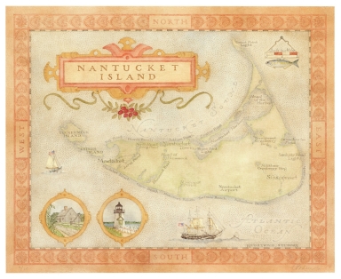
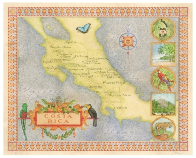


![Karta, predstavliaiushchaia Pol’shu i Moldaviiu s okolo lezhashchimi zemliami, sochinennaia pri Imper.[atorskoi] Akademii Nauk po noveishim izvestiiam Tituliarnym sovetnikom i Ad’iutantom Ivanom Truskotom [i.e. Map Displaying Poland and Moldavia with Surrounding Lands, Compiled Basing on the Latest Data by Titular Councilor, Adjunct Professor Ivan Truskot in the Imperial Academy of Sciences]](https://www.davidrumsey.com/rumsey/Size2/RUMSEY~8~1/205/15642000.jpg)


![新撰臺灣明細全圖 [New, Complete and Detailed Map of Taiwan].](https://www.davidrumsey.com/rumsey/Size2/RUMSEY~8~1/205/15645001.jpg)

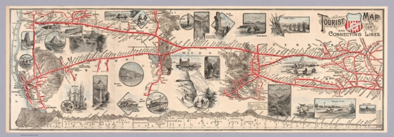


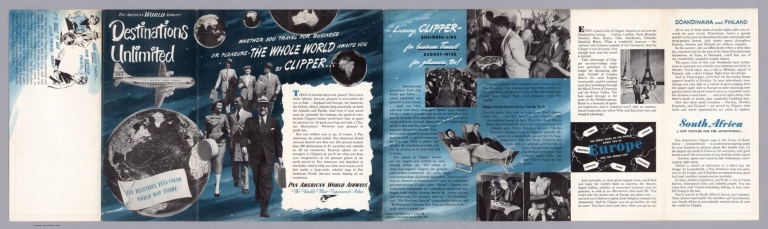
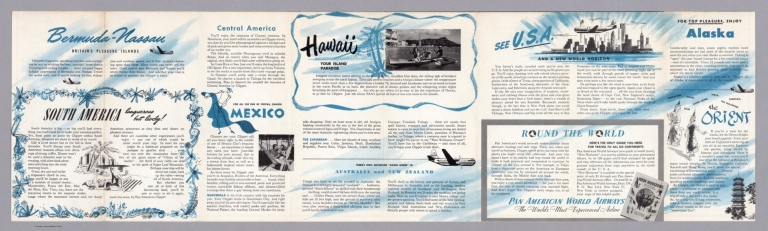


![Karta tamozhennykh uchrezhdenii s graficheskim pokazaniem privoza i vyvoza tovarov, soglasno obzoru vneshnei torgovli za 1873 god [i.e. Map of Custom Offices with Import and Export of Goods Indicated Graphically, According to the 1873 Survey of Foreign Trade]](https://www.davidrumsey.com/rumsey/Size2/RUMSEY~8~1/205/15621000.jpg)


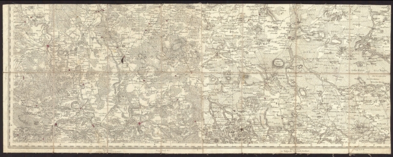


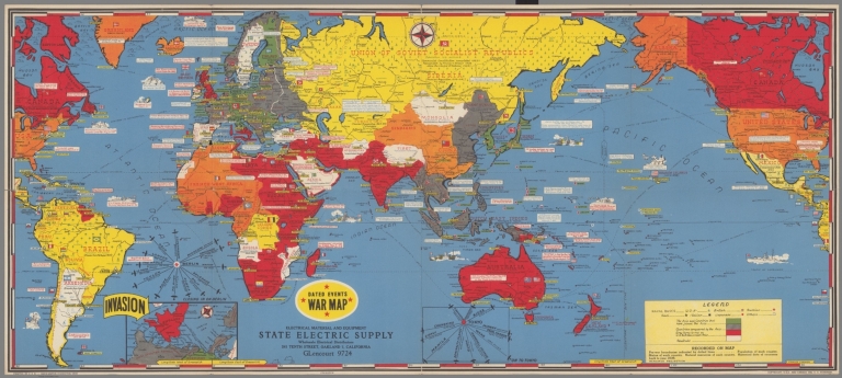


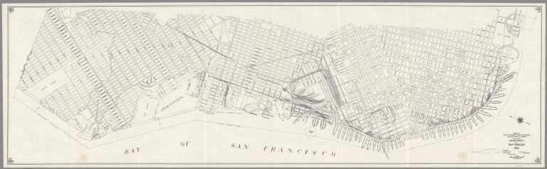


![Yunan Muharebesi'nde Yanya Redif Taburu Binbasi Yanya Vilâyeti'nin kism-i cenûbîsini harita. [Map of Ioannina by Major Halil Ibrahim during the Greco-Turkish War in 1897]](https://www.davidrumsey.com/rumsey/Size1/RUMSEY~8~1/205/15546000.jpg)

![Covers: Skhematicheskaia gornozavodskaia karta zapadnoi i vostochnoi chastei Donetskogo basseina. 1901-1902 [i.e. Schematic Mining Map of Western and Eastern Parts of Donets Basin]](https://www.davidrumsey.com/rumsey/Size2/RUMSEY~8~1/205/15526001.jpg)
![Skhematicheskaia gornozavodskaia karta zapadnoi i vostochnoi chastei Donetskogo basseina. 1901-1902 [i.e. Schematic Mining Map of Western and Eastern Parts of Donets Basin]](https://www.davidrumsey.com/rumsey/Size1/RUMSEY~8~1/205/15526002.jpg)


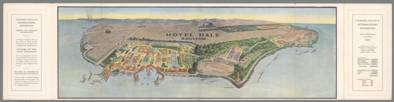
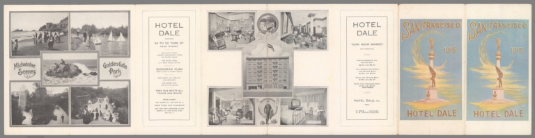


![Covers: PIANTA PANORAMICA DI ROMA [PANORAMA OF ROME]](https://www.davidrumsey.com/rumsey/Size2/RUMSEY~8~1/205/15434003.jpg)
![PIANTA PANORAMICA DI ROMA [PANORAMA OF ROME]](https://www.davidrumsey.com/rumsey/Size2/RUMSEY~8~1/205/15434001.jpg)
![Text: PIANTA PANORAMICA DI ROMA [PANORAMA OF ROME]](https://www.davidrumsey.com/rumsey/Size2/RUMSEY~8~1/205/15434002.jpg)


![[Nairobi:] No. 1 (East Africa Reproduction) Section [Survey Directorate, East Africa Command], April 1946 G.P. No. 2725](https://www.davidrumsey.com/rumsey/Size2/RUMSEY~8~1/205/15446001.jpg)
![[Nairobi:] No. 2 (East Africa Reproduction) Section [Survey Directorate, East Africa Command], April 1946 G.P. No. 2725](https://www.davidrumsey.com/rumsey/Size2/RUMSEY~8~1/205/15446002.jpg)
![[Nairobi:] No. 3 (East Africa Reproduction) Section [Survey Directorate, East Africa Command], April 1946 G.P. No. 2725](https://www.davidrumsey.com/rumsey/Size2/RUMSEY~8~1/205/15446003.jpg)
![[Nairobi:] No. 4 (East Africa Reproduction) Section [Survey Directorate, East Africa Command], April 1946 G.P. No. 2725](https://www.davidrumsey.com/rumsey/Size2/RUMSEY~8~1/205/15446004.jpg)
![[Nairobi:] No. 5 (East Africa Reproduction) Section [Survey Directorate, East Africa Command], April 1946 G.P. No. 2725](https://www.davidrumsey.com/rumsey/Size2/RUMSEY~8~1/205/15446005.jpg)
![[Nairobi:] No. 6 (East Africa Reproduction) Section [Survey Directorate, East Africa Command], April 1946 G.P. No. 2725](https://www.davidrumsey.com/rumsey/Size2/RUMSEY~8~1/205/15446006.jpg)
![Composite: [Nairobi:] No.1-6 (East Africa Reproduction) Section [Survey Directorate, East Africa Command], April 1946 G.P. No. 2725](https://www.davidrumsey.com/rumsey/Size2/RUMSEY~8~1/205/15446007.jpg)


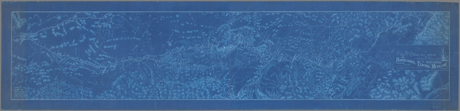
![يمن ولايتى خريطة سى [Yemen Vilâyeti haritasi / Map of Yemen Vilayet].](https://www.davidrumsey.com/rumsey/Size2/RUMSEY~8~1/205/15428000.jpg)


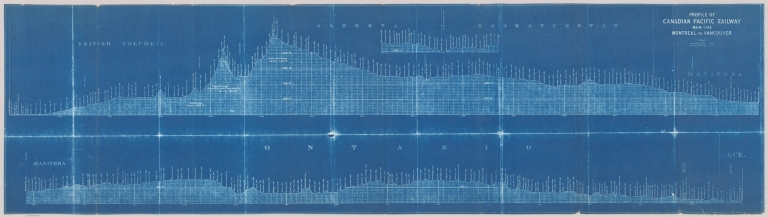


![Covers: نقشه عمومي ايران سياسي، طبيعي، مردم شناسي [General Political, Physical and Anthropological Map of Iran]](https://www.davidrumsey.com/rumsey/Size2/RUMSEY~8~1/205/15406001.jpg)
![نقشه عمومي ايران سياسي، طبيعي، مردم شناسي [General Political, Physical and Anthropological Map of Iran]](https://www.davidrumsey.com/rumsey/Size2/RUMSEY~8~1/205/15406002.jpg)
![Covers: اروپا [Europe]](https://www.davidrumsey.com/rumsey/Size2/RUMSEY~8~1/205/15407001.jpg)
![اروپا [Europe]](https://www.davidrumsey.com/rumsey/Size2/RUMSEY~8~1/205/15407002.jpg)
![Covers: نقشه طبيعي سكسي جزاير اقيانوس كبير [Physical-Political Map of the Islands of the Great Ocean]](https://www.davidrumsey.com/rumsey/Size2/RUMSEY~8~1/205/15408001.jpg)
![نقشه طبيعي سكسي جزاير اقيانوس كبير [Physical-Political Map of the Islands of the Great Ocean]](https://www.davidrumsey.com/rumsey/Size2/RUMSEY~8~1/205/15408002.jpg)
![نقشه تقسيمات كشوري جمهورى اسلامى ايران [Map of Country Divisions of the Islamic Republic of Iran]](https://www.davidrumsey.com/rumsey/Size2/RUMSEY~8~1/205/15409000.jpg)


![[Pictorial Map Cutsheet Advertisement for] Map of the SUrface-Feeding Ducks, Swans and Geese of North America](https://media.davidrumsey.com/MediaManager/srvr?mediafile=/Size3/RUMSEY~8~1/199/15385002.jpg)


![(Sheet 1) Административная карта Грузинской, Армянской и Азербайджанской ССР [Administrative Map of the Georgian, Armenian and Azerbaijani Soviet Socialist Republic]](https://www.davidrumsey.com/rumsey/Size2/RUMSEY~8~1/199/15367001.jpg)
![(Sheet 2) Административная карта Грузинской, Армянской и Азербайджанской ССР [Administrative Map of the Georgian, Armenian and Azerbaijani Soviet Socialist Republic]](https://www.davidrumsey.com/rumsey/Size2/RUMSEY~8~1/199/15367002.jpg)
![Composite: (Sheets 1 & 2) Административная карта Грузинской, Армянской и Азербайджанской ССР [Administrative Map of the Georgian, Armenian and Azerbaijani Soviet Socialist Republic]](https://www.davidrumsey.com/rumsey/Size2/RUMSEY~8~1/199/15367003.jpg)


![[Hittin' the high spots in Montana].](https://www.davidrumsey.com/rumsey/Size2/RUMSEY~8~1/199/14466002.jpg)
![Text: [Hittin' the high spots in Montana]. (1)](https://www.davidrumsey.com/rumsey/Size2/RUMSEY~8~1/199/14466003.jpg)


![Covers: [Pictorial map of Europe].](https://www.davidrumsey.com/rumsey/Size2/RUMSEY~8~1/199/14469001.jpg)
![[Pictorial map of Europe].](https://www.davidrumsey.com/rumsey/Size2/RUMSEY~8~1/199/14469002.jpg)


