|
Author
Stanford, Edward
Full Title
(Covers to) The Instructive Atlas of Modern Geography
List No
15996.001
Note
Date estimated.
Author
Stanford, Edward
Full Title
(Title page to) The Instructive Atlas of Modern Geography
List No
15996.002
Note
Date estimated.
Author
Stanford, Edward
Full Title
The World
List No
15996.004
Note
Date estimated.
Author
Stanford, Edward
Full Title
Eastern Hemisphere
List No
15996.005
Note
Date estimated.
Author
Stanford, Edward
Full Title
Western Hemisphere
List No
15996.006
Note
Date estimated.
Author
Stanford, Edward
Full Title
England
List No
15996.008
Note
Date estimated.
Author
Stanford, Edward
Full Title
Scotland
List No
15996.009
Note
Date estimated.
Author
Stanford, Edward
Full Title
Ireland
List No
15996.010
Note
Date estimated.
Author
Stanford, Edward
Full Title
Australia
List No
15996.020
Note
Date estimated.
Author
Stanford, Edward
Full Title
New Zealand
List No
15996.021
Note
Date estimated.
Author
Logerot, A. (Auguste)
Full Title
(Title Page to) Atlas elémentaire fait pour Monsieur A. Logerot, elève au Pensionnat Professionnel de M. Ph. Pompeé pour servir au cours professé por M. Chatteau. 1856-1857, Ivry sur Seine, 1er et 2th anviée.
List No
14489.002
Note
Title page to Atlas elémentaire ... Handwritten in ink with pencil underlines. (Page number inferred.)
Author
Logerot, A. (Auguste)
Full Title
[Map of Europe.] Ce 8 8bre 1856 ; A. Logerot.
List No
14489.003
Note
Manuscript map representing Europe. Shows select regions, mountain ranges, drainage, coastlines, and islands. Relief shown with hachure lines and shading. Indexed to indicate the names of mountain ranges. Ink, pencil, and watercolor on paper. Indexed to indicate locations such as the Tyrolean Alps and Saint-Gotthard Massif. Map is 24 x 30 cm, on sheet 24 x 32 cm.
Author
Logerot, A. (Auguste)
Full Title
[Map of Europe.] Ce 15 8bre 1856 ; A. Logerot.
List No
14489.004
Note
Manuscript map representing Europe. Shows select regions, cities, mountain ranges, drainage, coastlines, and islands. Relief shown with shading. Features watershed areas, which are differentiated by color. Indexed to indicate the names of mountains and lakes. Ink, pencil, and watercolor on paper. Map is 24 x 30 cm, on sheet 24 x 32 cm.
Author
Logerot, A. (Auguste)
Full Title
Mer Blanche. Ce 23 8bre 1856 ; A. Logerot.
List No
14489.005
Note
Manuscript map representing the White Sea. Shows select regions, cities, mountain ranges, drainage, coastlines, and islands. Relief shown with shading. Ink, pencil, and watercolor on paper. Map is 24 x 30 cm, on sheet 24 x 32 cm.
Author
Logerot, A. (Auguste)
Full Title
Rhin Suisse. Ce 18 Fevrier 1857 ; A. Logerot.
List No
14489.015
Note
Manuscript map representing the watershed of the Rhine River in Switzerland. Shows select regions, cities, mountain ranges, drainage, and bodies of water. Relief shown with shading. Ink, pencil, and watercolor on paper. Map is 22 x 28 cm, on sheet 24 x 31 cm.
Author
Logerot, A. (Auguste)
Full Title
[France.] A. Logerot.
List No
14489.021
Note
Manuscript map representing France. Shows select regions, mountain ranges, drainage, coastlines, and islands. Relief shown with shading. Ink, pencil, and watercolor on paper. Map is 23 x 29 cm, on sheet 24 x 31 cm.
Author
Logerot, A. (Auguste)
Full Title
[Armorican Massif, France.] Ce 98 Mai 1857 ; A. Logerot.
List No
14489.025
Note
Manuscript map representing the Armorican Massif in France. Shows select regions, cities, mountain ranges, drainage, coastlines, and islands. Relief shown with shading. Ink, pencil, and watercolor on paper. Map is 21 x 29 cm, on sheet 24 x 31 cm.
Author
Logerot, A. (Auguste)
Full Title
[Loire River.] A. Logerot.
List No
14489.026
Note
Manuscript map representing the Loire River basin in France. Shows select regions, cities, mountain ranges, drainage, coastlines, and islands. Relief shown with shading. Ink, pencil, and watercolor on paper. Map is 23 x 30 cm, on sheet 23 x 30 cm.
Author
Logerot, A. (Auguste)
Full Title
[Loire River.] A. Logerot.
List No
14489.027
Note
Manuscript map representing the Loire River basin in France. Shows select regions, cities, mountain ranges, drainage, coastlines, and islands. Relief shown with shading. Ink, pencil, and watercolor on paper. Map is 23 x 29 cm, on sheet 23 x 30 cm.
Author
Logerot, A. (Auguste)
Full Title
Asie mineure. A. Logerot.
List No
14489.038
Note
Manuscript map representing Asia Minor. Shows select regions, cities, mountain ranges, drainage, coastlines, and islands. Relief shown with shading. Ink, pencil, and watercolor on paper. Map is 21 x 27 cm, on sheet 24 x 31 cm.
Author
Logerot, A. (Auguste)
Full Title
Afrique. A. Logerot ; Ce 8 Janvier 1856.
List No
14489.041
Note
Manuscript map representing Africa. Shows select regions, cities, mountain ranges, deserts, drainage, coastlines, and islands. Relief shown with shading. Ink, pencil, and watercolor on paper. Map is 22 x 28 cm, on sheet 24 x 31 cm. (Page number written as “43” for page 44 in volume.)
Author
Logerot, A. (Auguste)
Full Title
Amerique du Noro. A. Logerot.
List No
14489.042
Note
Manuscript map representing North America. Shows select regions, mountain ranges, coastlines, and islands. Ink, pencil, and watercolor on paper. Map is 30 x 23 cm, on sheet 30 x 23 cm.
Author
Logerot, A. (Auguste)
Full Title
Amérique Septentrionale. A. Logerot.
List No
14489.043
Note
Manuscript map representing North America. Shows select regions, mountain ranges, drainage, bodies of water, coastlines, and islands. Relief shown with shading. Ink, pencil, and watercolor on paper. Map is 27 x 23 cm, on sheet 31 x 23 cm.
Author
Logerot, A. (Auguste)
Full Title
[North and South America.] A. Logerot.
List No
14489.044
Note
Manuscript map representing North and South America. Shows select regions, mountain ranges, drainage, bodies of water, coastlines, and islands. Relief shown with shading. Ink, pencil, and watercolor on paper. Map is 31 x 23 cm, on sheet 31 x 23 cm.
Author
Logerot, A. (Auguste)
Full Title
[South America.] A. Logerot.
List No
14489.045
Note
Manuscript map representing South America. Shows select regions, mountain ranges, drainage, coastlines, and islands. Relief shown with shading. Ink, pencil, and watercolor on paper. Map is 22 x 28 cm, on sheet 30 x 23 cm.
Author
Logerot, A. (Auguste)
Full Title
Océanie. A. Logerot.
List No
14489.046
Note
Manuscript map representing Oceania. Shows select regions, cities, mountain ranges, drainage, coastlines, and islands. Relief shown with shading. Ink, pencil, and watercolor on paper. Map is 22 x 28 cm, on sheet 24 x 30 cm.
Author
Peabody, Elizabeth Palmer
Full Title
Christian Era
List No
15895.000
Author
[Sutnar, Ladislav, Tschinkel, Augustin]
Full Title
(Covers to) Mala vlastiveda [The Little Civics Reader]
List No
15867.001
Author
[Sutnar, Ladislav, Tschinkel, Augustin]
Full Title
(Title page to) Mala vlastiveda [The Little Civics Reader]
List No
15867.002
Author
[Sutnar, Ladislav, Tschinkel, Augustin]
Full Title
Naše republika (Our Country)
List No
15867.003
Author
[Sutnar, Ladislav, Tschinkel, Augustin]
Full Title
Hory a Feky (Mountains and Rivers) (with) Lesy a lázne (Forests and Land)
List No
15867.004
Author
[Sutnar, Ladislav, Tschinkel, Augustin]
Full Title
Železnice (Railways) (with) Národnosti (Nationalities)
List No
15867.005
Author
[Sutnar, Ladislav, Tschinkel, Augustin]
Full Title
Minulest (The Past) (with) Naše země v 9. a 10. století (Our country in the 9th and 10th centuries)
List No
15867.006
Author
[Sutnar, Ladislav, Tschinkel, Augustin]
Full Title
Ríše Přemysla II. Otakara (The Empire of Přemysl II Otakara) (with) Ríše Václava lI. a Václava IIl. (The Empire of Wenceslas I. and Wenceslas III)
List No
15867.007
Author
[Sutnar, Ladislav, Tschinkel, Augustin]
Full Title
Riše Karlova (Karlova's Empire) (with) Rakousko-Uhersko (Austria Hungary)
List No
15867.008
Author
[Sutnar, Ladislav, Tschinkel, Augustin]
Full Title
Boj za svobodu (The Fight for Freedom) (with) Vznik Československé republiky (Emergence of the Czechoslovak Republic)
List No
15867.009
Author
[Sutnar, Ladislav, Tschinkel, Augustin]
Full Title
Přítomnost (Presence) (with) Obyvatelstvo podle národnosti (Population by Nationality)
List No
15867.010
Author
[Sutnar, Ladislav, Tschinkel, Augustin]
Full Title
Náboženství a vyznání (Religion and Confession) (with) Zaměstnání obyvatelstva (Employment of the population)
List No
15867.011
Author
[Sutnar, Ladislav, Tschinkel, Augustin]
Full Title
Co se dováží (What is Imported) (with) Co se vyváží (What is Exported)
List No
15867.012
Author
[Sutnar, Ladislav, Tschinkel, Augustin]
Full Title
Domácí zvířata (Domestic Animals) (with) Uhelné pánve a oblasti textilního průmyslu (Coal basins and textile industry areas)
List No
15867.013
Author
[Sutnar, Ladislav, Tschinkel, Augustin]
Full Title
Vývoj automobilové dopravy( Development of automobile transport) (with) Státní rozpočet (State budget)
List No
15867.014
Author
[Sutnar, Ladislav, Tschinkel, Augustin]
Full Title
Města (Cities) (with) Města podie velikosti (Cities by Size)
List No
15867.015
Author
[Sutnar, Ladislav, Tschinkel, Augustin]
Full Title
Praha (Prague) (with) Počet obyvatelstva Prahy (Population of Prague) Praha asi roku 1400 (Prague around 1400) (and) Praha dnešní (Today's Prague)
List No
15867.016
Author
[Sutnar, Ladislav, Tschinkel, Augustin]
Full Title
Krajané za hranicemi (Compatriots abroad) (with) Počet krajanů za hranicemi podle zemi (Number of compatriots abroad by country)
List No
15867.017
Author
[Sutnar, Ladislav, Tschinkel, Augustin]
Full Title
Malá vlastivěda Sestavil a upravil Ladislav Sutnar (The Little Civics Reader Compiled and edited by Ladislav Sutnar)
List No
15867.018
Note
Further states: The text was written and the historical part by Hidil Bedrich Mendl. Maps and diagrams were drawn by Augustin Tschinkel. The diagrams were created according to the statistical data of the State Statistical Office. The book, prepared on the basis of the prior approval of the Ministry of Education and National Education of January 16, 1931, No. 136/1931 pres., was approved by the Ministry of Education and Culture by Decree of December 31, 1932, No. 160.414/32-l/1, as a teaching aid for general and burgher schools.
Author
Finney, Ethel
Full Title
(Covers to) [Egyptian/German manuscript schoolgirl atlas].
List No
14317.001
Note
Covers to school atlas, drawn by Ethel Finney at the Deutsche Schule zu Alexandrien (German School in Alexandria) in 1900. Blue paper covers; bound with thread. Bookplate on cover with Finney's signature, date and class (II).
Author
Finney, Ethel
Full Title
Alexandrien.
List No
14317.002
Note
Manuscript map of Alexandria, Egypt. Shows streets and drainage. Drawn in graphite and colored blue pencil, with a penciled grid beneath drawing. Lettering in cursive. Map is 17 x 21 cm, on sheet 20 x 25 cm.
Author
Finney, Ethel
Full Title
Nil - Delta.
List No
14317.003
Note
Two manuscript maps of the Nile River Delta, Egypt. Maps show cities, railways, topography, lakes, drainage and coastline. Relief shown in hachures. Drawn in graphite, with a penciled grid beneath drawing. Descriptive text in lower margin. Lettering in cursive. Together, maps are 36 x 21 cm, on facing sheets, together 40 x 25 cm.
Author
Finney, Ethel
Full Title
Kairo.
List No
14317.004
Note
Two manuscript maps of Cairo, Egypt (top), and Haizer, Algeria (bottom). Maps show railways, streets, topography, lakes and drainage. Relief shown in hachures. Drawn in graphite, ink and watercolor. Descriptive text in lower margin of top map. Lettering in cursive. Together, maps are 39 x 25 cm, on facing sheets, together 40 x 25 cm.
Author
Finney, Ethel
Full Title
[Nile River Delta].
List No
14317.005
Note
Two manuscript maps of the Nile River Delta, Egypt. Maps show cities, railways, lakes, drainage and coastline. Drawn in ink and watercolor. Lettering in cursive. Together, maps are 37 x 24 cm, on facing sheets, together 40 x 25 cm.
Author
Finney, Ethel
Full Title
[Nile River, to Lake Victoria]. Alexandrien, den 22/3/1900. E. F.
List No
14317.006
Note
Manuscript map of the Nile River to Lake Victoria, Egypt. Shows cities, topography, lakes, drainage and coastlines. Relief shown in hachures. Drawn in ink and watercolor. Lettering in cursive. Map is 30 x 18 cm, on facing sheets, together 40 x 25 cm.
Author
Finney, Ethel
Full Title
Nil (bis Assouan).
List No
14317.007
Note
Manuscript map of the Nile River to Aswan, Egypt. Shows cities, seas, lakes, drainage and coastlines. Drawn in ink and watercolor. Lettering in cursive. Map is 16 x 21 cm, on sheet 20 x 25 cm.
Author
Finney, Ethel
Full Title
[Watercolor palette].
List No
14317.008
Note
Watercolor palette tested through a series of whimsical brushstrokes. On final page of atlas.
Author
Gallardo y Rionda, J.P.
Full Title
(Covers to) Cartilla Geografica del Distrito Federal (Geographical booklet of the federal district, arranged expressly for schools, by the engineer J.P. Gallardo y Rionda... corrected and enlarged. Sixth edition. 1888)
List No
15466.001
Author
Gallardo y Rionda, J.P.
Full Title
(Title page to) Cartilla Geografica del Distrito Federal (Geographical booklet of the federal district, arranged expressly for schools, by the engineer J.P. Gallardo y Rionda... corrected and enlarged. Sixth edition. 1888)
List No
15466.002
Author
Gallardo y Rionda, J.P.
Full Title
(Text page to) Cartilla Geografica del Distrito Federal (Geographical booklet of the federal district, arranged expressly for schools, by the engineer J.P. Gallardo y Rionda... corrected and enlarged. Sixth edition. 1888)
List No
15466.003
Author
Gallardo y Rionda, J.P.
Full Title
(Text page to) Cartilla Geografica del Distrito Federal (Geographical booklet of the federal district, arranged expressly for schools, by the engineer J.P. Gallardo y Rionda... corrected and enlarged. Sixth edition. 1888)
List No
15466.004
Author
Gallardo y Rionda, J.P.
Full Title
(Text page to) Cartilla Geografica del Distrito Federal (Geographical booklet of the federal district, arranged expressly for schools, by the engineer J.P. Gallardo y Rionda... corrected and enlarged. Sixth edition. 1888)
List No
15466.005
Author
Gallardo y Rionda, J.P.
Full Title
(Text page to) Cartilla Geografica del Distrito Federal (Geographical booklet of the federal district, arranged expressly for schools, by the engineer J.P. Gallardo y Rionda... corrected and enlarged. Sixth edition. 1888)
List No
15466.006
Author
Gallardo y Rionda, J.P.
Full Title
(Composite text to) Cartilla Geografica del Distrito Federal (Geographical booklet of the federal district, arranged expressly for schools, by the engineer J.P. Gallardo y Rionda... corrected and enlarged. Sixth edition. 1888)
List No
15466.007
Author
Gallardo y Rionda, J.P.
Full Title
Mapa Mudo del Distrito Federal.
List No
15466.008
Note
Blank map to be filled in by students from studying the following full printed map of the same area.
Author
Gallardo y Rionda, J.P.
Full Title
Carta Geografica del Distrito Federal.
List No
15466.009
Author
Byrne, Oliver
Full Title
The Young Geometrician; or Practical Geometry without Compasses.
List No
15465.001
Author
Byrne, Oliver
Full Title
(Title page to) The Young Geometrician; or Practical Geometry without Compasses.
List No
15465.003
Author
Byrne, Oliver
Full Title
(Text page to) The Young Geometrician; or Practical Geometry without Compasses.
List No
15465.004
Author
Byrne, Oliver
Full Title
(Text page to) The Young Geometrician; or Practical Geometry without Compasses.
List No
15465.005
Author
Byrne, Oliver
Full Title
Pages 1, 2. The Young Geometrician; or Practical Geometry without Compasses.
List No
15465.006
Author
Byrne, Oliver
Full Title
Pages 3, 4. The Young Geometrician; or Practical Geometry without Compasses.
List No
15465.007
Author
Byrne, Oliver
Full Title
Problem II. The Young Geometrician; or Practical Geometry without Compasses.
List No
15465.011
Author
Byrne, Oliver
Full Title
Problem III. The Young Geometrician; or Practical Geometry without Compasses.
List No
15465.012
Author
Byrne, Oliver
Full Title
Problem IV. The Young Geometrician; or Practical Geometry without Compasses.
List No
15465.013
Author
Byrne, Oliver
Full Title
Problem X. The Young Geometrician; or Practical Geometry without Compasses.
List No
15465.019
Author
Byrne, Oliver
Full Title
Problem XVI. The Young Geometrician; or Practical Geometry without Compasses.
List No
15465.025
Author
Byrne, Oliver
Full Title
Problem XVII. The Young Geometrician; or Practical Geometry without Compasses.
List No
15465.026
Author
Byrne, Oliver
Full Title
Problem XVIII. The Young Geometrician; or Practical Geometry without Compasses.
List No
15465.027
Author
Byrne, Oliver
Full Title
Problem XX. The Young Geometrician; or Practical Geometry without Compasses.
List No
15465.029
Author
Byrne, Oliver
Full Title
Problem XXI. The Young Geometrician; or Practical Geometry without Compasses.
List No
15465.030
Author
Byrne, Oliver
Full Title
Problem XXII. The Young Geometrician; or Practical Geometry without Compasses.
List No
15465.031
Author
Arrowsmith, Samuel
Full Title
Map of Africa Constructed for the Use of the National Schools of Ireland, under the Direction of the Commissioners, by S. Arrowsmith, Hydrographer to the King
List No
15196.000
Author
[A.J. Nystrom & Co., Dimond, Stanley, Beamer, Miles]
Full Title
(Covers to) Citizenship For Democracy Charts
List No
15184.001
Author
[A.J. Nystrom & Co., Dimond, Stanley, Beamer, Miles]
Full Title
1. Uncle Sam Grows Up
List No
15184.002
Author
[A.J. Nystrom & Co., Dimond, Stanley, Beamer, Miles]
Full Title
2. The United States - A Good Place to Live
List No
15184.003
Author
[A.J. Nystrom & Co., Dimond, Stanley, Beamer, Miles]
Full Title
3. Growth of Communication by Generations
List No
15184.004
Author
[A.J. Nystrom & Co., Dimond, Stanley, Beamer, Miles]
Full Title
4. Growth of Transportation by Generations
List No
15184.005
Author
[A.J. Nystrom & Co., Dimond, Stanley, Beamer, Miles]
Full Title
5. The People of the United States
List No
15184.006
Author
[A.J. Nystrom & Co., Dimond, Stanley, Beamer, Miles]
Full Title
6. Population Trends
List No
15184.007
Author
[A.J. Nystrom & Co., Dimond, Stanley, Beamer, Miles]
Full Title
7. Immigration and Naturalization
List No
15184.008
Author
[A.J. Nystrom & Co., Dimond, Stanley, Beamer, Miles]
Full Title
8. How Crowded are the Countries of the World
List No
15184.009
Author
[A.J. Nystrom & Co., Dimond, Stanley, Beamer, Miles]
Full Title
9. Living in a Democratic Country
List No
15184.010
Author
[A.J. Nystrom & Co., Dimond, Stanley, Beamer, Miles]
Full Title
10. Living in a Totalitarian or Communistic Country
List No
15184.011
Author
[A.J. Nystrom & Co., Dimond, Stanley, Beamer, Miles]
Full Title
11. How Communists Gain Control of Noncommunist Governments
List No
15184.012
Author
[A.J. Nystrom & Co., Dimond, Stanley, Beamer, Miles]
Full Title
12. Freedom of Enterprise
List No
15184.013
Author
[A.J. Nystrom & Co., Dimond, Stanley, Beamer, Miles]
Full Title
13. Energy of the United States
List No
15184.014
Author
[A.J. Nystrom & Co., Dimond, Stanley, Beamer, Miles]
Full Title
14. The Kinds of Work We Do
List No
15184.015
Author
[A.J. Nystrom & Co., Dimond, Stanley, Beamer, Miles]
Full Title
15. How the Social Security Administration Works
List No
15184.016
Author
[A.J. Nystrom & Co., Dimond, Stanley, Beamer, Miles]
Full Title
16. Division of United States Income
List No
15184.017
Author
Hossein
Full Title
(Covers to) جغرافیای عمومی اطلسی .اثر حسين = Atlas of general geography. By Hussein : Rushdieh Askarieh Schools of Geography, Military Service. Istanbul 1300 (1923).
List No
13686.001
Author
Hossein
Full Title
(Title Page to) جغرافیای عمومی اطلسی .اثر حسين = Atlas of general geography. By Hussein : Rushdieh Askarieh Schools of Geography, Military Service. Istanbul 1300 (1923).
List No
13686.002
Author
Hossein
Full Title
انکلتره = England. جغرافیای عمومی اطلسی = Atlas of general geography. Istanbul 1300 (1923).
List No
13686.003
Note
Color outline map of England, Ireland and Scotland. Relief shown by hachures.
Author
Hossein
Full Title
انکلتره = England. جغرافیای عمومی اطلسی = Atlas of general geography. Istanbul 1300 (1923).
List No
13686.004
Note
Color political map of England, Ireland and Scotland.
Author
Hossein
Full Title
(Political map of the Northwestern Europe). جغرافیای عمومی اطلسی = Atlas of general geography. Istanbul 1300 (1923).
List No
13686.005
Note
Color political map of Netherlands, Belgium and Luxembourg.
Author
Hossein
Full Title
فرانسه = France. جغرافیای عمومی اطلسی = Atlas of general geography. Istanbul 1300 (1923).
List No
13686.006
Note
Color outline map of France.
Author
Hossein
Full Title
فرانسه = France. جغرافیای عمومی اطلسی = Atlas of general geography. Istanbul 1300 (1923).
List No
13686.007
Note
Color political map of France.
Author
Hossein
Full Title
(Political map of Spain and Portugal). جغرافیای عمومی اطلسی = Atlas of general geography. Istanbul 1300 (1923).
List No
13686.008
Note
Color political map of Spain and Portugal.
Author
Hossein
Full Title
(Outline map of Spain and Portugal). جغرافیای عمومی اطلسی = Atlas of general geography. Istanbul 1300 (1923).
List No
13686.009
Note
Outline map of Spain and Portugal.
Author
三宅秀一編 [Shūichi MIYAKE].
Full Title
萬國地誌畧暗射掲圖 / 亜非利加之部 [Topographical Record of the Nations / Africa].
List No
15156.000
Note
Meiji 9 [1876].
Author
三宅秀一編 [Shūichi MIYAKE].
Full Title
萬國地誌畧暗射掲圖 / 亜細亜之部 [Topographical Record of the Nations / Asia].
List No
15157.000
Note
Meiji 9 [1876].
Author
شكوفه مقبل [Şukufe Mukbil]
Full Title
(Covers to) (Atlas of the World)
List No
10992.001
Note
Dimensions are sheet size.
Author
شكوفه مقبل [Şukufe Mukbil]
Full Title
(Rivers of Europe)
List No
10992.002
Note
Dimensions are sheet size.
Author
شكوفه مقبل [Şukufe Mukbil]
Full Title
(Political map of Europe)
List No
10992.003
Note
Dimensions are sheet size.
Author
شكوفه مقبل [Şukufe Mukbil]
Full Title
(Bulgaria)
List No
10992.004
Note
Dimensions are sheet size.
Author
شكوفه مقبل [Şukufe Mukbil]
Full Title
(Serbia)
List No
10992.005
Note
Dimensions are sheet size.
Author
شكوفه مقبل [Şukufe Mukbil]
Full Title
(Romania)
List No
10992.006
Note
Dimensions are sheet size.
Author
شكوفه مقبل [Şukufe Mukbil]
Full Title
(Greece)
List No
10992.007
Note
Dimensions are sheet size.
Author
شكوفه مقبل [Şukufe Mukbil]
Full Title
(Montenegro)
List No
10992.008
Note
Dimensions are sheet size.
Author
شكوفه مقبل [Şukufe Mukbil]
Full Title
(European Russia with railroads)
List No
10992.009
Note
Dimensions are sheet size.
Author
شكوفه مقبل [Şukufe Mukbil]
Full Title
(Austro-Hungary)
List No
10992.010
Note
Dimensions are sheet size.
Author
شكوفه مقبل [Şukufe Mukbil]
Full Title
(Germany)
List No
10992.011
Note
Dimensions are sheet size.
Author
شكوفه مقبل [Şukufe Mukbil]
Full Title
(France)
List No
10992.012
Note
Dimensions are sheet size.
Author
شكوفه مقبل [Şukufe Mukbil]
Full Title
(Great Britain and Ireland)
List No
10992.013
Note
Dimensions are sheet size.
Author
شكوفه مقبل [Şukufe Mukbil]
Full Title
(Italy with railroads)
List No
10992.014
Note
Dimensions are sheet size.
Author
شكوفه مقبل [Şukufe Mukbil]
Full Title
(Scandinavia)
List No
10992.015
Note
Dimensions are sheet size.
Author
شكوفه مقبل [Şukufe Mukbil]
Full Title
(Iceland)
List No
10992.016
Note
Dimensions are sheet size.
Author
شكوفه مقبل [Şukufe Mukbil]
Full Title
(Denmark
List No
10992.017
Note
Dimensions are sheet size.
Author
شكوفه مقبل [Şukufe Mukbil]
Full Title
(Luxemburg with railroads)
List No
10992.018
Note
Dimensions are sheet size.
Author
شكوفه مقبل [Şukufe Mukbil]
Full Title
(Benelux)
List No
10992.019
Note
Dimensions are sheet size.
Author
شكوفه مقبل [Şukufe Mukbil]
Full Title
(Switzerland)
List No
10992.020
Note
Dimensions are sheet size.
Author
شكوفه مقبل [Şukufe Mukbil]
Full Title
(The Caucasus with railroads)
List No
10992.021
Note
Dimensions are sheet size.
Author
شكوفه مقبل [Şukufe Mukbil]
Full Title
(Iran)
List No
10992.022
Note
Dimensions are sheet size.
Author
شكوفه مقبل [Şukufe Mukbil]
Full Title
(Afghanistan and Pakistan)
List No
10992.023
Note
Dimensions are sheet size.
Author
شكوفه مقبل [Şukufe Mukbil]
Full Title
(Asia)
List No
10992.024
Note
Dimensions are sheet size.
Author
شكوفه مقبل [Şukufe Mukbil]
Full Title
(China and Korea)
List No
10992.025
Note
Dimensions are sheet size.
Author
Ramzi, Muhammad
Full Title
(Outline map of World hemispheres). Umumi jughrafia atlasi = Atlas of general geography. Assar Muhammad Ramzi, Maktab Harbiye Matbaa si. Mulayiyuh sanah 1328 (1910).
List No
13532.002
Note
Outline map of world hemispheres by continent. Includes inset map of the world and view of comparative heights of mountains in the world.
Author
Ramzi, Muhammad
Full Title
(Outline map of World). Umumi jughrafia atlasi = Atlas of general geography. Assar Muhammad Ramzi, Maktab Harbiye Matbaa si. Mulayiyuh sanah 1328 (1910).
List No
13532.003
Note
Outline map of the world by continent.
Author
Ramzi, Muhammad
Full Title
(Outline map of Europe). Umumi jughrafia atlasi = Atlas of general geography. Assar Muhammad Ramzi, Maktab Harbiye Matbaa si. Mulayiyuh sanah 1328 (1910).
List No
13532.004
Note
Outline map of Europe.
Author
Ramzi, Muhammad
Full Title
(Outline map of Balkan Peninsula). Umumi jughrafia atlasi = Atlas of general geography. Assar Muhammad Ramzi, Maktab Harbiye Matbaa si. Mulayiyuh sanah 1328 (1910).
List No
13532.005
Note
Outline map of Balkan Peninsula. Includes 2 insets. Extend from Romania in the north to Crete Island in south. Shows political boundaries and roads. Some boundaries, countries and cities are marked in with pen.
Author
Ramzi, Muhammad
Full Title
(Outline map of Balkan Peninsula). Umumi jughrafia atlasi = Atlas of general geography. Assar Muhammad Ramzi, Maktab Harbiye Matbaa si. Mulayiyuh sanah 1328 (1910).
List No
13532.006
Note
Outline map of Balkan Peninsula. Includes 2 insets. Extend from Romania in the north to Crete Island in south.
Author
Ramzi, Muhammad
Full Title
(Outline map of Italy). Umumi jughrafia atlasi = Atlas of general geography. Assar Muhammad Ramzi, Maktab Harbiye Matbaa si. Mulayiyuh sanah 1328 (1910).
List No
13532.007
Note
Outline map of Italy. Includes 2 insets.
Author
Ramzi, Muhammad
Full Title
(Outline map of Italy). Umumi jughrafia atlasi = Atlas of general geography. Assar Muhammad Ramzi, Maktab Harbiye Matbaa si. Mulayiyuh sanah 1328 (1910).
List No
13532.008
Note
Outline map of Italy. Includes 2 insets. Copy 2.
Author
[Perthes, Justus, Chile. Ministerio de Instrucción Pública., Fuenzalida, José del C.]
Full Title
(Covers to) Atlas de la República de Chile.
List No
14325.001
Note
Covers to Atlas de la República de Chile. Bound in tan-colored board, with brown linen spine. Front cover provides title, and includes the national shield of the Republic of Chile, which includes the national motto: Por la razon o la fuerza [= By reason or force]. The phrase dates back to the time of Chilean independence and, because of its meaning, is considered a modern version of the Latin motto: Aut consilio aut ense [= or by advice or by sword].
Author
[Perthes, Justus, Chile. Ministerio de Instrucción Pública., Fuenzalida, José del C.]
Full Title
Mapa escolar de Chile, mandado hacer por órden del Señor Ministro de Instruccion Pública don domingo amunátegui solar durante la Presidencia del Exmo Señor Don Pedro Montt. Construido segun los últimos datos jeográficos en la Inspeccion Jral. de Jeografía Iminas de la Direccion de Obras Públicas ; injeniero jefe, José del C. Fuenzalida. Litografía é impresion de Justus Perthes, Gotha, 1911. (1)
List No
14325.002
Note
School map of Chile. First of nine double-plate sheets, bound together within Atlas de la República de Chile. Ninth sheet includes a bar scale, legend and title cartouche, with imprint, as well as a pictorial vignette of a mountainous scene, featuring a smoking volcano and an Andean Condor, the national bird of Chile. Map shows cities, railroads (including those under construction), topography, glaciers, lakes, drainage, salt flats, coastlines, islands and soundings. Relief and depths shown with color coding. Latitudinal and longitudinal lines, with Greenwich as the prime meridian. Colored lithograph. Each sheet is 34 x 48 cm, on sheet 39 x 54.
Author
[Perthes, Justus, Chile. Ministerio de Instrucción Pública., Fuenzalida, José del C.]
Full Title
Proyeccion vertical, vista panorámica : Entre Arica i Valle Sajama -- Proyeccion vertical, vista panorámica : Frente a Iquique.
List No
14325.003
Note
Two profile maps of the Arica, Sajama and Iquique areas in Chile. Titles translate to: Vertical projection, panoramic view : Between Arica and Sajama Valley -- Vertical projection, panoramic view : In front of Iquique. Maps show topography (including volcanoes), lakes, drainage and sea level, as well as the underwater slope. Mountain peaks featured, labeled with names and heights. Relief shown pictorially and with hacures. Maps each include coordinate points for latitude, as well as statements for both horizontal and vertical scale. Colored lithograph. Together, maps are 23 x 35 cm, on sheet 27 x 39 cm.
Author
[Perthes, Justus, Chile. Ministerio de Instrucción Pública., Fuenzalida, José del C.]
Full Title
Mapa escolar de Chile, mandado hacer por órden del Señor Ministro de Instruccion Pública don domingo amunátegui solar durante la Presidencia del Exmo Señor Don Pedro Montt. Construido segun los últimos datos jeográficos en la Inspeccion Jral. de Jeografía Iminas de la Direccion de Obras Públicas ; injeniero jefe, José del C. Fuenzalida. Litografía é impresion de Justus Perthes, Gotha, 1911. (2)
List No
14325.004
Note
School map of Chile. Second of nine double-plate sheets, bound together within Atlas de la República de Chile. Ninth sheet includes a bar scale, legend and title cartouche, with imprint, as well as a pictorial vignette of a mountainous scene, featuring a smoking volcano and an Andean Condor, the national bird of Chile. Map shows cities, railroads (including those under construction), topography, glaciers, lakes, drainage, salt flats, coastlines, islands and soundings. Relief and depths shown with color coding. Latitudinal and longitudinal lines, with Greenwich as the prime meridian. This sheet has inset map: [Is. Sn. Félix ; I. Sn. Ambrosio]. Colored lithograph. Each sheet is 34 x 48 cm, on sheet 39 x 54.
Author
[Perthes, Justus, Chile. Ministerio de Instrucción Pública., Fuenzalida, José del C.]
Full Title
Proyeccion vertical, vista panorámica : Altura de Quillagua -- Proyeccion vertical, vista panorámica : Frente a Antofagasta.
List No
14325.005
Note
Two profile maps of the Antofagasta and Quillagua areas in Chile. Titles translate to: Vertical projection, panoramic view : Quillagua height -- Vertical projection, panoramic view : In front of Antofagasta. Maps show topography (including volcanoes), lakes, drainage and sea level, as well as the underwater slope. Mountain peaks featured, labeled with names and heights. Relief shown pictorially and with hacures. Maps each include coordinate points for latitude, as well as statements for both horizontal and vertical scale. Colored lithograph. Together, maps are 23 x 35 cm, on sheet 27 x 39 cm.
Author
[Perthes, Justus, Chile. Ministerio de Instrucción Pública., Fuenzalida, José del C.]
Full Title
Mapa escolar de Chile, mandado hacer por órden del Señor Ministro de Instruccion Pública don domingo amunátegui solar durante la Presidencia del Exmo Señor Don Pedro Montt. Construido segun los últimos datos jeográficos en la Inspeccion Jral. de Jeografía Iminas de la Direccion de Obras Públicas ; injeniero jefe, José del C. Fuenzalida. Litografía é impresion de Justus Perthes, Gotha, 1911. (3)
List No
14325.006
Note
School map of Chile. Third of nine double-plate sheets, bound together within Atlas de la República de Chile. Ninth sheet includes a bar scale, legend and title cartouche, with imprint, as well as a pictorial vignette of a mountainous scene, featuring a smoking volcano and an Andean Condor, the national bird of Chile. Map shows cities, railroads (including those under construction), topography, glaciers, lakes, drainage, salt flats, coastlines, islands and soundings. Relief and depths shown with color coding. Latitudinal and longitudinal lines, with Greenwich as the prime meridian. This sheet has inset map: [Isla de Pascua]. Colored lithograph. Each sheet is 34 x 48 cm, on sheet 39 x 54.
Author
[Perthes, Justus, Chile. Ministerio de Instrucción Pública., Fuenzalida, José del C.]
Full Title
Mapa escolar de Chile, mandado hacer por órden del Señor Ministro de Instruccion Pública don domingo amunátegui solar durante la Presidencia del Exmo Señor Don Pedro Montt. Construido segun los últimos datos jeográficos en la Inspeccion Jral. de Jeografía Iminas de la Direccion de Obras Públicas ; injeniero jefe, José del C. Fuenzalida. Litografía é impresion de Justus Perthes, Gotha, 1911. (4)
List No
14325.007
Note
School map of Chile. Fourth of nine double-plate sheets, bound together within Atlas de la República de Chile. Ninth sheet includes a bar scale, legend and title cartouche, with imprint, as well as a pictorial vignette of a mountainous scene, featuring a smoking volcano and an Andean Condor, the national bird of Chile. Map shows cities, railroads (including those under construction), topography, glaciers, lakes, drainage, salt flats, coastlines, islands and soundings. Relief and depths shown with color coding. Latitudinal and longitudinal lines, with Greenwich as the prime meridian. This sheet has inset map: [I. Masafuera ; I. de Juan Fernandez ; I. Sta. Clara]. Colored lithograph. Each sheet is 34 x 48 cm, on sheet 39 x 54.
Author
[Perthes, Justus, Chile. Ministerio de Instrucción Pública., Fuenzalida, José del C.]
Full Title
Proyeccion vertical, vista panorámica : Frente a Taltal -- Proyeccion vertical, vista panorámica : Frente a Copiapó.
List No
14325.008
Note
Two profile maps of the Taltal and Copiapó areas in Chile. Titles translate to: Vertical projection, panoramic view : In front of Taltal -- Vertical projection, panoramic view : In front of Copiapó. Maps show topography (including volcanoes), lakes, drainage and sea level, as well as the underwater slope. Mountain peaks featured, labeled with names and heights. Relief shown pictorially and with hacures. Maps each include coordinate points for latitude, as well as statements for both horizontal and vertical scale. Colored lithograph. Together, maps are 23 x 35 cm, on sheet 27 x 39 cm.
Author
[Perthes, Justus, Chile. Ministerio de Instrucción Pública., Fuenzalida, José del C.]
Full Title
Mapa escolar de Chile, mandado hacer por órden del Señor Ministro de Instruccion Pública don domingo amunátegui solar durante la Presidencia del Exmo Señor Don Pedro Montt. Construido segun los últimos datos jeográficos en la Inspeccion Jral. de Jeografía Iminas de la Direccion de Obras Públicas ; injeniero jefe, José del C. Fuenzalida. Litografía é impresion de Justus Perthes, Gotha, 1911. (5)
List No
14325.009
Note
School map of Chile. Fifth of nine double-plate sheets, bound together within Atlas de la República de Chile. Ninth sheet includes a bar scale, legend and title cartouche, with imprint, as well as a pictorial vignette of a mountainous scene, featuring a smoking volcano and an Andean Condor, the national bird of Chile. Map shows cities, railroads (including those under construction), topography, glaciers, lakes, drainage, salt flats, coastlines, islands and soundings. Relief and depths shown with color coding. Latitudinal and longitudinal lines, with Greenwich as the prime meridian. Colored lithograph. Each sheet is 34 x 48 cm, on sheet 39 x 54.
Author
[Perthes, Justus, Chile. Ministerio de Instrucción Pública., Fuenzalida, José del C.]
Full Title
Proyeccion vertical, vista panorámica : Entre Zapallar i el Aconcagua -- Proyeccion vertical, vista panorámica : Entre Carlajena, Santiago i Cerro Tupungato.
List No
14325.010
Note
Two profile maps of the Zapallar, Aconcagua, Carlajena and the Tupungato Volcano areas in Chile. Titles translate to: Vertical projection, panoramic view : Between Zapallar and Aconcagua -- Vertical projection, panoramic view : Between Carlajena, Santiago and Cerro Tupungato. Maps show topography (including volcanoes), lakes, drainage and sea level, as well as the underwater slope. Mountain peaks featured, labeled with names and heights. Relief shown pictorially and with hacures. Maps each include coordinate points for latitude, as well as statements for both horizontal and vertical scale. Colored lithograph. Together, maps are 23 x 35 cm, on sheet 27 x 39 cm.
Author
[Perthes, Justus, Chile. Ministerio de Instrucción Pública., Fuenzalida, José del C.]
Full Title
Mapa escolar de Chile, mandado hacer por órden del Señor Ministro de Instruccion Pública don domingo amunátegui solar durante la Presidencia del Exmo Señor Don Pedro Montt. Construido segun los últimos datos jeográficos en la Inspeccion Jral. de Jeografía Iminas de la Direccion de Obras Públicas ; injeniero jefe, José del C. Fuenzalida. Litografía é impresion de Justus Perthes, Gotha, 1911. (6)
List No
14325.011
Note
School map of Chile. Sixth of nine double-plate sheets, bound together within Atlas de la República de Chile. Ninth sheet includes a bar scale, legend and title cartouche, with imprint, as well as a pictorial vignette of a mountainous scene, featuring a smoking volcano and an Andean Condor, the national bird of Chile. Map shows cities, railroads (including those under construction), topography, glaciers, lakes, drainage, salt flats, coastlines, islands and soundings. Relief and depths shown with color coding. Latitudinal and longitudinal lines, with Greenwich as the prime meridian. Colored lithograph. Each sheet is 34 x 48 cm, on sheet 39 x 54.
Author
[Perthes, Justus, Chile. Ministerio de Instrucción Pública., Fuenzalida, José del C.]
Full Title
Mapa escolar de Chile, mandado hacer por órden del Señor Ministro de Instruccion Pública don domingo amunátegui solar durante la Presidencia del Exmo Señor Don Pedro Montt. Construido segun los últimos datos jeográficos en la Inspeccion Jral. de Jeografía Iminas de la Direccion de Obras Públicas ; injeniero jefe, José del C. Fuenzalida. Litografía é impresion de Justus Perthes, Gotha, 1911. (7)
List No
14325.012
Note
School map of Chile. Seventh of nine double-plate sheets, bound together within Atlas de la República de Chile. Ninth sheet includes a bar scale, legend and title cartouche, with imprint, as well as a pictorial vignette of a mountainous scene, featuring a smoking volcano and an Andean Condor, the national bird of Chile. Map shows cities, railroads (including those under construction), topography, glaciers, lakes, drainage, salt flats, coastlines, islands and soundings. Relief and depths shown with color coding. Latitudinal and longitudinal lines, with Greenwich as the prime meridian. Colored lithograph. Each sheet is 34 x 48 cm, on sheet 39 x 54.
Author
[Perthes, Justus, Chile. Ministerio de Instrucción Pública., Fuenzalida, José del C.]
Full Title
Proyeccion vertical, vista panorámica -- Proyeccion vertical, vista panorámica : Frente a Temuco.
List No
14325.013
Note
Two profile maps of the Temuco area in Chile. Titles translate to: Vertical projection, panoramic view -- Vertical projection, panoramic view : In front of Temuco. Maps show topography (including volcanoes), lakes, drainage and sea level, as well as the underwater slope. Mountain peaks featured, labeled with names and heights. Relief shown pictorially and with hacures. Maps each include coordinate points for latitude, as well as statements for both horizontal and vertical scale. Colored lithograph. Together, maps are 23 x 35 cm, on sheet 27 x 39 cm.
Author
[Perthes, Justus, Chile. Ministerio de Instrucción Pública., Fuenzalida, José del C.]
Full Title
Mapa escolar de Chile, mandado hacer por órden del Señor Ministro de Instruccion Pública don domingo amunátegui solar durante la Presidencia del Exmo Señor Don Pedro Montt. Construido segun los últimos datos jeográficos en la Inspeccion Jral. de Jeografía Iminas de la Direccion de Obras Públicas ; injeniero jefe, José del C. Fuenzalida. Litografía é impresion de Justus Perthes, Gotha, 1911. (8)
List No
14325.014
Note
School map of Chile. Eighth of nine double-plate sheets, bound together within Atlas de la República de Chile. Ninth sheet includes a bar scale, legend and title cartouche, with imprint, as well as a pictorial vignette of a mountainous scene, featuring a smoking volcano and an Andean Condor, the national bird of Chile. Map shows cities, railroads (including those under construction), topography, glaciers, lakes, drainage, salt flats, coastlines, islands and soundings. Relief and depths shown with color coding. Latitudinal and longitudinal lines, with Greenwich as the prime meridian. Colored lithograph. Each sheet is 34 x 48 cm, on sheet 39 x 54.
Author
[Perthes, Justus, Chile. Ministerio de Instrucción Pública., Fuenzalida, José del C.]
Full Title
Proyeccion vertical, vista panorámica -- Proyeccion vertical, vista panorámica : Frente a Castro.
List No
14325.015
Note
Two profile maps of the Castro area in Chile. Titles translate to: Vertical projection, panoramic view -- Vertical projection, panoramic view : In front of Castro. Maps show topography (including volcanoes), lakes, drainage and sea level, as well as the underwater slope. Mountain peaks featured, labeled with names and heights. Relief shown pictorially and with hacures. Maps each include coordinate points for latitude, as well as statements for both horizontal and vertical scale. Colored lithograph. Together, maps are 23 x 35 cm, on sheet 27 x 39 cm.
Author
[Perthes, Justus, Chile. Ministerio de Instrucción Pública., Fuenzalida, José del C.]
Full Title
Mapa escolar de Chile, mandado hacer por órden del Señor Ministro de Instruccion Pública don domingo amunátegui solar durante la Presidencia del Exmo Señor Don Pedro Montt. Construido segun los últimos datos jeográficos en la Inspeccion Jral. de Jeografía Iminas de la Direccion de Obras Públicas ; injeniero jefe, José del C. Fuenzalida. Litografía é impresion de Justus Perthes, Gotha, 1911. (9)
List No
14325.016
Note
School map of Chile. Ninth of nine double-plate sheets, bound together within Atlas de la República de Chile. This sheet includes a bar scale, legend and title cartouche, with imprint, as well as a pictorial vignette of a mountainous scene, featuring a smoking volcano and an Andean Condor, the national bird of Chile. Map shows cities, railroads (including those under construction), topography, glaciers, lakes, drainage, salt flats, coastlines, islands and soundings. Relief and depths shown with color coding. Latitudinal and longitudinal lines, with Greenwich as the prime meridian. Colored lithograph. Each sheet is 34 x 48 cm, on sheet 39 x 54.
Author
[Perthes, Justus, Chile. Ministerio de Instrucción Pública., Fuenzalida, José del C.]
Full Title
(Composite Map to) Mapa escolar de Chile, mandado hacer por órden del Señor Ministro de Instruccion Pública don domingo amunátegui solar durante la Presidencia del Exmo Señor Don Pedro Montt. Construido segun los últimos datos jeográficos en la Inspeccion Jral. de Jeografía Iminas de la Direccion de Obras Públicas ; injeniero jefe, José del C. Fuenzalida. Litografía é impresion de Justus Perthes, Gotha, 1911.
List No
14325.017
Note
School map of Chile. Composite map of nine double-plate sheets, bound together within Atlas de la República de Chile. Ninth sheet includes a bar scale, legend and title cartouche, with imprint, as well as a pictorial vignette of a mountainous scene, featuring a smoking volcano and an Andean Condor, the national bird of Chile. Map shows cities, railroads (including those under construction), topography, glaciers, lakes, drainage, salt flats, coastlines, islands and soundings. Relief and depths shown with color coding. Latitudinal and longitudinal lines, with Greenwich as the prime meridian. With inset maps on sheets 2, 3 and 4. Colored lithograph. Each sheet is 34 x 48 cm, on sheet 39 x 54.
Author
[Willard, Emma, Woodbridge, William C.]
List No
10894.001
Author
[Willard, Emma, Woodbridge, William C.]
Full Title
(Half title page to) Ancient Geography, As Connected with Chronology...
List No
10894.002
Author
[Willard, Emma, Woodbridge, William C.]
Full Title
Prospective Sketch of the Course of Empire...A Plan of Ancient Chronology.
List No
10894.003
Author
[Willard, Emma, Woodbridge, William C.]
Full Title
(Title page to) Ancient Geography, As Connected with Chronology... Accompanied by An Ancient Atlas.
List No
10894.004
Author
Dewald, G. A. St.
Full Title
1. Die ostliche und westliche Halbkugel Der Erde. Mit vielen Abbildungen aus der mathematischen und physicen Geographie -- Entworfen und gezeichnet fur den Schulgebrauch von G. A. St. Dewald, lithogaphirt von E. Winckelmann.
List No
10797.002
Author
Dewald, G. A. St.
Full Title
2. Die ostliche und westliche Halbkugel Der Erde. Mit vielen Abbildungen aus der mathematischen und physicen Geographie -- Entworfen und gezeichnet fur den Schulgebrauch von G. A. St. Dewald, lithogaphirt von E. Winckelmann.
List No
10797.003
Author
Dewald, G. A. St.
Full Title
3. Die ostliche und westliche Halbkugel Der Erde. Mit vielen Abbildungen aus der mathematischen und physicen Geographie -- Entworfen und gezeichnet fur den Schulgebrauch von G. A. St. Dewald, lithogaphirt von E. Winckelmann.
List No
10797.004
Author
Dewald, G. A. St.
Full Title
4. Die ostliche und westliche Halbkugel Der Erde. Mit vielen Abbildungen aus der mathematischen und physicen Geographie -- Entworfen und gezeichnet fur den Schulgebrauch von G. A. St. Dewald, lithogaphirt von E. Winckelmann.
List No
10797.005
Author
Dewald, G. A. St.
Full Title
5. Die ostliche und westliche Halbkugel Der Erde. Mit vielen Abbildungen aus der mathematischen und physicen Geographie -- Entworfen und gezeichnet fur den Schulgebrauch von G. A. St. Dewald, lithogaphirt von E. Winckelmann.
List No
10797.006
Author
Dewald, G. A. St.
Full Title
6. Die ostliche und westliche Halbkugel Der Erde. Mit vielen Abbildungen aus der mathematischen und physicen Geographie -- Entworfen und gezeichnet fur den Schulgebrauch von G. A. St. Dewald, lithogaphirt von E. Winckelmann.
List No
10797.007
Author
Dewald, G. A. St.
Full Title
7. Die ostliche und westliche Halbkugel Der Erde. Mit vielen Abbildungen aus der mathematischen und physicen Geographie -- Entworfen und gezeichnet fur den Schulgebrauch von G. A. St. Dewald, lithogaphirt von E. Winckelmann.
List No
10797.008
Author
Dewald, G. A. St.
Full Title
8. Die ostliche und westliche Halbkugel Der Erde. Mit vielen Abbildungen aus der mathematischen und physicen Geographie -- Entworfen und gezeichnet fur den Schulgebrauch von G. A. St. Dewald, lithogaphirt von E. Winckelmann.
List No
10797.009
Author
Dewald, G. A. St.
Full Title
(Composite map of) 1-8. Die ostliche und westliche Halbkugel Der Erde. Mit vielen Abbildungen aus der mathematischen und physicen Geographie -- Entworfen und gezeichnet fur den Schulgebrauch von G. A. St. Dewald, lithogaphirt von E. Winckelmann.
List No
10797.010
Author
Yaggy, Levi Walter
Full Title
View of Nature in Ascending Regions.
List No
10096.008
Author
[Kipferling, K.J., Muller, Franz Theodor]
Full Title
America nach dem neuesten geographischen und politischen Zustande zum Gebrauche der oesterreichischen Schulen entworfen (America designed according to the latest geographical and political conditions for the use of the Austrian schools)
List No
10706.000
Author
Levrault, F.G.
Full Title
Mappe-Monde Muette. Autorisee Par L'Universite.
List No
10623.000
Author
Ikbal Kutuphanesi Sahibi Huseyin
Full Title
(Solar system, Sun, Moon) . (to accompany) Tajadud maktab atlasi = New school atlas. 1927-1345.
List No
13435.003
Note
Chart of the solar system, planetary orbits, lunar orbits and lunar eclipse.
Author
Ikbal Kutuphanesi Sahibi Huseyin
Full Title
(Map of the world) . (to accompany) Tajadud maktab atlasi = New school atlas. 1927-1345.
List No
13435.004
Note
Political map of the world, with time zones.
Author
Ikbal Kutuphanesi Sahibi Huseyin
Full Title
Turkiye = Turkey. Katabikhanih Ikbal. (to accompany) Tajadud maktab atlasi = New school atlas. 1927-1345.
List No
13435.011
Note
Political map of Turkey . Shows capitals and major cities.
Author
[Imhof, Eduard, Institut Orell Fussli AG]
Full Title
Schulkarte Der Schweiz
List No
10513.002
Author
[Brion de La Tour, Louis, 1743 – 1803, Desnos, Louis Charles]
Full Title
Le System de Ptolemee. Le System de Ticho-Brahe. Le System de Copernic. le System de Descartes. (to accompany) Atlas general, civil, ecclesiastique et militaire, methodique et elementaire pour l'etude de la geographie et de l'histoire ... par M. Brion, dirige par le sr. Desnos … A Paris 1786.
List No
13129.011
Note
Engraved hand color charts of the earth, sun and planets, based upon Ptolemy, Copernicus, Tycho Brahe and Descartes, with additional illustrations of Saturn, Mercury, Venus, Mars, Jupiter, The Sun and the Moon, surrounded by a decorative frame.
Author
[Brion de La Tour, Louis, 1743 – 1803, Desnos, Louis Charles]
Full Title
Mappe-monde : dressee pour l'etude de la geographie relativement aux auteurs les plus modernes. revue, corrigee et augmentee d'apres les nouvlles. observations astronomiques de Mrs. Tchirikcow et de l'Isle ; revue de nouveau par M. Brion ... 1786. A.P.D.R. (to accompany) Atlas general, civil, ecclesiastique et militaire, methodique et elementaire pour l'etude de la geographie et de l'histoire ... par M. Brion, dirige par le sr. Desnos … A Paris 1786.
List No
13129.014
Note
Double hemisphere map of the world, engraved hand color , with decorative cartouches and decorative engraved border. Includes dedication. Date from dedication.
Author
[Brion de La Tour, Louis, 1743 – 1803, Desnos, Louis Charles]
Full Title
Guayane, Terre Ferme, Isles Antilles, et Nlle. Espagne. Par M. Brion. A Paris, chez le Sr. Desnos. A.P.D.R. 1786. (to accompany) Atlas general, civil, ecclesiastique et militaire, methodique et elementaire pour l'etude de la geographie et de l'histoire ... par M. Brion, dirige par le sr. Desnos … A Paris 1786.
List No
13129.056
Note
Engraved hand color map. Includes decorative engraved title cartouche and border. Shows political boundaries. Relief shown pictorially. Includes legend.
Author
[Brion de La Tour, Louis, 1743 – 1803, Desnos, Louis Charles]
Full Title
Nouveau Mexique, Louisiane, Canada, et les Etats Unis. Par M. Brion. A Paris, chez le Sr. Desnos. A.P.D.R. 1786. (to accompany) Atlas general, civil, ecclesiastique et militaire, methodique et elementaire pour l'etude de la geographie et de l'histoire ... par M. Brion, dirige par le sr. Desnos … A Paris 1786.
List No
13129.057
Note
Engraved hand color map. Two long rivers run from California to the Rocky Mountain region. Shows American Indian settlements. Louisiana is divided into two regions, Floride, which contains all of the territory between the appellations and the Mississippi, and Louisiana proper. Relief shown pictorially. Includes note regarding explorations along the Northwest Coast of America. Includes decorative engraved title cartouche and border.
Author
[Brion de La Tour, Louis, 1743 – 1803, Desnos, Louis Charles]
Full Title
Carte Des Etats-Unis de l'Amerique Septentrionale, dressee d'apres des Cartes Anglaises; Par M. Brion. A Paris, chez le Sr. Desnos. (to accompany) Atlas general, civil, ecclesiastique et militaire, methodique et elementaire pour l'etude de la geographie et de l'histoire ... par M. Brion, dirige par le sr. Desnos … A Paris 1786.
List No
13129.061
Note
Unnumbered engraved hand color map of the United State, one of the earliest maps to name the United States (Etats Unis de L'Amerique Septentrionale. In the northwest, northwest, the "Countree des Six Nations" is depicted, as are many of the Indian territories. Includes decorative engraved title cartouche and border. Relief shown pictorially.
Author
Coltraro, Mario, 1775-1838
Full Title
Carta I. (to accompany) Atlante e Lezioni Di Geografia sulla Sicilia : Secondo Il Metodo Dello Insegnamento-Mutuo Disposte Dal Sacte. Mario Coltraro ...1825.
List No
13117.006
Note
Outline map of Sicily. Shows Cape Passaro and Cape Capo Boeo.
Author
Coltraro, Mario, 1775-1838
Full Title
Carta II. (to accompany) Atlante e Lezioni Di Geografia sulla Sicilia : Secondo Il Metodo Dello Insegnamento-Mutuo Disposte Dal Sacte. Mario Coltraro ...1825.
List No
13117.008
Note
Outline map of Island of Sicily. Shows Cape Passaro and Cape Capo Boeo, surrounded by Tyrrhenia Sea, Ionian Sea and Mediterranean Sea.
Author
Coltraro, Mario, 1775-1838
Full Title
Carta III. (to accompany) Atlante e Lezioni Di Geografia sulla Sicilia : Secondo Il Metodo Dello Insegnamento-Mutuo Disposte Dal Sacte. Mario Coltraro ...1825.
List No
13117.010
Note
Outline map of Island of Sicily. Shows Cape Passaro, Cape Capo Boeo and major port cities, surrounded by Tyrrhenia Sea, Ionian Sea and Mediterranean Sea.
Author
Coltraro, Mario, 1775-1838
Full Title
Carta IV. (to accompany) Atlante e Lezioni Di Geografia sulla Sicilia : Secondo Il Metodo Dello Insegnamento-Mutuo Disposte Dal Sacte. Mario Coltraro ...1825.
List No
13117.012
Note
Map of Island of Sicily. Shows Cape Passaro, Cape Boeo, mountains, volcanoes, regions and major port cities. Relief shown by hachures.
Author
Coltraro, Mario, 1775-1838
Full Title
Carta V. (to accompany) Atlante e Lezioni Di Geografia sulla Sicilia : Secondo Il Metodo Dello Insegnamento-Mutuo Disposte Dal Sacte. Mario Coltraro ...1825.
List No
13117.014
Note
Map of Island of Sicily. Shows mountains, volcanoes, rivers and port cities. Relief shown by hachures.
Author
Coltraro, Mario, 1775-1838
Full Title
Carta VI. (to accompany) Atlante e Lezioni Di Geografia sulla Sicilia : Secondo Il Metodo Dello Insegnamento-Mutuo Disposte Dal Sacte. Mario Coltraro ...1825.
List No
13117.016
Note
Map of Island of Sicily, hand colored in outline. Shows administrative divisions, mountains, volcanoes, rivers and port cities. Relief shown by hachures.
Author
Coltraro, Mario, 1775-1838
Full Title
Carta VII. (to accompany) Atlante e Lezioni Di Geografia sulla Sicilia : Secondo Il Metodo Dello Insegnamento-Mutuo Disposte Dal Sacte. Mario Coltraro ...1825.
List No
13117.018
Note
Map of Island of Sicily, hand colored in outline. Shows administrative divisions, districts, major cities, mountains, volcanoes, rivers, lakes and port cities. Relief shown by hachures.
Author
Yaggy, Levi Walter
Full Title
(Title Page to) Yaggy's Geographical Study Comprising Physical, Political, Geological, and Astronomical Geography. Published by Western Publishing House. Chicago. Copyrighted 1887.
List No
10200.002
Author
Yaggy, Levi Walter
Full Title
Planetary System. Eclipse of the Sun. The Moon. The Zodiacal Light. Meteoric Shower.
List No
10200.003
Note
This chart has 5 opening flaps.
Author
Yaggy, Levi Walter
Full Title
(backlit) Planetary System. Eclipse of the Sun. The Moon. The Zodiacal Light. Meteoric Shower.
List No
10200.004
Note
This chart has 5 opening flaps. Here it is backlit.
Author
Yaggy, Levi Walter
Full Title
(detail) (backlit) Planetary System... (Flap open showing) The Change of Seasons.
List No
10200.016
Author
Yaggy, Levi Walter
Full Title
(backlit) Planetary System... (All flaps open except the center flap).
List No
10200.017
Note
All flaps open except the center flap.
Author
Yaggy, Levi Walter
Full Title
Physical Geography. (Flap open showing typical geologic structures and life on the "Pre-Adamite Earth").
List No
10200.022
Author
Young, J.
Full Title
The world with all the modern discoveries. By J. Young Geogr. Published as the Act directs 1st July 1778. (to accompany) A New Atlas Or a Compleat (sic) Set of Maps Representing the different Empires, Kingdoms & States of the Known World Including all the Modern Discoveries, By J. Young, A.M.
List No
2226.003
Note
1 folded map printed on 2 full sheets and two half sheets, exhibiting all of the new discoveries in the world with the tracks of the principal navigators. Shows political divisions, and major cities.
Author
Young, J.
Full Title
British America from the best authorities. By J. Young Geogr. Published as the Act directs 1st July 1778. (to accompany) A New Atlas Or a Compleat (sic) Set of Maps Representing the different Empires, Kingdoms & States of the Known World Including all the Modern Discoveries, By J. Young, A.M.
List No
2226.022
Note
Engraved hand color double page outline map. Shows political boundaries, rivers, lakes, and mountains. Relief shown pictorially.
Author
Young, J.
Full Title
New Mexico New Spain with the West Indian Islands. By J. Young Geogr. Published as the Act directs 1st July 1778. (to accompany) A New Atlas Or a Compleat (sic) Set of Maps Representing the different Empires, Kingdoms & States of the Known World Including all the Modern Discoveries, By J. Young, A.M.
List No
2226.023
Note
Engraved hand color double page outline map. Shows political boundaries, rivers, lakes, and mountains. Relief shown pictorially.
Author
Yaggy, Levi Walter
Full Title
(Title Page to) Yaggy's Geographical Portfolio
List No
10096.001
Note
Yaggy's large geographical charts are among the most beautiful and impressive educational charts published in the 19th century. Using chromolithography, Yaggy created stunning colors and contrasts in his images of the world, its regions, and peoples. The ten charts in this set were originally housed in a large wooden portfolio that also served as a display mechanism, allowing the charts to be tilted up for classroom use. In the portfolio were also two elaborate charts of the universe with moving parts and tinted gels. In 1887 Yaggy published a set of charts with a similar theme, "Geographical Study: Comprising Physical, Political, Geological and Astronomical Geography," although it did not include any of the chromolithographic charts in our 1893 set. Rather it had more conventional maps of the world and nations. Yaggy intended his charts to be used in classrooms by students, and issued a teacher’s handbook to assist with instruction. Yaggy published other educational works: Museum of Antiquity; A Description of Ancient Life… (1880); The Royal Path of Life; Or, Aims and Aids to Success and Happiness (1881); The Standard History of All Nations and Races… (1899); and How to Do a Consulting Library for Every Want (1902); Yaggy’s Anatomical Study; Presenting the Skeleton, Muscles, Arteries, Veins and Nerves, also Four Life-Size Manikins of the Body, the Head, the Eye and the Ear (Chicago, ca. 1884-1885), which featured life-size illustrations and cutaways of the human body.
Author
Yaggy, Levi Walter
Full Title
Geographical Definitions Illustrated.
List No
10096.002
Author
Yaggy, Levi Walter
Full Title
Climatic Chart of the World, Showing the Distribution of the Human Race and the Animal and Vegetable Kingdoms
List No
10096.003
Author
Yaggy, Levi Walter
Full Title
Tropical Zone.
List No
10096.004
Author
Yaggy, Levi Walter
Full Title
Arctic Zone.
List No
10096.005
Author
Yaggy, Levi Walter
Full Title
Temperate Zone.
List No
10096.006
Author
Yaggy, Levi Walter
Full Title
Nature in Descending Regions.
List No
10096.007
Author
Yaggy, Levi Walter
Full Title
Geological Chart.
List No
10096.009
Author
A.J. Nystrom and Company
Full Title
Mid-America panorama. A. J. Nystrom Sc Co., subsidiary of Field Enterprises, Inc. Chicag.
List No
11556.000
Note
Panoramic view of the landforms of North America. With eye holes to hang, was probably used in a school room. Shows major cities, mountains, rivers, and lakes. Relief shown by shading and gradient tints. Map number: "9IMP556." Date estimated.
Author
[Southard, Frank Randolph, G.Q. LeSourd]
Full Title
Picture map of China. Designed by Frank Randolph Southard. Printed in United States of America. (Cover title) Picture map of China. A decorative map which may be colored ... Copyright 1932 by G.Q. LeSourd.
List No
11377.002
Note
Uncolored pictorial map 91x121, on sheet 96x126, folded to 24x31.5. With pictorial borders: outer, narrower band decorated with symbolic images and signs and wider, inner band decorated with scenes related to each area on the map. Shows rivers, railways, provinces, major cities, landmarks, and part of Japan, Korea and Vietnam. Relief shown pictorially.
Author
Euler, Leonhard, 1707-1783
Full Title
(Composite map) Mappa geographica Americae Septentrionalis pars I-IV. (to accompany) Atlas geographicus omnes orbis terrarum regiones = Atlas geographique representant en XLI cartes toutes les regions de la terre ... Berolini : Ex officina Michaelis MDCCLIII (1753). (inset: Greenland to New Britain along Baffin Bay and Hudson Bay).
List No
11392.054
Note
Composite map of North America, part 1-4. Hand colored copperplate engraving map on double page 4 sheets. In lower right corner: 3-6. Novell America 1-4. theil.
Author
[Euler, Leonhard, 1707-1783, Sauerbrey, Nicolaus Friedrich]
Full Title
Tabula geographica partis septentrionalis Maris Pacifici : cum adjacentibus nuperrime tam a Russis Orientem versus quam a Gallis versus Occidentem detectis ad emendatiora et novissima ad huc edita exempla jussu Acad. Reg. Scient. et litter. Eleg. Borusi. descripta. Sauerbrey sculps. (to accompany) Atlas geographicus omnes orbis terrarum regiones = Atlas geographique representant en XLI cartes toutes les regions de la terre ... Berolini : Ex officina Michaelis MDCCLIII (1753).
List No
11392.055
Note
Hand colored copperplate engraving map on 2 sheets. Showing political boundaries, geographic features, mountains, rivers, lakes, cities, and principal towns. Relief shown pictorially. Prime meridian: Paris and Ferro. Includes explanatory text. In lower right corner: 28. Mare Pacificum.
Author
Klemm, Josef
Full Title
New York. Ad. Lehmann's geogr. Charakterbilder. Verlag F. E. Wachsmutg, Leipzig.
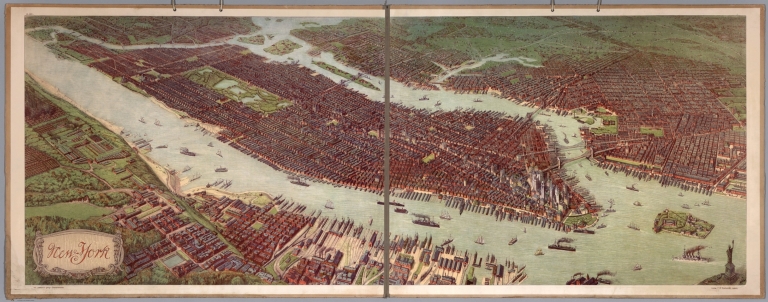
List No
10050.001
Note
Date estimated based on presence of Singer Building of 1908 and absence of MetLife Tower of 1909 (thanks to Piotr Tarczynski for pointing this out to us). Birds-eye view of Manhattan and greater New York. From askArt: "Josef Ferdinand Klemm (Austrian, 1868-1916) was a noted painter, lithographer, designer and image restorer. He is primarily known for his finely detailed designs of cultural and historical mural study-decorations for schools that included landscapes, cityscapes, medieval cities, the Acropolis (Greece), various architectural renderings, memorial and national monuments, interior scenes, historical and cultural human genre/civil activities, as well as educational/industrial cut-away diagrams/wall-charts, geographical scenes, etc. Josef Klemm was born December 25, 1868 in Vienna, Austria to the Austrian bookseller and publisher Joseph Klemm (Austrian, b. Apr. 4, 1821-d. Feb. 27, 1882) and Johanna (née Fessl) Klemm." This copy came from a school in Helsinki, Finland.
Author
Baker, Harriet E.
Full Title
(Title Page to) Harriet E. Baker's Book of Penmanship & Maps. At Mr. Dunham's School Windsor Vermont March 31, 1819.
List No
8307.002
Note
The existence of this book of penmanship throws interesting light on our other book of penmanship by Frances Henshaw, our 2501.000. This book by Harriet Baker is dated four years earlier, 1819, and from another school in Windsor, Vermont (Henshaw's school was in Middlebury, Vermont). Generally, the two books follow very similar structure, both the text and the maps, which would indicate that the production of these books of penmanship was more frequent than previously thought and also suggests that there was a common template used, even by different schools, in their construction. It can be said that Baker's maps are exquisite, perhaps a bit more so than Henshaw's, but Henshaw's text descriptions of the states are more elaborate than Baker's. For some reason, Baker omits maps of New York, Pennsylvania, South Carolina, Kentucky, Indiana, Illinois and Michigan, while including descriptions of most of them. Henshaw has no map or description of Michigan or Illinois. For the sources of the maps and text, see our entry for Henshaw's book, 2501.000. The Osher Map Library has a copy of another book of penmanship, also from Mr. Dunham's School in Windsor Vermont, titled “Catharine M. Cook’s Book of Penmanship at Mr. Dunham’s School, Windsor, Vermont, June 15th, 1818”
Author
Baker, Harriet E.
Full Title
(Description of) New Hampshire. (to accompany) Harriet E. Baker's Book of Penmanship & Map. At Mr. Dunham's School Windsor Vermont March 31, 1819.
List No
8307.019
Note
A short description of the state of New Hampshire. Hand lettered text.
Author
Baker, Harriet E.
Full Title
New Hampshire. (to accompany) Harriet E. Baker's Book of Penmanship & Map. At Mr. Dunham's School Windsor Vermont March 31, 1819.
List No
8307.020
Note
Outline color map by county. Showing cities and towns, and rivers.
Author
Baker, Harriet E.
Full Title
(Description of) Connecticut. (to accompany) Harriet E. Baker's Book of Penmanship & Map. At Mr. Dunham's School Windsor Vermont March 31, 1819.
List No
8307.025
Note
A short description of the state of Connecticut surrounded by vines. Hand lettered text.
Author
Baker, Harriet E.
Full Title
Connecticut. (to accompany) Harriet E. Baker's Book of Penmanship & Map. At Mr. Dunham's School Windsor Vermont March 31, 1819.
List No
8307.026
Note
Outline color map by county. Showing cities and towns, and rivers. Relief shown by hachures.
Author
Baker, Harriet E.
Full Title
(Description of) New Jersey. (to accompany) Harriet E. Baker's Book of Penmanship & Map. At Mr. Dunham's School Windsor Vermont March 31, 1819.
List No
8307.031
Note
A short description of the state of New jersey. Hand lettered text.
Author
Baker, Harriet E.
Full Title
New Jersey. (to accompany) Harriet E. Baker's Book of Penmanship & Map. At Mr. Dunham's School Windsor Vermont March 31, 1819.
List No
8307.032
Note
Outline color map by county, with decorative cartouche. Showing cities and towns, and rivers. Relief shown by hachures.
Author
Rutley, F.
Full Title
Andrews' Schoolroom Chart Of Geographical Illustrations. Thomas Murby, 32, Bouverie Street, Fleet Street, London. Designed by F. Rutley Esq, H.M. Geol. Survey. Drawn by Waldo Sargeant, Printed by W. Griggs. (inset) Map Of Europe Explanatory Of Geographical Terms. (untitled birds eye view illustrating land and water formations). (with 6 additional inset maps and 1 profile).
List No
0867.000
Note
Date is approximate. Maps include: Map Of Europe, untitled birds eye view of land formations, The Earth In Space, The World In Hemispheres, Zones (also showing mountains of the world), The Seasons, Hemispheres Shewing The Proportion Of Land To Water, and Points Of The Compass (showing rivers of the world). Profile is titled "Section Of The Earth's Crust." Full printed color. Map is dissected into 36 sections and is edged and backed with linen. Folds into marbled end sheets into a new rust cloth folding case 24x28 with "Andrews' Chart of Geographical Illustrations F. Rutley 1915" stamped in gold on the spine.
Author
Smiley, Thomas T.
Full Title
(Covers to) Smiley's Atlas, For The Use Of Schools And Families. A New Atlas, Intended To Illustrate The Encyclopedia Of Geography. (On The Plan Of Murray's Encyclopedia Of Geography.) ... Exhibiting The Natural And Political Divisions Of The Different Countries On The Globe. By Thos. T. Smiley, A.M., M.D. Philadelphia. Hogan & Thompson. (1842?), 1839 ... Entered ... 1838, by Thos. T. Smiley ... Pennsylvania.
List No
0902A
Author
Smiley, Thomas T.
Full Title
Atlantic Ocean.
List No
0902.001
Note
In full color. The map of the Atlantic Ocean includes a vignette of the landing of Columbus.
Author
Smiley, Thomas T.
Full Title
World Globular Projection.
List No
0902.002
Note
In full color. The World projections are surrounded by two sets of projections - one showing the hemispheres and a northern and southern polar projection. Four other insets explain circles, zones, parallels, and meridians. Vignette depicting two children representing history and science, with a sheath of wheat representing agriculture.
Author
Smiley, Thomas T.
Full Title
N. America. Engraved by E.F. Woodward.
List No
0902.003
Note
In full color by country. Black and white vignette of an Indian at Lough Water Gap.
Author
Smiley, Thomas T.
Full Title
United States. (with) Eastern States.
List No
0902.004
Note
In full color by state or territory. Two inset vignettes: the signing of the Declaration of Independence and depictions of "commerce, manufacture and agriculture."
Author
Smiley, Thomas T.
Full Title
Middle States.
List No
0902.005
Note
In full color by state. Uncolored vignette depicts the signing of Penn's Treaty.
Author
Smiley, Thomas T.
Full Title
Southern States. (with) South Part of Florida.
List No
0902.006
Note
In full color by state. Uncolored vignette showing a variety of ships and entitled "Commerce of the Southern States."
Author
Smiley, Thomas T.
Full Title
Western States. (with) inset map of Upper Michigan.
List No
0902.007
Note
In full color by state. Vignette of an Indian hunter.
Author
Smiley, Thomas T.
Full Title
South America. Engraved by E.F. Woodward.
List No
0902.008
Note
In full color by country. South American vignette of a native Peruvian.
Author
Smiley, Thomas T.
Full Title
Europe. Engraved by E.F. Woodward.
List No
0902.009
Note
In full color by country. European vignette shows three women representing the arts, agriculture, commerce and science.
Author
Smiley, Thomas T.
Full Title
Asia. Engraved by E.F. Woodward.
List No
0902.010
Note
In full color by country. Vignette of a woman with coffee and tea plants.
Author
Smiley, Thomas T.
Full Title
Africa.
List No
0902.011
Note
In full color by country or region. Vignette on African map depicts "Music & Dancing of the Negroes."
Author
Smiley, Thomas T.
Full Title
Pacific Ocean.
List No
0902.012
Note
In full color by country or region. The Pacific Ocean vignette shows "Whale Fishery in the Pacific."
Author
Burritt, Elijah H.
Full Title
(Covers to) Atlas, Designed To Illustrate The Geography Of The Heavens ... By Elijah H. Burritt, A.M. New Edition. New York: Published By Huntington And Savage 216 Pearl Street. Entered ... 1835, by F.J. Huntington ... Connecticut.
List No
2853A
Author
Burritt, Elijah H.
Full Title
A Plan of the Solar System Exhibiting its Relative Magnitudes and Distances. Plate I. Hartford, Published by F.J. Huntington 1835, Entered according to Act of Congress Sepr. 1st 1835 by F.J. Huntington of the State of Connecticut. Engraved by W.G. Evans N. York, under the Direction of E.H. Burritt.
List No
2853.001
Note
Upper half of the pages shows the relative magnitudes of the planets along with a chart detailing relative diameters of the same. At the bottom left are a number of diagrams showing the comparative distances of the planets to the sun and the distances of the satellites from their planets. At the bottom right is a chart entitled, "Plan of the Solar System Exhibiting the relative Position of the Planets Orbits and their Inclination to the Plane of the Ecliptic." All uncolored.
Author
Burritt, Elijah H.
Full Title
(The constellations in) March, February, January (Pl. III), December, November, and October (Pl. II). Engraved by W.G. Evans N. York, under the Direction of E.H. Burritt. Hartford, Published by F.J. Huntington 1835. Entered according to act of Congress Septr. 1st 1835, by F.J. Huntington, of the State of Connecticut.
List No
2853.002
Note
The pages are numbered in such a way that Plate III precedes Plate II. The constellations are in full color. The stars are different sized depending upon their magnitude. In full color.
Author
Anonymous
Full Title
United States.
List No
5442.000
Note
Outline color hand drawn map by a young student. A silk blue border has been sown onto map with silk hooks for hanging. Date estimated from geography of the west.
Author
Adams, Daniel
Full Title
(Covers to) School atlas to Adams' Geography. Containing the following maps: ... Boston: Published by Lincoln & Edmands, No. 53 Cornhill. Sold by them and by the principal booksellers in the United States, 1819.
List No
0004A
Note
Cover title. With an oval vignette of a "Geographer" and his globe. Fine copy with original dust jacket. Publisher's advertisement on back cover.
Full Title
The World. Published by Lincoln & Edmands, (1819)
List No
0004.001
Note
Uncolored engraved double hemisphere map. Small ancillary maps: Zones -- Circles -- Parallels -- Meridians.
Full Title
North America. Published by Lincoln & Edmands, Boston, (1819)
List No
0004.002
Note
Uncolored engraved map. Relief shown pictorially.
Full Title
United States. (with) New England States. Wightman Sc. Published by Lincoln & Edmands, Boston, (1819)
List No
0004.003
Note
Uncolored engraved map with inset. Relief shown pictorially. Prime meridians: London and Philadelphia.
Full Title
South America. Published by Lincoln & Edmands, Boston, (1819)
List No
0004.004
Note
Uncolored engraved map. Relief shown pictorially.
Full Title
Europe. Published by Lincoln & Edmands, Boston, (1819)
List No
0004.005
Note
Uncolored engraved map. Relief shown pictorially. Engraver name erased from plate.
Full Title
British Isles. (with) Shetland Isles. Withington sculp. (Published by Lincoln & Edmands, 1819)
List No
0004.006
Note
Uncolored engraved map with inset.
Full Title
Asia. (Published by Lincoln & Edmands, 1819)
List No
0004.007
Note
Uncolored engraved map. Relief shown by hachures.
Full Title
Africa. (Published by Lincoln & Edmands, 1819)
List No
0004.008
Note
Uncolored engraved map. Relief shown pictorially.
Author
Adams, Daniel
Full Title
(Covers to) Atlas to Adams' geography. Containing the following maps ... Boston: Published by Lincoln & Edmands, No. 59 Washington Street. Cushing & Sons, and Joseph Jewett, Baltimore. Hubbard & Edmands, Cincinnati. Sold by them and by the principal booksellers in the United States. 1832.
List No
0006A
Note
11 maps by H. Morse, who, according to the Dictionary of American Painters, Sculptures, and Engravers, is Hazen Morse. He worked for Annin and Smith as an engraver. He did many of the school atlases of the period -- Adams, Worcester, Cummings, and Blake. In outline color. With brown covers. Cover title.
Full Title
The World. G. Boynton Sc. Published by Lincoln & Edmands. (1832)
List No
0006.001
Note
Engraved double hemisphere map. Outline hand col. Insets: Comparative view of the principal lakes in the eastern continent -- Comparative view of the principal lakes of the western continent -- Zones -- Circles -- Parallels -- Meridians.
Full Title
North America. H. Morse Sc. Published by Lincoln & Edmands, Boston. (1832)
List No
0006.002
Note
Engraved map. Outline hand col. Relief shown pictorially.
Full Title
United States. H. Morse Sc. Published by Lincoln & Edmands, Boston. (1832)
List No
0006.003
Note
Engraved map. Outline hand col. Relief shown pictorially. Includes inset. Prime meridians: Washington and Greenwich.
Full Title
New England States. Middle States. H. Morse Sc. Published by Lincoln & Edmands, Boston. (1832)
List No
0006.004
Note
Two engraved maps on 1 sheet. Outline hand col. Relief shown pictorially. Prime meridians: Greenwich and Washington.
Full Title
Western States. H. Morse Sc. Published by Lincoln & Edmands, Boston. (1832)
List No
0006.005
Note
Engraved map. Outline hand col. Relief shown pictorially. Covers Missouri, Illinois, Indiana, Ohio, Kentucky and Tennessee.
|


![[Europe.]](https://www.davidrumsey.com/rumsey/Size2/RUMSEY~8~1/213/14489003.jpg)
![[Europe.]](https://www.davidrumsey.com/rumsey/Size2/RUMSEY~8~1/213/14489004.jpg)


![[France.]](https://www.davidrumsey.com/rumsey/Size2/RUMSEY~8~1/213/14489021.jpg)
![[Armorican Massif, France.]](https://www.davidrumsey.com/rumsey/Size2/RUMSEY~8~1/213/14489025.jpg)
![[Loire River.]](https://www.davidrumsey.com/rumsey/Size2/RUMSEY~8~1/213/14489026.jpg)
![[Loire River.]](https://www.davidrumsey.com/rumsey/Size2/RUMSEY~8~1/213/14489027.jpg)


![[North and South America.]](https://www.davidrumsey.com/rumsey/Size2/RUMSEY~8~1/213/14489044.jpg)
![[South America.]](https://www.davidrumsey.com/rumsey/Size2/RUMSEY~8~1/213/14489045.jpg)


![Covers: Mala vlastiveda [The Little Civics Reader]](https://media.davidrumsey.com/MediaManager/srvr?mediafile=/Size3/RUMSEY~8~1/213/15867001.jpg)
![Title: Mala vlastiveda [The Little Civics Reader]](https://media.davidrumsey.com/MediaManager/srvr?mediafile=/Size3/RUMSEY~8~1/213/15867002.jpg)
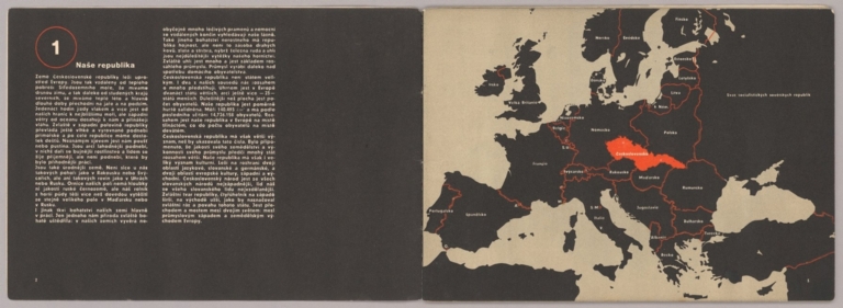
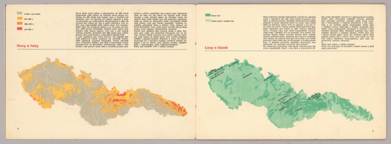
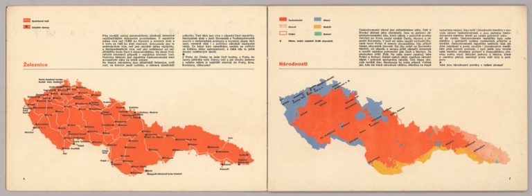
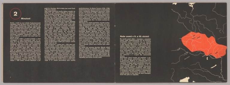

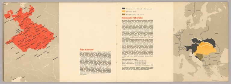
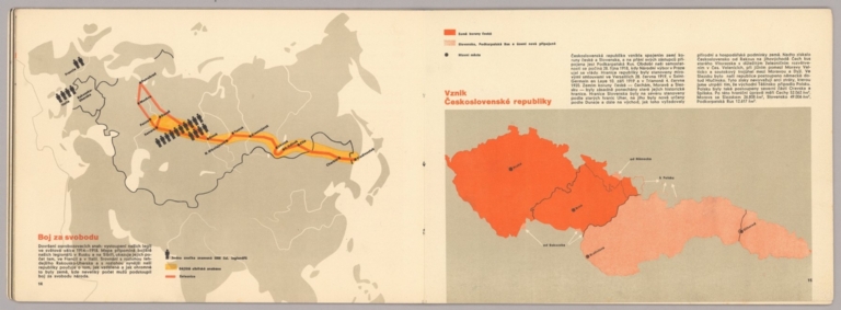
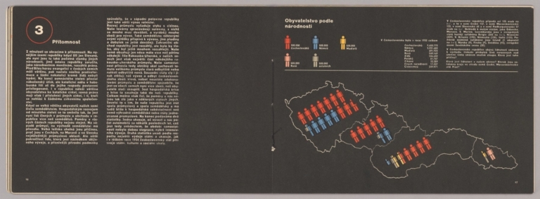
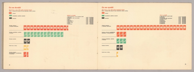
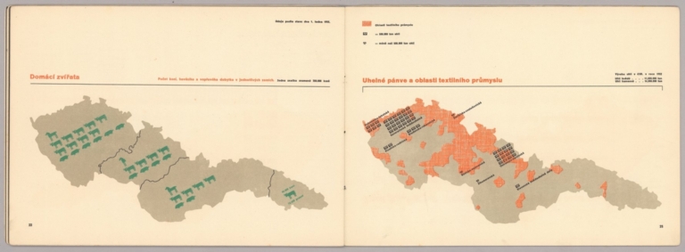
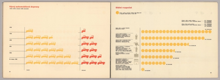
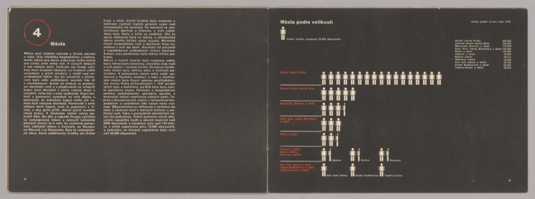
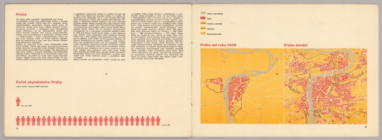
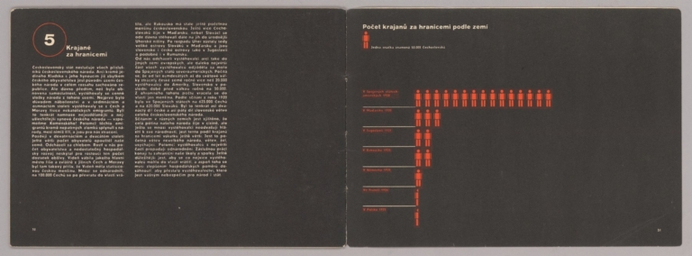
![Covers: [Egyptian/German manuscript schoolgirl atlas].](https://www.davidrumsey.com/rumsey/Size2/RUMSEY~8~1/205/14317001.jpg)


![[Nile River Delta].](https://www.davidrumsey.com/rumsey/Size2/RUMSEY~8~1/205/14317005.jpg)
![[Nile River, to Lake Victoria].](https://www.davidrumsey.com/rumsey/Size2/RUMSEY~8~1/205/14317006.jpg)

![[Watercolor palette].](https://www.davidrumsey.com/rumsey/Size1/RUMSEY~8~1/205/14317008.jpg)


![萬國地誌畧暗射掲圖 / 亜非利加之部 [Topographical Record of the Nations / Africa].](https://www.davidrumsey.com/rumsey/Size2/RUMSEY~8~1/199/15156000.jpg)
![萬國地誌畧暗射掲圖 / 亜細亜之部 [Topographical Record of the Nations / Asia].](https://www.davidrumsey.com/rumsey/Size2/RUMSEY~8~1/199/15157000.jpg)