|
Author
Logerot, A. (Auguste)
Full Title
[Map of Europe.] Ce 8 8bre 1856 ; A. Logerot.
List No
14489.003
Note
Manuscript map representing Europe. Shows select regions, mountain ranges, drainage, coastlines, and islands. Relief shown with hachure lines and shading. Indexed to indicate the names of mountain ranges. Ink, pencil, and watercolor on paper. Indexed to indicate locations such as the Tyrolean Alps and Saint-Gotthard Massif. Map is 24 x 30 cm, on sheet 24 x 32 cm.
Author
Logerot, A. (Auguste)
Full Title
[Map of Europe.] Ce 15 8bre 1856 ; A. Logerot.
List No
14489.004
Note
Manuscript map representing Europe. Shows select regions, cities, mountain ranges, drainage, coastlines, and islands. Relief shown with shading. Features watershed areas, which are differentiated by color. Indexed to indicate the names of mountains and lakes. Ink, pencil, and watercolor on paper. Map is 24 x 30 cm, on sheet 24 x 32 cm.
Author
شكوفه مقبل [Şukufe Mukbil]
Full Title
(Rivers of Europe)
List No
10992.002
Note
Dimensions are sheet size.
Author
شكوفه مقبل [Şukufe Mukbil]
Full Title
(Political map of Europe)
List No
10992.003
Note
Dimensions are sheet size.
Author
Ramzi, Muhammad
Full Title
(Outline map of Europe). Umumi jughrafia atlasi = Atlas of general geography. Assar Muhammad Ramzi, Maktab Harbiye Matbaa si. Mulayiyuh sanah 1328 (1910).
List No
13532.004
Note
Outline map of Europe.
Author
Ramzi, Muhammad
Full Title
(Outline map of Balkan Peninsula). Umumi jughrafia atlasi = Atlas of general geography. Assar Muhammad Ramzi, Maktab Harbiye Matbaa si. Mulayiyuh sanah 1328 (1910).
List No
13532.005
Note
Outline map of Balkan Peninsula. Includes 2 insets. Extend from Romania in the north to Crete Island in south. Shows political boundaries and roads. Some boundaries, countries and cities are marked in with pen.
Author
Ramzi, Muhammad
Full Title
(Outline map of Balkan Peninsula). Umumi jughrafia atlasi = Atlas of general geography. Assar Muhammad Ramzi, Maktab Harbiye Matbaa si. Mulayiyuh sanah 1328 (1910).
List No
13532.006
Note
Outline map of Balkan Peninsula. Includes 2 insets. Extend from Romania in the north to Crete Island in south.
Author
Wells, Edward, 1667-1727
Full Title
A new map of Europe according its Ancient general divisions and names of its countries together with their chief cities rivers mountains & c. Delin. MBurg sculp. Sculp. (to accompany) A new sett of maps both of antient and present geography. 3.
List No
11181.006
Note
Copper engraved double page map. Shows ancient political divisions. Includes abbreviations. Relief shown pictorially.
Author
Wells, Edward, 1667-1727
Full Title
A new map of Europe according to the present general divisions and names of its countries together with their capital cities chief rivers mountains & c. Delin. MBurg sculp. Sculp. (to accompany) A new sett of maps both of antient and present geography. 4.
List No
11181.007
Note
Copper engraved double page map. Shows present political divisions. Includes abbreviations. Relief shown pictorially.
Author
Wells, Edward, 1667-1727
Full Title
A new map of Iberia Europaea alias Celtiberia, or Ancient Spain, shewing its principal divisions, cheif cities, townes, rivers, mountains &c. R. Spofforth sculp. (to accompany) A new sett of maps both of antient and present geography. 5.
List No
11181.008
Note
Copper engraved double page map. Shows ancient administrative divisions. Includes abbreviations. Relief shown pictorially.
Author
Wells, Edward, 1667-1727
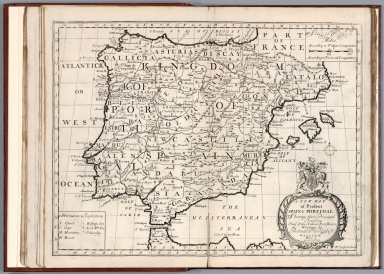
Full Title
A new map of present Spain & Portugal. Shewing their principal divisions, cheif cities, townes, ports, rivers, mountains &c. R. Spofforth sculp. (to accompany) A new sett of maps both of antient and present geography. 6.
List No
11181.009
Note
Copper engraved double page map. Shows present political and administrative divisions. Includes abbreviations. Relief shown pictorially.
Author
Wells, Edward, 1667-1727
Full Title
A new map of ancient Gaul or Gallia Transalpina shewing the divisions thereof by Augustus Caesar together with its principal people cities townes rivers mountains &c. R. Spofforth sculp. (inset) Gallia divided according to Julius Caesar's Commentaries. (to accompany) A new sett of maps both of antient and present geography. 7.
List No
11181.010
Note
Copper engraved double page map with inset. Shows ancient political and administrative divisions. Includes abbreviations. Relief shown pictorially.
Author
Wells, Edward, 1667-1727
Full Title
A new map of France shewing its principal divisions cheif cities, townes, ports, rivers, mountains &c. R. Spofforth sculp. (to accompany) A new sett of maps both of antient and present geography. 8.
List No
11181.011
Note
Copper engraved double page map. Shows administrative divisions. Includes abbreviations. Relief shown pictorially.
Author
Wells, Edward, 1667-1727
Full Title
A new map of Netherlands, or Low Countries, shewing their principal divisions, cities, townes, rivers &c. Sutton Nicholls sculp. (inset) A draught of the sea coasts of Holland and parts adjoining, as they are supposed to have been in antient times. (to accompany) A new sett of maps both of antient and present geography. 9.
List No
11181.012
Note
Copper engraved double page map with inset. Covers the Netherlands, Belgium, Luxemburg, and part of Germany. Shows administrative divisions. Includes abbreviations.
Author
Wells, Edward, 1667-1727
Full Title
A new map of the Brittish Isles shewing their antient people, cities, and towns of note, in the time of the Romans. Sutton Nicholls sculp. (to accompany) A new sett of maps both of antient and present geography. 10
List No
11181.013
Note
Copper engraved double page map. Shows ancient political and administrative divisions. Includes explanations. Relief shown pictorially.
Author
Wells, Edward, 1667-1727
Full Title
A new map of the Brittish Isles shewing their present genl. divisions, cities, and such other towns, or places, as answer to the towns of note in the time of the Romans. Sutton Nicholls sculp. (to accompany) A new sett of maps both of antient and present geography. 11.
List No
11181.014
Note
Copper engraved double page map. Shows present political and administrative divisions. Includes explanations. Relief shown pictorially.
Author
Wells, Edward, 1667-1727
Full Title
A new map of antient Germany, Rhaeia, Vindelicia, and Noricum. Shewing their principal people, tribes, cities, towns, rivers, mountains, &c. Sutton Nicholls sculp. (to accompany) A new sett of maps both of antient and present geography. 12.
List No
11181.015
Note
Copper engraved double page map. Shows ancient political and administrative divisions. Includes explanations. Relief shown pictorially.
Author
Wells, Edward, 1667-1727
Full Title
A new map of Germany, shewing its principal divisions, cities, towns, rivers, mountains, &c. Sutton Nicholls sculp. (to accompany) A new sett of maps both of antient and present geography. 13.
List No
11181.016
Note
Copper engraved double page map. Shows administrative divisions. Includes explanations. Relief shown pictorially.
Author
Wells, Edward, 1667-1727
Full Title
A new map of antient Italy, together with the adjoyning islands of Sicily, Sardinia, and Corsica, shewing their principal divisions, cities, towns, rivers, mountains &c. Sutton Nicholls sculp. (to accompany) A new sett of maps both of antient and present geography. 14.
List No
11181.017
Note
Copper engraved double page map. Shows ancient administrative divisions. Includes abbreviations. Relief shown pictorially.
Author
Wells, Edward, 1667-1727
Full Title
A new map of present Italy, together with the adjoyning islands of Sicily, Sardinia, and Corsica, shewing their principal divisions, cities, towns, rivers, mountains &c. Sutton Nicholls sculp. (to accompany) A new sett of maps both of antient and present geography. 15.
List No
11181.018
Note
Copper engraved double page map. Shows present administrative divisions. Includes explanations. Relief shown pictorially.
Author
Wells, Edward, 1667-1727
Full Title
A new map of Gallia Cisalpina & Graecia Magna : shewing their cheif divisions, people, cities, towns &c. Sutton Nicholls sculp. (to accompany) A new sett of maps both of antient and present geography. 16.
List No
11181.019
Note
2 copper engraved double page maps on 1 sheet. Shows administrative divisions. Includes explanations and compass rose. Relief shown pictorially.
Author
Wells, Edward, 1667-1727
Full Title
A New Map of Latium Etruria and as much of Antient Italy as lay Between Gallia Cisalpina and Graecia Magna, Shewing its Principal Divisions, Cities, Towns, Rivers &c. Sutton Nicholls sculp. (to accompany) A new sett of maps both of antient and present geography. 17.
List No
11181.020
Note
Copper engraved double page map of central Italy. Shows administrative divisions. Includes explanations and compass rose. Relief shown pictorially.
Author
Wells, Edward, 1667-1727
Full Title
A new map of antient Greece, Thrace, Moesia, Illyricum, and the Isles adjoyning. Ed. Smith sculp. (to accompany) A new sett of maps both of antient and present geography. 18.
List No
11181.021
Note
Copper engraved double page map. Shows political and administrative divisions. Relief shown pictorially.
Author
Wells, Edward, 1667-1727
Full Title
A new map of Turky in Europe and parts adjoyning shewing their principal divisions and chiefe cities, towns, rivers, mountains &c. Ed. Smith sculp. (to accompany) A new sett of maps both of antient and present geography. 19.
List No
11181.022
Note
Copper engraved double page map. Shows political and administrative divisions. Relief shown pictorially. Includes abbreviations.
Author
Wells, Edward, 1667-1727
Full Title
A new map of the So. & mid. parts of antient Greece viz. Epirus, Hellas, or Graecia Propria, and Peloponnesus, together with the adjoyning islands. Ed. Smith sculp. (to accompany) A new sett of maps both of antient and present geography. 20.
List No
11181.023
Note
Copper engraved double page map. Shows political and administrative divisions. Relief shown pictorially. Includes explanations.
Author
Wells, Edward, 1667-1727
Full Title
A new map of antient Thrace : as also of the northern parts of old Greece, viz. Macedonia and Thessalia. Sutton Nicholls sculp. (to accompany) A new sett of maps both of antient and present geography. 21.
List No
11181.024
Note
Copper engraved double page map. Shows political and administrative divisions. Relief shown pictorially. Includes explanations and compass rose.
Author
Wells, Edward, 1667-1727
Full Title
A new map of the islands of the Aegaean Sea, together with the island of Crete, and the adjoining isles, Sutton Nicholls sculp. (to accompany) A new sett of maps both of antient and present geography. 22.
List No
11181.025
Note
Copper engraved double page map. Relief shown pictorially. Includes explanations and compass rose.
Author
Wells, Edward, 1667-1727
Full Title
A new map of Sarmatia, Europaea Pannonia and Dacia shewing their principal divisions, people, cities, towns, rivers, mountains &c. Benj. Cole sculp. (inset) A draught of the North Parts of Europe according to the erroneous opinion of some of the Ancients. (to accompany) A new sett of maps both of antient and present geography. 23.
List No
11181.026
Note
Copper engraved double page map. Showing political divisions. Relief shown pictorially. Includes explanations.
Author
Wells, Edward, 1667-1727
Full Title
A new map of present Poland, Hungary, Walachia, Moldavia, Little Tartary &c. shewing their principall divisions, chief cities, towns, rivers &c. B. Cole sculp. (to accompany) A new sett of maps both of antient and present geography. 24.
List No
11181.027
Note
Copper engraved double page map. Showing political divisions. Relief shown pictorially. Includes explanations.
Author
Wells, Edward, 1667-1727
Full Title
A new map of ancient Scandinavia together with as much more of ye northern part of ancient Europe as answers to present Denmark & Moscovia. (inset) Present Denmark with the adjoining parts of Sweden and Germany. (to accompany) A new sett of maps both of antient and present geography. 25.
List No
11181.028
Note
Copper engraved double page map. Showing political divisions. Relief shown pictorially. Includes abbreviations.
Author
Wells, Edward, 1667-1727
Full Title
A new map of Denmark, Norway, Sweden & Moscovy, shewing their present general divisions, cheif cities or towns, rivers, mountains &c. J. Moxon sculp. (to accompany) A new sett of maps both of antient and present geography. 26.
List No
11181.029
Note
Copper engraved double page map. Showing political divisions. Relief shown pictorially. Includes abbreviations.
Author
Euler, Leonhard, 1707-1783
Full Title
Tab. Geogr. Europae ad emendatiora quoe ad huc prodierunt exempla jussu Acad. Reg Scient eceleg. Litt. Pruss descripta. (to accompany) Atlas geographicus omnes orbis terrarum regiones = Atlas geographique representant en XLI cartes toutes les regions de la terre ... Berolini : Ex officina Michaelis MDCCLIII (1753).
List No
11392.015
Note
Hand colored copperplate engraving map on 2 sheets. Showing mountains, rivers, lakes, geographical and coastal features, political boundaries, cities, and principal towns. Relief shown pictorially. In lower right corner: 11. Europa.
Author
[Euler, Leonhard, 1707-1783, Sauerbrey, Nicolaus Friedrich]
Full Title
Tabula Geographica Europae ad emendatiora exempla adhuc edita jussu Acad. Reg. scient. et litt. eleg. Boruss descripta. (to accompany) Atlas geographicus omnes orbis terrarum regiones = Atlas geographique representant en XLI cartes toutes les regions de la terre ... Berolini : Ex officina Michaelis MDCCLIII (1753).
List No
11392.016
Note
1 map on 4 sheets. In lower right corner: 12. Europa. Hand colored copperplate engraving map on 2 sheets. Covers Northern Europe, Norway, most of Great Britain, Ireland, Iceland, and a long stretch of Greenland's eastern coast. Showing mountains, rivers, lakes, geographical and coastal features, political boundaries, cities, and principal towns. Relief shown pictorially. Prime meridian is Ferro.
Author
[Euler, Leonhard, 1707-1783, Sauerbrey, Nicolaus Friedrich]
Full Title
Tabula Geographica Europae ad emendatiora exempla adhuc edita jussu Acad. Reg. scient. et litt. eleg. Boruss descripta. Sauerbrey sculp. (to accompany) Atlas geographicus omnes orbis terrarum regiones = Atlas geographique representant en XLI cartes toutes les regions de la terre ... Berolini : Ex officina Michaelis MDCCLIII (1753).
List No
11392.017
Note
1 map on 4 sheets. In lower right corner: 13. Europa. Hand colored copperplate engraving map on 2 sheets. Covers Northern Europe. Showing mountains, rivers, lakes, geographical and coastal features, political boundaries, cities, and principal towns. Relief shown pictorially. Prime meridian is Ferro.
Author
[Euler, Leonhard, 1707-1783, Sauerbrey, Nicolaus Friedrich]
Full Title
Tabula Geographica Europae ad emendatiora exempla adhuc edita jussu Acad. Reg. scient. et litt. eleg. Boruss descripta. Sauerbrey sculp. (to accompany) Atlas geographicus omnes orbis terrarum regiones = Atlas geographique representant en XLI cartes toutes les regions de la terre ... Berolini : Ex officina Michaelis MDCCLIII (1753).
List No
11392.018
Note
1 map on 4 sheets. In lower right corner: 14. Europa. Hand colored copperplate engraving map on 2 sheets. Covers Western Europe. Showing mountains, rivers, lakes, geographical and coastal features, political boundaries, cities, and principal towns. Relief shown pictorially. Prime meridian is Ferro.
Author
[Euler, Leonhard, 1707-1783, Sauerbrey, Nicolaus Friedrich]
Full Title
Tabula Geographica Europae ad emendatiora exempla adhuc edita jussu Acad. Reg. scient. et litt. eleg. Boruss descripta. Sauerbrey sculp. (to accompany) Atlas geographicus omnes orbis terrarum regiones = Atlas geographique representant en XLI cartes toutes les regions de la terre ... Berolini : Ex officina Michaelis MDCCLIII (1753).
List No
11392.019
Note
1 map on 4 sheets. In lower right corner: 15. Europa. Hand colored copperplate engraving map on 2 sheets. Covers Southern Europe. Showing mountains, rivers, lakes, geographical and coastal features, political boundaries, cities, and principal towns. Relief shown pictorially. Prime meridian is Ferro.
Author
[Euler, Leonhard, 1707-1783, Sauerbrey, Nicolaus Friedrich]
Full Title
(Composite to) Tabula Geographica Europae ad emendatiora exempla adhuc edita jussu Acad. Reg. scient. et litt. eleg. Boruss descripta. Sauerbrey sculp. (to accompany) Atlas geographicus omnes orbis terrarum regiones = Atlas geographique representant en XLI cartes toutes les regions de la terre ... Berolini : Ex officina Michaelis MDCCLIII (1753).
List No
11392.020
Note
Composite to sheet 12-15 Europa. Hand colored copperplate engraving map on 2 sheets. Covers Eastern Europe to Asia. Showing mountains, rivers, lakes, geographical and coastal features, political boundaries, cities, and principal towns. Relief shown pictorially. Prime meridian is Ferro.
Author
Euler, Leonhard, 1707-1783
Full Title
Tab. Geogr. Hispaniae ad emendatiora exempla adhuc edita jussu Acad. Reg. scient. et eleg. litt. Boruss descripta. Sauerbrey sculp. (to accompany) Atlas geographicus omnes orbis terrarum regiones = Atlas geographique representant en XLI cartes toutes les regions de la terre ... Berolini : Ex officina Michaelis MDCCLIII (1753).
List No
11392.021
Note
Hand colored copperplate engraving map on 2 sheets. Showing mountains, rivers, lakes, geographical and coastal features, political boundaries, cities, and principal towns. Relief shown pictorially. In lower right corner: 38 Spanien u. Portugal.
Author
[Euler, Leonhard, 1707-1783, Claussen, I.C. G.]
Full Title
Tabula geogr: Galliae ad emendatiora que adhuc prodierunt exemple jussu quae adhuc edita jussu Acad. Reg. scient. et eleg. litt. Boruss descripta. I.C.G. Claussen del. (to accompany) Atlas geographicus omnes orbis terrarum regiones = Atlas geographique representant en XLI cartes toutes les regions de la terre ... Berolini : Ex officina Michaelis MDCCLIII (1753).
List No
11392.022
Note
Hand colored copperplate engraving map on 2 sheets. Showing mountains, rivers, lakes, geographical and coastal features, administrative boundaries, cities, and principal towns. Relief shown pictorially. In lower right corner: 17. Franckreich.
Author
[Euler, Leonhard, 1707-1783, Sauerbrey, Nicolaus Friedrich]
Full Title
Tabula geographica Italiae ad emendatiora exampla adhuc edita jussu Acad. Reg. scient. et eleg. litt. Boruss descripta. N.F. Sauerbrey sculpsit Berolin. (to accompany) Atlas geographicus omnes orbis terrarum regiones = Atlas geographique representant en XLI cartes toutes les regions de la terre ... Berolini : Ex officina Michaelis MDCCLIII (1753).
List No
11392.023
Note
Hand colored copperplate engraving map on 2 sheets. Showing mountains, rivers, lakes, geographical and coastal features, administrative boundaries, cities, and principal towns. Relief shown pictorially. In lower right corner: 26 Italien.
Author
Euler, Leonhard, 1707-1783
Full Title
Tabula geograph: Britanniae ad emendatiora exampla adhuc edita jussu Acad. Reg. scient. et eleg. litt. Prussiae descripta. (to accompany) Atlas geographicus omnes orbis terrarum regiones = Atlas geographique representant en XLI cartes toutes les regions de la terre ... Berolini : Ex officina Michaelis MDCCLIII (1753). (inset) Orcades Insvlae.
List No
11392.024
Note
Hand colored copperplate engraving map on 2 sheets. Showing mountains, rivers, lakes, geographical and coastal features, administrative boundaries, cities, and principal towns. Relief shown pictorially. Includes explanation table. In lower right corner: 21 Gross Brittanien.
Author
[Euler, Leonhard, 1707-1783, Sauerbrey, Nicolaus Friedrich]
Full Title
Tabula geographica Angliae et Walliae ad emendatiora exampla adhuc edita jussu Acad. Reg. scient. et eleg. litt. Boruss descripta. Sauerbrey sculp. (to accompany) Atlas geographicus omnes orbis terrarum regiones = Atlas geographique representant en XLI cartes toutes les regions de la terre ... Berolini : Ex officina Michaelis MDCCLIII (1753). (inset) Orcades Insvlae.
List No
11392.025
Note
Hand colored copperplate engraving map on 2 sheets. Showing mountains, rivers, lakes, geographical and coastal features, administrative boundaries, cities, and principal towns. Relief shown pictorially. In lower right corner: 10. Engeland 1 Theil.
Author
Euler, Leonhard, 1707-1783
Full Title
Tabvla geographca Scotia ad emendatiora que adhuc prodierunt exampla jussu ACAD. Reg. Scient. et eleg. litter: descripta. (to accompany) Atlas geographicus omnes orbis terrarum regiones = Atlas geographique representant en XLI cartes toutes les regions de la terre ... Berolini : Ex officina Michaelis MDCCLIII (1753). (inset) Great Britain.
List No
11392.026
Note
Hand colored copperplate engraving map on 2 sheets. Showing mountains, rivers, lakes, geographical and coastal features, administrative boundaries, cities, and principal towns. Relief shown pictorially. In lower right corner: 35. Schottland. 1 T.
Author
Euler, Leonhard, 1707-1783
Full Title
Mappa geographica Regni Hiberniae ad emendatiora que adhuc prodierunt exampla jussu ACAD. Reg. Scient. et eleg. litter: descripta. (to accompany) Atlas geographicus omnes orbis terrarum regiones = Atlas geographique representant en XLI cartes toutes les regions de la terre ... Berolini : Ex officina Michaelis MDCCLIII (1753). (inset) Great Britain.
List No
11392.027
Note
Hand colored copperplate engraving map on 2 sheets. Showing mountains, rivers, lakes, geographical and coastal features, administrative boundaries, cities, and principal towns. Relief shown pictorially. In lower right corner: 25. Irrland. 1 T.
Author
Euler, Leonhard, 1707-1783
Full Title
Tabula geogr: Belgii Universi VII Provinc ad emendatiora exampla adhuc jussu Acad. Reg. Scient. et Eleg. litter. Boruss: descripta. (to accompany) Atlas geographicus omnes orbis terrarum regiones = Atlas geographique representant en XLI cartes toutes les regions de la terre ... Berolini : Ex officina Michaelis MDCCLIII (1753).
List No
11392.028
Note
Hand colored copperplate engraving map on 2 sheets. Showing administrative boundaries, mountains, rivers, lakes, geographical and coastal features, cities, and principal towns. Relief shown pictorially. Includes explanation table. Prime meridian is Ferro. In lower right corner: 29. Niederlande.
Author
Euler, Leonhard, 1707-1783
Full Title
Tab. Geo. Imperia Rom. Germanicia ad emendatiora adhuc edita exempla jussu Acad. Reg. Scient. et eleg. Litter Borussiae descript. (to accompany) Atlas geographicus omnes orbis terrarum regiones = Atlas geographique representant en XLI cartes toutes les regions de la terre ... Berolini : Ex officina Michaelis MDCCLIII (1753).
List No
11392.029
Note
Hand colored copperplate engraving map on 2 sheets. Showing administrative boundaries, mountains, rivers, lakes, geographical and coastal features, cities, and principal towns. Relief shown pictorially. In lower right corner: 39. Teutschland.
Author
Euler, Leonhard, 1707-1783
Full Title
Mappa geograph. circuli Westphalici, Rhenani superioris, Belgii Foederati et catholici ad emendatoria exemplaria adhuc edita jussu Acad. Reg. Scient. et Eleg. Litt. descript. (to accompany) Atlas geographicus omnes orbis terrarum regiones = Atlas geographique representant en XLI cartes toutes les regions de la terre ... Berolini : Ex officina Michaelis MDCCLIII (1753).
List No
11392.030
Note
Hand colored copperplate engraving map on 2 sheets. Showing administrative boundaries, mountains, rivers, lakes, geographical and coastal features, cities, and principal towns. Relief shown pictorially. In lower right corner: 24. Holland, Niederlandwe, Westphalen, Hessen.
Author
Euler, Leonhard, 1707-1783
Full Title
Tabula Geographica Circ. Saxoniae Superioris et Inferioris : Ad Emendatiora Exemplaria Adhuc Edita jussu Acad. Reg. Scient. Et Eleg. Litt. Descripta. (to accompany) Atlas geographicus omnes orbis terrarum regiones = Atlas geographique representant en XLI cartes toutes les regions de la terre ... Berolini : Ex officina Michaelis MDCCLIII (1753).
List No
11392.031
Note
Hand colored copperplate engraving map on 2 sheets. Showing administrative boundaries, mountains, rivers, lakes, geographical and coastal features, cities, and principal towns. Relief shown pictorially. In lower right corner: 34. Ober und Nieder Sachsen.
Author
Euler, Leonhard, 1707-1783
Full Title
Mappa geographica Sveviae, Helvetiae, Lotharingiae, et adjacentium Regionum ad emendatiora exempla adhuc edita jussu Reg. Acad. Scient. et Eleg. Litter. descripta. (to accompany) Atlas geographicus omnes orbis terrarum regiones = Atlas geographique representant en XLI cartes toutes les regions de la terre ... Berolini : Ex officina Michaelis MDCCLIII (1753).
List No
11392.032
Note
Hand colored copperplate engraving map on 2 sheets. Showing Political and administrative boundaries, mountains, rivers, lakes, geographical and coastal features, cities, and principal towns. Relief shown pictorially. In lower right corner: 36. Schwaben, Schweitz, Lothringen.
Author
Euler, Leonhard, 1707-1783
Full Title
Tabula geographica circulorum Austriaci et Bavarici imperii Romano-Germanici : ad emendatiora exempla adhuc edita jussu Academiae Regiae Scientiarum et eleg. Litt. Borussicae descripta. (to accompany) Atlas geographicus omnes orbis terrarum regiones = Atlas geographique representant en XLI cartes toutes les regions de la terre ... Berolini : Ex officina Michaelis MDCCLIII (1753).
List No
11392.034
Note
Hand colored copperplate engraving map on 2 sheets. Covers Austria and Bavaria. Showing Political and administrative boundaries, mountains, rivers, lakes, forests, cities, and principal towns. Relief shown pictorially. In lower right corner: 30. Oesterreich- und Bayerischer Creis.
|
![[Europe.]](https://www.davidrumsey.com/rumsey/Size2/RUMSEY~8~1/213/14489003.jpg)
![[Europe.]](https://www.davidrumsey.com/rumsey/Size2/RUMSEY~8~1/213/14489004.jpg)