|
Author
[Ravenstein, August, Berlin Geographisch-Artistische Anstalt Ernst Schotte]
Full Title
Karten-Ideal zur elementaren Darstellung der topischen Verhältnisse von Wasser und Land auf dem Erdboden, nebst der Oestl. & Westl. Erdhälfte, zur Erläuterung mathemat. eintheilung u. physisch-geograph. Verhältnisse. Zeichnung u. Modell von August Ravenstein in Frankfurt a. M. Stich, Prägung, Druck u. Verlag von B. Dondorf in Frankfurt a. M.
List No
14473.003
Note
Relief map of the world, shown as the Western and Eastern Hemispheres, as well as a closer view of the Netherlands and vicinity. Shows geographical regions, topography, vegetation, bodies of water, drainage, coastlines, shoals and islands. Topography shown with raised relief. Includes latitudinal and longitudinal lines, as well as descriptive notes. Legend for map appears on title page. Colored lithograph. Map is 22 x 27 cm, within frame 24 x 28 cm. Within a series of eight maps comprising the school atlas, Plastischer Schul-Atlas.
Author
[Ravenstein, August, Berlin Geographisch-Artistische Anstalt Ernst Schotte]
Full Title
Deutschland nebst den Königreichen Holland, Belgien und der Republik Schweiz. Zeichnung u. Modell von August Ravenstein in Frankfurt a. M. Stich, Prägung, Druck u. Verlag von B. Dondorf in Frankfurt a. M.
List No
14473.004
Note
Relief map of Germany, the Netherlands, Belgium and Switzerland. Shows geographical regions, countries, cities, railways, canals, topography, vegetation, bodies of water, drainage, coastlines, shoals and islands. Topography shown with raised relief. Includes a legend, bar scale given in miles, latitudinal and longitudinal lines, as well as statistical and descriptive notes. Additional legend for map appears on title page. Colored lithograph. Map is 22 x 27 cm, within frame 24 x 28 cm. Within a series of eight maps comprising the school atlas, Plastischer Schul-Atlas.
Author
Hossein
Full Title
(Political map of the Northwestern Europe). جغرافیای عمومی اطلسی = Atlas of general geography. Istanbul 1300 (1923).
List No
13686.005
Note
Color political map of Netherlands, Belgium and Luxembourg.
Author
شكوفه مقبل [Şukufe Mukbil]
Full Title
(Benelux)
List No
10992.019
Note
Dimensions are sheet size.
Author
Arrowsmith, Aaron Jr.
Full Title
France and the Netherlands, with part of Switzerland. Gallia, Vel Regiones intra Oceanum, Rhenum fl. Alps, Mare Medium et Pyrenaeos sitae. London, Published Jany. 2, 1828 by A. Arrowsmith Hydrographer to His Majesty, No. 10, Soho Square.
List No
0035.013
Note
Two Outline hand color maps. Shows fine detail in naming the major cities, mountain ranges, lakes, and rivers. Includes numbered list of departments. Relief shown by hachures. prime meridian is Greenwich.
Author
[Diercke, Carl, Gaebler, Eduard]
Full Title
Niederlande und Belgien. (to accompany) Diercke Schul-Atlas fur hohere Lehranstalten. (with insets). "30" on the lower right margin.
List No
0243.075
Note
Color map with 6 insets on 2 pages. Relief shown by hachures. Prime meridian is Greenwich.
Author
Duval, Henri
Full Title
Atlas Universel. Tableau historique et geographique des Royaumes de Belgique et de Hollande. ... Par Henri Duval, Chevalier de la Legion d'honneur, Professeur d'histoire, de geographie, de belles-lettres, &. Paris (1834), Chez l'Auteur, rue de la Chaussee d'Antin, No.15... Johanneau, Rue du Coq. No. 8 bis. ,,, Ate. Foucher.
List No
0254.011
Note
Map of Belgium and the Netherlands with chronologies of historic events. Timelines include reigns of French kings for comparative reference. Hand tinted text to match mapped areas.
Author
Lattre, Jean
Full Title
Les Pays Bas Septentrionaux et Meridionaux. A Paris, chez Lattre, avec priv. (ca. 1800)
List No
0421.007
Note
Engraved map. Outline hand coloring. Relief shown pictorially. Prime meridian: Ferro.
Author
[Grenet, Abbe, Bonne, Rigobert]
Full Title
Carte des Sept Provinces-Unies des Pays-Bas, Connues sous le Nom General de Hollande. Avec les Provinces Autrichiennes Situees dans le Meme Pays. Par M. Bonne Ingenieur Hydrographe de la Marine. A' Venise Par P. Santini 1789.(to accompany) Atlas portatif a l'usage des colleges, pour servir a l'intelligence des auteurs classiques. 25.
List No
11172.028
Note
Copper engraved outline hand colored. Detailed map of the Low Countries shows the area from the islands off the coast of Friesland and Embden in the north to Luxembourg in the south. The seventeen provinces are named, as are several rivers and towns, including major cities such as Amsterdam, Rotterdam, the Hague, Bruges, Brussels and Luxembourg. Prime meridians are Paris and Ferro. Relief shown pictorially.
Author
Wells, Edward, 1667-1727
Full Title
A new map of Netherlands, or Low Countries, shewing their principal divisions, cities, townes, rivers &c. Sutton Nicholls sculp. (inset) A draught of the sea coasts of Holland and parts adjoining, as they are supposed to have been in antient times. (to accompany) A new sett of maps both of antient and present geography. 9.
List No
11181.012
Note
Copper engraved double page map with inset. Covers the Netherlands, Belgium, Luxemburg, and part of Germany. Shows administrative divisions. Includes abbreviations.
Author
Euler, Leonhard, 1707-1783
Full Title
Tabula geogr: Belgii Universi VII Provinc ad emendatiora exampla adhuc jussu Acad. Reg. Scient. et Eleg. litter. Boruss: descripta. (to accompany) Atlas geographicus omnes orbis terrarum regiones = Atlas geographique representant en XLI cartes toutes les regions de la terre ... Berolini : Ex officina Michaelis MDCCLIII (1753).
List No
11392.028
Note
Hand colored copperplate engraving map on 2 sheets. Showing administrative boundaries, mountains, rivers, lakes, geographical and coastal features, cities, and principal towns. Relief shown pictorially. Includes explanation table. Prime meridian is Ferro. In lower right corner: 29. Niederlande.
Author
Euler, Leonhard, 1707-1783
Full Title
Mappa geograph. circuli Westphalici, Rhenani superioris, Belgii Foederati et catholici ad emendatoria exemplaria adhuc edita jussu Acad. Reg. Scient. et Eleg. Litt. descript. (to accompany) Atlas geographicus omnes orbis terrarum regiones = Atlas geographique representant en XLI cartes toutes les regions de la terre ... Berolini : Ex officina Michaelis MDCCLIII (1753).
List No
11392.030
Note
Hand colored copperplate engraving map on 2 sheets. Showing administrative boundaries, mountains, rivers, lakes, geographical and coastal features, cities, and principal towns. Relief shown pictorially. In lower right corner: 24. Holland, Niederlandwe, Westphalen, Hessen.
Author
[Meissas, Achille, 1799-187, Michelot, Auguste Jean Charles, 1792-1854]
Full Title
Iles Britanniques, Hollande et Belgique : Par MM. Achille Meissas et Auguste Michelot. 1854. A la Librairie de L. Hachette. Charle, del. Grave sur acier par Dumortier, Ecrit par P.Rousset. (to accompany) Petit atlas universel de geographie Ancienne du Moyen Age et Moderne et de geographie sacree. (inset) Iles Shetland.
List No
11740.022
Note
Colored in outline double page steel engraving map. Showing political divisions, capitals, major cities, landmarks, roads, railroads, rivers, canals and mountains. Relief shown pictorially and by hachures. Includes legend.
Author
Palairet, Jean
Full Title
Ie. Carte des Sept Provinces Unies des Pais Bas &c.
List No
12055.037
Note
Date estimated based on rest of atlas.
Author
Palairet, Jean
Full Title
2e. Carte des Sept Provinces Unies des Pais Bas &c.
List No
12055.038
Note
Date estimated based on rest of atlas.
Author
Homann, Johann Baptist, 1663-1724
Full Title
Imperii Romano-Germanici.
List No
12138.006
Author
Homann, Johann Baptist, 1663-1724
Full Title
Belgii Universi.
List No
12138.018
Author
Homann, Johann Baptist, 1663-1724
Full Title
Septem Provinciae Belgium Foederatum.
List No
12138.020
Author
[Diercke, Carl, 1842-1913, Gaebler, Eduard, 1842-1911]
Full Title
S31. Niederlande und Belgien. Daenemark.
List No
12198.035
Author
[Brion de La Tour, Louis, 1743 – 1803, Desnos, Louis Charles]
Full Title
Les Pays Bas Francois, Autrichiens, et Hollandois, divisee par provinces civiles et ecclesiastiques. A Paris, chez le Sr. Desnos. 1786. A.P.D.R. (to accompany) Atlas general, civil, ecclesiastique et militaire, methodique et elementaire pour l'etude de la geographie et de l'histoire ... par M. Brion, dirige par le sr. Desnos … A Paris 1786.
List No
13129.034
Note
Engraved hand color map of Netherlands. Includes decorative engraved title cartouche and border. Shows administrative boundaries. Relief shown pictorially.
Author
[Brion de La Tour, Louis, 1743 – 1803, Desnos, Louis Charles]
Full Title
Cercles De Westphalie, Haut et Bas Rhin ... A Paris, chez le Sr. Desnos. 1786. (to accompany) Atlas general, civil, ecclesiastique et militaire, methodique et elementaire pour l'etude de la geographie et de l'histoire ... par M. Brion, dirige par le sr. Desnos … A Paris 1786.
List No
13129.036
Note
Engraved hand color map of the Upper and Lower Rhine and Westphalia regions of Germany. Includes decorative engraved title cartouche and border. Shows administrative boundaries. Relief shown pictorially.
Author
Faden, William, 1749-1836
Full Title
The Kingdom of the Netherlands 1818. Published by W. Faden. Jany. 1,1819. Palmer sculp. (to accompany) Atlas minimus universalis, or, A geographical abridgement ancient and modern of the several parts of the earth ... Second edition. Jan 1, 1821.
List No
13243.041
Note
Double page outline hand color copperplate engraved map, Shows administrative boundaries. Prime meridian is Greenwich. Includes reference to administrative divisions.
Author
Stieler, Adolf
Full Title
Deutschland, Niederlande und Schweiz. (to accompany) Atlas ofver alla verldens delar. Upsala, Palmblad & Co. 1825.
List No
13428.016
Note
Engraved hand colored in outline map. Shows administrative and political boundaries.
Author
Stieler, Adolf
Full Title
Nordwestl. Deutschland und Niederlande. (to accompany) Atlas ofver alla verldens delar. Upsala, Palmblad & Co. 1825.
List No
13428.017
Note
Engraved hand colored in outline map of the Netherlands and northwest of Germany. Shows administrative and political boundaries. Includes lists of provinces.
Author
Stieler, Adolf
Full Title
(Composite Map) Deutschland, Netherlande und Schweiz. (to accompany) Atlas ofver alla verldens delar. Upsala, Palmblad & Co. 1825.
List No
13428.021
Note
Composite map: sheets XI-XIV, Germany, Netherlands and Switzerland.
Author
Silishchensky, Mitrofan Ivanovich 1878 - 1944
Full Title
Germaniya i Gollandiya. Ekonomicheskiya karta. Prof. M. I. Silishchenskiy. Gos. Kartogr. Institut NTU-VSNKH-SSR. Kartografiya Leningrad. (to accompany) Geograficheskiy atlas Chast 1.
List No
13461.039
Note
Economic map of Germany and Netherlands. Includes legend and tables.
Author
Silishchensky, Mitrofan Ivanovich 1878 - 1944
Full Title
Italiya i Shveytsariya : Ekonomicheskiya i politicheskaia karta. Pol'sha, Estoniya, Latviya, Litva : Ekonomicheskiya i politicheskaia karta. Prof. M. I. Silishchenskiy. Tipo- -Lit. V.T.U. im. Tov. Dunaeva, Moskva. (to accompany) Geograficheskiy atlas Chast 1.
List No
13461.040
Note
Political and economic map of Italy, Switzerland and Poland, Estonia, Latvia, Lithuania. Includes legend and tables.
Author
Ramzi, Muhammad
Full Title
(Outline map of Germany). Umumi jughrafia atlasi = Atlas of general geography. Assar Muhammad Ramzi, Maktab Harbiye Matbaa si. Mulayiyuh sanah 1328 (1910).
List No
13532.018
Note
Outline map German, Belgium and Netherlands.
Author
Ramzi, Muhammad
Full Title
(Outline map of Germany). Umumi jughrafia atlasi = Atlas of general geography. Assar Muhammad Ramzi, Maktab Harbiye Matbaa si. Mulayiyuh sanah 1328 (1910).
List No
13532.019
Note
Outline map of German, Belgium and Netherlands. Copy 2.
Author
Anestis Konstantinidis, 1846-190
Full Title
Ollandia kai Belgion. Anésti konstantinidis Ekdotie (to accompany) Neótatos geografikos atlas. En Athēnais 1895.
List No
13551.011
Note
Map of Netherlands and Belgium, with inset plans of Amsterdam and Brussels.
Author
Weiland, C. F. (Carl Ferdinand), 1782-1847
Full Title
Das Kœnigreich der Niederlande entworfen von C. F. Weiland. Weimar, im Verlag des Geograph. Instituts, 1825.
List No
14365.038
Note
Map of the Netherlands, as of 1825. Shows political boundaries, cities, forts, population, railways, topography, bodies of water, drainage, coastlines and islands. Relief shown with hachures. Includes latitudinal and longitudinal lines, as well as a legend and two bar scales. Hand-colored engraving. Map is 36 x 27 cm, on sheet 57 x 45 cm. (Plate number taken from table of contents.)
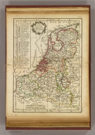
Author
Imhof, Eduard, 1895-1986
Full Title
[Übersichtskarte].
List No
14401.038
Note
Overview map of the Netherlands and Belgium, in 1969. Shows cities, railways, roads, topography, valleys, bodies of water, drainage, coastline, islands and water depths. Relief shown with shading and spot heights. Includes latitudinal and longitudinal lines, a legend, bar scale and scale statement. Colored lithograph. Map is 29 x 17 cm, on sheet 33 x 22 cm. (Title taken from table of contents.) Appears in section entitled Niederlande und Belgien [= Netherlands and Belgium].
Author
Imhof, Eduard, 1895-1986
Full Title
Bodenarten -- Volksdichte und Sprachen -- Amsterdam und Umgebung.
List No
14401.040
Note
Three maps of the Netherlands and Belgium, featuring soil types, populations and languages, as well as Amsterdam and its vicinity, in 1969. Maps show cities, railways, roads, vegetation, bodies of water, drainage, coastlines and islands. Maps include latitudinal and longitudinal lines, legends, bar scales and scale statements (scales differ). Colored lithograph. Together, maps are 29 x 17 cm, on sheet 33 x 22 cm. Maps appear in section entitled Niederlande und Belgien [= Netherlands and Belgium].
Author
Young, J.
Full Title
The seven United Provinces with the Dutch and Austrian Netherlands. By J. Young Geogr. Published as the Act directs 1st July 1778. (to accompany) A New Atlas Or a Compleat (sic) Set of Maps Representing the different Empires, Kingdoms & States of the Known World Including all the Modern Discoveries, By J. Young, A.M.
List No
2226.013
Note
Engraved hand color double page outline map. Shows administrative boundaries, rivers, lakes and mountains. Relief shown pictorially.
Full Title
Nordwestliches Deutschland, Niederlande und Belgien. (Efter Stielers Hand-Atlas. Stockholm, J.L. Brudin, 1852)
List No
2605.014
Note
Engraved map. Outline hand coloring. Relief shown by hachures. In German. Prime meridian: Ferro.
Author
Monin, C.V.
Full Title
Hollande et Belgique par C.V. Monin. Grave sur Acier par Laguillermie Rue des Noyers, No. 56.
List No
2613.006
Note
Division of states outlined in color. Canals and swamps shown. Prime meridian Paris. Relief shown with hachures.
Author
[Cleobury, Miss., Wilkinson, R.]
Full Title
(Text Page to) United Provinces. (to accompany) Practical Geography; In A Series of Exercises, Illustrative Of The Geography Of All The Countries In The Civilized World ... By Miss Cleobury, Of Nottingham. 1815.
List No
2687.040
Note
Series of geographical inquiries about United Provinces: : including Holland, Frieseland, Groningen, Over-Ysse, Gelders, Utrecht, and Zeeland.
Author
[Cleobury, Miss., Wilkinson, R.]
Full Title
United Provinces. Copied from Wilkinson's General Atlas. (to accompany) Practical Geography; In A Series of Exercises, Illustrative Of The Geography Of All The Countries In The Civilized World ... By Miss Cleobury, Of Nottingham. 1815.
List No
2687.041
Note
Outline color map. Including Holland, Frieseland, Groningen, Over-Ysse, Gelders, Utrecht, and Zeeland. Shows political divisions. Prime meridian is London.
Author
[Cleobury, Miss., Wilkinson, R.]
Full Title
(Text Page to) United Provinces. (to accompany) Practical Geography; In A Series of Exercises, Illustrative Of The Geography Of All The Countries In The Civilized World ... By Miss Cleobury, Of Nottingham. 1815.
List No
2687.042
Note
Series of answers to geographical inquiries about United Provinces: including Holland, Frieseland, Groningen, Over-Ysse, Gelders, Utrecht, and Zeeland.
Author
[Cleobury, Miss., Wilkinson, R.]
Full Title
(Text Page to) Netherlands. (to accompany) Practical Geography; In A Series of Exercises, Illustrative Of The Geography Of All The Countries In The Civilized World ... By Miss Cleobury, Of Nottingham. 1815.
List No
2687.043
Note
Series of geographical inquiries about Netherlands.
Author
[Cleobury, Miss., Wilkinson, R.]
Full Title
Netherlands. Copied from Wilkinson's General Atlas. (to accompany) Practical Geography; In A Series of Exercises, Illustrative Of The Geography Of All The Countries In The Civilized World ... By Miss Cleobury, Of Nottingham. 1815.
List No
2687.044
Note
Outline color map. Shows administrative divisions. Prime meridian is Greenwich.
Author
[Cleobury, Miss., Wilkinson, R.]
Full Title
(Text Page to) Netherlands. (to accompany) Practical Geography; In A Series of Exercises, Illustrative Of The Geography Of All The Countries In The Civilized World ... By Miss Cleobury, Of Nottingham. 1815.
List No
2687.045
Note
Series of answers to geographical inquiries about Netherlands.
Full Title
(Provinces-Unies. A Lyon, Chez Jean-Marie Bruyset, Pere & Fils. M.DCC.LXXXIV)
List No
4122.010
Note
Engraved map. Hand colored. Prime meridian: Ferro.
Author
Clouet, J. B. L. (Jean-Baptiste Louis), b. 1730
Full Title
De la Hollande. (1787)
List No
4757.047
Note
Abbot Jean Baptiste Louis Clouet (c. 1730 – 1790) was a French cartographer active in the mid to late 18th century. Clouet held the post of Royal Geographer of the Academie des Sciences de Rouen, he had offices in Paris and Cadiz. Clouet’s most important work is his Geographie Moderne, which was published in various editions from 1776 – 1793. Clouet also produced a series of stunning and highly decorative wall maps depicting the various continents. He followed in the footsteps of Jean-Baptiste Nolin and other French cartographers, reissuing these grand wall-maps in the latter part of the 18th century to decorate the houses of Paris and more unusually Spain.
Author
Ruhle von Lilienstern, August
Full Title
Frankreich und die Niederlande. Berlin 1824 von R.v.L.
List No
5759.011
Note
Shows hachured relief, hydrography, cities, and countries outlined in color.
Author
Ruhle von Lilienstern, August
Full Title
Konigreich der Niederlande. Berlin 1825 von R.v.L.
List No
5759.012
Note
Shows hachured relief, hydrography, cities, and countries outlined in color.
Author
[Kartographia Winterthur, Conférence Suisse des Directeurs Cantonaux de l'instruction Publique]
Full Title
Iles Britanniques, Belgique, Pays-Bas, Danmark. Kartographia Winterthur S.A. Conference des Chefs des Depart. Cant. de l'Instruction Publique. Atlas Scolaire 2e. Edition.
List No
5967.036
Note
Seven color maps on two pages. Relief shown by hachures and spot heights. Depth shown by isoline and soundings. Development conique rectifie suivant le parallele moyen de 55(degrees).
Author
[Kartographia Winterthur, Conférence Suisse des Directeurs Cantonaux de l'instruction Publique]
Full Title
Belgique et Pays-Bas. 1. Environs de Rotterdam. 1:500,000. Nature du sol. 3. densite de la Population. 1: 4,000,000. 4. Amsterdam et ses environs. 1: 200,000. Danmark. 1. Islande. 1:6,000,000. 2. Far Oer. 1:2,000,000. 3. Nature du sol. 4. Densite de la Population. 1:4,000,000. 5. Copenhague. 1:200,000. Kartographia Winterthur S.A. Conference des Chefs des Depart. Cant. de l'Instruction Publique. Atlas Scolaire 2e. Edition.
List No
5967.037
Note
Nine color maps on two pages. Relief shown by hachures and spot heights. Depth shown by isoline and soundings.
Author
Wagner, Hermann
Full Title
No. 18. Nordwest-Deutschland.
List No
7826.026
Author
Wagner, Hermann
Full Title
No. 30. Die Nordseelander.
List No
7826.040
|


![[Übersichtskarte].](https://www.davidrumsey.com/rumsey/Size2/RUMSEY~8~1/199/14401038.jpg)


