|
REFINE
Browse All : School Atlas and Atlas Map of Pacific
1-25 of 25
Author
Smiley, Thomas T.
Full Title
Pacific Ocean.
List No
0902.012
Note
In full color by country or region. The Pacific Ocean vignette shows "Whale Fishery in the Pacific."
Author
Cornell, S. S. (Sarah S.)
Full Title
Oceania. Designed to accompany Cornell's High school geography. (with) Sandwich Islands. (with) Van Diemens Land and south eastern Australia. Entered ... 1856, by S.S. Cornell ... Southern District of New York. New York: D. Appleton & Co., 443 & 445 Broadway. (1864)
List No
0197.026
Note
Engraved map with 2 insets. Hand colored. Relief shown by hachures. Prime meridians: Greenwich and Washington.
Author
Duval, Henri
Full Title
Atlas Universel. Tableau historique et geographique de l'Oceanie. Par Henri Duval, Chevalier de la Legion d'honneur, Professeur d'Histoire, de Geographie, de Belles-lettres, & &. Paris (1834), Chez l'Auteur, rue de la Chaussee d'Antin, No.15... Johanneau, Rue du Coq. 8 bis. ,,, Impie. lith. de E. Houbloup, rue Dauphine 22 et 24.
List No
0254.029
Note
Map of the Pacific and Australasia with descriptions of historic events and famous personages. Hand tinted text to match regions. Relief shown by simple hachures.
Author
Fitch, George W.
Full Title
Pacific Ocean. Drawn by (to be filled in. By George W. Fitch. New York: Sheldon, Blakeman and Company, 115 Nassau Street. Entered ... 1850, by Huntington and Savage ... New York)
List No
0289.014
Note
Printed map form with title, grid lines and numbers or "mapping plate." The mapping has not been added. Prime meridians: Washington and Greenwich.
Author
Mitchell, Samuel Augustus
Full Title
Map of Oceanica. Entered ... 1839, by S. Augustus Mitchell ... Pennsylvania.
List No
0522.007
Note
Without color. Dotted divisions between countries or regions.
Author
Mitchell, Samuel Augustus
Full Title
Map of Oceanica. Engraved to Illustrate Mitchell's School and Family Geography. No. 16. Engraved by J.H. Young. Entered ... 1839, by S. Augustus Mitchell ... Connecticut.
List No
0523.012
Note
In full color by country or region. Includes historical information about island discoveries.
Author
Vuillemin, A.
Full Title
Nouvelle Carte Elementaire de L'Oceanie a l'Usage des Ecoles Primaires.
List No
12051.019
Author
Woodbridge, William C.
Full Title
Oceanica And The Pacific Ocean. Adapted To Woodbridge's Geography. "Note: For Cities of Malaysia, see Map of Asia." Entered ... 1843, by W.C. Woodbridge ... Massachusetts. Hartford. Published By Wm. Jas. Hamersley. (to accompany) Modern Atlas, Physical, Political And Statistical; Exhibiting On Separate Maps ...
List No
1229.024
Note
Covers are heavy brown paper printed with "School Atlas, To Accompany The Modern School Geography, By William C. Woodbridge ... Hartford: Published By Belknap & Hamersley. Entered ... 1843, by William C. Woodbridge ... Massachusetts. Case, Tiffany & Co. Printers, Hartford, Conn." The source of scale is the Political map of Asia. Relief shown by hachures.
Author
Faden, William, 1749-1836
Full Title
New Holland, with the adjacent Polynesia. Published by W. Faden. Jany. 1,1819. W. Palmer, Sc. (to accompany) Atlas minimus universalis, or, A geographical abridgement ancient and modern of the several parts of the earth ... Second edition. Jan 1, 1821.
List No
13243.065
Note
Double page outline hand color copperplate engraved map. Map 48 bound before map 47. Prime meridian is London. Relief shown pictorially. Includes manuscript log in right margin.
Author
Faden, William, 1749-1836
Full Title
Nea-Polynesia or the Islands newly discover’d in the Pacific Ocean. Published by Wm. Faden. Jany. 1,1819. W. Palmer, Sculp. (to accompany) Atlas minimus universalis, or, A geographical abridgement ancient and modern of the several parts of the earth ... Second edition. Jan 1, 1821.
List No
13243.075
Note
Double page outline hand color copperplate engraved map. Shows expedition tracks of the Captain James Cook and Perouse in Pacific Ocean. Prime meridian is London. Relief shown pictorially.
Author
Meḥmed Remzi
Full Title
(Outline map of Oceania). Umumi jughrafia atlasi = Atlas of general geography. Assar Muhammad Ramzi, Maktab Harbiye Matbaa si. Mulayiyuh sanah 1325 (1907).
List No
13534.023
Note
Outline map of Pacific, with 4 insets, including: Australia, New Zealand, Samoa Islands and Fiji Islands.
Author
Meḥmed Remzi
Full Title
(Outline map of Oceania). Umumi jughrafia atlasi = Atlas of general geography. Assar Muhammad Ramzi, Maktab Harbiye Matbaa si. Mulayiyuh sanah 1325 (1907).
List No
13534.024
Note
Outline map of Pacific, with 4 insets, including: Australia, New Zealand, Samoa Islands and Fiji Islands. Copy 2.
Author
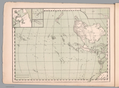
Imhof, Eduard, 1895-1986
Full Title
[Übersichtskarte] -- Hawaii -- Süd-Viktoria-Land -- Saumriff Upolu (Samoa-I.) -- Atoll Funafuti (Ellice-I.) Wallriff Luf (Admiralitäts-I.).
List No
14401.112
Note
Five maps of the Pacific Ocean, featuring an overview map, as well as Hawaii, Victoria Land (Antarctica), Upolu Island (Samoa), Funafuti Atoll (Tuvalu) and the Great Barrier Reef (Australia), in 1969. Maps show cities, topography, volcanos, bodies of water, drainage, coastlines, islands and water depths. Relief shown with shading and spot heights. Maps include latitudinal and longitudinal lines, legends, bar scales and scale statements (scales differ). Colored lithograph. Together, maps are 31 x 39 cm, on double sheet 33 x 44 cm. Maps appear in section entitled Grosser Ozean [= Oceania].
Author
Huntington, Francis Junius, 1802-1878
Full Title
Pacific Ocean, its islands & coasts. Entered ... 12th day of August 1830 by F.J. Huntington ... Connecticut.
List No
1902.011
Note
Engraved map. Hand colored. Relief shown pictorially.
Full Title
Oceanica and comparative N. America & Asia. Entered ... 1836, by Eleazer Huntington ... Connecticut.
List No
2022.016
Note
Engraved map. Hand colored. Relief shown by hachures.
Author
Woodbridge, William C.
Full Title
Pacific Ocean, with a view of Australia and Polynesia, and the Indian Archipelago. By W.C. Woodbridge ... Entered ... 1831, by William C. Woodbridge ... Connecticut. (1837?)
List No
2573.012
Note
Engraved map. Hand colored. Relief shown by hachures.
Full Title
Australien. (Efter Stielers Hand-Atlas. Stockholm, J.L. Brudin, 1852)
List No
2605.008
Note
Engraved map. Outline hand coloring. In German. Prime meridian: Ferro.
Author
Monin, C.V.
Full Title
Oceanie par C.V. Monin. (with) Colonie Anglaise de la Nouvelle Galles du Sud. Grave par Laguillermie, rue des Noyers, No. 56.
List No
2613.020
Note
Divisions outlined in color. Four scales. Prime meridian Paris. Relief shown with hachures.
Author
Mitchell, Samuel Augustus
Full Title
Map of Oceanica. Engraved to illustrate Mitchell's school and family geography. Engraved by J.H. Young. Entered ... 1839 by S. Augustus Mitchell ... Connecticut.
List No
3559.017
Note
Engraved map. Hand colored. Relief shown by hachures. Shows populations, etc. Prime meridians: Greenwich and Washington.
Author
Ruhle von Lilienstern, August
Full Title
Hemisphaere des Stillen Oceans. Berlin 1824 von R.v.L.
List No
5759.004
Note
Shows land masses outlined in color and basic hydrography.
Author
McGraw-Hill Book Company
Full Title
Indian and Pacific Oceans Physical.
List No
6350.037
Note
Shaded relief of ocean bathymetry.
Author
Wagner, Hermann
Full Title
No. 40. Australien und Polynesien.
List No
7826.050
Author
[Gaspari, Adam Christian, Gussefeld, Franz Ludwig]
Full Title
Australien (Australia).
List No
7922.055
Author
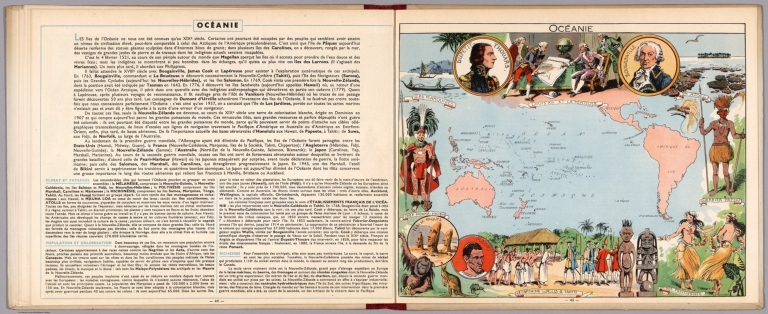
[Pinchon, J.P., Perpillou, A.]
Full Title
(Text Page with Map) Oceanie.
List No
7966.025
Note
Text and corresponding map with lavish vignettes of historic events, activities, crops, modes of transportation, structures, etc.
Author
von Sydow, E.
Full Title
4. Grosser oder Stller Ocean. (Pacific Ocean.)
List No
9028.011
1-25 of 25
|


![[Übersichtskarte] ...](https://www.davidrumsey.com/rumsey/Size2/RUMSEY~8~1/199/14401112.jpg)