|
REFINE
Browse All : School Atlas and Atlas Map of Japan
1-15 of 15
Author
Duval, Henri
Full Title
Atlas Universel. Tableau historique et geographique de L'Asie, Inde, Chine, Japon. Par Henri Duval, Chevalier de la Legion d'honneur, Professeur d'Histoire, de Geographie, de Belles-lettres, & &. Paris (1834), Chez l'Auteur, rue de la Chaussee d'Antin, No.15... Johanneau, Rue du Coq. 8 bis. ,,, Impie. lith. de E. Houbloup, rue Dauphine 22 et 24.
List No
0254.025
Note
Map of far East with descriptions of historic events. Hand tinted text to match regions. Relief shown by simple hachures.
Author
Lattre, Jean
Full Title
L'Empire de la Chine avec les isles du Japon. A Paris, ches Lattre, rue St. Jacq. (ca. 1800)
List No
0421.019
Note
Engraved map. Outline hand coloring. Relief shown pictorially. Prime meridian: Ferro.
Author
شكوفه مقبل [Şukufe Mukbil]
Full Title
(Japan and Korea with railroads)
List No
10992.026
Note
Dimensions are sheet size.
Author
[Grenet, Abbe, Bonne, Rigobert]
Full Title
Empire de la Chine, Rme. de Coree et Isles du Japon. Par M. Bonne, ingr. Hydrographe de la Marine. A' Venise, 1792 Par P. Santini. (to accompany) Atlas portatif a l'usage des colleges, pour servir a l'intelligence des auteurs classiques. 32.
List No
11172.035
Note
Copper engraved outline hand colored. Showing political boundaries, rivers, major cities and towns. Prime meridians are Paris and Ferro. Relief shown pictorially.
Author
Lange, I. E.
Full Title
Charte von Niphon : oder Iapan nebst der von China abhangigen halbsinsel Korea und den Amurlande oder der Mantschurey. (to accompany) Neuer hand und elementar atlas ... Entworfen von I.E. Lange. Leipzig 1809.
List No
11945.016
Note
Engraved and hand painted with outline color map. Shows administrative boundaries, major cities, rivers and mountains. Relief shown by hachures. Includes descriptive text. Prime meridian is Ferro.
Author
Homann, Johann Baptist, 1663-1724
Full Title
Imperii Russici et Tatariae Universae.
List No
12138.033
Author
[Brion de La Tour, Louis, 1743 – 1803, Desnos, Louis Charles]
Full Title
Grande Tartarie Et Isles Du Japon, Suivant les Relations les plus autentiques. Par Mr. Brion. A Paris, chez le Sr. Desnos. 1786. (to accompany) Atlas general, civil, ecclesiastique et militaire, methodique et elementaire pour l'etude de la geographie et de l'histoire ... par M. Brion, dirige par le sr. Desnos … A Paris 1786.
List No
13129.050
Note
Engraved hand color map of Central and north Asia. Includes decorative engraved title cartouche and border. Shows political boundaries. Relief shown pictorially.
Author
Faden, William, 1749-1836
Full Title
China and Chinese Tataria : with Tunquin, Corea, and Japan. Published by W. Faden. Jany. 1,1819. Hatchett, Sc. (to accompany) Atlas minimus universalis, or, A geographical abridgement ancient and modern of the several parts of the earth ... Second edition. Jan 1, 1821.
List No
13243.063
Note
Double page outline hand color copperplate engraved map. Prime meridian is London. Relief shown pictorially. Includes manuscript log in margins.
Author
Silishchensky, Mitrofan Ivanovich 1878 - 1944
Full Title
Yaponiya : Ekonomicheskaia i Politicheskaia karta. Prof. M. I. Silishchenskiy. Gos. Kartogr. Institut NTU-VSNKH-SSR. Kartografiya Leningrad. (to accompany) Geograficheskiy atlas Chast 1.
List No
13461.044
Note
Political and economic map of Japan. Includes legend and tables.
Author
Meḥmed Remzi
Full Title
(Outline map of East Asia). Umumi jughrafia atlasi = Atlas of general geography. Assar Muhammad Ramzi, Maktab Harbiye Matbaa si. Mulayiyuh sanah 1325 (1907).
List No
13534.011
Note
Outline map, shows Japan, North Korea, South Korea, Taiwan and part of Russia and China.
Author
Meḥmed Remzi
Full Title
(Outline map of East Asia). Umumi jughrafia atlasi = Atlas of general geography. Assar Muhammad Ramzi, Maktab Harbiye Matbaa si. Mulayiyuh sanah 1325 (1907).
List No
13534.012
Note
Outline map, Copy 2. Shows Japan, North Korea, South Korea, Taiwan and part of Russia and China.
Author
Clouet, J. B. L. (Jean-Baptiste Louis), b. 1730
Full Title
De l'Empire de la Chine, Re. de Coree, du Japon. (1787)
List No
4757.059
Note
Abbot Jean Baptiste Louis Clouet (c. 1730 – 1790) was a French cartographer active in the mid to late 18th century. Clouet held the post of Royal Geographer of the Academie des Sciences de Rouen, he had offices in Paris and Cadiz. Clouet’s most important work is his Geographie Moderne, which was published in various editions from 1776 – 1793. Clouet also produced a series of stunning and highly decorative wall maps depicting the various continents. He followed in the footsteps of Jean-Baptiste Nolin and other French cartographers, reissuing these grand wall-maps in the latter part of the 18th century to decorate the houses of Paris and more unusually Spain.
Author
[Kartographia Winterthur, Conférence Suisse des Directeurs Cantonaux de l'instruction Publique]
Full Title
Palestine. 1,1000,000. Asie. Chine et Japon. 1:15,000,000. (with inset map) Le Suisse. Kartographia Winterthur S.A. Conference des Chefs des Depart. Cant. de l'Instruction Publique. Atlas Scolaire 2e. Edition.
List No
5967.051
Note
Two color maps on two pages. Relief shown by hachures and spot heights. Depth shown by isolines and soundings. Map of Palestine showing ancient villages, monasteries and ruins.
Author
Wagner, Hermann
Full Title
No. 39. Asiatische Inselwelt.
List No
7826.049
Author
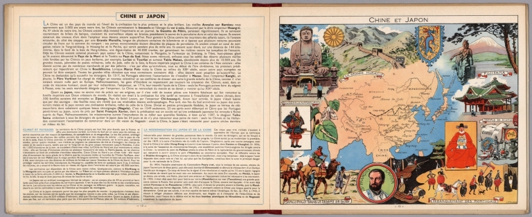
[Pinchon, J.P., Perpillou, A.]
Full Title
(Text Page with Map) Chine et Japon.
List No
7966.009
Note
Text and corresponding map with lavish vignettes of historic events, activities, crops, modes of transportation, structures, etc.
1-15 of 15
|