|
REFINE
Browse All : School Atlas and Atlas Map and School from 1700
1-41 of 41
Author
Wells, Edward, 1667-1727
Full Title
A new map of the terraqueous globe according to the ancient discoveries and most general divisions of it into continents and oceans. Delin. M. Burghers Sculp. Univ. Oxon. (to accompany) A new sett of maps both of antient and present geography. 1.
List No
11181.004
Note
Double hemispherical map of the ancient world with decorative border. Copper engraved double page map. Shows California as an Island, an incomplete New Holland attached to N. Guinea, partial New Zealand Coast line and no Southern Continent. Extensive annotations in North and South America, including a suggestion that the Americas might have been the lost continent of Atlantis, stating: "This Continent with the adjoining islands is generally supposed to have been Anciently unknown though there are not wanting some, who will have even the Continent itself to be no other than the Insula Atlantis of the Ancients." Includes abbreviations.
Author
Wells, Edward, 1667-1727
Full Title
A new map of the terraqueous globe according to the latest discoveries and most general divisions of it into continents and oceans. Delin. M. Burghers Sculp. Univ. Oxon. (to accompany) A new sett of maps both of antient and present geography. 2.
List No
11181.005
Note
Double hemispherical map of the present world with decorative border. Copper engraved double page map. Shows California as an Island, an incomplete New Holland attached to N. Guinea, partial New Zealand Coast line and no Southern Continent. Includes abbreviations.
Author
Wells, Edward, 1667-1727
Full Title
A new map of Europe according its Ancient general divisions and names of its countries together with their chief cities rivers mountains & c. Delin. MBurg sculp. Sculp. (to accompany) A new sett of maps both of antient and present geography. 3.
List No
11181.006
Note
Copper engraved double page map. Shows ancient political divisions. Includes abbreviations. Relief shown pictorially.
Author
Wells, Edward, 1667-1727
Full Title
A new map of Europe according to the present general divisions and names of its countries together with their capital cities chief rivers mountains & c. Delin. MBurg sculp. Sculp. (to accompany) A new sett of maps both of antient and present geography. 4.
List No
11181.007
Note
Copper engraved double page map. Shows present political divisions. Includes abbreviations. Relief shown pictorially.
Author
Wells, Edward, 1667-1727
Full Title
A new map of Iberia Europaea alias Celtiberia, or Ancient Spain, shewing its principal divisions, cheif cities, townes, rivers, mountains &c. R. Spofforth sculp. (to accompany) A new sett of maps both of antient and present geography. 5.
List No
11181.008
Note
Copper engraved double page map. Shows ancient administrative divisions. Includes abbreviations. Relief shown pictorially.
Author
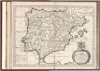
Wells, Edward, 1667-1727
Full Title
A new map of present Spain & Portugal. Shewing their principal divisions, cheif cities, townes, ports, rivers, mountains &c. R. Spofforth sculp. (to accompany) A new sett of maps both of antient and present geography. 6.
List No
11181.009
Note
Copper engraved double page map. Shows present political and administrative divisions. Includes abbreviations. Relief shown pictorially.
Author
Wells, Edward, 1667-1727
Full Title
A new map of ancient Gaul or Gallia Transalpina shewing the divisions thereof by Augustus Caesar together with its principal people cities townes rivers mountains &c. R. Spofforth sculp. (inset) Gallia divided according to Julius Caesar's Commentaries. (to accompany) A new sett of maps both of antient and present geography. 7.
List No
11181.010
Note
Copper engraved double page map with inset. Shows ancient political and administrative divisions. Includes abbreviations. Relief shown pictorially.
Author
Wells, Edward, 1667-1727
Full Title
A new map of France shewing its principal divisions cheif cities, townes, ports, rivers, mountains &c. R. Spofforth sculp. (to accompany) A new sett of maps both of antient and present geography. 8.
List No
11181.011
Note
Copper engraved double page map. Shows administrative divisions. Includes abbreviations. Relief shown pictorially.
Author
Wells, Edward, 1667-1727
Full Title
A new map of Netherlands, or Low Countries, shewing their principal divisions, cities, townes, rivers &c. Sutton Nicholls sculp. (inset) A draught of the sea coasts of Holland and parts adjoining, as they are supposed to have been in antient times. (to accompany) A new sett of maps both of antient and present geography. 9.
List No
11181.012
Note
Copper engraved double page map with inset. Covers the Netherlands, Belgium, Luxemburg, and part of Germany. Shows administrative divisions. Includes abbreviations.
Author
Wells, Edward, 1667-1727
Full Title
A new map of the Brittish Isles shewing their antient people, cities, and towns of note, in the time of the Romans. Sutton Nicholls sculp. (to accompany) A new sett of maps both of antient and present geography. 10
List No
11181.013
Note
Copper engraved double page map. Shows ancient political and administrative divisions. Includes explanations. Relief shown pictorially.
Author
Wells, Edward, 1667-1727
Full Title
A new map of the Brittish Isles shewing their present genl. divisions, cities, and such other towns, or places, as answer to the towns of note in the time of the Romans. Sutton Nicholls sculp. (to accompany) A new sett of maps both of antient and present geography. 11.
List No
11181.014
Note
Copper engraved double page map. Shows present political and administrative divisions. Includes explanations. Relief shown pictorially.
Author
Wells, Edward, 1667-1727
Full Title
A new map of antient Germany, Rhaeia, Vindelicia, and Noricum. Shewing their principal people, tribes, cities, towns, rivers, mountains, &c. Sutton Nicholls sculp. (to accompany) A new sett of maps both of antient and present geography. 12.
List No
11181.015
Note
Copper engraved double page map. Shows ancient political and administrative divisions. Includes explanations. Relief shown pictorially.
Author
Wells, Edward, 1667-1727
Full Title
A new map of Germany, shewing its principal divisions, cities, towns, rivers, mountains, &c. Sutton Nicholls sculp. (to accompany) A new sett of maps both of antient and present geography. 13.
List No
11181.016
Note
Copper engraved double page map. Shows administrative divisions. Includes explanations. Relief shown pictorially.
Author
Wells, Edward, 1667-1727
Full Title
A new map of antient Italy, together with the adjoyning islands of Sicily, Sardinia, and Corsica, shewing their principal divisions, cities, towns, rivers, mountains &c. Sutton Nicholls sculp. (to accompany) A new sett of maps both of antient and present geography. 14.
List No
11181.017
Note
Copper engraved double page map. Shows ancient administrative divisions. Includes abbreviations. Relief shown pictorially.
Author
Wells, Edward, 1667-1727
Full Title
A new map of present Italy, together with the adjoyning islands of Sicily, Sardinia, and Corsica, shewing their principal divisions, cities, towns, rivers, mountains &c. Sutton Nicholls sculp. (to accompany) A new sett of maps both of antient and present geography. 15.
List No
11181.018
Note
Copper engraved double page map. Shows present administrative divisions. Includes explanations. Relief shown pictorially.
Author
Wells, Edward, 1667-1727
Full Title
A new map of Gallia Cisalpina & Graecia Magna : shewing their cheif divisions, people, cities, towns &c. Sutton Nicholls sculp. (to accompany) A new sett of maps both of antient and present geography. 16.
List No
11181.019
Note
2 copper engraved double page maps on 1 sheet. Shows administrative divisions. Includes explanations and compass rose. Relief shown pictorially.
Author
Wells, Edward, 1667-1727
Full Title
A New Map of Latium Etruria and as much of Antient Italy as lay Between Gallia Cisalpina and Graecia Magna, Shewing its Principal Divisions, Cities, Towns, Rivers &c. Sutton Nicholls sculp. (to accompany) A new sett of maps both of antient and present geography. 17.
List No
11181.020
Note
Copper engraved double page map of central Italy. Shows administrative divisions. Includes explanations and compass rose. Relief shown pictorially.
Author
Wells, Edward, 1667-1727
Full Title
A new map of antient Greece, Thrace, Moesia, Illyricum, and the Isles adjoyning. Ed. Smith sculp. (to accompany) A new sett of maps both of antient and present geography. 18.
List No
11181.021
Note
Copper engraved double page map. Shows political and administrative divisions. Relief shown pictorially.
Author
Wells, Edward, 1667-1727
Full Title
A new map of Turky in Europe and parts adjoyning shewing their principal divisions and chiefe cities, towns, rivers, mountains &c. Ed. Smith sculp. (to accompany) A new sett of maps both of antient and present geography. 19.
List No
11181.022
Note
Copper engraved double page map. Shows political and administrative divisions. Relief shown pictorially. Includes abbreviations.
Author
Wells, Edward, 1667-1727
Full Title
A new map of the So. & mid. parts of antient Greece viz. Epirus, Hellas, or Graecia Propria, and Peloponnesus, together with the adjoyning islands. Ed. Smith sculp. (to accompany) A new sett of maps both of antient and present geography. 20.
List No
11181.023
Note
Copper engraved double page map. Shows political and administrative divisions. Relief shown pictorially. Includes explanations.
Author
Wells, Edward, 1667-1727
Full Title
A new map of antient Thrace : as also of the northern parts of old Greece, viz. Macedonia and Thessalia. Sutton Nicholls sculp. (to accompany) A new sett of maps both of antient and present geography. 21.
List No
11181.024
Note
Copper engraved double page map. Shows political and administrative divisions. Relief shown pictorially. Includes explanations and compass rose.
Author
Wells, Edward, 1667-1727
Full Title
A new map of the islands of the Aegaean Sea, together with the island of Crete, and the adjoining isles, Sutton Nicholls sculp. (to accompany) A new sett of maps both of antient and present geography. 22.
List No
11181.025
Note
Copper engraved double page map. Relief shown pictorially. Includes explanations and compass rose.
Author
Wells, Edward, 1667-1727
Full Title
A new map of Sarmatia, Europaea Pannonia and Dacia shewing their principal divisions, people, cities, towns, rivers, mountains &c. Benj. Cole sculp. (inset) A draught of the North Parts of Europe according to the erroneous opinion of some of the Ancients. (to accompany) A new sett of maps both of antient and present geography. 23.
List No
11181.026
Note
Copper engraved double page map. Showing political divisions. Relief shown pictorially. Includes explanations.
Author
Wells, Edward, 1667-1727
Full Title
A new map of present Poland, Hungary, Walachia, Moldavia, Little Tartary &c. shewing their principall divisions, chief cities, towns, rivers &c. B. Cole sculp. (to accompany) A new sett of maps both of antient and present geography. 24.
List No
11181.027
Note
Copper engraved double page map. Showing political divisions. Relief shown pictorially. Includes explanations.
Author
Wells, Edward, 1667-1727
Full Title
A new map of ancient Scandinavia together with as much more of ye northern part of ancient Europe as answers to present Denmark & Moscovia. (inset) Present Denmark with the adjoining parts of Sweden and Germany. (to accompany) A new sett of maps both of antient and present geography. 25.
List No
11181.028
Note
Copper engraved double page map. Showing political divisions. Relief shown pictorially. Includes abbreviations.
Author
Wells, Edward, 1667-1727
Full Title
A new map of Denmark, Norway, Sweden & Moscovy, shewing their present general divisions, cheif cities or towns, rivers, mountains &c. J. Moxon sculp. (to accompany) A new sett of maps both of antient and present geography. 26.
List No
11181.029
Note
Copper engraved double page map. Showing political divisions. Relief shown pictorially. Includes abbreviations.
Author
Wells, Edward, 1667-1727
Full Title
A new map of ancient Asia. delin. M Burg. sculp. Univ. Oxon. (to accompany) A new sett of maps both of antient and present geography. 27.
List No
11181.030
Note
Copper engraved double page map. Showing political divisions. Relief shown pictorially. Includes abbreviations.
Author
Wells, Edward, 1667-1727
Full Title
A new map of present Asia. Present Asia distinguisht into its general divisions or countries together with their capital cities, chief rivers, mountains, &c. delin. M Burg. sculp. Univ. Ox. (to accompany) A new sett of maps both of antient and present geography. 28.
List No
11181.031
Note
Copper engraved double page map. Showing political divisions. Relief shown pictorially. In cartouche, upper left: A new map of ancient Asia. Includes abbreviations.
Author
Wells, Edward, 1667-1727
Full Title
A new map of Great Tartary, and China : with the adjoyning parts of Asia, taken from M. de Fers Map of Asia. Sutton Nicholls sculp. (insets) This draught of the country to the NE of China is made according to the memory of Martini the Jesuite &c. (with) This draught of the country to the NNE and East of China is according to the memory of Verbiest the Jesuite. (to accompany) A new sett of maps both of antient and present geography. 29.
List No
11181.032
Note
Copper engraved double page map. Showing political divisions. Relief shown pictorially. Includes notes, compass rose and explanations. Prime meridians are Ferro and London.
Author
Wells, Edward, 1667-1727
Full Title
A new map of the East Indies, taken from Mr. de Fer's map of Asia, shewing their cheif divisions, cities, towns, ports, rivers, mountains &c. Sutton Nicholls sculp. (to accompany) A new sett of maps both of antient and present geography. 30.
List No
11181.033
Note
Copper engraved double page map. Showing political divisions. Relief shown pictorially. Includes compass rose and explanations. Prime meridians are Ferro and London.
Author
Wells, Edward, 1667-1727
Full Title
A New Map of the Western parts of Asia Minor largely taken: shewing their antient divisions, countries or people, chiefe cities, towns, rivers, mountains etc. R. Spofforth sculp. (to accompany) A new sett of maps both of antient and present geography. 31.
List No
11181.034
Note
Copper engraved double page map. Showing political divisions. Relief shown pictorially. Includes abbreviations.
Author
Wells, Edward, 1667-1727
Full Title
A new map of the eastern parts of Asia Minor largely taken as also of Syria, Armenia, Mesopotamia &c. shewing their antient divisions, countries or people, chiefe cities, towns, rivers, mountains &c. R. Spofforth sculp. (to accompany) A new sett of maps both of antient and present geography. 32.
List No
11181.035
Note
Copper engraved double page map. Showing political divisions. Relief shown pictorially. Includes abbreviations.
Author
Wells, Edward, 1667-1727
Full Title
A new map shewing the travels of the Patriarchs, as also of the children of Israel, from Egypt through the wildnerness, to the Land of Canaan. Sutton Nicholls sculp. (inset) This draught shews the several countries or people lying most remote from the Holy Land and mentioned in the Old Testament. (to accompany) A new sett of maps both of antient and present geography. 33.
List No
11181.036
Note
Copper engraved double page map of the Holy Land, with an inset map of the travels of the Patriarchs. Showing political divisions. Inset covers Mediterranean and the Near East, from Spain to Persia. Relief shown pictorially. Includes abbreviations.
Author
Wells, Edward, 1667-1727
Full Title
A new map of the Land of Canaan and parts adjoining shewing the division thereof among the twelve tribes of Israel. Sutton Nicholls sculp. (to accompany) A new sett of maps both of antient and present geography. 34.
List No
11181.037
Note
Copper engraved double page map. Inset: continuation map at a smaller scale of the Kingdom of Zobah, north of Syria. Map shows the shoreline of Zidon to River of Egypt. Jordan River is not shown. Relief shown pictorially. Includes explanation and compass rose.
Author
Wells, Edward, 1667-1727
Full Title
A new map shewing all the severall countries, cities, towns, and other places mentioned in the New Testament. Sutton Nicholls sculp. (with) New map showing all the several countries, cities, towns, and other places mentioned in the New Testament. (with) This draught shews the severall regions mentioned in the New Testamt. together with the cities & towns most remote from ye Holy Land, as in Italy, Mesopotamia &c. (to accompany) A new sett of maps both of antient and present geography. 35.
List No
11181.038
Note
3 copper engraved double page maps on 1 sheet. Note in map 1: This draught shews such places ... as were in the Holy Land, and parts adjoining. Relief shown pictorially. Includes notes.
Author
Wells, Edward, 1667-1727
Full Title
A new map of Libya or old Africk shewing its general divisions, most remarkable countries or people, cities, townes, rivers, mountains &c. R. Spofforth sculp. (to accompany) A new sett of maps both of antient and present geography. 36.
List No
11181.039
Note
Copper engraved double page map of ancient Africa. Relief shown pictorially. Includes abbreviations.
Author
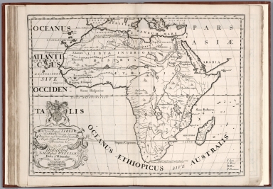
Wells, Edward, 1667-1727
Full Title
A new map of Africk shewing its present divisions, cheif cities or townes, rivers, mountains &c. R. Spofforth sculp. (to accompany) A new sett of maps both of antient and present geography. 37.
List No
11181.040
Note
Copper engraved double page map of present Africa. Relief shown pictorially. Includes abbreviations.
Author
Wells, Edward, 1667-1727
Full Title
A new map of the north part of antient Africa shewing the chiefe people, cities, towns, rivers, mountains, &c. in Mauritania, Numidia, Africa Propria, Libya Propria and Egypt. R. Spofforth sculp. (to accompany) A new sett of maps both of antient and present geography. 38.
List No
11181.041
Note
Copper engraved double page map of North Africa. Relief shown pictorially. Includes abbreviations and compass rose.
Author
Wells, Edward, 1667-1727
Full Title
A new map of North America shewing its principal divisions, chief cities, townes, rivers, mountains &c. Delin. M. Burg., sculpt., Univ. Oxon. (to accompany) A new sett of maps both of antient and present geography. 39.
List No
11181.042
Note
Copper engraved double page map of North America. Showing many of the early English settlements and American Colonial cities. Relief shown pictorially. Includes abbreviations. and annotations and dates of discovery.
Author
Wells, Edward, 1667-1727
Full Title
A new map of South America shewing its general divisions, chief cities, towns, rivers, mountains &c. Delin. B. Cole, sculpt., Univ. Oxon. (to accompany) A new sett of maps both of antient and present geography. 40.
List No
11181.043
Note
Copper engraved double page map of South America. Relief shown pictorially. Includes abbreviations.
Author
Wells, Edward, 1667-1727
Full Title
A new map of the most considerable plantations of the English in America. Sutton Nicolls sculp. (insets) New Scotland. (with) I. of Jamaica. (with) I. of Barbados. (with) Bermudaz or Sommers Isles. (with) Carolina. (to accompany) A new sett of maps both of antient and present geography. 41.
List No
11181.044
Note
Copper engraved double page map of the British Colonies in North America at the beginning of the 1700s. Includes explanations.
1-41 of 41
|