|
REFINE
Browse All : School Atlas of South America
1-96 of 96
Author
Logerot, A. (Auguste)
Full Title
[North and South America.] A. Logerot.
List No
14489.044
Note
Manuscript map representing North and South America. Shows select regions, mountain ranges, drainage, bodies of water, coastlines, and islands. Relief shown with shading. Ink, pencil, and watercolor on paper. Map is 31 x 23 cm, on sheet 31 x 23 cm.
Author
Logerot, A. (Auguste)
Full Title
[South America.] A. Logerot.
List No
14489.045
Note
Manuscript map representing South America. Shows select regions, mountain ranges, drainage, coastlines, and islands. Relief shown with shading. Ink, pencil, and watercolor on paper. Map is 22 x 28 cm, on sheet 30 x 23 cm.
Author
[Ravenstein, August, Berlin Geographisch-Artistische Anstalt Ernst Schotte]
Full Title
Südamerika. Zeichnung u. Modell von August Ravenstein in Frankfurt a. M. Stich, Prägung, Druck u. Verlag von B. Dondorf in Frankfurt a. M.
List No
14473.008
Note
Relief map of South America. Shows geographical regions, countries, cities, railways, topography, vegetation, bodies of water, drainage, coastlines, shoals and islands. Topography shown with raised relief. Includes a legend, bar scale given in miles, latitudinal and longitudinal lines, as well as statistical and descriptive notes. Additional legend for map appears on title page. With an indexed vignette of scenery, figures, fauna and flora. Colored lithograph. Map is 27 x 22 cm, within frame 28 x 24 cm. Within a series of eight maps comprising the school atlas, Plastischer Schul-Atlas.
Author
Anestis Konstantinidis, 1846-190
Full Title
Norios Ameriki. Anésti konstantinidis Ekdotie (to accompany) Neótatos geografikos atlas. En Athēnais 1895.
List No
13551.022
Note
Map of South America.
Author
Smiley, Thomas T.
Full Title
South America. Engraved by E.F. Woodward.
List No
0902.008
Note
In full color by country. South American vignette of a native Peruvian.
Full Title
South America. Published by Lincoln & Edmands, Boston, (1819)
List No
0004.004
Note
Uncolored engraved map. Relief shown pictorially.
Full Title
South America. Published by Lincoln & Edmands, Boston. (1832)
List No
0006.006
Note
Engraved map. Outline hand col. Relief shown by hachures.
Full Title
South America. Philad., Published by M. Carey & Son, 1820. (1825)
List No
0124.014
Note
Engraved map. Relief shown pictorially.
Author
Cartee, Cornelius S.
Full Title
Map of South America. Designed To Accompany Cartee's "Elements Of Physical Geography. Engraved by G.W. Boynton. Entered ... 1856, by Hickling, Swan, And Brown ... Massachusetts. (to accompany) A School Atlas Of Physical Geography ... By Cornelius S. Cartee, A.M. M DCCC LVI.
List No
0129.007
Note
Hand color map. Includes explanation. Shows regions, cities, rivers. Relief shown by hachures and spot heights. Prime meridian is Greenwich.
Author
Cornell, S. S. (Sarah S.)
Full Title
South America. Designed to accompany Cornell's High school geography. Entered ... 1855, by S.S. Cornell ... Southern District of New York. New York: D. Appleton & Co., 443 & 445 Broadway. (1864)
List No
0197.017
Note
Engraved map. Hand colored. Relief shown by hachures.
Author
[Diercke, Carl, Gaebler, Eduard]
Full Title
Sud - Amerika: Meeresgebiete u. temperatur. (with 4 insets). (to accompany) Diercke Schul-Atlas fur hohere Lehranstalten. "17" on the lower right margin.
List No
0243.046
Note
Color map with 4 insets: Isthmus von Tehuantepec. Isthmus von Nicaragua. Isthmus von Panama. Isthmus von darien. Relief shown by hachures. Prime meridian is Greenwich.
Author
[Diercke, Carl, Gaebler, Eduard]
Full Title
Sud - Amerika. Diercke u. Gaebler, Schulatlas fur hohere Lehranstalten. Druck und Verlag : Braunschweig, George Westermann. (to accompany) Diercke Schul-Atlas fur hohere Lehranstalten.
List No
0243.047
Note
Color map. Relief shown by hachures. Prime meridian is Greenwich.
Author
[Diercke, Carl, Gaebler, Eduard]
Full Title
Sud - Amerika: Vegetations - u. Regenkarte. Volkerkarte und Bevolkerungsdichte. (to accompany) Diercke Schul-Atlas fur hohere Lehranstalten. "18" on the lower right margin. (with 8 insets).
List No
0243.048
Note
Color map. With insets of major cities. Relief shown by hachures. Prime meridian is Greenwich.
Author
[Diercke, Carl, Gaebler, Eduard]
Full Title
Sud - Amerika, Staatenkarte. Diercke u. Gaebler, Schulatlas fur hohere Lehranstalten. Druck und Verlag : Braunschweig, George Westermann. (to accompany) Diercke Schul-Atlas fur hohere Lehranstalten.
List No
0243.049
Note
Color map on 2 pages. Shows countries and regions. Relief shown by hachures. Prime meridian is Greenwich.
Author
Duval, Henri
Full Title
Atlas Universel. Tableau historique et geographique de l'Amerique meridionale. Par Henri Duval, Chevalier de la Legion d'honneur, Professeur d'Histoire, de Geographie, de Belles-lettres, & &. Paris (1834), Chez l'Auteur, rue de la Chaussee d'Antin, No.15... Johanneau, Rue du Coq. 8 bis. ,,, Impie. lith. de E. Houbloup, rue Dauphine 22 et 24.
List No
0254.028
Note
Map of South America with descriptions of historic events and famous personages. Hand tinted text to match regions. Relief shown by simple hachures.
Author
[Burritt, Emma, Fitch, George W.]
Full Title
South America. Drawn by (to be filled in. By George W. Fitch. New York: Sheldon, Blakeman and Company, 115 Nassau Street. Entered ... 1850, by Huntington and Savage ... New York)
List No
0289.006
Note
Printed map form with title, grid lines and numbers or "mapping plate." Map data added including relief by hachures in pen-and-ink by Emma Burritt Prime meridians: Greenwich and Washington.
Full Title
South America. J.H. Young Sc. (Philadelphia: John Grigg, No. 9 North Fourth Street. 1830)
List No
0315.012
Note
Engraved map. Full hand color. Relief shown pictorially. Prime meridians: Greenwich and Washington.
Full Title
Colombia and Guiana. J.H. Young Sc. (Philadelphia: John Grigg, No. 9 North Fourth Street. 1830)
List No
0315.013
Note
Engraved map. Full hand color. Relief shown pictorially. Prime meridians: Greenwich and Washington.
Full Title
Brazil, Bolivia & Peru. J.H. Young Sc. (Philadelphia: John Grigg, No. 9 North Fourth Street. 1830)
List No
0315.014
Note
Engraved map. Full hand color. Relief shown pictorially. Prime meridians: Greenwich and Washington.
Full Title
United Provinces, Chili & Patagonia. J.H. Young Sc. (Philadelphia: John Grigg, No. 9 North Fourth Street. 1830)
List No
0315.015
Note
Engraved map. Full hand color. Relief shown pictorially. Covers also Paraguay and Uruguay. Prime meridians: Washington and Greenwich.
Author
Delamarche, Charles Francois
Full Title
Amerique Meridionale divisee en ses principaux etats, avec privilege. A Paris, ches Delamarche, Geo., Rue du Foin St. Jacques. (ca. 1800)
List No
0421.026
Note
Engraved map. Outline hand coloring. Relief shown pictorially. Prime meridian: Ferro.
Author
Mitchell, Samuel Augustus
Full Title
Map of South America. Entered ... 1839, by S. Augustus Mitchell ... Pennsylvania.
List No
0522.003
Note
Without color. Dotted divisions between countries. Capital cities shown by stars.
Author
Mitchell, Samuel Augustus
Full Title
Map of South America. Engraved to Illustrate Mitchell's School and Family Geography. No. 10. Engraved by J.H. Young. Entered ... 1839, by S. Augustus Mitchell ... Connecticut.
List No
0523.008
Note
In full color by country. Includes explanation of symbols used to represent towns, railroads, canals and distance.
Full Title
South America. J.W. Barber sc. (with) British Isles. (Published by Richardson & Lord. Sold also by Collins & Hannay, New-York, 1828)
List No
0627.003
Note
Engraved map with inset. Hand colored. Relief shown by hachures.
Author
شكوفه مقبل [Şukufe Mukbil]
Full Title
(Rivers of South America)
List No
10992.039
Note
Dimensions are sheet size.
Author
شكوفه مقبل [Şukufe Mukbil]
Full Title
(South America with Railroads)
List No
10992.045
Note
Dimensions are sheet size. Has flag of Argentina on opposite page.
Author
[Grenet, Abbe, Bonne, Rigobert]
Full Title
Carte generale de l'Amerique Meridionale. Par M. Bonne, ingenir. Hydrographe de la Marine. A' Venise, 1789 Par P. Santini. (to accompany) Atlas portatif a l'usage des colleges, pour servir a l'intelligence des auteurs classiques. 43.
List No
11172.046
Note
Copper engraved outline hand colored map. Map showing boundaries, numerous cities and towns. Prime meridians are Paris and Ferro. Relief shown pictorially.
Author
Wells, Edward, 1667-1727
Full Title
A new map of South America shewing its general divisions, chief cities, towns, rivers, mountains &c. Delin. B. Cole, sculpt., Univ. Oxon. (to accompany) A new sett of maps both of antient and present geography. 40.
List No
11181.043
Note
Copper engraved double page map of South America. Relief shown pictorially. Includes abbreviations.
Author
[Meissas, Achille, 1799-187, Michelot, Auguste Jean Charles, 1792-1854]
Full Title
Amerique Meridionale : Par MM. Achille Meissas et Auguste Michelot. 1854. A la Librairie de L. Hachette. Grave sur acier par Dumortier, Ecrit par P.Rousset. Charle, del. (to accompany) Petit atlas universel de geographie Ancienne du Moyen Age et Moderne et de geographie sacree. (insets) Guadeloupe. (with) Martinique.
List No
11740.029
Note
2 colored in outline double page steel engraving map of South America. Showing political divisions, major cities, rivers and mountains are shown. Relief shown by hachures.
Author
Lange, I. E.
Full Title
Sud - Amerika. (to accompany) Neuer hand und elementar atlas ... Entworfen von I.E. Lange. Leipzig 1809.
List No
11945.009
Note
Engraved and hand painted with outline color map. Shows political boundaries, major cities, rivers and mountains. Relief shown by hachures. Prime meridian is Ferro. Includes descriptive text on lower panel.
Author
[De Larochette, D'Anville]
Full Title
South America from the Latest Discoveries, Shewing the Spanish & Portuguese Settlements according to Mr. D. Anville. By De Larochette.
List No
12055.021
Note
Date estimated based on rest of atlas. "London printed for J. Bowles in St. Pauls Church Yard."
Author
[Diercke, Carl, 1842-1913, Gaebler, Eduard, 1842-1911]
Full Title
S22. Sued-America, Physikalisch.
List No
12198.026
Author
[Diercke, Carl, 1842-1913, Gaebler, Eduard, 1842-1911]
Full Title
S23. Sued-America, Politisch.
List No
12198.027
Author
Woodbridge, William C.
Full Title
South America. (engraved by) Perkins & Heath. London. Published by Whittaker, Treacher & Arnot.13 Ave-Maria-Lane, London. . (to accompany) Modern Atlas On A New Plan; To Accompany The System Of Universal Geography, By William Channing Woodbridge. Includes: Reference to Cities. Capitals. Large Town. Small Towns. Universities or Colleges. Figures 1. 2. 3. &c refers to Classes.
List No
1224.012
Note
Hand painted outline color map. Covers are quarter leather blue paper covered boards printed with "Modern Atlas On A New Plan; To Accompany The System Of Universal Geography, By William Channing Woodbridge. London: Published For The Proprietors, By Geo. B. Whittaker, Ave-Maria-Lane. 1828. Relief shown by hachures. Prime meridian is London.
Author
Woodbridge, William C.
Full Title
Political Map Of South America and Africa. Adapted To Woodbridge's Geography. Entered ... 1843, by W.C. Woodbridge ... Massachusetts. Hartford. Published By Wm. Jas. Hamersley. (to accompany) Modern Atlas, Physical, Political And Statistical; Exhibiting On Separate Maps ... (inset) Map Of the Andes. (inset map) Liberia.
List No
1229.017
Note
Map Printed with hand painted outline color. Includes References and Explanations showing Cities, Inhabitants, Small and Large towns, Universities or Colleges, and Capitals... Figures indicate the Rank of Rivers and Mountains. Covers are heavy brown paper printed with "School Atlas, To Accompany The Modern School Geography, By William C. Woodbridge ... Hartford: Published By Belknap & Hamersley. Entered ... 1843, by William C. Woodbridge ... Massachusetts. Case, Tiffany & Co. Printers, Hartford, Conn." Prime meridians are Greenwich and Washington D.C. Relief shown by hachures.
Author
Woodbridge, William C.
Full Title
Political Map Of South America And Africa. Adapted To Woodbridge's Geography. Entered .. . 1843, by W.C. Woodbridge ... Massachusetts. Hartford. Published By Wm. Jas. Hamersley. (inset) Map of Andes. (inset map) Liberia.
List No
1231.017
Note
Outline color map. Includes References and Explanations, showing Cities, Inhabitants, and Universities or Colleges. Covers are heavy brown paper printed with "School Atlas, To Accompany The Modern School Geography, By William C. Woodbridge ... Hartford: Published By Wm. Jas. Hamersley. Entered ... 1843, by William C. Woodbridge ... Massachusetts. Case, Tiffany & Co. Printers, Hartford, Conn." Prime meridian is London. Relief shown by hachures.
Author
[Woodbridge, William C., Willard, Emma]
Full Title
South America
List No
12497.007
Note
Shows South Georgia Islands, one of the earliest map to do so.
Author
[Brion de La Tour, Louis, 1743 – 1803, Desnos, Louis Charles]
Full Title
Chili, Paraguay, Bresil, Amazones et Perou. Par M. Brion. A Paris, chez le Sr. Desnos. A.P.D.R. 1786. (to accompany) Atlas general, civil, ecclesiastique et militaire, methodique et elementaire pour l'etude de la geographie et de l'histoire ... par M. Brion, dirige par le sr. Desnos … A Paris 1786.
List No
13129.055
Note
Engraved hand color map of South America. Includes decorative engraved title cartouche and border. Shows political boundaries. Relief shown pictorially. Includes legend.
Author
Faden, William, 1749-1836
Full Title
South America from the latest Spanish and Portuguese surveys. Published by Wm. Faden. Jany. 1,1819. W. Palmer, Sculp. (to accompany) Atlas minimus universalis, or, A geographical abridgement ancient and modern of the several parts of the earth ... Second edition. Jan 1, 1821.
List No
13243.074
Note
Double page outline hand color copperplate engraved map,. Shows political divisions, major cities and towns. Prime meridians and Ferro and London. Relief shown pictorially.
Author
Stieler, Adolf
Full Title
Sud America. (to accompany) Atlas ofver alla verldens delar. Upsala, Palmblad & Co. 1825.
List No
13428.029
Note
Engraved hand colored in outline map. Shows political boundaries. Includes list of Brasil administrative division.
Author
Ikbal Kutuphanesi Sahibi Huseyin
Full Title
Janubii Aamerika = South America. (to accompany) Tajadud maktab atlasi = New school atlas. 1927-1345.
List No
13435.009
Note
Political map. Shows capitals and major cities.
Author
Meḥmed Remzi
Full Title
Janubii Aamerika = South America. Cografya-yi ʻumumī atḷasi. stanbul : Mekteb-i Funun-ı Harbiye-i Sahanesi Matbaası, 1905=1323 h.
List No
13436.048
Note
Black and white outline map of south America on 2 pages. Relief shown by hachures. Includes 4 insets.
Author
Meḥmed Remzi
Full Title
Janubii Aamerika = South America. Cografya-yi ʻumumī atḷasi. stanbul : Mekteb-i Funun-ı Harbiye-i Sahanesi Matbaası, 1905=1323 h.
List No
13436.049
Note
Black and white outline map of south America on 2 pages, with manuscript geographical names. Relief shown by hachures. Includes 4 insets.
Author
Meḥmed Remzi
Full Title
Janubii Aamerika = South America. Cografya-yi ʻumumī atḷasi. stanbul : Mekteb-i Funun-ı Harbiye-i Sahanesi Matbaası, 1905=1323 h.
List No
13436.050
Note
Black and white outline map of south America on 2 pages, with manuscript geographical names. Relief shown by hachures. Includes 4 insets.
Author
Silishchensky, Mitrofan Ivanovich 1878 - 1944
Full Title
Iuzhnaya Amerika. Fizicheskaya. Afrika. Fizicheskaya. Prof. M. I. Silishchenskiy. Gos. Kartogr. Institut NTU-VSNKH-SSR. Kartografiya Leningrad. (to accompany) Geograficheskiy atlas Chast 1.
List No
13461.024
Note
2 maps on 1 sheet. Physical maps of South America at scale of 1:40,000,000 and Africa at scale of 1:60,000,000, with 2 profiles. Includes legend and color coded key.
Author
Silishchensky, Mitrofan Ivanovich 1878 - 1944
Full Title
Iuzhn. Amerika. Ekonomichesko-Politicheskaia karta. Prof. M. I. Silishchenskiy. Gos. Kartogr. Institut NTU-VSNKH-SSR. Kartografiya Leningrad. (to accompany) Geograficheskiy atlas Chast 1.
List No
13461.025
Note
Economical and political map of South America. Includes legend and color coded key.
Author
Meḥmed Remzi
Full Title
(Outline map of Sout America). Umumi jughrafia atlasi = Atlas of general geography. Assar Muhammad Ramzi, Maktab Harbiye Matbaa si. Mulayiyuh sanah 1325 (1907).
List No
13534.021
Note
Outline map of South America, with 4 insets.
Author
Meḥmed Remzi
Full Title
(Outline map of Sout America). Umumi jughrafia atlasi = Atlas of general geography. Assar Muhammad Ramzi, Maktab Harbiye Matbaa si. Mulayiyuh sanah 1325 (1907).
List No
13534.022
Note
Outline map of South America, with 4 insets. Copy 2.
Author
Hossein
Full Title
(Outline map of the South America) .جغرافیای عمومی اطلسی = Atlas of general geography. Istanbul 1300 (1923).
List No
13686.028
Note
Outline color map of South America.
Author
Weiland, C. F. (Carl Ferdinand), 1782-1847
Full Title
Süd America entworfen und gezeichnet von C. F. Weiland. Weimar, im Verlag des Geograph. Instituts, 1828.
List No
14365.061
Note
Map of South America, as of 1828. Shows political boundaries (including European colonies), cities, topography, bodies of water, drainage, coastlines and islands. Relief shown with hachures. Includes latitudinal and longitudinal lines, as well as a legend and four bar scales. With hand-drawn annotation in blue colored pencil. Hand-colored engraving. Map is 37 x 31 cm, on sheet 57 x 45 cm. (Plate number taken from table of contents.)
Author
Imhof, Eduard, 1895-1986
Full Title
Südbrasilien und La Plata-Länder -- Südamerika, südlicher Teil.
List No
14401.103
Note
Two maps of South America, featuring Southern Brazil, the La Plata River Basin and the southern part of South America, in 1969. Maps show topography, bodies of water, drainage, coastlines, islands and water depths. Maps include latitudinal and longitudinal lines, legends, bar scales and scale statements (scales differ). With inset map: Rio de Janeiro. Colored lithograph. Together, maps are 29 x 17 cm, on sheet 33 x 22 cm. Maps appear in section entitled Südamerika [= South America].
Author
Imhof, Eduard, 1895-1986
Full Title
Vegetation -- Wirtschaft.
List No
14401.104
Note
Two maps of South America, featuring vegetation and the economy, in 1969. Maps also show bodies of water, drainage, coastlines and islands. Maps include latitudinal and longitudinal lines, legends, bar scales and scale statements (scales differ). Colored lithograph. Together, maps are 29 x 17 cm, on sheet 33 x 22 cm. Maps appear in section entitled Südamerika : Thematische Karten [= South America : Thematic maps].
Author
Imhof, Eduard, 1895-1986
Full Title
Produkte 1 -- Produkte 2 -- Produkte 3 -- Produkte 4 -- Produkte 5 -- Produkte 6.
List No
14401.105
Note
Six maps of South America, featuring the products created across the continent, such as coffee, cocoa, vanilla, corn, tobacco, silver and gold, in 1969. Maps also show bodies of water, drainage, coastlines and islands. Maps include latitudinal and longitudinal lines, legends, bar scales and scale statements. Colored lithograph. Together, maps are 29 x 17 cm, on sheet 33 x 22 cm. Maps appear in section entitled Südamerika : Thematische Karten [= South America : Thematic maps].
Author
Imhof, Eduard, 1895-1986
Full Title
[Übersichtskarte].
List No
14401.106
Note
Overview map of South America, in 1969. Shows cities, railways, roads, topography, bodies of water, drainage, coastlines, islands, water depths and ship routes. Relief shown with shading and spot heights. Includes latitudinal and longitudinal lines, a legend, bar scale and scale statement. With inset map: Die Schweiz [Switzerland]. Colored lithograph. Map is 29 x 39 cm, on double sheet 33 x 44 cm. Appears in section entitled Südamerika [= South America].
Author
Imhof, Eduard, 1895-1986
Full Title
Tektonik -- Niederschläge.
List No
14401.107
Note
Two maps of North and South America, featuring plate tectonics and precipitation, in 1969. Maps also show bodies of water, drainage, coastlines and islands. Maps include latitudinal and longitudinal lines, legends, bar scales and scale statements. Colored lithograph. Together, maps are 29 x 17 cm, on sheet 33 x 22 cm. Maps appear in sections entitled Nord- und Mittelamerika : Thematische Karten [= North and Central America : Thematic maps] and Südamerika : Thematische Karten [= South America : Thematic maps].
Author
Imhof, Eduard, 1895-1986
Full Title
Politische Gliederung -- Sprachen der Kolonisten.
List No
14401.108
Note
Two maps of North and South America, featuring national political boundaries and languages spoken by colonialists throughout the area, in 1969. Maps also show cities, railways, bodies of water, drainage, coastlines and islands. Maps include latitudinal and longitudinal lines, legends, bar scales, scale statements (scales differ) and an explanatory note. Colored lithograph. Together, maps are 29 x 17 cm, on sheet 33 x 22 cm. Maps appear in sections entitled Nord- und Mittelamerika : Thematische Karten [= North and Central America : Thematic maps] and Südamerika : Thematische Karten [= South America : Thematic maps].
Author
Imhof, Eduard, 1895-1986
Full Title
Volksdichte -- Völker.
List No
14401.109
Note
Two maps of North and South America, featuring the population and variety in ethnicity, in 1969. Maps also show bodies of water, drainage, coastlines and islands. Maps include latitudinal and longitudinal lines, legends, bar scales, scale statements (scales differ) and an explanatory note. Colored lithograph. Together, maps are 29 x 17 cm, on sheet 33 x 22 cm. Maps appear in sections entitled Nord- und Mittelamerika : Thematische Karten [= North and Central America : Thematic maps] and Südamerika : Thematische Karten [= South America : Thematic maps].
Author
Stanford, Edward
Full Title
South America
List No
15996.019
Note
Date estimated.
Author
Huntington, Francis Junius, 1802-1878
Full Title
North America. South America. Entered ... 12th day of August 1830 by F.J. Huntington ... Connecticut. Engraved upon steel by E. Huntington.
List No
1902.006
Note
Two engraved maps. Hand colored. Relief shown pictorially and by hachures. Prime meridians: Greenwich and Washington.
Full Title
South America. Entered ... 1836, by Eleazer Huntington ... Connecticut.
List No
2022.011
Note
Engraved map. Hand colored. Relief shown by hachures. Shows settlements, rivers, etc. Prime meridians: Greenwich and Washington.
Author
Cummings, Jacob Abbot
Full Title
South America. Published by Cummings & Hilliard, No. 1, Cornhill, Boston. W. B. Annin, sc. (to accompany) An Ancient And Modern Atlas, Containing Thirteen Ancient And Eight Modern Maps.
List No
2106.006
Note
Engraved outline hand color map. Relief shown pictorially.
Author
Young, J.
Full Title
The northern part of South America. By J. Young Geogr. Published as the Act directs 1st July 1778. (to accompany) A New Atlas Or a Compleat (sic) Set of Maps Representing the different Empires, Kingdoms & States of the Known World Including all the Modern Discoveries, By J. Young, A.M.
List No
2226.024
Note
Engraved hand color double page outline map. Shows political boundaries, rivers, lakes, and mountains. Relief shown pictorially.
Author
Young, J.
Full Title
The southern part of South America. By J. Young Geogr. Published as the Act directs 1st July 1778. (to accompany) A New Atlas Or a Compleat (sic) Set of Maps Representing the different Empires, Kingdoms & States of the Known World Including all the Modern Discoveries, By J. Young, A.M.
List No
2226.025
Note
Engraved hand color double page outline map. Shows political boundaries, rivers, lakes, and mountains. Relief shown pictorially.
Author
Patteson, Edward
Full Title
South America. E.P. delint. Mutlow Sc., Russell Cot. (1804)
List No
2319.015
Note
Engraved outline map to be completed by students. Faces a corresponding map with place names, etc. Relief shown by hachures.
Author
Patteson, Edward
Full Title
South America. E.P. delint. Mutlow Sc., Russell Cot. Publish'd 15th June, 1804, by the Revd. E. Patteson, Richmond, Surrey.
List No
2319.016
Note
Engraved map. Boundaries in outline color. Faces a corresponding outline map. Relief shown by hachures. Shows settlements, Indian tribes, etc.
Author
D.F. Robinson & Co.
Full Title
South America. Entered according to Act. of Congress Nov. 20th 1829 by D.F. Robinson & Co. of the state of Connecticut.
List No
2430.009
Note
Engraved map. Hand colored. Relief shown by hachures. Shows cities with populations, rivers, etc. Prime meridians: Greenwich and Washington.
Author
[Morse, H., Worcester, J. E.]
Full Title
South America. H. Morse Sc. Published by Cummings & Hilliard, No. 1 Cornhill, Boston. (ca. 1821)
List No
2450.004
Note
Engraved map. Hand colored. Relief shown by hachures.
Author
Woodbridge, William C.
Full Title
Comparative, geographical & statistical map of South America & Africa, presenting a view of the Atlantic Ocean, adapted to Woodbridge's Geography. (with) Enlarged map of New Granada, Peru & Upper Peru. Entered ... 1831, by William C. Woodbridge ... Connecticut. (1837?)
List No
2573.011
Note
Engraved map. Hand colored. Relief shown by hachures.
Full Title
Sud-America. (Efter Stielers Hand-Atlas. Stockholm, J.L. Brudin, 1852)
List No
2605.007
Note
Engraved map. Outline hand coloring. Relief shown by hachures. In German. Prime meridian: Ferro.
Author
Monin, C.V.
Full Title
Amerique Meridionale dressee par N. Lorraine Pere, attache au Depot General de la Guerre. Hoquart aine Editeur. Grave par Lale.
List No
2613.019
Note
Counties outlined in color. Four scales. Prime meridian Paris. Relief shown with hachures.
Author
Cummings, J. A. (Jacob Abbot)
Full Title
South America. Published by Cummings & Hilliard, No. 1, Cornhill. H. Morse Sc. (1821?)
List No
2640.004
Note
Engraved map. Outline hand color. Relief shown pictorially.
Full Title
South America. Philad. Published by M. Carey & Son, 1820.
List No
2682.014
Note
Engraved map. Outline hand color. Relief shown pictorially.
Author
[Cleobury, Miss., Wilkinson, R.]
Full Title
(Text Page to) South America. (to accompany) Practical Geography; In A Series of Exercises, Illustrative Of The Geography Of All The Countries In The Civilized World ... By Miss Cleobury, Of Nottingham. 1815.
List No
2687.079
Note
Series of geographical inquiries about South America.
Author
[Cleobury, Miss., Wilkinson, R.]
Full Title
South America. Copied from Wilkinson's General Atlas. (to accompany) Practical Geography; In A Series of Exercises, Illustrative Of The Geography Of All The Countries In The Civilized World ... By Miss Cleobury, Of Nottingham. 1815.
List No
2687.080
Note
Outline color map. Relief shown pictorially. Prime meridian is Greenwich.
Author
[Cleobury, Miss., Wilkinson, R.]
Full Title
(Text Page to) South America. (to accompany) Practical Geography; In A Series of Exercises, Illustrative Of The Geography Of All The Countries In The Civilized World ... By Miss Cleobury, Of Nottingham. 1815.
List No
2687.081
Note
Series of answers to geographical inquiries about South America.
Author
Woodbridge, William C.
Full Title
South America. Engraved by Engraved for Woodbridge's Rudiments of Geography. Entered ... 1821, by William C. Woodbridge ... Cunnecticut. ( to accompany) Woodbridge's Larger Atlas. Atlas On A New Plan, Exhibiting The Prevailing Religions, Forms Of Government, Degrees Of Civilization, And The Comparative Size Of Towns, Rivers And Mountains. By William C. Woodbridge, A.M. ... Hartford: Published by Samuel G. Goodrich ...
List No
3024.006
Note
Map is hand painted with outline color. Includes references to cities, capitals, large towns, small towns. Figures 1,2,3, refers to classes. Covers are marbled paper covered cardboard 25x16 with a paper label printed with title "Woodbridge's Larger Atlas. Atlas On A New Plan, Exhibiting The Prevailing Religions, Forms Of Government, Degrees Of Civilization, And The Comparative Size Of Towns, Rivers And Mountains. By William C. Woodbridge, A.M. ... Hartford: Published by Samuel G. Goodrich." in black. Prime meridian is London. Relief shown by hachures.
Author
Mitchell, Samuel Augustus
Full Title
Map of South America. Engraved to illustrate Mitchell's school and family geography. Engraved by J.H. Young. Entered ... 1839 by S. Augustus Mitchell ... Connecticut.
List No
3559.010
Note
Engraved map. Hand colored. Relief shown by hachures and spot heights. Shows rivers, country populations, Indian tribes, cities with populations, etc. Prime meridians: Greenwich and Washington.
Author
Melish, John
Full Title
E: (Untitled outline map of South America).
List No
3562.006
Note
Uncolored map.
Full Title
South America. Published by Hilliard, Gray, Little & Wilkins, Boston. H. Morse Sc. (1829)
List No
4493.006
Note
Engraved map. Outline hand color. Relief shown by hachures. Prime meridians: Washington and Greenwich.
Full Title
South America. N. & S.S. Jocelyn Sculpt. (Boston: Published by Richardson & Lord. 1820)
List No
4494.005
Note
Engraved map. Outline hand color. Relief shown by hachures.
Author
Woodbridge, William C.
Full Title
South America. Entered ... 1821, by William.C. Woodbridge ... Connecticut. (inset) Northern Division Of The United States. (to accompany) Modern Atlas On A New Plan; To Accompany The System Of Universal Geography, By William Channing Woodbridge ... Exhibiting In Connection With The Outlines Of Countries, The Prevailing Religions, Forms Of Government, And Degrees Of Civilization; The Comparative Size Of Towns, Rivers And Mountains; And The Climates And Productions Of The Earth ... District Of Connecticut, ss. Be It Remembered, That on the twenty-second day of June, in the forty-eighth year of the Independence of the United States of America, William Channing Woodbridge ... and Emma Willard ... have deposited in this Office the title of a book ... Charles A. Ingersoll, Clerk of the District of Connecticut. Hartford: Oliver D. Cooke & Sons, Publishers.
List No
4602.010
Note
Full color map. Relief shown by hachures. Includes references to Cities, Capitals, Large and Small Towns, Missionary Stations. figures 1,2,3, refer to classes. And Universities or Colleges. Bound in quarter leather tan boards with the above title, the table of contents and a decorative border printed in black. Prime meridian is London.
Author
Clouet, J. B. L. (Jean-Baptiste Louis), b. 1730
Full Title
Du Mexique. (with) La Terre Ferme. (1787)
List No
4757.066
Note
Abbot Jean Baptiste Louis Clouet (c. 1730 – 1790) was a French cartographer active in the mid to late 18th century. Clouet held the post of Royal Geographer of the Academie des Sciences de Rouen, he had offices in Paris and Cadiz. Clouet’s most important work is his Geographie Moderne, which was published in various editions from 1776 – 1793. Clouet also produced a series of stunning and highly decorative wall maps depicting the various continents. He followed in the footsteps of Jean-Baptiste Nolin and other French cartographers, reissuing these grand wall-maps in the latter part of the 18th century to decorate the houses of Paris and more unusually Spain.
Author
Clouet, J. B. L. (Jean-Baptiste Louis), b. 1730
Full Title
Du Perou, du Chili, Pays des Amazones, du Bresil, du Paraguay. (1787)
List No
4757.067
Note
Abbot Jean Baptiste Louis Clouet (c. 1730 – 1790) was a French cartographer active in the mid to late 18th century. Clouet held the post of Royal Geographer of the Academie des Sciences de Rouen, he had offices in Paris and Cadiz. Clouet’s most important work is his Geographie Moderne, which was published in various editions from 1776 – 1793. Clouet also produced a series of stunning and highly decorative wall maps depicting the various continents. He followed in the footsteps of Jean-Baptiste Nolin and other French cartographers, reissuing these grand wall-maps in the latter part of the 18th century to decorate the houses of Paris and more unusually Spain.
Author
[Carey, Henry Charles, Lea, Isaac]
Full Title
South America (to accompany) The Juvenile Atlas or a Series Of Maps, To Illustrate the Old and New Worlds ...1822.
List No
4884.038
Note
Uncolored engraved map. The map shows countries, regions, important cities, and rivers. Relief shown by hachures. Prime meridian is London.
Author
Woodbridge, William C.
Full Title
South America. Entered ... 1821 by William C. Woodbridge of the state of Connecticut. (1824?)
List No
5031.005
Note
Engraved map. Outline hand color. Relief shown by hachures.
Full Title
South America. H. Morse, Sc. Published by Cummings, Hilliard & Co., Boston. (1826)
List No
5032.004
Note
Engraved map. Hand outline color. Relief shown by hachures.
Author
Ruhle von Lilienstern, August
Full Title
Sud America. Berlin 1824 von RvL.
List No
5759.029
Note
Shows relief in hachures, hydrography, settlements, and countries and states outlined in color.
Author
[Kartographia Winterthur, Conférence Suisse des Directeurs Cantonaux de l'instruction Publique]
Full Title
Amerique du Sud. Kartographia Winterthur S.A. Conference des Chefs des Depart. Cant. de l'Instruction Publique. Atlas Scolaire 2e. Edition.
List No
5967.063
Note
Eight color maps on two pages. 1. Carte Geologique. 2. Carte des Pluies. 3. Peuples. 4. Densite de la Population. 5. Baie de Rio de Janeiro et Territoires Voisins. 6. Plateau du Titicaca et d'Oruro. 7. isthme de Panama. 8. Terre de Feu. Relief shown by hachures and spot heights. Depth shown by isolines and soundings.
Author
[Kartographia Winterthur, Conférence Suisse des Directeurs Cantonaux de l'instruction Publique]
Full Title
Amerique du Sud. Carte Physique. Carte Politique. Kartographia Winterthur S.A. Conference des Chefs des Depart. Cant. de l'Instruction Publique. Atlas Scolaire 2e. Edition. (with inset map) Le Suisse.
List No
5967.064
Note
Two color maps on two pages. Relief shown by hachures and spot heights. Depth shown by isolines and soundings. Projection azimutale equivalente. Pole de la carte 20 (degrees) S. 60 (degrees) 0.
Author
McGraw-Hill Book Company
Full Title
South America.
List No
6350.026
Note
Shaded hypsometric relief.
Author
McGraw-Hill Book Company
Full Title
South America Thematic Maps.
List No
6350.027
Author
Wagner, Hermann
Full Title
No. 44. Sud-Amerika. Die Anden.
List No
7826.055
Author
[Quinn, Vernon, Johst, Paul Spener]
Full Title
(Frontispiece) South America.
List No
7965.005
Author
[Pinchon, J.P., Perpillou, A.]
Full Title
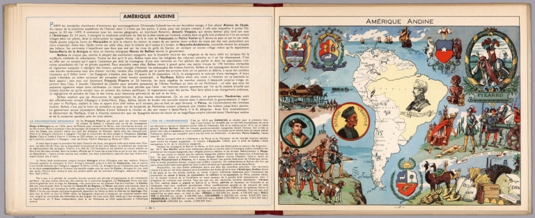
(Text Page with Map) Amerique Andine.
List No
7966.021
Note
Text and corresponding map with lavish vignettes of historic events, activities, crops, modes of transportation, structures, etc.
Author
von Sydow, E.
Full Title
35. Sued-Amerika. Westindien und die Nordkueste von Sued-Amerika. (South America, West Indies).
List No
9028.043
Author
Apgar, E.A.; Apgar, A.C.
Full Title
(Text Page and Map) Map of South America. Map of the Europe.
List No
9645.008
Note
Instructive text. Map tinted in pale pastels; also with bold red geometric figures.
1-96 of 96
|
![[North and South America.]](https://www.davidrumsey.com/rumsey/Size2/RUMSEY~8~1/213/14489044.jpg)
![[South America.]](https://www.davidrumsey.com/rumsey/Size2/RUMSEY~8~1/213/14489045.jpg)


![[Übersichtskarte].](https://www.davidrumsey.com/rumsey/Size2/RUMSEY~8~1/199/14401106.jpg)