|
Author
Giraud, Eugénie
Full Title
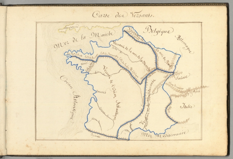
Carte des vessants.
List No
14321.011
Note
Manuscript map of France in ink and watercolor. Title translates to: Map of vessants. Shows international boundary, topography, drainage and coastline. Features major physical divisions based upon mountain ranges. Relief shown with hachures. Map is 17 x 23 cm, on sheet 21 x 31 cm. Accompanied by descriptive text on facing page. Third map appearing in the first part of atlas, France : Ses montagnes -- Ses eaux [= France : Its mountains -- Its waters].
Author
Giraud, Eugénie
Full Title
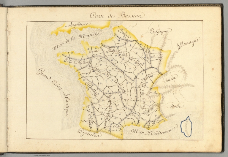
Carte des bassina.
List No
14321.013
Note
Manuscript map of France ink and watercolor. Title translates to: Map of bassins. Shows international boundary, topography, drainage and coastline. Features France's major basins formed by rivers, such as the Rhine and Seine. Relief shown with hachures. Map is 18 x 26 cm, on sheet 21 x 31 cm. Accompanied by descriptive text on facing page. Fourth map appearing in the first part of atlas, France : Ses montagnes -- Ses eaux [= France : Its mountains -- Its waters].
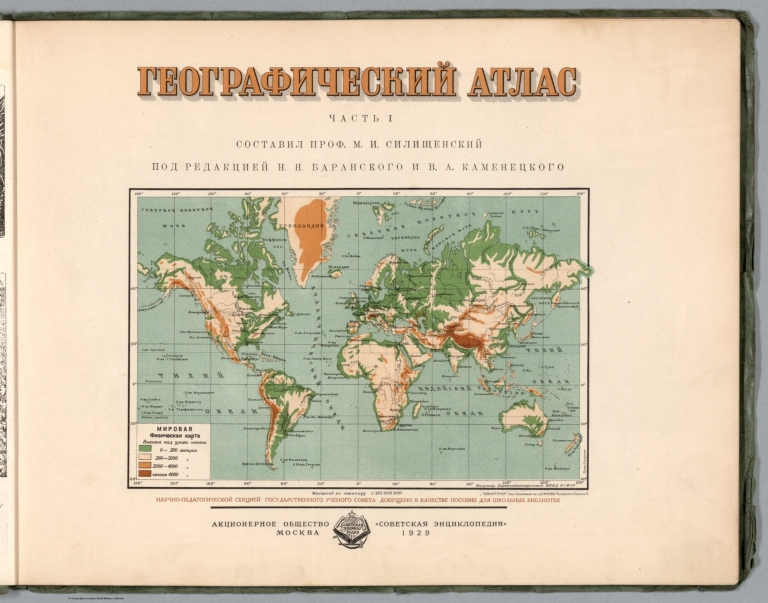
Silishchensky, Mitrofan Ivanovich 1878 -... Title Page: Geograficheskiy atlas Chast ... 1902 13461.014 Related Author
Silishchensky, Mitrofan Ivanovich 1878 - 1944
Full Title
(Title Page to) Geograficheskiy atlas Chast 1. Sostavil Prof. M. I. Silishchenskiy pod redaktsiyey N. N. Baranskogo i V. A. Kamenetskogo. Aktsionernoye obshchestvo "Sovetskaya entsiklopediya" Moskva, 1929.
List No
13461.014
Note
Second title page with physical map of the world.
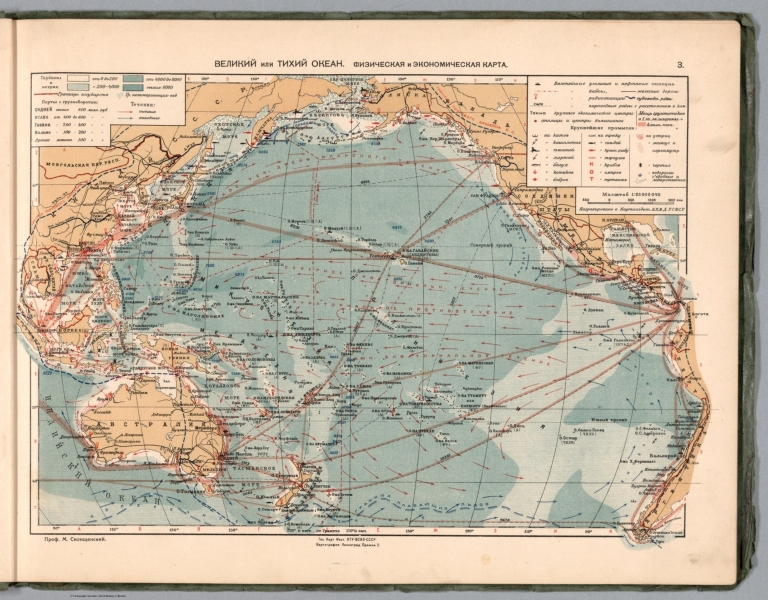
Silishchensky, Mitrofan Ivanovich 1878 -... 3. Velikiy Tikhiy Okean. Fizicheskaya i ... 1902 13461.016 Related Author
Silishchensky, Mitrofan Ivanovich 1878 - 1944
Full Title
Velikiy Tikhiy Okean. Fizicheskaya i ekonomicheskaya karta. Prof. M. I. Silishchenskiy. Gos. Kart Inst. NTU-VSNKH-SSR. Kartograiya Leningrad. (to accompany) Geograficheskiy atlas Chast 1.
List No
13461.016
Note
Physical and economical map of Pacific Ocean. Includes legend and table to map symbols. Depth shown by bathymetric tints, isolines and soundings.
Silishchensky, Mitrofan Ivanovich 1878 -... 4. Indiyskiy Okean. Ekonomicheskaya i Fi... 1902 13461.017 Related Author
Silishchensky, Mitrofan Ivanovich 1878 - 1944
Full Title
Indiyskiy Okean. Ekonomicheskaya i Fizicheskaya karta. Prof. M. I. Silishchenskiy. Gos. Kartogr. Institut NTU-VSNKH-SSR. Kartografiya Leningrad. (to accompany) Geograficheskiy atlas Chast 1.
List No
13461.017
Note
Physical and economical map of Indian Ocean. Includes profile of India ocean. Includes legend and table to map symbols.
Author
Abdulqader, M.
Full Title
Eawarid tabeia ... kharita = Map of natural geographical features. (to accompany) Küçük Coğrafya = (School atlas of geography). ikinci kisim. Murtabi M. Abdulqader. 1325 (1907).
List No
13530.006
Note
Color map. Showing geographical landscape in the form of mountains, rivers, valleys, canyon, lake, sea, island, peninsula, lagoon, etc.
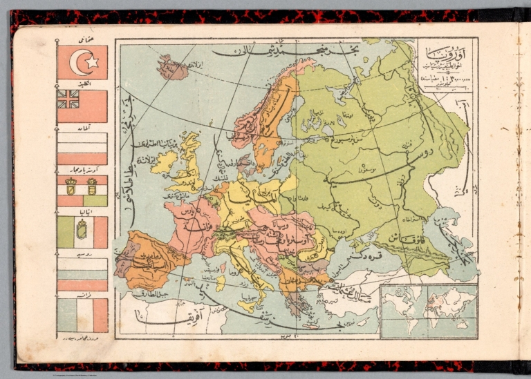
Author
Abdulqader, M.
Full Title
Avrupa : 'ahwal tabia ve siyasi = Europe : Physical and political conditions. (to accompany) Küçük Coğrafya = (School atlas of geography). ikinci kisim. Murtabi M. Abdulqader. 1325 (1907).
List No
13530.009
Note
Color political and physical map of Europe, with inset of location map. Shows political boundaries, major cities , capitals, rivers and mountains. Relief shown by hachures. Includes flags of various European counties.
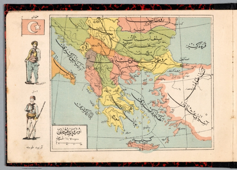
Author
Abdulqader, M.
Full Title
Avrupa İ Osmanî = European Dominions of the Ottomans. (to accompany) Küçük Coğrafya = (School atlas of geography). ikinci kisim. Murtabi M. Abdulqader. 1325 (1907).
List No
13530.011
Note
Color map of Ottoman Empire or Turkey in Europe. Shows political boundaries, major cities, rivers and mountains. Relief shown by hachures. Includes vignettes illustration of traditional costumes and Turkish flag.
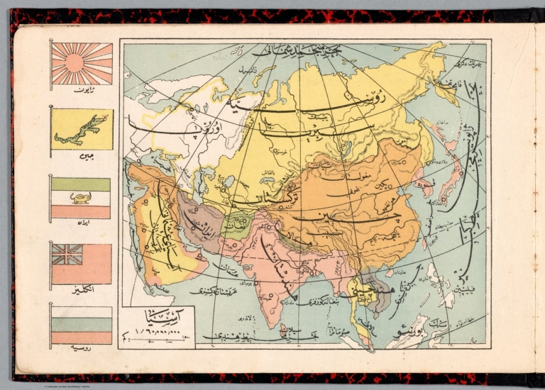
Author
Abdulqader, M.
Full Title
Asya = Asia. (to accompany) Küçük Coğrafya = (School atlas of geography). ikinci kisim. Murtabi M. Abdulqader. 1325 (1907).
List No
13530.013
Note
Color map of Asia Shows political boundaries, major cities, rivers and mountains. Relief shown by hachures. Includes vignettes of flags of various Asian countries.
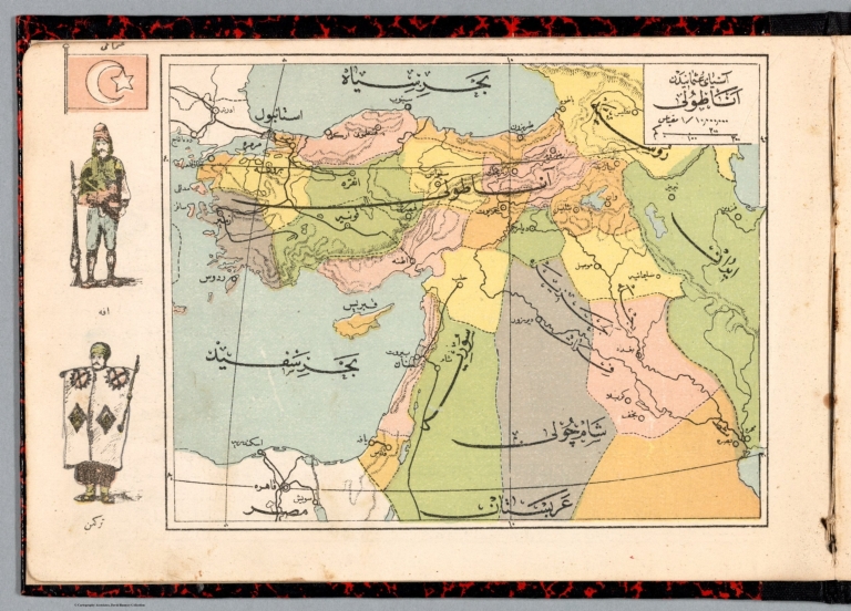
Author
Abdulqader, M.
Full Title
Asya i Osmanî : Anatuli = Ottoman Dominions in Asia : Anatoli. (to accompany) Küçük Coğrafya = (School atlas of geography). ikinci kisim. Murtabi M. Abdulqader. 1325 (1907).
List No
13530.015
Note
Color map of Ottoman Empire in Asia or Asia Minor. Shows political boundaries, major cities, rivers and mountains. Relief shown by hachures. Includes vignettes illustration of traditional costumes and Turkish flag.
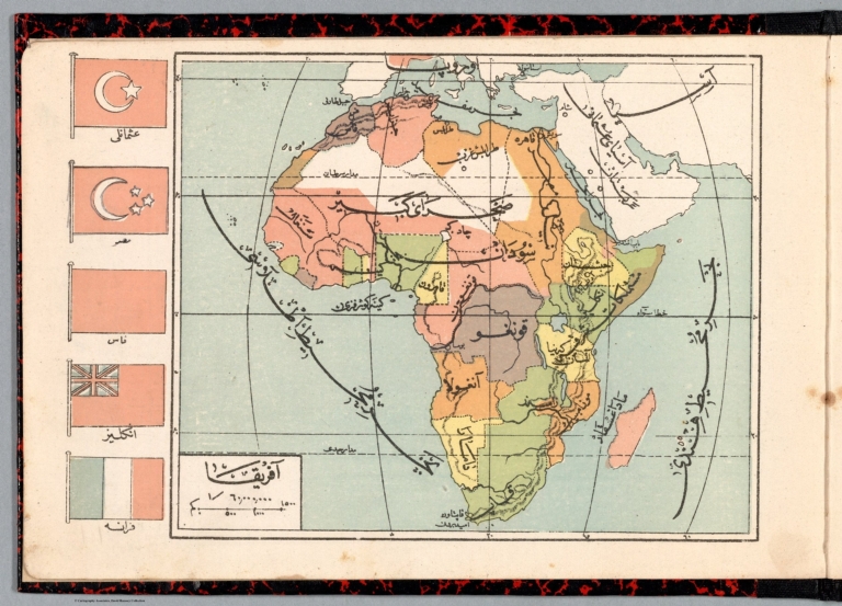
Author
Abdulqader, M.
Full Title
Afrika = Africa. (to accompany) Küçük Coğrafya = (School atlas of geography). ikinci kisim. Murtabi M. Abdulqader. 1325 (1907).
List No
13530.017
Note
Color map of Africa. Shows political boundaries, major cities, rivers and mountains. Relief shown by hachures. Includes vignettes of flags of various African countries.
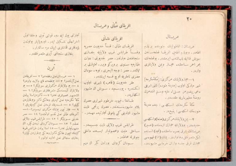
Author
Abdulqader, M.
Full Title
(Text Page to) Afrika-i Osmanî.ve Arabistan = Ottoman Empire in Africa and Arabia. (to accompany) Küçük Coğrafya = (School atlas of geography). ikinci kisim. Murtabi M. Abdulqader. 1325 (1907).
List No
13530.018
Note
Descriptive text to Ottoman Empire in Africa and Arabia.
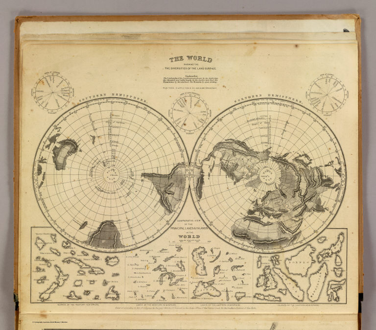
Author
Cornell, S. S. (Sarah S.)
Full Title
The World showing the diversities of the land surface. (with) Comparative view of the principal lakes & islands in the World. Entered ... 1855, by S.S. Cornell ... Southern District of New York. New York: D. Appleton & Co., 443 & 445 Broadway, (1864)
List No
0197.002
Note
Engraved map. Hand colored. Relief shown by hachures. Contents: Northern Hemisphere -- Southern Hemisphere. Comparative view maps have titles: Islands of the Western Hemisphere -- Lakes of the Western Hemisphere -- Lakes of the Eastern Hemisphere -- Islands of the Eastern Hemisphere. Includes 3 world time charts from London, San Francisco and Sydney.
Author
Anonymous
Full Title
Kunst und Technik: Mitteleuropa, per Computer farbverfremdet (Art and Technology: Central Europe, by computer color-alienated). Micro Computer Welt, Die prackische Anwendung Kleiner Computer (Microcomputer World, The practical use Small Computer).
List No
12111.000
Author
[Diercke, Carl, 1842-1913, Gaebler, Eduard, 1842-1911]
Full Title
S10. Asien. Physikalische.
List No
12198.014
Author
[Diercke, Carl, 1842-1913, Gaebler, Eduard, 1842-1911]
Full Title
S14. Palaestina.
List No
12198.018
Author
[Diercke, Carl, 1842-1913, Gaebler, Eduard, 1842-1911]
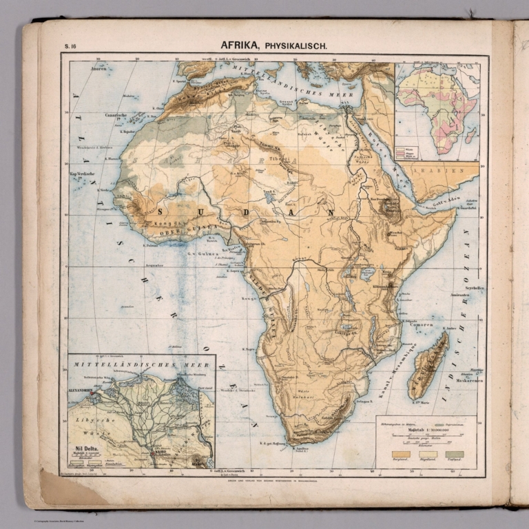
Full Title
S16. Afrika, Physikalisch.
List No
12198.020
Author
[Diercke, Carl, 1842-1913, Gaebler, Eduard, 1842-1911]
Full Title
S18. Nord-Amerika, Physikalisch.
List No
12198.022
Author
[Diercke, Carl, 1842-1913, Gaebler, Eduard, 1842-1911]
Full Title
S22. Sued-America, Physikalisch.
List No
12198.026
Author
[Diercke, Carl, 1842-1913, Gaebler, Eduard, 1842-1911]
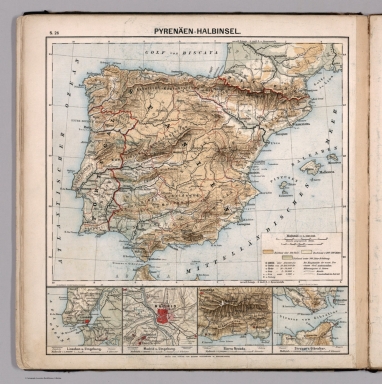
Full Title
S26. Pyrenaeen-Halbinsel.
List No
12198.030
Author
[Diercke, Carl, 1842-1913, Gaebler, Eduard, 1842-1911]
Full Title
S27. Frankreich.
List No
12198.031
Author
[Diercke, Carl, 1842-1913, Gaebler, Eduard, 1842-1911]
Full Title
S30. Britische Inseln.
List No
12198.034
Author
[Diercke, Carl, 1842-1913, Gaebler, Eduard, 1842-1911]
Full Title
S32. Russland.
List No
12198.036
Diercke, Carl, 1842-1913; Gaebler, Eduar... S34. Oesterreich - Ungarn, Physikalisch. 1883 12198.038 Related Author
[Diercke, Carl, 1842-1913, Gaebler, Eduard, 1842-1911]
Full Title
S34. Oesterreich - Ungarn, Physikalisch.
List No
12198.038
Author
[Diercke, Carl, 1842-1913, Gaebler, Eduard, 1842-1911]
Full Title
S36. Schweiz, Physikalisch.
List No
12198.040
Author
[Diercke, Carl, 1842-1913, Gaebler, Eduard, 1842-1911]
Full Title
S37. Alpengebiet.
List No
12198.041
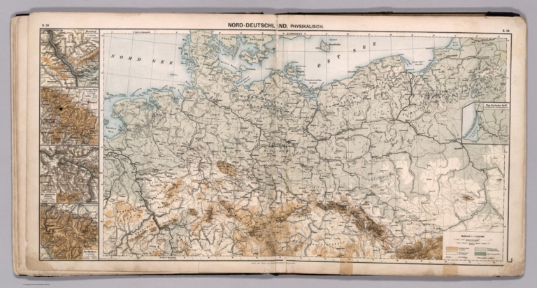
Diercke, Carl, 1842-1913; Gaebler, Eduar... S38-S39. Nord-Deutschland, Physikalisch. 1883 12198.042 Related Author
[Diercke, Carl, 1842-1913, Gaebler, Eduard, 1842-1911]
Full Title
S38-S39. Nord-Deutschland, Physikalisch.
List No
12198.042
Diercke, Carl, 1842-1913; Gaebler, Eduar... S40. Sued-Deutschland, Physikalisch. 1883 12198.043 Related Author
[Diercke, Carl, 1842-1913, Gaebler, Eduard, 1842-1911]
Full Title
S40. Sued-Deutschland, Physikalisch.
List No
12198.043
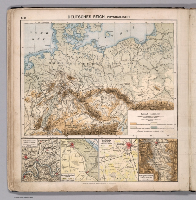
Diercke, Carl, 1842-1913; Gaebler, Eduar... S44. Deutsches Reich, Physikalisch. 1883 12198.046 Related Author
[Diercke, Carl, 1842-1913, Gaebler, Eduard, 1842-1911]
Full Title
S44. Deutsches Reich, Physikalisch.
List No
12198.046
Author
Woodbridge, William C.
Full Title
(Covers to) Modern Atlas, Physical, Political And Statistical; Exhibiting On Separate Maps, The Physical And Political Characteristics Of Countries, The Prevailing Religions, Forms Of Government And Degrees Of Civilization, The Climates And Productions Of The Earth, And The Comparative Size Of Countries, Towns, Rivers And Mountains; Accompanied By Geographical And Statistical Tables. By William C. Woodbridge ... Entered ... 1843, by W.C. Woodbridge ... Massachusetts. Hartford. Published By Belknap And Hamersley.
List No
1229.001
Note
Physical maps and Political maps. Maps by J.M. Atwood, W. Williams, C. Pelton. Maps are without color or hand painted in full and outline color. Covers are heavy brown paper printed with "School Atlas, To Accompany The Modern School Geography, By William C. Woodbridge ... Hartford: Published By Belknap & Hamersley. Entered ... 1843, by William C. Woodbridge ... Massachusetts. Case, Tiffany & Co. Printers, Hartford, Conn."
Author
Woodbridge, William C.
Full Title
(Title Page to) Modern Atlas, Physical, Political And Statistical; Exhibiting On Separate Maps, The Physical And Political Characteristics Of Countries, The Prevailing Religions, Forms Of Government And Degrees Of Civilization, The Climates And Productions Of The Earth, And The Comparative Size Of Countries, Towns, Rivers And Mountains; Accompanied By Geographical And Statistical Tables. By William C. Woodbridge ... Entered ... 1843, by W.C. Woodbridge ... Massachusetts. Hartford. Published By Belknap And Hamersley.
List No
1229.002
Note
Physical maps and Political maps. Maps by J.M. Atwood, W. Williams, C. Pelton. Maps are without color or hand painted in full and outline color. Covers are heavy brown paper printed with "School Atlas, To Accompany The Modern School Geography, By William C. Woodbridge ... Hartford: Published By Belknap & Hamersley. Entered ... 1843, by William C. Woodbridge ... Massachusetts. Case, Tiffany & Co. Printers, Hartford, Conn."
Author
Woodbridge, William C.
Full Title
(Statistical Table to) Geographical And Statistical Tables. Mountains in order of their height. Rivers in the order of their length. Lakes in order of their size. Principal canals of the World. United States and Canada. Eastern Continent. (to accompany) Modern Atlas, Physical, Political And Statistical; Exhibiting On Separate Maps, The Physical And Political Characteristics Of Countries, The Prevailing Religions, Forms Of Government And Degrees Of Civilization, The Climates And Productions Of The Earth, And The Comparative Size Of Countries, Towns, Rivers And Mountains. By William C. Woodbridge ... Entered ... 1843, by W.C. Woodbridge ... Massachusetts. Hartford. Published By Belknap And Hamersley.
List No
1229.003
Note
Geographical and Statistical Tables. By William C. Woodbridge. Covers are heavy brown paper printed with "School Atlas, To Accompany The Modern School Geography, By William C. Woodbridge ... Hartford: Published By Belknap & Hamersley. Entered ... 1843, by William C. Woodbridge ... Massachusetts. Case, Tiffany & Co. Printers, Hartford, Conn."
Author
Woodbridge, William C.
Full Title
(Statistical Tables to) Tables Of The Extent And Population Of Countries. Table Of Principal Cities Of The World In Order Of Their Populations. (to accompany) Modern Atlas, Physical, Political And Statistical; Exhibiting On Separate Maps, The Physical And Political Characteristics Of Countries, The Prevailing Religions, Forms Of Government And Degrees Of Civilization, The Climates And Productions Of The Earth, And The Comparative Size Of Countries, Towns, Rivers And Mountains. By William C. Woodbridge ... Entered ... 1843, by W.C. Woodbridge ... Massachusetts. Hartford. Published By Belknap And Hamersley.
List No
1229.004
Note
Geographical and Statistical Tables. By William C. Woodbridge. Covers are heavy brown paper printed with "School Atlas, To Accompany The Modern School Geography, By William C. Woodbridge ... Hartford: Published By Belknap & Hamersley. Entered ... 1843, by William C. Woodbridge ... Massachusetts. Case, Tiffany & Co. Printers, Hartford, Conn."
Author
Woodbridge, William C.
Full Title
(Statistical Tables to) Tables Of The Population Of The United States. (to accompany) Modern Atlas, Physical, Political And Statistical; Exhibiting On Separate Maps, The Physical And Political Characteristics Of Countries, The Prevailing Religions, Forms Of Government And Degrees Of Civilization, The Climates And Productions Of The Earth, And The Comparative Size Of Countries, Towns, Rivers And Mountains. By William C. Woodbridge ... Entered ... 1843, by W.C. Woodbridge ... Massachusetts. Hartford. Published By Belknap And Hamersley.
List No
1229.005
Note
Table includes the products of agriculture in the United States in 1842. By William C. Woodbridge. Covers are heavy brown paper printed with "School Atlas, To Accompany The Modern School Geography, By William C. Woodbridge ... Hartford: Published By Belknap & Hamersley. Entered ... 1843, by William C. Woodbridge ... Massachusetts. Case, Tiffany & Co. Printers, Hartford, Conn."
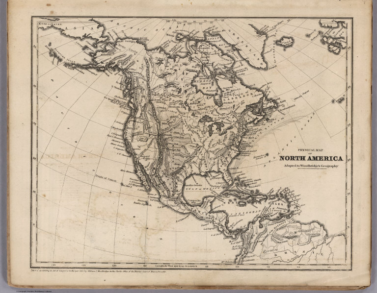
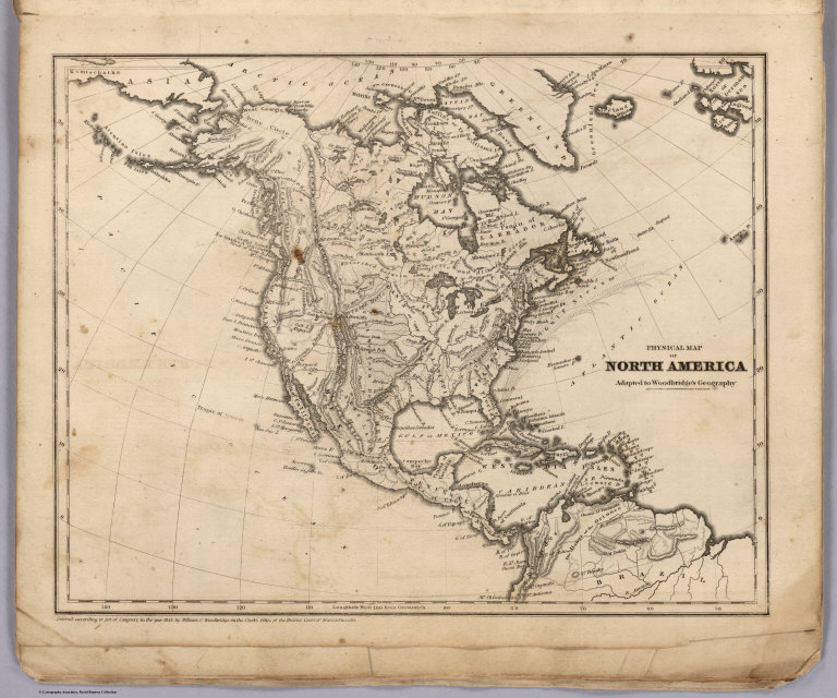
Author
Woodbridge, William C.
Full Title
Physical Map Of North America. Adapted To Woodbridge's Geography. Entered ... 1843, by W.C. Woodbridge ... Massachusetts. Hartford. Published By Wm. Jas. Hamersley. (to accompany) Modern Atlas, Physical, Political And Statistical; Exhibiting On Separate Maps ...
List No
1229.010
Note
Map showing the rivers, mountains, lakes, coastal cities and islands. Covers are heavy brown paper printed with "School Atlas, To Accompany The Modern School Geography, By William C. Woodbridge ... Hartford: Published By Belknap & Hamersley. Entered ... 1843, by William C. Woodbridge ... Massachusetts. Case, Tiffany & Co. Printers, Hartford, Conn." prime meridian is Greenwich. Relief shown by hachures. The source of scale is the "Political Map of North America."
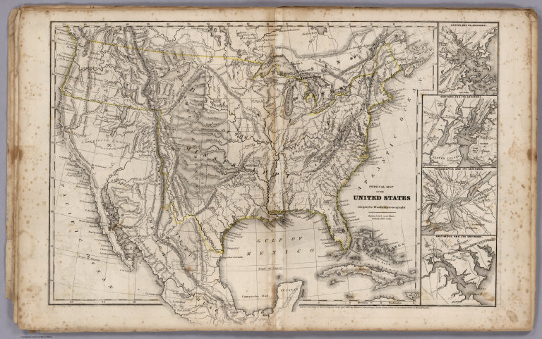
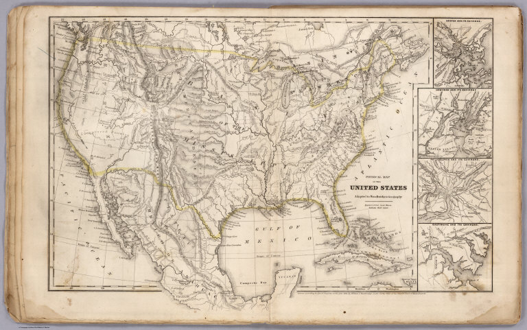
Author
Woodbridge, William C.
Full Title
Physical Map Of The United States. Adapted To Woodbridge's Geography. Figures 1. 2, 3, 4., near Rivers Indicated their Rank. Entered ... 1843, by W.C. Woodbridge ... Massachusetts. Hartford. Published By Wm. Jas. Hamersley. (to accompany) Modern Atlas, Physical, Political And Statistical; Exhibiting On Separate Maps ... Includes 4 inset maps.
List No
1229.011
Note
Map showing the rivers, mountains, lakes, coastal cities and islands. Covers are heavy brown paper printed with "School Atlas, To Accompany The Modern School Geography, By William C. Woodbridge ... Hartford: Published By Belknap & Hamersley. Entered ... 1843, by William C. Woodbridge ... Massachusetts. Case, Tiffany & Co. Printers, Hartford, Conn." prime meridian is Washington D.C. Relief shown by hachures.
Author
Woodbridge, William C.
Full Title
Physical & Political Map Of The N. Eastern States. Adapted To Woodbridge's Geography. Drawn and Engrd. by Story & Atwood. N. York. Entered ... 1843, by W.C. Woodbridge ... Massachusetts. Hartford. Published By Wm. Jas. Hamersley. (to accompany) Modern Atlas, Physical, Political And Statistical; Exhibiting On Separate Maps ...
List No
1229.013
Note
Full color color. Includes References and Explanations showing Cities, Inhabitants, Small and Large towns, Universities or Colleges, Capitals, Canals and Railways. Covers are heavy brown paper printed with "School Atlas, To Accompany The Modern School Geography, By William C. Woodbridge ... Hartford: Published By Belknap & Hamersley. Entered ... 1843, by William C. Woodbridge ... Massachusetts. Case, Tiffany & Co. Printers, Hartford, Conn." Prime meridians are Greenwich and Washington D.C. Relief shown by hachures.
Author
Woodbridge, William C.
Full Title
Physical Map Of Europe. Adapted To Woodbridge's Geography. Entered ... 1843, by W.C. Woodbridge ... Massachusetts. Hartford. Published By Wm. Jas. Hamersley. (to accompany) Modern Atlas, Physical, Political And Statistical; Exhibiting On Separate Maps ...
List No
1229.018
Note
Relief shown by hachures. Prime meridian is Greenwich. Covers are heavy brown paper printed with "School Atlas, To Accompany The Modern School Geography, By William C. Woodbridge ... Hartford: Published By Belknap & Hamersley. Entered ... 1843, by William C. Woodbridge ... Massachusetts. Case, Tiffany & Co. Printers, Hartford, Conn." The source of scale is the Political map of Europe.
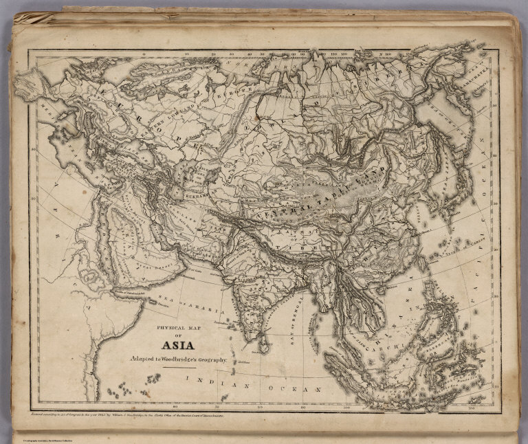
Author
Woodbridge, William C.
Full Title
Physical Map Of Asia. Adapted To Woodbridge's Geography. Entered ... 1843, by W.C. Woodbridge ... Massachusetts. Hartford. Published By Wm. Jas. Hamersley. (to accompany) Modern Atlas, Physical, Political And Statistical; Exhibiting On Separate Maps ...
List No
1229.022
Note
Relief shown by hachures. Covers are heavy brown paper printed with "School Atlas, To Accompany The Modern School Geography, By William C. Woodbridge ... Hartford: Published By Belknap & Hamersley. Entered ... 1843, by William C. Woodbridge ... Massachusetts. Case, Tiffany & Co. Printers, Hartford, Conn." The source of scale is the Political map of Asia.
Author
Woodbridge, William C.
Full Title
(Covers to) Modern Atlas, Physical, Political And Statistical; Exhibiting On Separate Maps, The Physical And Political Characteristics Of Countries, The Prevailing Religions, Forms Of Government And Degrees Of Civilization, The Climates And Productions Of The Earth, And The Comparative Size Of Countries, Towns, Rivers And Mountains; Accompanied By Geographical And Statistical Tables. By William C. Woodbridge ... Entered .. 1843, by W.C. Woodbridge ... Massachusetts. Hartford. Published By Wm. Jas. Hamersley.
List No
1231.001
Note
Physical maps and Political maps. Maps are with and without color. Covers are heavy brown paper printed with "School Atlas, To Accompany The Modern School Geography, By William C. Woodbridge ... Hartford: Published By Wm. Jas. Hamersley. Entered ... 1843, by William C. Woodbridge ... Massachusetts. Case, Tiffany & Co. Printers, Hartford, Conn."
Author
Woodbridge, William C.
Full Title
(Title Page to) Modern Atlas, Physical, Political And Statistical; Exhibiting On Separate Maps, The Physical And Political Characteristics Of Countries, The Prevailing Religions, Forms Of Government And Degrees Of Civilization, The Climates And Productions Of The Earth, And The Comparative Size Of Countries, Towns, Rivers And Mountains; Accompanied By Geographical And Statistical Tables. By William C. Woodbridge ... Entered .. 1843, by W.C. Woodbridge ... Massachusetts. Hartford. Published By Wm. Jas. Hamersley.
List No
1231.002
Note
Physical maps and Political maps. Maps are with and without color. Covers are heavy brown paper printed with "School Atlas, To Accompany The Modern School Geography, By William C. Woodbridge ... Hartford: Published By Wm. Jas. Hamersley. Entered ... 1843, by William C. Woodbridge ... Massachusetts. Case, Tiffany & Co. Printers, Hartford, Conn."
Author
Woodbridge, William C.
Full Title
(Statistical Tables to) Table Of The Population Of The United States. Entered .. 1843, by W.C. Woodbridge ... Massachusetts. Hartford. Published By Wm. Jas. Hamersley.
List No
1231.005
Note
Table includes the products of agriculture in the United States in 1842. Physical maps and Political maps. Maps are with and without color. Covers are heavy brown paper printed with "School Atlas, To Accompany The Modern School Geography, By William C. Woodbridge ... Hartford: Published By Wm. Jas. Hamersley. Entered ... 1843, by William C. Woodbridge ... Massachusetts. Case, Tiffany & Co. Printers, Hartford, Conn."
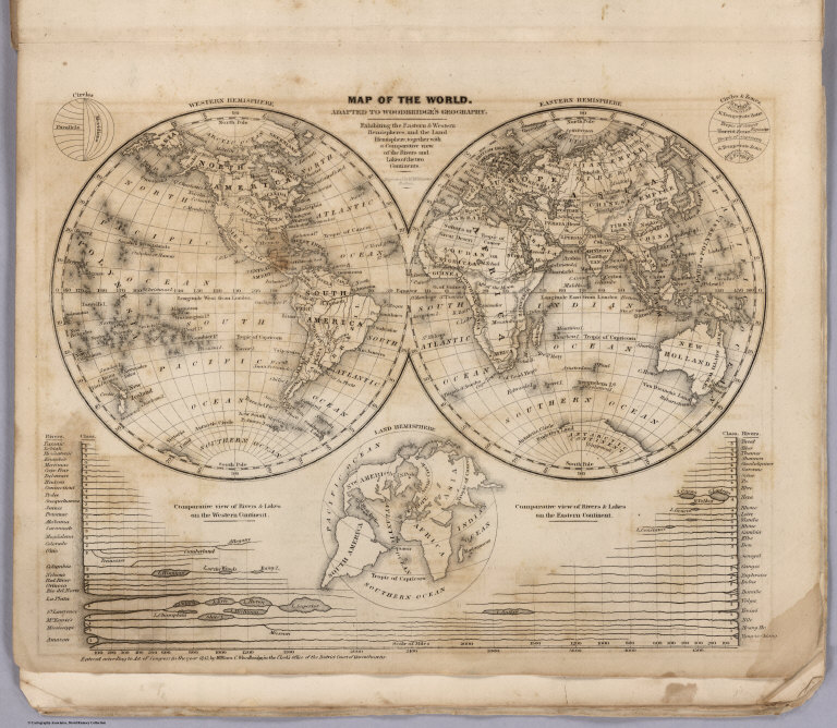
Author
Woodbridge, William C.
Full Title
Map Of The World. Adapted To Woodbridge's Geography. Exhibiting The Eastern & Western Hemisphere, And the Land Hemisphere, Together With Comparative View Of the Rivers And Lake of the Two Continents. Includes 2 insets and Comparative View of Rivers & Lakes on The Eastern and Western Continents. Entered ... 1845, by W.C. Woodbridge ... Massachusetts. Hartford. Published By Wm. Jas. Hamersley.
List No
1231.006
Note
Physical maps and Political maps. Map printed without color. Covers are heavy brown paper printed with "School Atlas, To Accompany The Modern School Geography, By William C. Woodbridge ... Hartford: Published By Wm. Jas. Hamersley. Entered ... 1843, by William C. Woodbridge ... Massachusetts. Case, Tiffany & Co. Printers, Hartford, Conn."
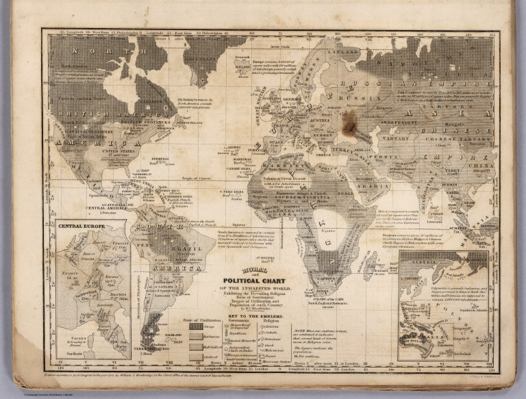
Author
Woodbridge, William C.
Full Title
Moral And Political Chart Of The Inhabited World. Exhibiting The Prevailing Religion, Form Of Government, Degree Of Civilization, and Population of Each Country. By W.C. Woodbridge. (Engraved by) C. Pelton & W. Williams. Entered .. . 1845, by W.C. Woodbridge ... Massachusetts. Hartford. Published By Wm. Jas. Hamersley. (inset map) Central Europe. (inset map) Untitled map of Polynesia.
List No
1231.007
Note
Map printed without color. Covers are heavy brown paper printed with "School Atlas, To Accompany The Modern School Geography, By William C. Woodbridge ... Hartford: Published By Wm. Jas. Hamersley. Entered ... 1843, by William C. Woodbridge ... Massachusetts. Case, Tiffany & Co. Printers, Hartford, Conn." Includes: Key to the Emblems. Prime meridians are Philadelphia and London.
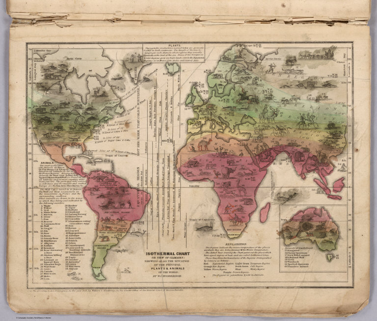
Author
Woodbridge, William C.
Full Title
Isothermal Chart Or View Of Climates: Showing also The Situations Of The Principal Plants & Animals Of The World. By W.C. Woodbridge. Entered .. . 1843, by W.C. Woodbridge ... Massachusetts. Hartford. Published By Wm. Jas. Hamersley. (inset map) Animals of New Holland.
List No
1231.008
Note
The figures on the map indicate the means of temperature of the places... The dotted lines crossing the chart point out to places which have equal degree of heat are called Isothermal Lines. These lines... distinguished by color on the map. The figure in parenthesis (1) refer to animals. Full color map. Covers are heavy brown paper printed with "School Atlas, To Accompany The Modern School Geography, By William C. Woodbridge ... Hartford: Published By Wm. Jas. Hamersley. Entered ... 1843, by William C. Woodbridge ... Massachusetts. Case, Tiffany & Co. Printers, Hartford, Conn."
Author
Woodbridge, William C.
Full Title
Physical Map Of North America. Adapted To Woodbridge's Geography. Entered .. . 1843, by W.C. Woodbridge ... Massachusetts. Hartford. Published By Wm. Jas. Hamersley.
List No
1231.009
Note
Map printed without color. Covers are heavy brown paper printed with "School Atlas, To Accompany The Modern School Geography, By William C. Woodbridge ... Hartford: Published By Wm. Jas. Hamersley. Entered ... 1843, by William C. Woodbridge ... Massachusetts. Case, Tiffany & Co. Printers, Hartford, Conn." Prime meridian is Greenwich. Relief shown by hachures. The source of scale is the "Political Map of North America."
Author
Woodbridge, William C.
Full Title
Physical Map Of The United States. Adapted To Woodbridge's Geography. Figures 1, 2, 3, 4, Near Rivers, Indicate Their Ranks. Entered .. . 1843, by W.C. Woodbridge ... Massachusetts. Hartford. Published By Wm. Jas. Hamersley. Includes 5 inset maps.
List No
1231.011
Note
Map printed without color. Covers are heavy brown paper printed with "School Atlas, To Accompany The Modern School Geography, By William C. Woodbridge ... Hartford: Published By Wm. Jas. Hamersley. Entered ... 1843, by William C. Woodbridge ... Massachusetts. Case, Tiffany & Co. Printers, Hartford, Conn." Prime meridian is Washington D.C. Relief shown by hachures.
Author
Woodbridge, William C.
Full Title
Physical And Political Map Of The N. Eastern States. Adapted To Woodbridge's Geography. Drawn & Engd. by Story & Atwood. N. York. Entered .. . 1843, by W.C. Woodbridge ... Massachusetts. Hartford. Published By Wm. Jas. Hamersley.
List No
1231.013
Note
Full color map. Includes References and Explanations, showing Cities, Inhabitants, Universities or Colleges, Canals and Railways. Covers are heavy brown paper printed with "School Atlas, To Accompany The Modern School Geography, By William C. Woodbridge ... Hartford: Published By Wm. Jas. Hamersley. Entered ... 1843, by William C. Woodbridge ... Massachusetts. Case, Tiffany & Co. Printers, Hartford, Conn." Prime meridians are Greenwich and Washington D.C. Relief shown by hachures.
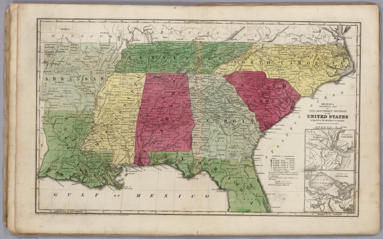
Author
Woodbridge, William C.
Full Title
Physical & Political Map Of The Southern Division Of the United States. Adapted To Woodbridge's Geography. Entered .. . 1843, by W.C. Woodbridge ... Massachusetts. Hartford. Published By Wm. Jas. Hamersley. (inset map) Vicinity of Charleston. (inset map) Vicinity of New Orleans.
List No
1231.015
Note
Full color map. Includes References and Explanations, showing Cities, Inhabitants, Universities or Colleges, Canals and Railways. Covers are heavy brown paper printed with "School Atlas, To Accompany The Modern School Geography, By William C. Woodbridge ... Hartford: Published By Wm. Jas. Hamersley. Entered ... 1843, by William C. Woodbridge ... Massachusetts. Case, Tiffany & Co. Printers, Hartford, Conn." Prime meridians are Greenwich and Washington D.C. Relief shown by hachures.
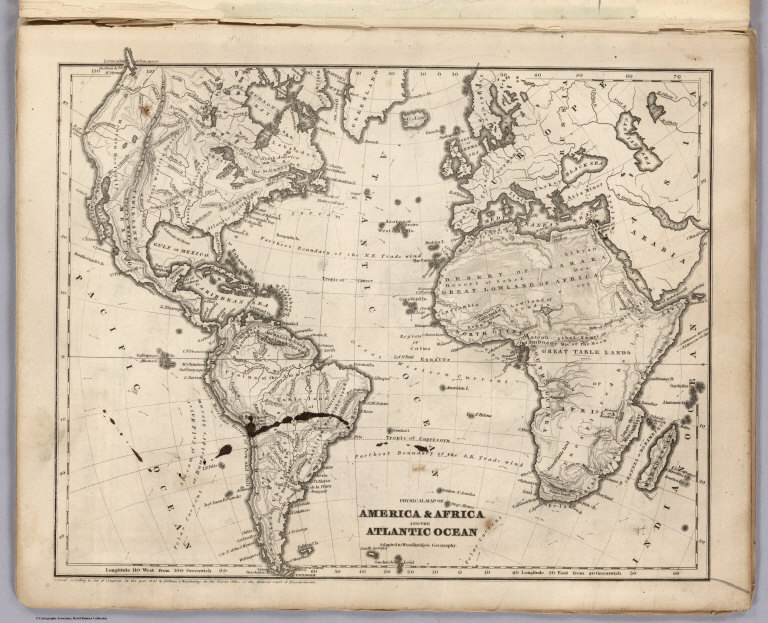
Author
Woodbridge, William C.
Full Title
Physical Map Of America & Africa And the Atlantic Ocean. Adapted To Woodbridge's Geography. Entered .. . 1843, by W.C. Woodbridge ... Massachusetts. Hartford. Published By Wm. Jas. Hamersley.
List No
1231.016
Note
Map printed without color. Covers are heavy brown paper printed with "School Atlas, To Accompany The Modern School Geography, By William C. Woodbridge ... Hartford: Published By Wm. Jas. Hamersley. Entered ... 1843, by William C. Woodbridge ... Massachusetts. Case, Tiffany & Co. Printers, Hartford, Conn." Prime meridian is Greenwich. Relief shown by hachures.
|