|
Author
Stanford, Edward
Full Title
The World
List No
15996.004
Note
Date estimated.
Author
Stanford, Edward
Full Title
Eastern Hemisphere
List No
15996.005
Note
Date estimated.
Author
Stanford, Edward
Full Title
Western Hemisphere
List No
15996.006
Note
Date estimated.
Author
Stanford, Edward
Full Title
England
List No
15996.008
Note
Date estimated.
Author
Stanford, Edward
Full Title
Scotland
List No
15996.009
Note
Date estimated.
Author
Stanford, Edward
Full Title
Ireland
List No
15996.010
Note
Date estimated.
Author
Stanford, Edward
Full Title
Australia
List No
15996.020
Note
Date estimated.
Author
Stanford, Edward
Full Title
New Zealand
List No
15996.021
Note
Date estimated.
Author
Logerot, A. (Auguste)
Full Title
[Map of Europe.] Ce 8 8bre 1856 ; A. Logerot.
List No
14489.003
Note
Manuscript map representing Europe. Shows select regions, mountain ranges, drainage, coastlines, and islands. Relief shown with hachure lines and shading. Indexed to indicate the names of mountain ranges. Ink, pencil, and watercolor on paper. Indexed to indicate locations such as the Tyrolean Alps and Saint-Gotthard Massif. Map is 24 x 30 cm, on sheet 24 x 32 cm.
Author
Logerot, A. (Auguste)
Full Title
[Map of Europe.] Ce 15 8bre 1856 ; A. Logerot.
List No
14489.004
Note
Manuscript map representing Europe. Shows select regions, cities, mountain ranges, drainage, coastlines, and islands. Relief shown with shading. Features watershed areas, which are differentiated by color. Indexed to indicate the names of mountains and lakes. Ink, pencil, and watercolor on paper. Map is 24 x 30 cm, on sheet 24 x 32 cm.
Author
Logerot, A. (Auguste)
Full Title
Mer Blanche. Ce 23 8bre 1856 ; A. Logerot.
List No
14489.005
Note
Manuscript map representing the White Sea. Shows select regions, cities, mountain ranges, drainage, coastlines, and islands. Relief shown with shading. Ink, pencil, and watercolor on paper. Map is 24 x 30 cm, on sheet 24 x 32 cm.
Author
Logerot, A. (Auguste)
Full Title
Rhin Suisse. Ce 18 Fevrier 1857 ; A. Logerot.
List No
14489.015
Note
Manuscript map representing the watershed of the Rhine River in Switzerland. Shows select regions, cities, mountain ranges, drainage, and bodies of water. Relief shown with shading. Ink, pencil, and watercolor on paper. Map is 22 x 28 cm, on sheet 24 x 31 cm.
Author
Logerot, A. (Auguste)
Full Title
[France.] A. Logerot.
List No
14489.021
Note
Manuscript map representing France. Shows select regions, mountain ranges, drainage, coastlines, and islands. Relief shown with shading. Ink, pencil, and watercolor on paper. Map is 23 x 29 cm, on sheet 24 x 31 cm.
Author
Logerot, A. (Auguste)
Full Title
[Armorican Massif, France.] Ce 98 Mai 1857 ; A. Logerot.
List No
14489.025
Note
Manuscript map representing the Armorican Massif in France. Shows select regions, cities, mountain ranges, drainage, coastlines, and islands. Relief shown with shading. Ink, pencil, and watercolor on paper. Map is 21 x 29 cm, on sheet 24 x 31 cm.
Author
Logerot, A. (Auguste)
Full Title
[Loire River.] A. Logerot.
List No
14489.026
Note
Manuscript map representing the Loire River basin in France. Shows select regions, cities, mountain ranges, drainage, coastlines, and islands. Relief shown with shading. Ink, pencil, and watercolor on paper. Map is 23 x 30 cm, on sheet 23 x 30 cm.
Author
Logerot, A. (Auguste)
Full Title
[Loire River.] A. Logerot.
List No
14489.027
Note
Manuscript map representing the Loire River basin in France. Shows select regions, cities, mountain ranges, drainage, coastlines, and islands. Relief shown with shading. Ink, pencil, and watercolor on paper. Map is 23 x 29 cm, on sheet 23 x 30 cm.
Author
Logerot, A. (Auguste)
Full Title
Asie mineure. A. Logerot.
List No
14489.038
Note
Manuscript map representing Asia Minor. Shows select regions, cities, mountain ranges, drainage, coastlines, and islands. Relief shown with shading. Ink, pencil, and watercolor on paper. Map is 21 x 27 cm, on sheet 24 x 31 cm.
Author
Logerot, A. (Auguste)
Full Title
Afrique. A. Logerot ; Ce 8 Janvier 1856.
List No
14489.041
Note
Manuscript map representing Africa. Shows select regions, cities, mountain ranges, deserts, drainage, coastlines, and islands. Relief shown with shading. Ink, pencil, and watercolor on paper. Map is 22 x 28 cm, on sheet 24 x 31 cm. (Page number written as “43” for page 44 in volume.)
Author
Logerot, A. (Auguste)
Full Title
Amerique du Noro. A. Logerot.
List No
14489.042
Note
Manuscript map representing North America. Shows select regions, mountain ranges, coastlines, and islands. Ink, pencil, and watercolor on paper. Map is 30 x 23 cm, on sheet 30 x 23 cm.
Author
Logerot, A. (Auguste)
Full Title
Amérique Septentrionale. A. Logerot.
List No
14489.043
Note
Manuscript map representing North America. Shows select regions, mountain ranges, drainage, bodies of water, coastlines, and islands. Relief shown with shading. Ink, pencil, and watercolor on paper. Map is 27 x 23 cm, on sheet 31 x 23 cm.
Author
Logerot, A. (Auguste)
Full Title
[North and South America.] A. Logerot.
List No
14489.044
Note
Manuscript map representing North and South America. Shows select regions, mountain ranges, drainage, bodies of water, coastlines, and islands. Relief shown with shading. Ink, pencil, and watercolor on paper. Map is 31 x 23 cm, on sheet 31 x 23 cm.
Author
Logerot, A. (Auguste)
Full Title
[South America.] A. Logerot.
List No
14489.045
Note
Manuscript map representing South America. Shows select regions, mountain ranges, drainage, coastlines, and islands. Relief shown with shading. Ink, pencil, and watercolor on paper. Map is 22 x 28 cm, on sheet 30 x 23 cm.
Author
Logerot, A. (Auguste)
Full Title
Océanie. A. Logerot.
List No
14489.046
Note
Manuscript map representing Oceania. Shows select regions, cities, mountain ranges, drainage, coastlines, and islands. Relief shown with shading. Ink, pencil, and watercolor on paper. Map is 22 x 28 cm, on sheet 24 x 30 cm.
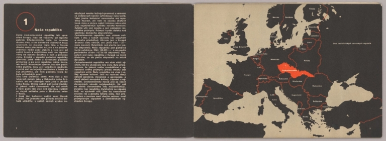
Author
[Sutnar, Ladislav, Tschinkel, Augustin]
Full Title
Naše republika (Our Country)
List No
15867.003
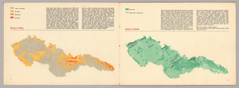
Author
[Sutnar, Ladislav, Tschinkel, Augustin]
Full Title
Hory a Feky (Mountains and Rivers) (with) Lesy a lázne (Forests and Land)
List No
15867.004
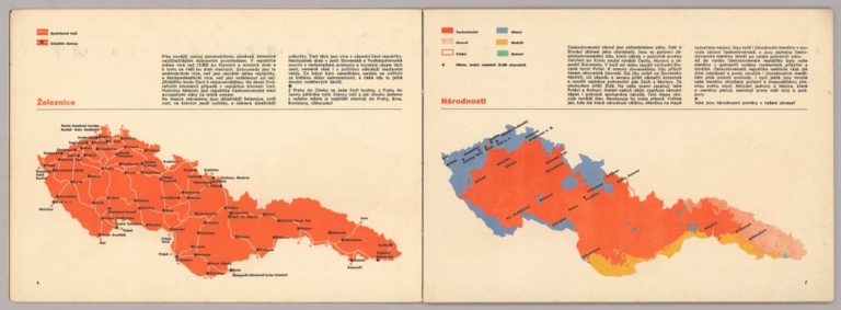
Author
[Sutnar, Ladislav, Tschinkel, Augustin]
Full Title
Železnice (Railways) (with) Národnosti (Nationalities)
List No
15867.005
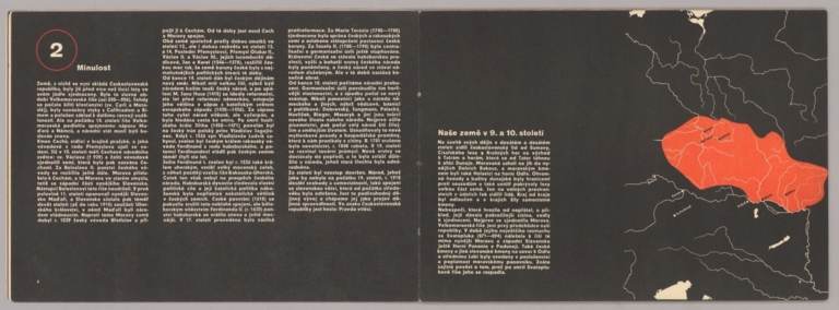
Author
[Sutnar, Ladislav, Tschinkel, Augustin]
Full Title
Minulest (The Past) (with) Naše země v 9. a 10. století (Our country in the 9th and 10th centuries)
List No
15867.006
Author
[Sutnar, Ladislav, Tschinkel, Augustin]
Full Title
Ríše Přemysla II. Otakara (The Empire of Přemysl II Otakara) (with) Ríše Václava lI. a Václava IIl. (The Empire of Wenceslas I. and Wenceslas III)
List No
15867.007
Author
[Sutnar, Ladislav, Tschinkel, Augustin]
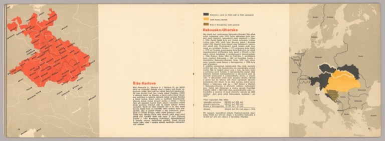
Full Title
Riše Karlova (Karlova's Empire) (with) Rakousko-Uhersko (Austria Hungary)
List No
15867.008
Author
[Sutnar, Ladislav, Tschinkel, Augustin]
Full Title
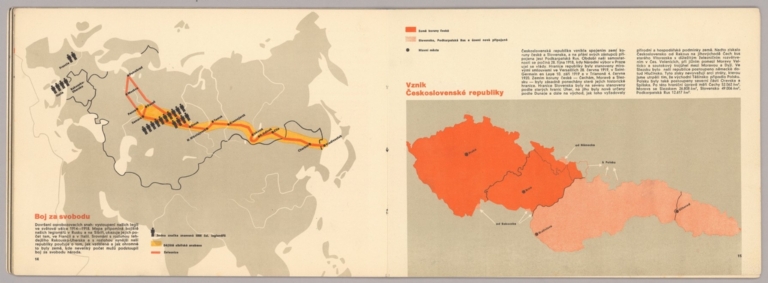
Boj za svobodu (The Fight for Freedom) (with) Vznik Československé republiky (Emergence of the Czechoslovak Republic)
List No
15867.009
Author
[Sutnar, Ladislav, Tschinkel, Augustin]
Full Title
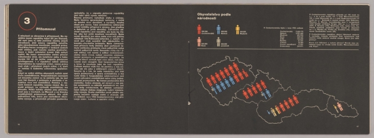
Přítomnost (Presence) (with) Obyvatelstvo podle národnosti (Population by Nationality)
List No
15867.010
Author
[Sutnar, Ladislav, Tschinkel, Augustin]
Full Title
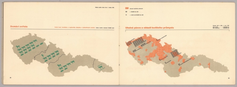
Domácí zvířata (Domestic Animals) (with) Uhelné pánve a oblasti textilního průmyslu (Coal basins and textile industry areas)
List No
15867.013
Author
[Sutnar, Ladislav, Tschinkel, Augustin]
Full Title
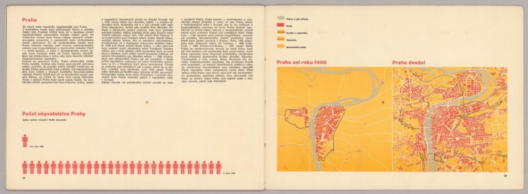
Praha (Prague) (with) Počet obyvatelstva Prahy (Population of Prague) Praha asi roku 1400 (Prague around 1400) (and) Praha dnešní (Today's Prague)
List No
15867.016
Author
[Ravenstein, August, Berlin Geographisch-Artistische Anstalt Ernst Schotte]
Full Title
Karten-Ideal zur elementaren Darstellung der topischen Verhältnisse von Wasser und Land auf dem Erdboden, nebst der Oestl. & Westl. Erdhälfte, zur Erläuterung mathemat. eintheilung u. physisch-geograph. Verhältnisse. Zeichnung u. Modell von August Ravenstein in Frankfurt a. M. Stich, Prägung, Druck u. Verlag von B. Dondorf in Frankfurt a. M.
List No
14473.003
Note
Relief map of the world, shown as the Western and Eastern Hemispheres, as well as a closer view of the Netherlands and vicinity. Shows geographical regions, topography, vegetation, bodies of water, drainage, coastlines, shoals and islands. Topography shown with raised relief. Includes latitudinal and longitudinal lines, as well as descriptive notes. Legend for map appears on title page. Colored lithograph. Map is 22 x 27 cm, within frame 24 x 28 cm. Within a series of eight maps comprising the school atlas, Plastischer Schul-Atlas.
Author
[Ravenstein, August, Berlin Geographisch-Artistische Anstalt Ernst Schotte]
Full Title
Deutschland nebst den Königreichen Holland, Belgien und der Republik Schweiz. Zeichnung u. Modell von August Ravenstein in Frankfurt a. M. Stich, Prägung, Druck u. Verlag von B. Dondorf in Frankfurt a. M.
List No
14473.004
Note
Relief map of Germany, the Netherlands, Belgium and Switzerland. Shows geographical regions, countries, cities, railways, canals, topography, vegetation, bodies of water, drainage, coastlines, shoals and islands. Topography shown with raised relief. Includes a legend, bar scale given in miles, latitudinal and longitudinal lines, as well as statistical and descriptive notes. Additional legend for map appears on title page. Colored lithograph. Map is 22 x 27 cm, within frame 24 x 28 cm. Within a series of eight maps comprising the school atlas, Plastischer Schul-Atlas.
Author
[Ravenstein, August, Berlin Geographisch-Artistische Anstalt Ernst Schotte]
Full Title
Europa. Zeichnung u. Modell von August Ravenstein in Frankfurt a. M. Stich, Prägung, Druck u. Verlag von B. Dondorf in Frankfurt a. M.
List No
14473.005
Note
Relief map of Europe. Shows geographical regions, countries, cities, railways, topography, vegetation, bodies of water, drainage, coastlines, shoals and islands. Topography shown with raised relief. Includes a legend, bar scale given in miles, latitudinal and longitudinal lines, as well as statistical and descriptive notes. Additional legend for map appears on title page. With a vignette of scenery, figures, fauna and flora. Colored lithograph. Map is 22 x 27 cm, within frame 24 x 28 cm. Within a series of eight maps comprising the school atlas, Plastischer Schul-Atlas.
Author
[Ravenstein, August, Berlin Geographisch-Artistische Anstalt Ernst Schotte]
Full Title
Asien. Zeichnung u. Modell von August Ravenstein in Frankfurt a. M. Stich, Prägung, Druck u. Verlag von B. Dondorf in Frankfurt a. M.
List No
14473.006
Note
Relief map of Asia. Shows geographical regions, countries, cities, railways, topography, vegetation, bodies of water, drainage, coastlines, shoals and islands. Topography shown with raised relief. Includes a legend, bar scale given in miles, latitudinal and longitudinal lines, as well as statistical and descriptive notes. Additional legend for map appears on title page. With an indexed vignette of scenery, indigenous figures, fauna and flora. Colored lithograph. Map is 22 x 27 cm, within frame 24 x 28 cm. Within a series of eight maps comprising the school atlas, Plastischer Schul-Atlas.
Author
[Ravenstein, August, Berlin Geographisch-Artistische Anstalt Ernst Schotte]
Full Title
Nord-u. Mittel-Amerika. Zeichnung u. Modell von August Ravenstein in Frankfurt a. M. Stich, Prägung, Druck u. Verlag von B. Dondorf in Frankfurt a. M.
List No
14473.007
Note
Relief map of North and Central America. Shows geographical regions, countries, cities, railways, topography, vegetation, bodies of water, drainage, coastlines, shoals and islands. Topography shown with raised relief. Includes a legend, bar scale given in miles, latitudinal and longitudinal lines, as well as statistical and descriptive notes. Additional legend for map appears on title page. With an indexed vignette of scenery, figures, fauna and flora. Colored lithograph. Map is 27 x 22 cm, within frame 28 x 24 cm. Within a series of eight maps comprising the school atlas, Plastischer Schul-Atlas.
Author
[Ravenstein, August, Berlin Geographisch-Artistische Anstalt Ernst Schotte]
Full Title
Südamerika. Zeichnung u. Modell von August Ravenstein in Frankfurt a. M. Stich, Prägung, Druck u. Verlag von B. Dondorf in Frankfurt a. M.
List No
14473.008
Note
Relief map of South America. Shows geographical regions, countries, cities, railways, topography, vegetation, bodies of water, drainage, coastlines, shoals and islands. Topography shown with raised relief. Includes a legend, bar scale given in miles, latitudinal and longitudinal lines, as well as statistical and descriptive notes. Additional legend for map appears on title page. With an indexed vignette of scenery, figures, fauna and flora. Colored lithograph. Map is 27 x 22 cm, within frame 28 x 24 cm. Within a series of eight maps comprising the school atlas, Plastischer Schul-Atlas.
Author
[Ravenstein, August, Berlin Geographisch-Artistische Anstalt Ernst Schotte]
Full Title
Afrika. Zeichnung u. Modell von August Ravenstein in Frankfurt a. M. Stich, Prägung, Druck u. Verlag von B. Dondorf in Frankfurt a. M.
List No
14473.009
Note
Relief map of Africa. Shows geographical regions, countries, cities, railways, topography, vegetation, bodies of water, drainage, coastlines, shoals and islands. Topography shown with raised relief. Includes a legend, bar scale given in miles, latitudinal and longitudinal lines, as well as statistical and descriptive notes. Additional legend for map appears on title page. With an indexed vignette of scenery, figures, fauna and flora. Colored lithograph. Map is 22 x 27 cm, within frame 24 x 28 cm. Within a series of eight maps comprising the school atlas, Plastischer Schul-Atlas.
Author
[Ravenstein, August, Berlin Geographisch-Artistische Anstalt Ernst Schotte]
Full Title
Australien und Polynesien. Zeichnung u. Modell von August Ravenstein in Frankfurt a. M. Stich, Prägung, Druck u. Verlag von B. Dondorf in Frankfurt a. M.
List No
14473.010
Note
Relief map of Australia and Polynesia. Shows geographical regions, countries, cities, railways, topography, vegetation, bodies of water, drainage, coastlines, shoals and islands. Topography shown with raised relief. Includes a legend, bar scale given in miles, latitudinal and longitudinal lines, as well as statistical and descriptive notes. Additional legend for map appears on title page. With an indexed vignette of scenery, figures, fauna and flora. Colored lithograph. Map is 22 x 27 cm, within frame 24 x 28 cm. Within a series of eight maps comprising the school atlas, Plastischer Schul-Atlas.
Author
Gallardo y Rionda, J.P.
Full Title
Mapa Mudo del Distrito Federal.
List No
15466.008
Note
Blank map to be filled in by students from studying the following full printed map of the same area.
Author
Gallardo y Rionda, J.P.
Full Title
Carta Geografica del Distrito Federal.
List No
15466.009
Author
Imhof, Eduard, 1895-1986
Full Title
Zentralschweiz.
List No
14401.008
Note
Map of central Switzerland, in 1969. Shows cities, railways, roads, topography, valleys, glaciers, bodies of water and drainage. Relief shown with contour lines, shading and spot heights. Includes a bar scale and scale statement. Colored lithograph. Map is 24 x 17 cm, on sheet 33 x 22 cm. Appears in section entitled Schweiz : Einzelne Landschaften [= Individual landscapes].
Author
Imhof, Eduard, 1895-1986
Full Title
Gruyères (Kt. Freiburg) -- Mürtschenstock (Kt. Glarus) : Bergformen im Kalkfels, Karrenfelder.
List No
14401.009
Note
Two maps of Switzerland, featuring the city of Gruyères in the canton of Fribourg, and Mürtschenstock, a mountain massif of the Glarus [Glarner] Alps, in the canton of Glarus, in 1969. Maps also show cities, railways, roads, topography, valleys, glaciers, bodies of water and drainage. Relief shown with contour lines, shading and spot heights. Maps include bar scales (scales differ) and scale statements. Colored lithograph. Together, maps are 29 x 17 cm, on sheet 33 x 22 cm. Maps appear in section entitled Schweiz : Einzelne Landschaften [= Individual landscapes].
Author
Imhof, Eduard, 1895-1986
Full Title
Matterhorn und Z'Muttgletscher : Kristalline Bergformen -- Rhonetal bei Sierre und Leuk : Talstufe und Sprachgrenze zwischen Ober- und Unterwallis.
List No
14401.010
Note
Two maps of Switzerland, featuring the Matterhorn mountain, the Muttgletscher glacier and the Rhône River Valley, near the cities of Sierre and Leuk, in 1969. Maps also show cities, railways, roads, topography, valleys, glaciers, bodies of water and drainage. Relief shown with contour lines, shading and spot heights. Maps include bar scales (scales differ) and scale statements. Colored lithograph. Together, maps are 29 x 17 cm, on sheet 33 x 22 cm. Maps appear in section entitled Schweiz : Einzelne Landschaften [= Individual landscapes].
Author
Imhof, Eduard, 1895-1986
Full Title
Gotthardgebiet -- Luganersee.
List No
14401.011
Note
Two maps of Switzerland, featuring the Gotthard Pass and Lake Lugano, in 1969. Maps also show cities, railways, roads, topography, valleys, glaciers, bodies of water and drainage. Relief shown with contour lines, shading and spot heights. Maps include bar scales (scales differ) and scale statements. Colored lithograph. Together, maps are 29 x 17 cm, on sheet 33 x 22 cm. Maps appear in section entitled Schweiz : Einzelne Landschaften [= Individual landscapes].
Author
Imhof, Eduard, 1895-1986
Full Title
Säntisgruppe und Appenzellerland : (Nördlicher Alpenrand).
List No
14401.012
Note
Map of Switzerland, featuring the mountain of Säntis and the Appenzell Alps, on the northern edge of the Swiss Alps, in 1969. Also shows cities, railways, roads, topography, valleys, glaciers, bodies of water and drainage. Relief shown with contour lines, shading and spot heights. Includes a bar scale and scale statement. Colored lithograph. Map is 29 x 17 cm, on sheet 33 x 22 cm. Appears in section entitled Schweiz : Einzelne Landschaften [= Individual landscapes].
Author
Imhof, Eduard, 1895-1986
Full Title
Jungfraugruppe und Aletschgletscher.
List No
14401.013
Note
Map of Switzerland, featuring the mountain of Jungfrau and the Aletsch Glacier, in 1969. Also shows cities, railways, roads, topography, valleys, glaciers, bodies of water and drainage. Relief shown with contour lines, shading and spot heights. Includes a bar scale and scale statement. Colored lithograph. Map is 29 x 17 cm, on sheet 33 x 22 cm. Appears in section entitled Schweiz : Einzelne Landschaften [= Individual landscapes].
Author
Imhof, Eduard, 1895-1986
Full Title
Oberengadin.
List No
14401.014
Note
Map of Switzerland, featuring the valley of Engadine, in 1969. Shows cities, railways, roads, topography, valleys, glaciers, bodies of water and drainage. Relief shown with contour lines, shading and spot heights. Includes a bar scale and scale statement. Colored lithograph. Map is 17 x 29 cm, on sheet 22 x 33 cm. Appears in section entitled Schweiz : Einzelne Landschaften [= Individual landscapes].
Author
Imhof, Eduard, 1895-1986
Full Title
Napfgruppe -- Waadtländer Faltenjura.
List No
14401.015
Note
Two maps of Switzerland, featuring the mountain of Napf and part of the "folded" Jura Mountains, in 1969. Maps also show cities, railways, roads, topography, valleys, glaciers, bodies of water and drainage. Relief shown with contour lines, shading and spot heights. Maps include bar scales and scale statements. Colored lithograph. Together, maps are 29 x 17 cm, on sheet 33 x 22 cm. Maps appear in section entitled Schweiz : Einzelne Landschaften [= Individual landscapes].
Author
Imhof, Eduard, 1895-1986
Full Title
Berner Faltenjura -- Basler und Aargauer Jura : Übergang vom Tafeljura zum Faltenjura.
List No
14401.016
Note
Two maps of Switzerland, featuring parts of the "folded" Jura Mountains, in 1969. Maps also show cities, railways, roads, topography, valleys, glaciers, bodies of water and drainage. Relief shown with contour lines, shading and spot heights. Maps include bar scales and scale statements. Colored lithograph. Together, maps are 29 x 17 cm, on sheet 33 x 22 cm. Maps appear in section entitled Schweiz : Einzelne Landschaften [= Individual landscapes].
Author
Imhof, Eduard, 1895-1986
Full Title
Glaziallandschaft im Stammheimertal : Das Gebiet der Seen vor der Melioration -- Glaziallandschaft im Glattal : vor der Melioration, Drumlins.
List No
14401.017
Note
Two maps of Switzerland, featuring glacial landscapes in the Stammheimertal area and the Glatt Valley, in 1969. Maps also show cities, railways, roads, topography, valleys, glaciers, bodies of water and drainage. Relief shown with contour lines, shading and spot heights. Maps include bar scales and scale statements. Colored lithograph. Together, maps are 29 x 17 cm, on sheet 33 x 22 cm. Maps appear in section entitled Schweiz : Einzelne Landschaften [= Individual landscapes].
Author
Imhof, Eduard, 1895-1986
Full Title
Zürich.
List No
14401.018
Note
Map of Switzerland, featuring the city of Zürich, in 1969. Shows nearby towns, railways, roads, topography, valleys, glaciers, bodies of water and drainage. Relief shown with contour lines, shading and spot heights. Includes a bar scale and scale statement. Colored lithograph. Map is 17 x 29 cm, on sheet 22 x 33 cm. Appears in section entitled Schweiz : Ländliche Siedlungen und Städte [= Switzerland : Rural settlements and cities].
Author
Imhof, Eduard, 1895-1986
Full Title
Freiburger Landschaft : Typus des westschweizerischen Mittellandes -- Genf.
List No
14401.019
Note
Two maps of Switzerland, featuring the cities of Fribourg and Geneva, in 1969. Maps show cities, railways, roads, topography, valleys, glaciers, bodies of water and drainage. Relief shown with contour lines, shading and spot heights. Maps include bar scales (scales differ) and scale statements. Colored lithograph. Together, maps are 29 x 17 cm, on sheet 33 x 22 cm. Maps appear in sections entitled Schweiz : Einzelne Landschaften [= Individual landscapes] and Schweiz : Ländliche Siedlungen und Städte [= Switzerland : Rural settlements and cities].
Author
Imhof, Eduard, 1895-1986
Full Title
Basel -- Bern.
List No
14401.020
Note
Two maps of Switzerland, featuring the cities of Basel and Bern, in 1969. Maps show cities, railways, roads, topography, valleys, glaciers, bodies of water and drainage. Relief shown with contour lines, shading and spot heights. Maps include bar scales and scale statements. Colored lithograph. Together, maps are 29 x 17 cm, on sheet 33 x 22 cm. Maps appear in section entitled Schweiz : Ländliche Siedlungen und Städte [= Switzerland : Rural settlements and cities].
Author
Imhof, Eduard, 1895-1986
Full Title
[Übersichtskarte].
List No
14401.021
Note
Overview map of Switzerland, featuring an overview of the areas depicted in prior maps, in 1969. Shows cities, railways, roads, topography, valleys, glaciers, bodies of water and drainage. Relief shown with contour lines, shading and spot heights. Includes latitudinal and longitudinal lines, a legend, bar scale and scale statement. Colored lithograph. Map is 29 x 39 cm, on double sheet 33 x 44 cm. (Title taken from table of contents.) Appears in section entitled Schweiz [= Switzerland].
Author
Imhof, Eduard, 1895-1986
Full Title
Tektonik -- Diluviale Vergletscherung.
List No
14401.022
Note
Two maps of Switzerland, featuring plate tectonics and glaciation, in 1969. Maps show tectonic plates, valleys, glaciers, bodies of water and drainage. Maps include legends, bar scales and scale statements. Colored lithograph. Together, maps are 29 x 17 cm, on sheet 33 x 22 cm. Maps appear in section entitled Schweiz : Thematische Karten [= Switzerland : Thematic Maps].
Author
Imhof, Eduard, 1895-1986
Full Title
Geologie.
List No
14401.023
Note
Map of Switzerland, featuring geology, in 1969. Shows different rock types and mineral extraction sites, as well as bodies of water and drainage. Includes a legend, bar scale and scale statement. Colored lithograph. Map is 17 x 29 cm, on sheet 22 x 33 cm. Appears in section entitled Schweiz : Thematische Karten [= Switzerland : Thematic Maps].
Author
Imhof, Eduard, 1895-1986
Full Title
Alpenländer.
List No
14401.024
Note
Map of the Alpine countries: Austria, France, Germany, Italy, Liechtenstein, Monaco, Slovenia, and Switzerland, in 1969. Shows cities, railways, roads, topography, valleys, glaciers, bodies of water, drainage, coastlines, islands and water depths. Relief shown with contour lines, shading and spot heights. Includes latitudinal and longitudinal lines, a legend, bar scale and scale statement. Colored lithograph. Map is 29 x 39 cm, on double sheet 33 x 44 cm. (Title taken from table of contents.) Appears in section entitled Alpenländer und Österreich [= Alpine countries and Austria].
Author
Imhof, Eduard, 1895-1986
Full Title
Mittlere Januar-Temperatur -- Mittlere Juli-Temperatur.
List No
14401.025
Note
Two maps of Switzerland, featuring the mean temperatures in January and July, in 1969. Maps show the range of mean temperatures across Switzerland during each time period, as well as bodies of water and drainage. Maps include legends, scale statements and explanatory notes. Colored lithograph. Together, maps are 29 x 17 cm, on sheet 33 x 22 cm. Maps appear in section entitled Schweiz : Thematische Karten [= Switzerland : Thematic Maps].
Author
Imhof, Eduard, 1895-1986
Full Title
Typische Wetterlagen : 1. Föhnlage in den Alpen ... -- 2. Westwind-Wetterlage in West- und Mitteleuropa ... -- 3. Staulage am Alpennordfuss ... -- 4. Bisenlage auf der Alpennordseite ... -- 5. Gewitterlage im westlichen Europa -- 6. Schönwetterlage in Mitteleuropa ...
List No
14401.026
Note
Six maps of Europe, featuring various weather conditions in different areas, from 1933 to 1946. Maps show typical weather patterns, such as wind, thunderstorms and fair weather, as well as bodies of water, drainage, coastlines and islands. Maps include latitudinal and longitudinal lines, legends and explanatory notes. Colored lithograph. Together, maps are 26 x 17 cm, on sheet 33 x 22 cm. Maps appear in section entitled Schweiz : Thematische Karten [= Switzerland : Thematic Maps].
Author
Imhof, Eduard, 1895-1986
Full Title
Wirtschaft.
List No
14401.027
Note
Map of Switzerland, featuring agriculture, industry and power plants, in 1969. Also shows cities, railways, roads, topography, valleys, glaciers, bodies of water and drainage, as well as population. Relief shown with contour lines and shading. Includes legends, a bar scale and scale statement. Colored lithograph. Map is 29 x 39 cm, on double sheet 33 x 44 cm. Appears in section entitled Schweiz : Thematische Karten [= Switzerland : Thematic Maps].
Author
Imhof, Eduard, 1895-1986
Full Title
Sprachen -- Konfessionen.
List No
14401.028
Note
Two maps of Switzerland, featuring languages and religions, in 1969. Maps show the areas where German, French, Italian and Romansh are spoken, as well as the areas inhabited by Protestants, Catholics and Jews. Maps include latitudinal and longitudinal lines, legends, bar scales and explanatory notes. Colored lithograph. Together, maps are 29 x 17 cm, on sheet 33 x 22 cm. Maps appear in section entitled Schweiz : Thematische Karten [= Switzerland : Thematic Maps].
Author
Imhof, Eduard, 1895-1986
Full Title
Politische Gliederung und wichtige Verkehrslinien.
List No
14401.029
Note
Map of Switzerland, featuring the cantons of Switzerland, as well as major transportation routes, in 1969. Also shows topography, bodies of water and drainage. Includes latitudinal and longitudinal lines, and a scale statement. Colored lithograph. Map is 17 x 29 cm, on sheet 22 x 33 cm. Appears in section entitled Schweiz : Thematische Karten [= Switzerland : Thematic Maps].
Author
Imhof, Eduard, 1895-1986
Full Title
Geologie.
List No
14401.030
Note
Map of the Alpine countries - Austria, France, Germany, Italy, Liechtenstein, Monaco, Slovenia, and Switzerland - featuring geology, in 1969. Also shows cities, bodies of water, drainage, coastlines, islands and water depths. Includes latitudinal and longitudinal lines, a legend, bar scale and scale statement. Colored lithograph. Map is 28 x 39 cm, on double sheet 33 x 44 cm. Appears in section entitled Alpenländer und Österreich [= Alpine countries and Austria].
Author
Imhof, Eduard, 1895-1986
Full Title
Volksdichte -- Niederschläge.
List No
14401.031
Note
Two maps of Switzerland, featuring population and precipitation, in 1969. Maps show the density of population across Switzerland and the variation in rainfall. Maps include legends and scale statements. Colored lithograph. Together, maps are 29 x 17 cm, on sheet 33 x 22 cm. Maps appear in section entitled Schweiz : Thematische Karten [= Switzerland : Thematic Maps].
Author
Imhof, Eduard, 1895-1986
Full Title
Siedlungen : Typen und Formen : Einzelhöfe (Kanton Appenzell) -- Weiler (Kanton Thurgau) -- Haufendorf (Kanton Schaffhausen) -- Strassendorf (Kanton St. Gallen) -- La Chaux-de-Fonds -- St. Gallen -- Lausanne -- Chur.
List No
14401.032
Note
Eight maps of Switzerland, featuring different types of settlements, including farms, hamlets, villages and cities, in 1969. Maps also show railways, roads, topography, bodies of water, drainage and coastlines. Relief shown with contour lines and shading. Maps include legends and a shared scale statement. Colored lithograph. Together, maps are 26 x 17 cm, on sheet 33 x 22 cm. Maps appear in section entitled Schweiz : Thematische Karten [= Switzerland : Thematic Maps].
Author
Weiland, C. F. (Carl Ferdinand), 1782-1847
Full Title
Die Oestliche und Westliche Halbkugel der Erde entworfen und gezeichnet von C. F. Weiland. Weimar, im Verlag des Geograph. Instituts, 1827. C. Metzeroth sc. a Weimar.
List No
14365.004
Note
Map of the world presented as circular Western and Eastern Hemispheres, as of 1827. Shows continental boundaries, countries, major cities, topography, deserts, bodies of water, drainage, coastlines and islands. Relief shown with hachures. Includes latitudinal and longitudinal lines, as well as a legend. Hand-colored engraving. Map is 23 x 43 cm, on sheet 45 x 57 cm. (Plate number taken from table of contents.)
Author
Weiland, C. F. (Carl Ferdinand), 1782-1847
Full Title
Die Nördliche und Südliche Halbkugel der Erde entworfen und gezeichnet von C. F. Weiland. Weimar, im Verlag des Geograph. Instituts, 1827. C. Metzeroth sc. a Weimar.
List No
14365.005
Note
Map of the world presented as circular Northern and Southern Hemispheres, as of 1827. Shows continental boundaries, countries, major cities, topography, deserts, bodies of water, drainage, coastlines and islands. Relief shown with hachures. Includes latitudinal and longitudinal lines, as well as a legend. Hand-colored engraving. Map is 23 x 44 cm, on sheet 45 x 57 cm. (Plate number taken from table of contents.)
Author
Weiland, C. F. (Carl Ferdinand), 1782-1847
Full Title
Europa entworfen von C. F. Weiland. Weimar, im Verlag des Geograph. Instituts, 1828.
List No
14365.006
Note
Map of Europe, as of 1828. Shows political boundaries, cities, topography, bodies of water, drainage, coastlines and islands. Relief shown with hachures. Includes latitudinal and longitudinal lines, as well as four bar scales. Hand-colored engraving. Map is 31 x 37 cm, on sheet 45 x 57 cm. (Plate number taken from table of contents.)
Author
Weiland, C. F. (Carl Ferdinand), 1782-1847
Full Title
Asien entworfen und gezeichnet von C. F. Weiland. Weimar, im Verlag des Geograph. Instituts, 1829. E. Luther sc.
List No
14365.043
Note
Map of Asia, as of 1829. Shows political boundaries, cities, topography, bodies of water, drainage, coastlines and islands. Relief shown with hachures. Includes latitudinal and longitudinal lines, as well as six bar scales. Hand-colored engraving. Map is 34 x 36 cm, on sheet 45 x 57 cm. (Plate number taken from table of contents.)
Author
Weiland, C. F. (Carl Ferdinand), 1782-1847
Full Title
Vorder Indien entworfen und gezeichnet von C. F. Weiland. Weimar, im Verlag des Geograph. Instituts, 1827.
List No
14365.047
Note
Map of India, as of 1827. Shows political boundaries, cities, railways, canals, population, topography, bodies of water, drainage, coastlines and islands. Relief shown with hachures. Includes latitudinal and longitudinal lines, as well as a legend and three bar scales. With inset map: Acht Grad Canal. Hand-colored engraving. Map is 37 x 34 cm, on sheet 57 x 45 cm. (Plate number taken from table of contents.)
Author
Weiland, C. F. (Carl Ferdinand), 1782-1847
Full Title
Africa entworfen und gezeichnet von C. F. Weiland. Weimar, im Verlag des Geogr. Instituts, 1827.
List No
14365.050
Note
Map of Africa, as of 1827. Shows political boundaries (including European colonies), cities, topography, deserts, bodies of water, drainage, coastlines, shoals and islands. Relief shown with hachures. Includes latitudinal and longitudinal lines, as well as a legend, three bar scales and descriptive text throughout. Hand-colored engraving. Map is 32 x 38 cm, on sheet 45 x 57 cm. (Plate number taken from table of contents.)
Author
Weiland, C. F. (Carl Ferdinand), 1782-1847
Full Title
America entworfen und gezeichnet von C. F. Weiland. Weimar, im Verlag des Geograph. Instituts, 1828.
List No
14365.057
Note
Map of the Americas, as of 1828. Shows political boundaries (including European colonies), cities, topography, bodies of water, drainage, coastlines and islands. Relief shown with hachures. Includes latitudinal and longitudinal lines, as well as a legend and three bar scales. With hand-drawn annotation in blue colored pencil. Hand-colored engraving. Map is 39 x 31 cm, on sheet 57 x 45 cm. (Plate number taken from table of contents.)
Author
Weiland, C. F. (Carl Ferdinand), 1782-1847
Full Title
Nord America entworfen und gezeichnet von C. F. Weiland. Weimar, im Verlag des Geograph. Instituts, 1828.
List No
14365.058
Note
Map of North America, as of 1828. Shows political boundaries (including European colonies), cities, topography, bodies of water, drainage, coastlines and islands. Relief shown with hachures. Includes latitudinal and longitudinal lines, as well as a legend and four bar scales. Indexed to indicate place names. With inset map: Meer von Kamtschatka. Hand-colored engraving. Map is 35 x 33 cm, on sheet 57 x 45 cm. (Plate number taken from table of contents.)
Author
Weiland, C. F. (Carl Ferdinand), 1782-1847
Full Title
Die Vereinigten Staaten von Nord America entworfen von C. F. Weiland. Weimar, im Verlag des Geograph. Instituts, 1828.
List No
14365.059
Note
Map of the United States, as of 1828. Shows political boundaries, cities, population, topography, bodies of water, drainage, coastlines, islands and territories of indigenous peoples. Relief shown with hachures. Includes latitudinal and longitudinal lines, as well as a legend and two bar scales. With hand-drawn annotation in blue colored pencil. Hand-colored engraving. Map is 30 x 43 cm, on sheet 45 x 57 cm. (Plate number taken from table of contents.)
Author
Hossein
Full Title
انکلتره = England. جغرافیای عمومی اطلسی = Atlas of general geography. Istanbul 1300 (1923).
List No
13686.003
Note
Color outline map of England, Ireland and Scotland. Relief shown by hachures.
Author
Hossein
Full Title
انکلتره = England. جغرافیای عمومی اطلسی = Atlas of general geography. Istanbul 1300 (1923).
List No
13686.004
Note
Color political map of England, Ireland and Scotland.
Author
Hossein
Full Title
(Political map of the Northwestern Europe). جغرافیای عمومی اطلسی = Atlas of general geography. Istanbul 1300 (1923).
List No
13686.005
Note
Color political map of Netherlands, Belgium and Luxembourg.
Author
Hossein
Full Title
فرانسه = France. جغرافیای عمومی اطلسی = Atlas of general geography. Istanbul 1300 (1923).
List No
13686.006
Note
Color outline map of France.
Author
Hossein
Full Title
فرانسه = France. جغرافیای عمومی اطلسی = Atlas of general geography. Istanbul 1300 (1923).
List No
13686.007
Note
Color political map of France.
Author
Hossein
Full Title
(Political map of Spain and Portugal). جغرافیای عمومی اطلسی = Atlas of general geography. Istanbul 1300 (1923).
List No
13686.008
Note
Color political map of Spain and Portugal.
Author
Hossein
Full Title
(Outline map of Spain and Portugal). جغرافیای عمومی اطلسی = Atlas of general geography. Istanbul 1300 (1923).
List No
13686.009
Note
Outline map of Spain and Portugal.
Author
Dangeau, abbe de, 1643-1723
Full Title
Planisfere Mapemonde cu que c'est que la Mapemonde, Division du Globe en Terres conues, Terres inconues & Mers.
List No
12205.008
Note
Foldout.
Author
Dangeau, abbe de, 1643-1723
Full Title
Planisfere ou Mapemonde.
List No
12205.009
Note
Outline map.
Author
Dangeau, abbe de, 1643-1723
Full Title
L'Europe Avec les Confins.
List No
12205.018
Note
Foldout.
Author
Dangeau, abbe de, 1643-1723
Full Title
L'Europe.
List No
12205.019
Note
Outline map.
Author
Dangeau, abbe de, 1643-1723
Full Title
Confins (around France).
List No
12205.032
Author
Dangeau, abbe de, 1643-1723
Full Title
(France).
List No
12205.033
Note
Outline map.
Author
Dangeau, abbe de, 1643-1723
Full Title
Rivieres qui se jettent dans les 6 Grandes (France).
List No
12205.048
Author
Dangeau, abbe de, 1643-1723
Full Title
Rivieres qui se jettent dans les 6 Grandes (France).
List No
12205.049
Note
Outline map.
Author
Dangeau, abbe de, 1643-1723
Full Title
Des Electeurs (Germany).
List No
12205.104
Note
Foldout.
Author
شكوفه مقبل [Şukufe Mukbil]
Full Title
(Rivers of Europe)
List No
10992.002
Note
Dimensions are sheet size.
Author
شكوفه مقبل [Şukufe Mukbil]
Full Title
(Political map of Europe)
List No
10992.003
Note
Dimensions are sheet size.
Author
شكوفه مقبل [Şukufe Mukbil]
Full Title
(Bulgaria)
List No
10992.004
Note
Dimensions are sheet size.
Author
شكوفه مقبل [Şukufe Mukbil]
Full Title
(Serbia)
List No
10992.005
Note
Dimensions are sheet size.
Author
شكوفه مقبل [Şukufe Mukbil]
Full Title
(Romania)
List No
10992.006
Note
Dimensions are sheet size.
Author
شكوفه مقبل [Şukufe Mukbil]
Full Title
(Greece)
List No
10992.007
Note
Dimensions are sheet size.
Author
شكوفه مقبل [Şukufe Mukbil]
Full Title
(Montenegro)
List No
10992.008
Note
Dimensions are sheet size.
|


![[Europe.]](https://www.davidrumsey.com/rumsey/Size2/RUMSEY~8~1/213/14489003.jpg)
![[Europe.]](https://www.davidrumsey.com/rumsey/Size2/RUMSEY~8~1/213/14489004.jpg)


![[France.]](https://www.davidrumsey.com/rumsey/Size2/RUMSEY~8~1/213/14489021.jpg)
![[Armorican Massif, France.]](https://www.davidrumsey.com/rumsey/Size2/RUMSEY~8~1/213/14489025.jpg)
![[Loire River.]](https://www.davidrumsey.com/rumsey/Size2/RUMSEY~8~1/213/14489026.jpg)
![[Loire River.]](https://www.davidrumsey.com/rumsey/Size2/RUMSEY~8~1/213/14489027.jpg)


![[North and South America.]](https://www.davidrumsey.com/rumsey/Size2/RUMSEY~8~1/213/14489044.jpg)
![[South America.]](https://www.davidrumsey.com/rumsey/Size2/RUMSEY~8~1/213/14489045.jpg)


![[Übersichtskarte].](https://www.davidrumsey.com/rumsey/Size2/RUMSEY~8~1/199/14401021.jpg)


