|
Author
Meḥmed Remzi
Full Title
Mustatili kure Mustaha. Cografya-yi ʻumumī atḷasi. stanbul : Mekteb-i Funun-ı Harbiye-i Sahanesi Matbaası, 1905=1323 h.
List No
13436.005
Note
Black and white outline map of the world on 2 pages.
Author
Silishchensky, Mitrofan Ivanovich 1878 - 1944
Full Title
Politicheskaya karta Mira. Prof. M. I. Silishchenskiy. Gos. Kartogr. Institut NTU-VSNKH-SSR. Kartografiya Leningrad. (to accompany) Geograficheskiy atlas Chast 1.
List No
13461.031
Note
Political map of the world, with major routes of transportation and communication. Shows roads, international railways, navigable rivers, sea routes and major ports. Includes legend and color coded key to states with colonial possessions.
Author
Silishchensky, Mitrofan Ivanovich 1878 - 1944
Full Title
Zony temperatur i okeanicheskiye techeniya. Godovoye kolichestvo atomosfernykh osadkov i vetry. Prof. M. I. Silishchenskiy. Gos. Kartogr. Institut NTU-VSNKH-SSR. Kartografiya Leningrad. (to accompany) Geograficheskiy atlas Chast 1.
List No
13461.032
Note
2 maps on 1 sheet. Shows temperature zones and ocean currents, and annual atmospheric precipitation and winds. Includes legend and color coded key.
Author
Meḥmed Remzi
Full Title
(Outline map of the World). Umumi jughrafia atlasi = Atlas of general geography. Assar Muhammad Ramzi, Maktab Harbiye Matbaa si. Mulayiyuh sanah 1325 (1907).
List No
13534.003
Note
Outline map of the world by continent.
Author
Imhof, Eduard, 1895-1986
Full Title
Klima : Januar-Isothermen -- Juli-Isothermen -- Jahresniederschläge.
List No
14401.113
Note
Three maps of the world, featuring January and July isotherms, as well as annual precipitation, in 1969. Maps also show bodies of water, drainage, coastlines and islands. Maps include latitudinal and longitudinal lines, legends, bar scales, scale statements and explanatory notes. Colored lithograph. Together, maps are 29 x 17 cm, on sheet 33 x 22 cm. Maps appear in section entitled Erdübersichten : Thematische Karten [= Earth : Thematic maps].
Author
Imhof, Eduard, 1895-1986
Full Title
Klima : Luftdruck und Winde im Januar -- Luftdruck und Winde im Juli -- Regenzeiten und Orkane.
List No
14401.114
Note
Three maps of the world, featuring January and July winds, as well as rainy seasons and hurricanes, in 1969. Maps also show bodies of water, drainage, coastlines and islands. Maps include latitudinal and longitudinal lines, legends, bar scales, scale statements and explanatory notes. Colored lithograph. Together, maps are 29 x 17 cm, on sheet 33 x 22 cm. Maps appear in section entitled Erdübersichten : Thematische Karten [= Earth : Thematic maps].
Author
Imhof, Eduard, 1895-1986
Full Title
Isoamplituden (Linien gleicher Wärmeschwankung) -- Klimatypen -- Volksdichte.
List No
14401.116
Note
Three maps of the world, featuring isoamplitudes (lines of equal heat variation), climate types and population, in 1969. Maps also show bodies of water, drainage, ice coverage, coastlines and islands. Maps include latitudinal and longitudinal lines, legends, bar scales and scale statements. Colored lithograph. Together, maps are 29 x 17 cm, on sheet 33 x 22 cm. Maps appear in section entitled Erdübersichten : Thematische Karten [= Earth : Thematic maps].
Author
Imhof, Eduard, 1895-1986
Full Title
Meeresströmungen und Vegetationsgebiete.
List No
14401.117
Note
Map of the world, featuring ocean currents and vegetation, in 1969. Also shows bodies of water, drainage, ice coverage, coastlines and islands. Includes latitudinal and longitudinal lines, a legend, scale statement and explanatory notes. Colored lithograph. Map is 15 x 29 cm, on sheet 22 x 33 cm. Appears in section entitled Erdübersichten : Thematische Karten [= Earth : Thematic maps].
Author
Imhof, Eduard, 1895-1986
Full Title
Politische Gliederung und Flug- und Schiffslinien.
List No
14401.118
Note
Map of the world, featuring national political boundaries, airline and shipping routes, in 1969. Also shows bodies of water, drainage, coastlines and islands. Includes latitudinal and longitudinal lines, and a scale statement. Colored lithograph. Map is 17 x 29 cm, on sheet 22 x 33 cm. Appears in section entitled Erdübersichten : Thematische Karten [= Earth : Thematic maps].
Author
Imhof, Eduard, 1895-1986
Full Title
Weltwirtschaft und Welthandel.
List No
14401.119
Note
Map of the world, featuring the worldwide economy and world trade, in 1969. Also shows bodies of water, drainage, coastlines and islands. Includes latitudinal and longitudinal lines, legend and scale statement. Colored lithograph. Map is 17 x 29 cm, on sheet 22 x 33 cm. Appears in section entitled Erdübersichten : Thematische Karten [= Earth : Thematic maps].
Author
Imhof, Eduard, 1895-1986
Full Title
Völker -- Religionen -- Produkte 1 : Bodenschätze.
List No
14401.120
Note
Three maps of the world, featuring the variety of ethnicity, religions practiced and products created, based upon natural resources, including the worldwide trade of such products, in 1969. Maps also show bodies of water, drainage, ice coverage, coastlines and islands. Maps include latitudinal and longitudinal lines, legends, bar scales and scale statements. Colored lithograph. Together, maps are 29 x 17 cm, on sheet 33 x 22 cm. Maps appear in section entitled Erdübersichten : Thematische Karten [= Earth : Thematic maps].
Author
Imhof, Eduard, 1895-1986
Full Title
Produkte 2 : Getreide usw. -- Produkte 3 : Nahrungs- u. Genussmittel usw. -- Produkte 4 : Industriepflanzen usw.
List No
14401.121
Note
Three maps of the world, featuring products created, based upon natural resources, food and luxury goods, industrial goods, such as cotton and rubber, as well as the worldwide trade of such products, in 1969. Maps also show bodies of water, drainage, coastlines and islands. Maps include latitudinal and longitudinal lines, legends, bar scales and scale statements. Colored lithograph. Together, maps are 29 x 17 cm, on sheet 33 x 22 cm. Maps appear in section entitled Erdübersichten : Thematische Karten [= Earth : Thematic maps].
Author
Imhof, Eduard, 1895-1986
Full Title
Mondbewegung während eines Monats bei ruhender Erde : 1. Ansicht von oben und Mondphasen -- 2. Ansicht schräg von oben die Knotenlinie ist nicht auf die Sonne gerichtet -- 3. Ansicht schräg von oben die Knotenlinie ist auf die Sonne gerichtet -- Nördlicher Sternhimmel -- Finsternisse : 1. Sonnenfinsternis total für eine Zone der Erdoberfläche -- 2. Sonnenfinsternis ringförmig -- 3. Mondfinsternis -- Mondkarte -- Sonnensystem.
List No
14401.122
Note
Nine celestial maps, featuring the phases of the moon, the northern starry sky, various eclipses, the moon and the solar system, including its planets, in 1969. Maps show constellations, as well as lunar topography and seas. Relief shown with shading. Maps include latitudinal and longitudinal lines, legends, scale statements and explanatory notes. With a table: Maßstab der Entfernengen der Planeten von der Sonne ... [= Scale of the distances of the planets from the sun]. Colored lithograph. Together, maps are 31 x 39 cm, on double sheet 33 x 44 cm. Maps appear in section entitled Himmelskunde [= Astronomy].
Author
Imhof, Eduard, 1895-1986
Full Title
1. Orientierung auf den Horizont -- 2. Die Drehkreise der Sterne -- 3. Die Tagbogen der Sonne -- 4. Dreieck Pol-Zenit-Stern -- 5. Die Erde als Rotations-Sphäroid -- 6. Bewegung der Erde um die Sonne : a. Ansicht von oben -- b. Ansicht von der Seite -- 7. Beleuchtung der Erde ... Nachtgleichen -- 8. Beleuchtung der Erde ... Sommersonnenwende.
List No
14401.123
Note
Nine celestial maps, featuring the Earth's orientation to the horizon, the orbits of the stars, the diurnal arcs of the sun, the pole-zenith-star triangle, the Earth as a rotation spheroid, the movement of the earth around the sun (from both the top and side), the illumination of the Earth during the equinoxes and the summer solstice, in 1969. Maps include latitudinal and longitudinal lines, legends, scale statements and explanatory notes. Colored lithograph. Together, maps are 29 x 17 cm, on sheet 22 x 33 cm. Maps appear in section entitled Himmelskunde [= Astronomy].
Author
[Huntington, Francis Junius, 1802-1878, Huntington, Hezekiah, 1795-1865]
Full Title
Western Hemishere, Eastern Hemisphere, Northern Hemisphere, Southern Hemisphere. Entered ... 12th day of August 1830 by H. & F.J. Huntington ... Connecticut.
List No
1902.012
Note
Two engraved double hemisphere maps. Hand colored. Relief shown pictorially.
Author
[Huntington, Francis Junius, 1802-1878, Huntington, Hezekiah, 1795-1865]
Full Title
Picture of the World. Entered ... 12th day of August, 1830 by H. & F.J. Huntington ... Connecticut.
List No
1902.014
Note
Pictorial map. Relief shown pictorially. Table on facing page (not scanned): Tabular views, of population, canals, roads, Indian tribes, colleges, universities, missionary stations, &c.
Full Title
The World. Entered ... 1836, by Eleazer Huntington ... Connecticut.
List No
2022.001
Note
Engraved double hemisphere map. Hand colored. Relief shown by hachures. Shows settlements, forts, missionary stations, river lengths, etc. Inset maps: Northern hemisphere -- Southern hemisphere -- Circles -- Zones -- Parallels -- Meridians.
Author
Cummings, Jacob Abbot
Full Title
The World. Published by Cummings & Hilliard, No. 1, Cornhill, Boston. W. B. Annin, sc. (to accompany) An Ancient And Modern Atlas, Containing Thirteen Ancient And Eight Modern Maps.
List No
2106.003
Note
Engraved outline hand color double hemisphere map. Relief shown pictorially.
Author
Patteson, Edward
Full Title
Hemisphere. E.P. delint. H. Mutlow, sculpt. (1804)
List No
2319.001
Note
Engraved outline map to be completed by students. Faces a corresponding map with named grid lines, etc.
Author
Patteson, Edward
Full Title
Projection of the hemisphere: shewing the names and geographical uses of the circles described upon the terrestrial globe. E.P. delint. H. Mutlow, sculpt. Publish'd 15 June, 1804 by the Revd. E. Patteson, A. M., Richmond, Surrey.
List No
2319.002
Note
Engraved map. Hand colored. Faces a corresponding outline map.
Author
Patteson, Edward
Full Title
Map. Chart. E.P. delint. Mutlow, Sc., Russell Cot. (1804)
List No
2319.003
Note
Two engraved outline maps of imaginary areas to be completed by students. Face a corresponding map with place names, etc. Relief shown pictorially and by hachures; depths by soundings.
Author
Patteson, Edward
Full Title
Tabularum geographicarum specimen, affixis partium vocabulis. Exemplification of the construction of maps, and of the terms used in geography. Construction of plane charts, with the terms used in them. E.P. compost. et delint. Mutlow Sc., Russell Court. Published 15 June, 1804 by the Revd. E. Patteson, A. M., Richmond, Surrey.
List No
2319.004
Note
Two engraved maps. Hand colored. Face a corresponding outline map. Relief shown pictorially and by hachures; depths by soundings.
Author
Patteson, Edward
Full Title
The World. E.P. del. S.I. Neele sculp., Strand. (1804)
List No
2319.005
Note
Engraved outline map to be completed by students. Double hemisphere. Shows coastlines, major rivers and grid lines. Faces a corresponding map with place names, etc.
Author
Patteson, Edward
Full Title
The World. E.P. delint. Published June the 15, 1804 by the E. Patteson, M.A., Richmond, Surrey.
List No
2319.006
Note
Engraved map. Continental boundaries in outline color. Double hemisphere map. Includes 2 ancillary polar maps. Faces a corresponding outline map. Relief shown pictorially.
Author
D.F. Robinson & Co.
Full Title
The World on a globular projection. Entered ... 1829 by D.F. Robinson & Co. of the state of Connecticut. Engd. by E. Huntington.
List No
2430.001
Note
Engraved double hemisphere map. Hand colored. Relief shown by hachures. Includes small ancillary maps showing meridians, parallels, circles and zones, and charts showing comparative heights of mountains and lengths of longest days at various latitudes with climate zones.
Author
[Morse, H., Worcester, J. E.]
Full Title
The World. H. Morse Sc. Published by Cummings & Hilliard, No. 1 Cornhill, Boston. (ca. 1821)
List No
2450.001
Note
Engraved map double hemisphere map. Hand colored. Relief shown by hachures.
Author
Woodbridge, William C.
Full Title
The World. (with) Comparative view of rivers & lakes ... Entered ... 28th day of Septr. 1821, by William C. Woodbridge ... Conn(ecticu)t. (1837?)
List No
2573.001
Note
Engraved double hemisphere map with ancillary diagram and 4 ancillary maps. Continents in full hand color. Ancillary maps: Geographical divisions -- Zones -- Circles -- Parallels -- Meridians. Relief shown by hachures.
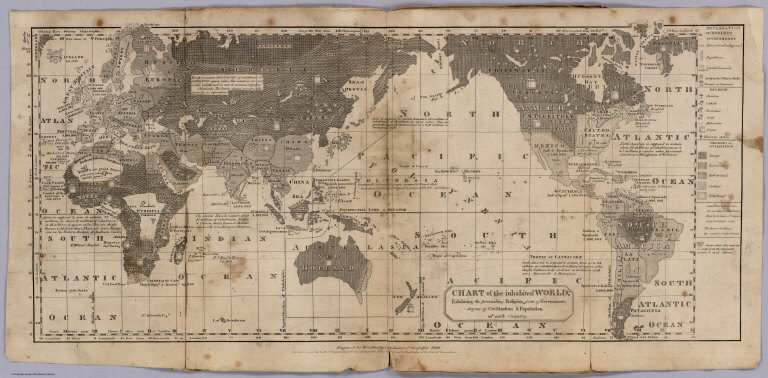
Author
Woodbridge, William C.
Full Title
Moral & political chart of the inhabited World; exhibiting the prevailing religion, form of government, degree of civilization, and population of each country. By W.C. Woodbridge. Entered ... 28th day of September 1821 by Wm. C. Woodbridge ... Connecticut. (1837?)
List No
2573.002
Note
Engraved map. Includes inset map "Central Europe" and table "Distribution of mankind with their races & religions, 1826." Prime meridians: Philadelphia and London.
Author
Woodbridge, William C.
Full Title
Isothermal chart, or view of climates & productions; drawn from the accounts of Humboldt & others, by W.C. Woodbridge. Entered ... 15th day of January, 1823, by William C. Woodbridge ... Connecticut. (1837?)
List No
2573.004
Note
Engraved map. Hand colored. Shows climate zones with plant products.
Author
Woodbridge, William C.
Full Title
Chart of the principal animals of the World in their respective regions. By W.C. Woodbridge. Entered ... 1831, by William C. Woodbridge ... Connecticut. (1837?)
List No
2573.005
Note
Engraved pictorial map. Includes inset of Australia and surroundings.
Author
Monin, C.V.
Full Title
Tableau de Geographie Physique.
List No
2613G
Note
A diagram/map consisting of several parts: a hypothetical map of labeled geographical features, five miniature engravings of seascapes and landscapes, diagrams of astronomical features and phenomena, and illustrations of longitude and latitude.
Author
Monin, C.V.
Full Title
Mappemonde en Deux Hemispheres. Paris, Hocquart, Editeur.
List No
2613.001
Note
Fold out map includes continental boundaries outlined in color and tables and drawing of mountain heights. Prime meridian Paris. Relief shown with hachures.
Author
Cummings, J. A. (Jacob Abbot)
Full Title
The World. Published by Cummings & Hilliard, No. 1, Cornhill, Boston. H. Morse Sc. (1821?)
List No
2640.001
Note
Engraved double hemisphere map. Outline hand color. Relief shown pictorially.
Full Title
The World. Philadelphia: Published by M. Carey and Son. 1820.
List No
2682.001
Note
Engraved map. Outline hand color. Relief shown pictorially.
Author
[Cleobury, Miss., Wilkinson, R.]
Full Title
The World. Copied from Wilkinson's General Atlas. (to accompany) Practical Geography; In A Series of Exercises, Illustrative Of The Geography Of All The Countries In The Civilized World ... By Miss Cleobury, Of Nottingham.1815.
List No
2687.008
Note
Outline color map of the World, on page 35x49.5. Shows Western and Eastern Hemispheres.
Author
[Faden, William, 1750?-1836, Jefferys, Thomas]
Full Title
A chart of the World upon Mercator's projection. Describing the tracks of Capt. Cook in the year 1768, 69, 70, 71, and in 1772, 73, 74, 75, with the new discoveries. London, publish'd according to Act of Parliament by Jefferys & Faden, Corner of St. Martin's Lane, Charing Cross. 1775.
List No
2835.017
Note
Engraved map. Boundaries and routes in outline hand color. Relief shown pictorially. David Rumsey Collection copy imperfect: imprint cropped off (information in Full Title field supplied by cataloger)
Author
[Faden, William, 1750?-1836, Jefferys, Thomas]
Full Title
A chart of the World upon Mercator's projection. London, published by Jefferys & Faden, Corner of St. Martin's Lane, Charing Cross. (1775?).
List No
2835.018
Note
Engraved map. Blank outline map to be completed students; with title, imprint, grid lines and compass rose only.
Author
Willard, Emma
Full Title
Map No. 1. Countries Known To The Ancients. So Arranged as to Show by the Characters & Colours Used during Which of the Six Epocha's into Which Ancient Time is Divided, Each Century Become Known. Entered according to act of Congress 5th. Day of September 1827 by Oliver D. Cooke & Co. of the State of Connecticut.
List No
3023.002
Note
Maps are bound in heavy yellow paper covers printed with "Ancient Atlas, To Accompany The Universal Geography. By William C. Woodbridge, And Emma Willard ... Maps By Emma Willard, Principal Of The Female Seminary At Troy. Hartford: Belknap And Hamersley..." Full color.
Author
Willard, Emma
Full Title
Map No. II. The World As Known To The Ancients. The Modern Name of Places Inserted on this Map... Placed under the Ancient names... Entered according to act of Congress 5th. Day of September 1827 by Oliver D. Cooke & Co. of the State of Connecticut.
List No
3023.003
Note
Maps are bound in heavy yellow paper covers printed with "Ancient Atlas, To Accompany The Universal Geography. By William C. Woodbridge, And Emma Willard ... Maps By Emma Willard, Principal Of The Female Seminary At Troy. Hartford: Belknap And Hamersley..." Full color.
Author
Willard, Emma
Full Title
Map No. VI. Migrations, Settlements &c Of Barbarous Tribes. Illustrating the Account which is given to Them in Willard's Ancient Geography. (arrow on the map) Shows the direction of the Wondering Tribes. Entered according to act of Congress 5th. Day of September 1827 by Oliver D. Cooke & Co. of the State of Connecticut.
List No
3023.007
Note
Maps are bound in heavy yellow paper covers printed with "Ancient Atlas, To Accompany The Universal Geography. By William C. Woodbridge, And Emma Willard ... Maps By Emma Willard, Principal Of The Female Seminary At Troy. Hartford: Belknap And Hamersley..." Full color.
Author
Woodbridge, William C.
Full Title
The World. Entered ... 1821, by William C. Woodbridge ... Cunnecticut. (to accompany) Woodbridge's Larger Atlas. Atlas On A New Plan, Exhibiting The Prevailing Religions, Forms Of Government, Degrees Of Civilization, And The Comparative Size Of Towns, Rivers And Mountains. By William C. Woodbridge, A.M. ... Hartford: Published by Samuel G. Goodrich ...
List No
3024.002
Note
Map is hand painted with outline color. Covers are marbled paper covered cardboard 25x16 with a paper label printed title with "Woodbridge's Larger Atlas. Atlas On A New Plan, Exhibiting The Prevailing Religions, Forms Of Government, Degrees Of Civilization, And The Comparative Size Of Towns, Rivers And Mountains. By William C. Woodbridge, A.M. ... Hartford: Published by Samuel G. Goodrich in black.". Includes insets of Geographical Divisions. Zones, Parallels, Circles and Meridians.
Author
Woodbridge, William C.
Full Title
Chart Of the Inhabited World; Exhibiting The Prevailing Religion, Form Of Government, Degree Of Civilization & Population Of Each Country. Entered ... 1821, by William C. Woodbridge ... Cunnecticut. ( to accompany) Woodbridge's Larger Atlas. Atlas On A New Plan, Exhibiting The Prevailing Religions, Forms Of Government, Degrees Of Civilization, And The Comparative Size Of Towns, Rivers And Mountains. By William C. Woodbridge, A.M. ... Hartford: Published by Samuel G. Goodrich ...
List No
3024.003
Note
Map is printed without color. Covers are marbled paper covered cardboard 25x16 with a paper label printed with title "Woodbridge's Larger Atlas. Atlas On A New Plan, Exhibiting The Prevailing Religions, Forms Of Government, Degrees Of Civilization, And The Comparative Size Of Towns, Rivers And Mountains. By William C. Woodbridge, A.M. ... Hartford: Published by Samuel G. Goodrich in black." Includes explanation of elements. Prime meridians are Philadelphia and Greenwich or London.
Author
[Reynolds, James, Emslie, John]
Full Title
Geographical diagram of the earth : adapted for illustrating its movements &c. London. Published by James Reynolds 174 Strand. Rocks & Co. Reeves & Sons. Peacock & Mansfield.(to accompany) Geological Diagrams. (with insets).
List No
3431.003
Note
Hand colored engraved map of 2 rotating discs each in 11.4 diameter, fixed to a card giving details of their use. Includes rotating hemispheres illustrate time zones in the world as relative to each other. Relief shown by hachures. Includes insets: The phenomena of day and night; Summer & winter, altitude of the sun in the latitude of London; Meridians of Longitude; Zones; Parallels of latitude. Includes notes.
Author
[Reynolds, James, Emslie, John]
Full Title
Physical map of the World : from the discoveries of the most eminent modern geographers. Drawn and engraved by John Emslie. Published by James Reynolds 174 Strand. London. Decr. 10th. 1849. (to accompany) Geological Diagrams.
List No
3431.004
Note
Hand colored engraved map. Relief shown by hachures. Shows the physical features of the surface of earth, the distribution of mountain ranges, deserts and the seasonal range of the Earth's icecaps. In addition global ocean currents are shown along with air and sea temperatures around the world. Includes notes.
Author
[Reynolds, James, Emslie, John]
Full Title
Tidal chart of the world. Showing the process of the wave of high water. (with) Botanical map showing the distribution of plants and their cultivation over the world. Drawn and engraved by John Emslie, Published by James Reynolds 174 Strand. London. (to accompany) Geological Diagrams.
List No
3431.010
Note
Hand colored engraved 2 maps of the world on one sheet. The first map shows the tide waves and the second the influence of the climate and environment on the species of plants which grow, represented by the colored lines. Includes notes.
Author
[Reynolds, James, Emslie, John]
Full Title
Zoological map showing the distribution of animals over the world. (inset) Perpendicular distribution of animals. (with) zoological map showing the distribution of birds & reptiles, over the world. (inset) Perpendicular distribution of birds & reptiles. Drawn and engraved by John Emslie. Published by James Reynolds 174 Strand. London. (to accompany) Geological Diagrams.
List No
3431.011
Note
Hand colored engraved 2 maps of the world on one sheet. Showing distribution of animals around the world, and the second shows the distribution of birds and reptiles. Includes notes.
Author
[Reynolds, James, Emslie, John]
Full Title
Ethnographical map showing the distribution of the human race. Drawn and engraved by John Emslie. London. Published by James Reynolds 174 Strand. Decr. 13,1851. (insets) Prevailing religions. (with) (diagram showing the skull forms of different races). (to accompany) Geological Diagrams.
List No
3431.012
Note
Hand colored engraved map of the world. Shows the population density around the world along with the ethnographic racial groups recognized at the time. Inset map also shows the global distribution of the world's various religions, and inset illustrating the skull forms of different races. Includes statistical tables and notes.
Author
Mitchell, Samuel Augustus
Full Title
The World on an equatorial projection. Map of the Eastern & Western hemispheres. The World on a polar projection. Map of the Northern & Southern Hemispheres. (with) Map of the most recent Antarctic discoveries. Entered ... 1839 by S. Augustus Mitchell ... Connecticut.
List No
3559.001
Note
Two engraved double hemisphere maps, with inset. Hand colored. Includes text "Recent Antarctic discoveries."
Author
Melish, John
Full Title
A: (Untitled landform map).
List No
3562.002
Note
Uncolored landform map. Relief shown pictorially and by hachures.
Author
Melish, John
Full Title
B: (Untitled outline map of the World).
List No
3562.003
Note
Uncolored world map. "Long. west from London."
|