|
Author
Wells, Edward, 1667-1727
Full Title
A new map of the Land of Canaan and parts adjoining shewing the division thereof among the twelve tribes of Israel. Sutton Nicholls sculp. (to accompany) A new sett of maps both of antient and present geography. 34.
List No
11181.037
Note
Copper engraved double page map. Inset: continuation map at a smaller scale of the Kingdom of Zobah, north of Syria. Map shows the shoreline of Zidon to River of Egypt. Jordan River is not shown. Relief shown pictorially. Includes explanation and compass rose.
Author
Wells, Edward, 1667-1727
Full Title
A new map shewing all the severall countries, cities, towns, and other places mentioned in the New Testament. Sutton Nicholls sculp. (with) New map showing all the several countries, cities, towns, and other places mentioned in the New Testament. (with) This draught shews the severall regions mentioned in the New Testamt. together with the cities & towns most remote from ye Holy Land, as in Italy, Mesopotamia &c. (to accompany) A new sett of maps both of antient and present geography. 35.
List No
11181.038
Note
3 copper engraved double page maps on 1 sheet. Note in map 1: This draught shews such places ... as were in the Holy Land, and parts adjoining. Relief shown pictorially. Includes notes.
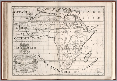
Author
Wells, Edward, 1667-1727
Full Title
A new map of Libya or old Africk shewing its general divisions, most remarkable countries or people, cities, townes, rivers, mountains &c. R. Spofforth sculp. (to accompany) A new sett of maps both of antient and present geography. 36.
List No
11181.039
Note
Copper engraved double page map of ancient Africa. Relief shown pictorially. Includes abbreviations.
Author
Wells, Edward, 1667-1727
Full Title
A new map of Africk shewing its present divisions, cheif cities or townes, rivers, mountains &c. R. Spofforth sculp. (to accompany) A new sett of maps both of antient and present geography. 37.
List No
11181.040
Note
Copper engraved double page map of present Africa. Relief shown pictorially. Includes abbreviations.
Author
Wells, Edward, 1667-1727
Full Title
A new map of the north part of antient Africa shewing the chiefe people, cities, towns, rivers, mountains, &c. in Mauritania, Numidia, Africa Propria, Libya Propria and Egypt. R. Spofforth sculp. (to accompany) A new sett of maps both of antient and present geography. 38.
List No
11181.041
Note
Copper engraved double page map of North Africa. Relief shown pictorially. Includes abbreviations and compass rose.
Author
Wells, Edward, 1667-1727
Full Title
A new map of North America shewing its principal divisions, chief cities, townes, rivers, mountains &c. Delin. M. Burg., sculpt., Univ. Oxon. (to accompany) A new sett of maps both of antient and present geography. 39.
List No
11181.042
Note
Copper engraved double page map of North America. Showing many of the early English settlements and American Colonial cities. Relief shown pictorially. Includes abbreviations. and annotations and dates of discovery.
Author
Wells, Edward, 1667-1727
Full Title
A new map of South America shewing its general divisions, chief cities, towns, rivers, mountains &c. Delin. B. Cole, sculpt., Univ. Oxon. (to accompany) A new sett of maps both of antient and present geography. 40.
List No
11181.043
Note
Copper engraved double page map of South America. Relief shown pictorially. Includes abbreviations.
Author
Wells, Edward, 1667-1727
Full Title
A new map of the most considerable plantations of the English in America. Sutton Nicolls sculp. (insets) New Scotland. (with) I. of Jamaica. (with) I. of Barbados. (with) Bermudaz or Sommers Isles. (with) Carolina. (to accompany) A new sett of maps both of antient and present geography. 41.
List No
11181.044
Note
Copper engraved double page map of the British Colonies in North America at the beginning of the 1700s. Includes explanations.
Author
[Euler, Leonhard, 1707-1783, Sauerbrey, Nicolaus Friedrich, Rhode, Johann Christoph]
Full Title
Mappa Geographica Utriusque Terrae. Hemisphaerii ad emendatiora exempla adhuc edita jusfu Acad Regiae Scient et Eleg Litt Borus-Sicae desoripta. (to accompany) Atlas geographicus omnes orbis terrarum regiones = Atlas geographique representant en XLI cartes toutes les regions de la terre ... Berolini : Ex officina Michaelis MDCCLIII (1753).
List No
11392.009
Note
Outline hand colored double hemisphere map of the World on 2 sheets. Showing the ocean currents near the equator. Includes 4 hemisphere insets showing various projections of the earth's surface. Relief shown pictorially. In lower right corner: 19. Globus generalis.
Author
[Euler, Leonhard, 1707-1783, Sauerbrey, Nicolaus Friedrich]
Full Title
Tabula Geographica utriusque Hemisphaerii Terrestris exhibens declinationem acus magneticae pro singulis locis globi terraquei ad A. C. 1744. Iussu Acad: Reg: Scient: et El: Litt: Bor: descripta. N.F. Sauerbrey fecit. (to accompany) Atlas geographicus omnes orbis terrarum regiones = Atlas geographique representant en XLI cartes toutes les regions de la terre ... Berolini : Ex officina Michaelis MDCCLIII (1753).
List No
11392.010
Note
Outline hand colored double hemisphere map of the World on 2 sheets. Showing magnetic declination lines. Relief shown pictorially. Includes descriptive text in lower panel. In lower right corner: 9. Declination der magnet nadel.
Author
[Euler, Leonhard, 1707-1783, Rhode, Johann Christoph]
Full Title
Tabula geographica Hemisphaerii Borealis : ad emendatiora quae adhuc prodierunt exempla, jussu Acad. Reg. Scient. et Eleg. Litt. Boruss. descripta ; I.C. Rhode delin. (to accompany) Atlas geographicus omnes orbis terrarum regiones = Atlas geographique representant en XLI cartes toutes les regions de la terre ... Berolini : Ex officina Michaelis MDCCLIII (1753).
List No
11392.011
Note
Hand colored copperplate engraving map of Northern Hemisphere on 2 sheets. Relief shown pictorially. Shows extensive river system connecting it with the Great Lakes and thus forming a Northwest Passage. In lower right corner: 23. Hemisphaerium Boreale. Prime meridian is Ferro.
Author
[Euler, Leonhard, 1707-1783, Rhode, Johann Christoph]
Full Title
Tabula geographica hemisphaerii Australis : ad emendatiora quae adhuc prodierunt exempla, jussu Acad. Reg. Scient. et Eleg. Litt. Boruss. descripta ; I.C. Rhode delin. (to accompany) Atlas geographicus omnes orbis terrarum regiones = Atlas geographique representant en XLI cartes toutes les regions de la terre ... Berolini : Ex officina Michaelis MDCCLIII (1753).
List No
11392.012
Note
Hand colored copperplate engraving map of Southern Hemisphere on 2 sheets. Relief shown pictorially. Shows Tasmania and New Guinea still joined to Australia, South Africa, South America. In lower right corner: 22. Hemisphaerium Australe. Prime meridian is Ferro.
Author
[Euler, Leonhard, 1707-1783, Rhode, Johann Christoph]
Full Title
Mappa Mundi generalis : ad emendatiora exempla adhuc edita , jussu Acad. Reg. Scient. et Eleg. Litt. Boruss. Descripta ; I.C. Rhode delin. Sauerbrey Sculp. (to accompany) Atlas geographicus omnes orbis terrarum regiones = Atlas geographique representant en XLI cartes toutes les regions de la terre ... Berolini : Ex officina Michaelis MDCCLIII (1753).
List No
11392.013
Note
Hand colored copperplate engraving map on 2 sheets. Shows North America the Northwest coast is blank and a river provides passage between the Great Lakes and the Pacific. Australia and New Zealand are depicted with partially completed coastlines. Relief shown pictorially. Prime meridian is Ferro. Includes two large explanation tables. In lower right corner: 27. Mappa Mundi Generalis.
Author
[Euler, Leonhard, 1707-1783, Rhode, Johann Christoph, Berger]
Full Title
Carte des differentes operations faites pour determiner la figure de la terre. Carte de l'arc du meridien mesure au Perou par les Academiciens de Paris. Carte de l'arc du meridien mesure au Cercle Polaire par les Academiciens de Paris.--Carte de l'arc du meridien mesure en France par Mons. Picard. des. par I.C.R. Grave par Berger a Berlin. (to accompany) Atlas geographicus omnes orbis terrarum regiones = Atlas geographique representant en XLI cartes toutes les regions de la terre ... Berolini : Ex officina Michaelis MDCCLIII (1753).
List No
11392.014
Note
Hand colored copperplate engraving map on 2 sheets. Showing various operations conducted to determine the shape of the Earth. Relief shown pictorially. Includes explanation text. In lower right corner: Von figur der Erde.
Author
Euler, Leonhard, 1707-1783
Full Title
Tab. Geogr. Europae ad emendatiora quoe ad huc prodierunt exempla jussu Acad. Reg Scient eceleg. Litt. Pruss descripta. (to accompany) Atlas geographicus omnes orbis terrarum regiones = Atlas geographique representant en XLI cartes toutes les regions de la terre ... Berolini : Ex officina Michaelis MDCCLIII (1753).
List No
11392.015
Note
Hand colored copperplate engraving map on 2 sheets. Showing mountains, rivers, lakes, geographical and coastal features, political boundaries, cities, and principal towns. Relief shown pictorially. In lower right corner: 11. Europa.
Author
[Euler, Leonhard, 1707-1783, Sauerbrey, Nicolaus Friedrich]
Full Title
Tabula Geographica Europae ad emendatiora exempla adhuc edita jussu Acad. Reg. scient. et litt. eleg. Boruss descripta. (to accompany) Atlas geographicus omnes orbis terrarum regiones = Atlas geographique representant en XLI cartes toutes les regions de la terre ... Berolini : Ex officina Michaelis MDCCLIII (1753).
List No
11392.016
Note
1 map on 4 sheets. In lower right corner: 12. Europa. Hand colored copperplate engraving map on 2 sheets. Covers Northern Europe, Norway, most of Great Britain, Ireland, Iceland, and a long stretch of Greenland's eastern coast. Showing mountains, rivers, lakes, geographical and coastal features, political boundaries, cities, and principal towns. Relief shown pictorially. Prime meridian is Ferro.
Author
[Euler, Leonhard, 1707-1783, Sauerbrey, Nicolaus Friedrich]
Full Title
Tabula Geographica Europae ad emendatiora exempla adhuc edita jussu Acad. Reg. scient. et litt. eleg. Boruss descripta. Sauerbrey sculp. (to accompany) Atlas geographicus omnes orbis terrarum regiones = Atlas geographique representant en XLI cartes toutes les regions de la terre ... Berolini : Ex officina Michaelis MDCCLIII (1753).
List No
11392.017
Note
1 map on 4 sheets. In lower right corner: 13. Europa. Hand colored copperplate engraving map on 2 sheets. Covers Northern Europe. Showing mountains, rivers, lakes, geographical and coastal features, political boundaries, cities, and principal towns. Relief shown pictorially. Prime meridian is Ferro.
Author
[Euler, Leonhard, 1707-1783, Sauerbrey, Nicolaus Friedrich]
Full Title
Tabula Geographica Europae ad emendatiora exempla adhuc edita jussu Acad. Reg. scient. et litt. eleg. Boruss descripta. Sauerbrey sculp. (to accompany) Atlas geographicus omnes orbis terrarum regiones = Atlas geographique representant en XLI cartes toutes les regions de la terre ... Berolini : Ex officina Michaelis MDCCLIII (1753).
List No
11392.018
Note
1 map on 4 sheets. In lower right corner: 14. Europa. Hand colored copperplate engraving map on 2 sheets. Covers Western Europe. Showing mountains, rivers, lakes, geographical and coastal features, political boundaries, cities, and principal towns. Relief shown pictorially. Prime meridian is Ferro.
Author
[Euler, Leonhard, 1707-1783, Sauerbrey, Nicolaus Friedrich]
Full Title
Tabula Geographica Europae ad emendatiora exempla adhuc edita jussu Acad. Reg. scient. et litt. eleg. Boruss descripta. Sauerbrey sculp. (to accompany) Atlas geographicus omnes orbis terrarum regiones = Atlas geographique representant en XLI cartes toutes les regions de la terre ... Berolini : Ex officina Michaelis MDCCLIII (1753).
List No
11392.019
Note
1 map on 4 sheets. In lower right corner: 15. Europa. Hand colored copperplate engraving map on 2 sheets. Covers Southern Europe. Showing mountains, rivers, lakes, geographical and coastal features, political boundaries, cities, and principal towns. Relief shown pictorially. Prime meridian is Ferro.
Author
Euler, Leonhard, 1707-1783
Full Title
Tab. Geogr. Hispaniae ad emendatiora exempla adhuc edita jussu Acad. Reg. scient. et eleg. litt. Boruss descripta. Sauerbrey sculp. (to accompany) Atlas geographicus omnes orbis terrarum regiones = Atlas geographique representant en XLI cartes toutes les regions de la terre ... Berolini : Ex officina Michaelis MDCCLIII (1753).
List No
11392.021
Note
Hand colored copperplate engraving map on 2 sheets. Showing mountains, rivers, lakes, geographical and coastal features, political boundaries, cities, and principal towns. Relief shown pictorially. In lower right corner: 38 Spanien u. Portugal.
Author
[Euler, Leonhard, 1707-1783, Claussen, I.C. G.]
Full Title
Tabula geogr: Galliae ad emendatiora que adhuc prodierunt exemple jussu quae adhuc edita jussu Acad. Reg. scient. et eleg. litt. Boruss descripta. I.C.G. Claussen del. (to accompany) Atlas geographicus omnes orbis terrarum regiones = Atlas geographique representant en XLI cartes toutes les regions de la terre ... Berolini : Ex officina Michaelis MDCCLIII (1753).
List No
11392.022
Note
Hand colored copperplate engraving map on 2 sheets. Showing mountains, rivers, lakes, geographical and coastal features, administrative boundaries, cities, and principal towns. Relief shown pictorially. In lower right corner: 17. Franckreich.
Author
[Euler, Leonhard, 1707-1783, Sauerbrey, Nicolaus Friedrich]
Full Title
Tabula geographica Italiae ad emendatiora exampla adhuc edita jussu Acad. Reg. scient. et eleg. litt. Boruss descripta. N.F. Sauerbrey sculpsit Berolin. (to accompany) Atlas geographicus omnes orbis terrarum regiones = Atlas geographique representant en XLI cartes toutes les regions de la terre ... Berolini : Ex officina Michaelis MDCCLIII (1753).
List No
11392.023
Note
Hand colored copperplate engraving map on 2 sheets. Showing mountains, rivers, lakes, geographical and coastal features, administrative boundaries, cities, and principal towns. Relief shown pictorially. In lower right corner: 26 Italien.
Author
Euler, Leonhard, 1707-1783
Full Title
Tabula geograph: Britanniae ad emendatiora exampla adhuc edita jussu Acad. Reg. scient. et eleg. litt. Prussiae descripta. (to accompany) Atlas geographicus omnes orbis terrarum regiones = Atlas geographique representant en XLI cartes toutes les regions de la terre ... Berolini : Ex officina Michaelis MDCCLIII (1753). (inset) Orcades Insvlae.
List No
11392.024
Note
Hand colored copperplate engraving map on 2 sheets. Showing mountains, rivers, lakes, geographical and coastal features, administrative boundaries, cities, and principal towns. Relief shown pictorially. Includes explanation table. In lower right corner: 21 Gross Brittanien.
Author
[Euler, Leonhard, 1707-1783, Sauerbrey, Nicolaus Friedrich]
Full Title
Tabula geographica Angliae et Walliae ad emendatiora exampla adhuc edita jussu Acad. Reg. scient. et eleg. litt. Boruss descripta. Sauerbrey sculp. (to accompany) Atlas geographicus omnes orbis terrarum regiones = Atlas geographique representant en XLI cartes toutes les regions de la terre ... Berolini : Ex officina Michaelis MDCCLIII (1753). (inset) Orcades Insvlae.
List No
11392.025
Note
Hand colored copperplate engraving map on 2 sheets. Showing mountains, rivers, lakes, geographical and coastal features, administrative boundaries, cities, and principal towns. Relief shown pictorially. In lower right corner: 10. Engeland 1 Theil.
Author
Euler, Leonhard, 1707-1783
Full Title
Tabvla geographca Scotia ad emendatiora que adhuc prodierunt exampla jussu ACAD. Reg. Scient. et eleg. litter: descripta. (to accompany) Atlas geographicus omnes orbis terrarum regiones = Atlas geographique representant en XLI cartes toutes les regions de la terre ... Berolini : Ex officina Michaelis MDCCLIII (1753). (inset) Great Britain.
List No
11392.026
Note
Hand colored copperplate engraving map on 2 sheets. Showing mountains, rivers, lakes, geographical and coastal features, administrative boundaries, cities, and principal towns. Relief shown pictorially. In lower right corner: 35. Schottland. 1 T.
Author
Euler, Leonhard, 1707-1783
Full Title
Mappa geographica Regni Hiberniae ad emendatiora que adhuc prodierunt exampla jussu ACAD. Reg. Scient. et eleg. litter: descripta. (to accompany) Atlas geographicus omnes orbis terrarum regiones = Atlas geographique representant en XLI cartes toutes les regions de la terre ... Berolini : Ex officina Michaelis MDCCLIII (1753). (inset) Great Britain.
List No
11392.027
Note
Hand colored copperplate engraving map on 2 sheets. Showing mountains, rivers, lakes, geographical and coastal features, administrative boundaries, cities, and principal towns. Relief shown pictorially. In lower right corner: 25. Irrland. 1 T.
Author
Euler, Leonhard, 1707-1783
Full Title
Tabula geogr: Belgii Universi VII Provinc ad emendatiora exampla adhuc jussu Acad. Reg. Scient. et Eleg. litter. Boruss: descripta. (to accompany) Atlas geographicus omnes orbis terrarum regiones = Atlas geographique representant en XLI cartes toutes les regions de la terre ... Berolini : Ex officina Michaelis MDCCLIII (1753).
List No
11392.028
Note
Hand colored copperplate engraving map on 2 sheets. Showing administrative boundaries, mountains, rivers, lakes, geographical and coastal features, cities, and principal towns. Relief shown pictorially. Includes explanation table. Prime meridian is Ferro. In lower right corner: 29. Niederlande.
Author
Euler, Leonhard, 1707-1783
Full Title
Tab. Geo. Imperia Rom. Germanicia ad emendatiora adhuc edita exempla jussu Acad. Reg. Scient. et eleg. Litter Borussiae descript. (to accompany) Atlas geographicus omnes orbis terrarum regiones = Atlas geographique representant en XLI cartes toutes les regions de la terre ... Berolini : Ex officina Michaelis MDCCLIII (1753).
List No
11392.029
Note
Hand colored copperplate engraving map on 2 sheets. Showing administrative boundaries, mountains, rivers, lakes, geographical and coastal features, cities, and principal towns. Relief shown pictorially. In lower right corner: 39. Teutschland.
Author
Euler, Leonhard, 1707-1783
Full Title
Mappa geograph. circuli Westphalici, Rhenani superioris, Belgii Foederati et catholici ad emendatoria exemplaria adhuc edita jussu Acad. Reg. Scient. et Eleg. Litt. descript. (to accompany) Atlas geographicus omnes orbis terrarum regiones = Atlas geographique representant en XLI cartes toutes les regions de la terre ... Berolini : Ex officina Michaelis MDCCLIII (1753).
List No
11392.030
Note
Hand colored copperplate engraving map on 2 sheets. Showing administrative boundaries, mountains, rivers, lakes, geographical and coastal features, cities, and principal towns. Relief shown pictorially. In lower right corner: 24. Holland, Niederlandwe, Westphalen, Hessen.
Author
Euler, Leonhard, 1707-1783
Full Title
Tabula Geographica Circ. Saxoniae Superioris et Inferioris : Ad Emendatiora Exemplaria Adhuc Edita jussu Acad. Reg. Scient. Et Eleg. Litt. Descripta. (to accompany) Atlas geographicus omnes orbis terrarum regiones = Atlas geographique representant en XLI cartes toutes les regions de la terre ... Berolini : Ex officina Michaelis MDCCLIII (1753).
List No
11392.031
Note
Hand colored copperplate engraving map on 2 sheets. Showing administrative boundaries, mountains, rivers, lakes, geographical and coastal features, cities, and principal towns. Relief shown pictorially. In lower right corner: 34. Ober und Nieder Sachsen.
Author
Euler, Leonhard, 1707-1783
Full Title
Mappa geographica Sveviae, Helvetiae, Lotharingiae, et adjacentium Regionum ad emendatiora exempla adhuc edita jussu Reg. Acad. Scient. et Eleg. Litter. descripta. (to accompany) Atlas geographicus omnes orbis terrarum regiones = Atlas geographique representant en XLI cartes toutes les regions de la terre ... Berolini : Ex officina Michaelis MDCCLIII (1753).
List No
11392.032
Note
Hand colored copperplate engraving map on 2 sheets. Showing Political and administrative boundaries, mountains, rivers, lakes, geographical and coastal features, cities, and principal towns. Relief shown pictorially. In lower right corner: 36. Schwaben, Schweitz, Lothringen.
Author
Euler, Leonhard, 1707-1783
Full Title
Tab: Geogr: Circ. Franconiae Dimid. Saxoniae Superioris Regni Bohemiae March Lusatiae Ac Duc Silesiae, ad emendatiora quae adhuc prodierunt exempla jussu Reg Acad Scient et Eleg Litt. Boruss descripta. (to accompany) Atlas geographicus omnes orbis terrarum regiones = Atlas geographique representant en XLI cartes toutes les regions de la terre ... Berolini : Ex officina Michaelis MDCCLIII (1753).
List No
11392.033
Note
Hand colored copperplate engraving map on 2 sheets. Covers part of Poland, Germany and the Czech Republic. Showing Political and administrative boundaries, mountains, rivers, lakes, cities, and principal towns. Relief shown pictorially. In lower right corner: 16. Francken, Bohmen, Maehren, Schlesien, Lausnitz.
Author
Euler, Leonhard, 1707-1783
Full Title
Tabula geographica circulorum Austriaci et Bavarici imperii Romano-Germanici : ad emendatiora exempla adhuc edita jussu Academiae Regiae Scientiarum et eleg. Litt. Borussicae descripta. (to accompany) Atlas geographicus omnes orbis terrarum regiones = Atlas geographique representant en XLI cartes toutes les regions de la terre ... Berolini : Ex officina Michaelis MDCCLIII (1753).
List No
11392.034
Note
Hand colored copperplate engraving map on 2 sheets. Covers Austria and Bavaria. Showing Political and administrative boundaries, mountains, rivers, lakes, forests, cities, and principal towns. Relief shown pictorially. In lower right corner: 30. Oesterreich- und Bayerischer Creis.
Author
[Euler, Leonhard, 1707-1783, Rhode, Johann Christoph, Berger, Friedrich Gottlieb]
Full Title
Tabula geographica principatus Anhaltini et Finitimarum regionum ; Kartenmaterial ; correctior reddita jussu Academ. Reg. Scient. et Elegant Litt. Boruss. per I.C.R. Berger, sculpsit. (to accompany) Atlas geographicus omnes orbis terrarum regiones = Atlas geographique representant en XLI cartes toutes les regions de la terre ... Berolini : Ex officina Michaelis MDCCLIII (1753).
List No
11392.035
Note
Hand colored copperplate engraving map on 2 sheets. Showing administrative boundaries, mountains, rivers, lakes, forest, cities, and principal towns. Relief shown pictorially.
Author
[Euler, Leonhard, 1707-1783, Rhode, Johann Christoph, Berger, Friedrich Gottlieb]
Full Title
Mappa Geographica Landgrav, Thuringia cum Regionibus Adiacentibuts.
List No
11392.036
Note
Showing administrative boundaries, mountains, rivers, lakes, forest, cities, and principal towns. Relief shown pictorially.
Author
[Euler, Leonhard, 1707-1783, Rhode, Johann Christoph, Sauerbrey, Nicolaus Friedrich]
Full Title
Tabula Geographica Marchionat. Misniae et Lusatiae : jussu Acedem. Reg. Scient. et Elegant. Litter Boruss. correctior reddita a I. C. R. Sauerbrey sculpsit. (to accompany) Atlas geographicus omnes orbis terrarum regiones = Atlas geographique representant en XLI cartes toutes les regions de la terre ... Berolini : Ex officina Michaelis MDCCLIII (1753).
List No
11392.037
Note
Hand colored copperplate engraving map on 2 sheets. Showing administrative boundaries, mountains, rivers, lakes, forest, cities, and principal towns. Relief shown pictorially.
Author
[Euler, Leonhard, 1707-1783, Rhode, Johann Christoph, Berger, Friedrich Gottlieb]
Full Title
Borussia regia et Ducalis : jussu ACAD. Reg. Scient. et El. Litt. exactissime descripta a I. C.R.A.G., Berger sc. (to accompany) Atlas geographicus omnes orbis terrarum regiones = Atlas geographique representant en XLI cartes toutes les regions de la terre ... Berolini : Ex officina Michaelis MDCCLIII (1753).
List No
11392.038
Author
Euler, Leonhard, 1707-1783
Full Title
Tabula Geographica Regni Poloniae : ad emendatiora adhuc edita exempla jussu Acad: Reg: Scient: et Eleg: Litt: Borussicae descripta. (to accompany) Atlas geographicus omnes orbis terrarum regiones = Atlas geographique representant en XLI cartes toutes les regions de la terre ... Berolini : Ex officina Michaelis MDCCLIII (1753).
List No
11392.039
Note
Hand colored copperplate engraving map on 2 sheets. Showing administrative boundaries, mountains, rivers, lakes, forest, cities, and principal towns. Relief shown pictorially. In lower right corner: 31. Pohlen.
Author
Euler, Leonhard, 1707-1783
Full Title
Tabula Geographica Regni Hungariae cum finitimis Regionibus : ad emendatiora Exempla ad huc edita jussu Academiae Regiae Scient. et Eleg. litt. Borussicae descripta. (to accompany) Atlas geographicus omnes orbis terrarum regiones = Atlas geographique representant en XLI cartes toutes les regions de la terre ... Berolini : Ex officina Michaelis MDCCLIII (1753).
List No
11392.040
Note
Hand colored copperplate engraving map on 2 sheets. Showing administrative boundaries, mountains, rivers, lakes, forest, cities, and principal towns. Relief shown pictorially. Prime meridian is Paris. In lower right corner: 41. Ungern.
Author
Euler, Leonhard, 1707-1783
Full Title
Tab. Geogr. Graeciae et Romaniae : ad Exempla emendatiora ad huc edita jussu Acad. Regiae Scient. et eleg. Litt. Borussicae descripta. (to accompany) Atlas geographicus omnes orbis terrarum regiones = Atlas geographique representant en XLI cartes toutes les regions de la terre ... Berolini : Ex officina Michaelis MDCCLIII (1753).
List No
11392.041
Note
Hand colored copperplate engraving map on 2 sheets. Showing administrative boundaries, mountains, rivers, lakes, forest, cities, and principal towns. Relief shown pictorially. In lower right corner: 20. Griecenland.
Author
[Euler, Leonhard, 1707-1783, Sauerbrey, Nicolaus Friedrich]
Full Title
Tabula Geographica Imperii Turcici : ad emendatiora Exempla adhuc edita jussu Academ. Reg. scient. et litt. eleg. Boruss. descripta. N. F. Sauerbrey sculp. Berlin. (to accompany) Atlas geographicus omnes orbis terrarum regiones = Atlas geographique representant en XLI cartes toutes les regions de la terre ... Berolini : Ex officina Michaelis MDCCLIII (1753).
List No
11392.042
Note
Hand colored copperplate engraving map on 2 sheets. Showing administrative boundaries, mountains, rivers, lakes, forest, cities, and principal towns. Relief shown pictorially. In lower right corner: 40. Turkey.
Author
[Euler, Leonhard, 1707-1783, Sauerbrey, Nicolaus Friedrich]
Full Title
Tabula Geographica Regni Dania.
List No
11392.043
Note
Hand colored copperplate engraving map on 2 sheets. Showing administrative boundaries, mountains, rivers, lakes, forest, cities, and principal towns. Relief shown pictorially. In lower right corner: 40. Turkey.
Author
[Euler, Leonhard, 1707-1783, Sauerbrey, Nicolaus Friedrich]
Full Title
Tabula Geographica Regnorum Sveciae Daniae et Norwegiae : ad emendatiora Exempla adhuc edita jussu Acad. Reg. scient. et litter. eleg. Boruss. descripta. Sauerbrey sculp. (to accompany) Atlas geographicus omnes orbis terrarum regiones = Atlas geographique representant en XLI cartes toutes les regions de la terre ... Berolini : Ex officina Michaelis MDCCLIII (1753).
List No
11392.044
Note
Hand colored copperplate engraving map on 2 sheets. Showing administrative boundaries, mountains, rivers, lakes, forest, cities, and principal towns. Relief shown pictorially. In lower right corner: 55. Schweden.
Author
Euler, Leonhard, 1707-1783
Full Title
Tab: Geogr: Imperii Rvssici : ad emendatiora adhuc edita exempla jussu Acad. Reg. Scient. et eleg. Litt. Boruss. descripta. (to accompany) Atlas geographicus omnes orbis terrarum regiones = Atlas geographique representant en XLI cartes toutes les regions de la terre ... Berolini : Ex officina Michaelis MDCCLIII (1753).
List No
11392.045
Note
Hand colored copperplate engraving map on 2 sheets. Showing administrative boundaries, mountains, rivers, lakes, forest, cities, and principal towns. Relief shown pictorially. In lower right corner: 33. Russland.
Author
Euler, Leonhard, 1707-1783
Full Title
Tab. geogr. Asiae : ad emendatiora, quae adhuc prodierunt, exempla jussu Acad. Reg. Scient. et Eleg. Litt. Boruss. descripta. (to accompany) Atlas geographicus omnes orbis terrarum regiones = Atlas geographique representant en XLI cartes toutes les regions de la terre ... Berolini : Ex officina Michaelis MDCCLIII (1753).
List No
11392.046
Note
Hand colored copperplate engraving map on 2 sheets. Showing political boundaries, mountains, rivers, lakes, cities, and principal towns. Relief shown pictorially. In lower right corner: 7. Asia.
Author
Euler, Leonhard, 1707-1783
Full Title
Tab. geogr. Palaestinae : ad emendatiora quae adhuc prodierunt exempla jussu Acad. Reg. Scient. et eleg. litt. Pruss. descripta. (to accompany) Atlas geographicus omnes orbis terrarum regiones = Atlas geographique representant en XLI cartes toutes les regions de la terre ... Berolini : Ex officina Michaelis MDCCLIII (1753). (inset) Conspectus terrae Canaan uti a priseis incolis fuit inhabitata.
List No
11392.047
Note
Hand colored copperplate engraving map on 2 sheets. Showing political boundaries, geographic features, mountains, rivers, lakes, cities, and principal towns. Relief shown pictorially. In lower right corner: 18. Gelobte Land.
Author
[Euler, Leonhard, 1707-1783, Gericke, I.E.]
Full Title
Tab. Geogr. Africae : ad emendatiora : quae ad huc prodierunt exempla jusu Acad. Reg. Scient. et eleg. Litt. Pruss. descripta. I.E. Gericke, sc. Berol. (to accompany) Atlas geographicus omnes orbis terrarum regiones = Atlas geographique representant en XLI cartes toutes les regions de la terre ... Berolini : Ex officina Michaelis MDCCLIII (1753).
List No
11392.048
Note
Hand colored copperplate engraving map on 2 sheets. Showing political boundaries, geographic features, mountains, rivers, lakes, cities, and principal towns. Relief shown pictorially. In lower right corner: 1. Africa.
Author
Euler, Leonhard, 1707-1783
Full Title
Tab. Geogr. Americae : ad emendatiora quae adhuc prodierunt exempla jussu Acad. Reg. Scient. et Eleg. Litt. Boruss. descripta. (to accompany) Atlas geographicus omnes orbis terrarum regiones = Atlas geographique representant en XLI cartes toutes les regions de la terre ... Berolini : Ex officina Michaelis MDCCLIII (1753).
List No
11392.049
Note
Hand colored copperplate engraving map on 2 sheets. Showing political boundaries, geographic features, mountains, cities, and principal towns. Showing rivers and lakes, including Lacus Ouinipigon, appear to make way for a Northwest Passage in North America. The northern part of California is labeled Nova Albion. Relief shown pictorially. In lower right corner: 2. America.
Author
Euler, Leonhard, 1707-1783
Full Title
Americae septentrionalis pars I. (to accompany) Atlas geographicus omnes orbis terrarum regiones = Atlas geographique representant en XLI cartes toutes les regions de la terre ... Berolini : Ex officina Michaelis MDCCLIII (1753). (inset: Greenland to New Britain along Baffin Bay and Hudson Bay).
List No
11392.050
Note
Part 1 of 4 part map of North America. Hand colored copperplate engraving map on 2 sheets. Covers the region from the Mississippi River valley through the American Southwest.Showing French Louisania and the Spanish possessions in New Mexico, Tecas (Texas) in between. Inset map includes numerous English notations concerning discoveries in the region, covers Hudson and Baffin Bays. Showing geographic features, rivers, lakes, mountains, cities, and principal towns. Relief shown pictorially. In lower right corner: 3. Novell America 1. theil.
Author
Euler, Leonhard, 1707-1783
Full Title
Mappa geographica Americae Septentrionalis : ad emendatiora exemplaria adhuc edita jussu Acad. Reg. Scient. et Eleg. litt. descripta. pars. II. (to accompany) Atlas geographicus omnes orbis terrarum regiones = Atlas geographique representant en XLI cartes toutes les regions de la terre ... Berolini : Ex officina Michaelis MDCCLIII (1753).
List No
11392.051
Note
Part 2 of 4 part map of North America. Hand colored copperplate engraving map on 2 sheets. Covers colonies from St. Lawrence Gulf to Lake Superior and James Bay to Georgia. Shows names and locations of various Indian tribes. Showing geographic features, rivers, lakes, mountains, cities, and principal towns. Relief shown pictorially. In lower right corner: 4. Novell America 2. theil.
Author
Euler, Leonhard, 1707-1783
Full Title
Americae septentrionalis pars III. (to accompany) Atlas geographicus omnes orbis terrarum regiones = Atlas geographique representant en XLI cartes toutes les regions de la terre ... Berolini : Ex officina Michaelis MDCCLIII (1753).
List No
11392.052
Note
Part 3 of 4 part map of North America. Hand colored copperplate engraving map on 2 sheets. Covers the region from the Gulf Coast of the U.S. through Mexico to Honduras. Showing geographic features, rivers, lakes, mountains, cities, and principal towns. Relief shown pictorially. In lower right corner: 5. Novell America 3. theil.
Author
Euler, Leonhard, 1707-1783
Full Title
Americae septentrionalis pars IV. (to accompany) Atlas geographicus omnes orbis terrarum regiones = Atlas geographique representant en XLI cartes toutes les regions de la terre ... Berolini : Ex officina Michaelis MDCCLIII (1753).
List No
11392.053
Note
Part 4 of 4 part map of North America. Hand colored copperplate engraving map on 2 sheets. Covers Caribbean and Central America, extending north to Cumberland Island, Georgia and west to Pensacola, Florida. Showing geographic features, rivers, lakes, mountains, cities, and principal towns. Relief shown pictorially. In lower right corner: 6. Novell America 4. theil.
Author
Kiepert, Heinrich, 1818-1899
Full Title
Imperia Persarum et Macedonum. Auctore Henrico Kiepert Berolinensi. C. Ohmann, lith. Berlin D. Reimer 1858. (to accompany) Atlas Antiquus. Eight maps of the ancient world for schools and colleges, by Dr. Heinrich Kiepert M.R. Acad. Berlin. Williams and Norgate, London and Edinburgh. Berlin: Dietrich Reimer. 1859.
List No
11687.003
Note
Outline hand colored map of Persian Empire and Macedonia. Relief shown by hachures. Prime meridians are Paris and Greenwich.
Author
Kiepert, Heinrich, 1818-1899
Full Title
Asia citerior. Auctore Henrico Kiepert Berolinensi. Kraatz, L. lith. Berlin D. Reimer 1858. (to accompany) Atlas Antiquus. Eight maps of the ancient world for schools and colleges, by Dr. Heinrich Kiepert M.R. Acad. Berlin. Williams and Norgate, London and Edinburgh. Berlin: Dietrich Reimer. 1859.
List No
11687.004
Note
Outline hand colored map. Relief shown by hachures. Prime meridians are Paris and Greenwich.
Author
Kiepert, Heinrich, 1818-1899
Full Title
Graecia cum insulis et oris maris Aegaei. Auctore Henrico Kiepert Berolinensi. V. Geyer. lith. Berlin D. Reimer. (to accompany) Atlas Antiquus. Eight maps of the ancient world for schools and colleges, by Dr. Heinrich Kiepert M.R. Acad. Berlin. Williams and Norgate, London and Edinburgh. Berlin: Dietrich Reimer. 1859.
List No
11687.005
Note
Outline hand colored map by region. Relief shown by hachures. Prime meridians are Paris and Greenwich.
Author
Kiepert, Heinrich, 1818-1899
Full Title
Graecia. Auctore Henrico Kiepert Berolinensi. V. Geyer. lith. Berlin D. Reimer. (to accompany) Atlas Antiquus. Eight maps of the ancient world for schools and colleges, by Dr. Heinrich Kiepert M.R. Acad. Berlin. Williams and Norgate, London and Edinburgh. Berlin: Dietrich Reimer. 1859. (insets) Athenae. (with: Athens and surroundings).
List No
11687.006
Note
Outline hand colored map by region. Relief shown by hachures. Prime meridians are Paris and Greenwich.
Author
Kiepert, Heinrich, 1818-1899
Full Title
Italia. Auctore Henrico Kiepert Berolinensi. L. Kraatz lith. Berlin D. Reimer. (to accompany) Atlas Antiquus. Eight maps of the ancient world for schools and colleges, by Dr. Heinrich Kiepert M.R. Acad. Berlin. Williams and Norgate, London and Edinburgh. Berlin: Dietrich Reimer. 1859. (inset) Undecim regiones Italiae ab Augusto Imp. institutae.
List No
11687.007
Note
Outline hand colored map by administrative divisions. Relief shown by hachures. Prime meridians are Paris and Greenwich.
Author
Kiepert, Heinrich, 1818-1899
Full Title
Italiae pars media. ad illustrandum potissimum antiquiorem Romanorum historiam duplici ad tabulam totius Italiae modulo descripta. Auctore Henrico Kiepert Berolinensi. J. Sulzer. lith. Berlin D. Reimer. (to accompany) Atlas Antiquus. Eight maps of the ancient world for schools and colleges, by Dr. Heinrich Kiepert M.R. Acad. Berlin. Williams and Norgate, London and Edinburgh. Berlin: Dietrich Reimer. 1859. (insets) Roma Urbs. (with) Reciones proximae circa Urbem Romam. (with) Regio campaniae Neapolitana.
List No
11687.008
Note
Outline hand colored map by administrative divisions. Relief shown by hachures. Prime meridians are Paris and Greenwich. Includes index.
Author
Kiepert, Heinrich, 1818-1899
Full Title
Gallia, Britannia, Germania. C. Ohmann et J. Sulzer. lith. Berlin D. Reimer. 1858. (to accompany) Atlas Antiquus. Eight maps of the ancient world for schools and colleges, by Dr. Heinrich Kiepert M.R. Acad. Berlin. Williams and Norgate, London and Edinburgh. Berlin: Dietrich Reimer. 1859.
List No
11687.009
Note
Outline hand colored map by political divisions. Covers United Kingdom, France and Germany. Relief shown by hachures. Prime meridians are Paris and Greenwich. Includes legend.
Author
Kiepert, Heinrich, 1818-1899
Full Title
Imperium Romanum. Auctore Henrico Kiepert Berolinensi. C. Ohmann lith. Berlin D. Reimer. 1858. (to accompany) Atlas Antiquus. Eight maps of the ancient world for schools and colleges, by Dr. Heinrich Kiepert M.R. Acad. Berlin. Williams and Norgate, London and Edinburgh. Berlin: Dietrich Reimer. 1859.
List No
11687.010
Note
Outline hand colored map of ancient Roman Empire. Relief shown by hachures. Prime meridians are Paris and Greenwich. Includes legend and notes.
Author
[Kiepert, Heinrich, 1818-1899, Rand McNally and Company]
Full Title
Orbis terrarum antiquis notus : altero p. Chr. saeculo antiquis notus. Auctore Henrico Kiepert Berolinensi. Copyright 1892 by Dietrich Reimer (Ernst Vohsen). Geographische Verlagshandlung Dietrich Reimer (E. Vohsen) Berlin. (to accompany) Atlas antiquus ... Rand, McNally & Co., Chicago and New York. (insets) Regna orientis antiquissima. (with) Orbis Terrarum secundum Erathoshenem (ca. 200 a. Chr.) (with) Orbis Terrarum secundum Ptolemaeum Alexandrinum (ca. 150 p. Chr.).
List No
11690.003
Note
Color map of the ancient world. Color coded by regions. Relief shown by hachures. Includes legend.
Author
[Kiepert, Heinrich, 1818-1899, Rand McNally and Company]
Full Title
Imperia Persarum et Macedonum. Auctore Henrico Kiepert Berolinensi. Copyright 1892 by Dietrich Reimer (Ernst Vohsen). Geographische Verlagshandlung Dietrich Reimer (E. Vohsen) Berlin. (to accompany) Atlas antiquus ... Rand, McNally & Co., Chicago and New York. (insets) Regna Diadochorum. (with) Regna Graecorum.
List No
11690.004
Note
Color map of the Persian Empire and Macedonia. Color coded by regions. Relief shown by hachures. Includes legend.
Author
[Kiepert, Heinrich, 1818-1899, Rand McNally and Company]
Full Title
Aegyptus. Phoenice et Palaestina. Auctore Henrico Kiepert Berolinensi. Copyright 1892 by Dietrich Reimer (Ernst Vohsen). Geographische Verlagshandlung Dietrich Reimer (E. Vohsen) Berlin. (to accompany) Atlas antiquus ... Rand, McNally & Co., Chicago and New York. (insets) Alexandria. (with) XII tribus Israelitarum. (with) Tyrus. (with) Hierosolyma..
List No
11690.005
Note
2 color maps of Egypt and Palestine. Scale of Phoenice et Palaestina 1:1,250,000. Relief shown by hachures. Includes legend and notations.
Author
[Kiepert, Heinrich, 1818-1899, Rand McNally and Company]
Full Title
Asia citerior. Auctore Henrico Kiepert Berolinensi. Copyright 1892 by Dietrich Reimer (Ernst Vohsen). Geographische Verlagshandlung Dietrich Reimer (E. Vohsen) Berlin. (to accompany) Atlas antiquus ... Rand, McNally & Co., Chicago and New York.
List No
11690.006
Note
Color map. Relief shown by hachures. Prime meridians are Paris and Greenwich. Includes legend and notes.
Author
[Kiepert, Heinrich, 1818-1899, Rand McNally and Company]
Full Title
Graecia cum insulis et oris maris Aegaei. Auctore Henrico Kiepert Berolinensi. Copyright 1892 by Dietrich Reimer (Ernst Vohsen). Geographische Verlagshandlung Dietrich Reimer (E. Vohsen) Berlin. (to accompany) Atlas antiquus ... Rand, McNally & Co., Chicago and New York. (inset) Troas et Hellespontus.
List No
11690.007
Note
Color map. Relief shown by hachures. Prime meridians are Paris and Greenwich. Includes legend and notes.
Author
[Kiepert, Heinrich, 1818-1899, Rand McNally and Company]
Full Title
Graecia. Auctore Henrico Kiepert Berolinensi. Copyright 1892 by Dietrich Reimer (Ernst Vohsen). Geographische Verlagshandlung Dietrich Reimer (E. Vohsen) Berlin. (to accompany) Atlas antiquus ... Rand, McNally & Co., Chicago and New York. (insets) Athenae. (with) Regiones proximae circa urbem Athenas.
List No
11690.008
Note
Color map. Relief shown by hachures. Prime meridians are Paris and Greenwich. Includes legend and notes.
Author
[Kiepert, Heinrich, 1818-1899, Rand McNally and Company]
Full Title
Italia. Auctore Henrico Kiepert Berolinensi. Copyright 1892 by Dietrich Reimer (Ernst Vohsen). Geographische Verlagshandlung Dietrich Reimer (E. Vohsen) Berlin. (to accompany) Atlas antiquus ... Rand, McNally & Co., Chicago and New York. (inset) Undecim regiones Italiae ab Augusto Imp. institutae.
List No
11690.009
Note
Color map. Relief shown by hachures. Prime meridians are Paris and Greenwich.
Author
[Kiepert, Heinrich, 1818-1899, Rand McNally and Company]
Full Title
Italiae pars media. Auctore Henrico Kiepert Berolinensi. Copyright 1892 by Dietrich Reimer (Ernst Vohsen). Geographische Verlagshandlung Dietrich Reimer (E. Vohsen) Berlin. (to accompany) Atlas antiquus ... Rand, McNally & Co., Chicago and New York. (insets) Magna Graecia sive Italia Inferior cum Sicilia. (with) Syracusae. (with) Latium antiquissimum. (with) Neapolis.
List No
11690.010
Note
Color map. Relief shown by hachures. Prime meridians are Paris and Greenwich.
Author
[Kiepert, Heinrich, 1818-1899, Rand McNally and Company]
Full Title
Roma urbs ab Augusti Imp. tempore cum muris ab Aureliano et Honorio conditis. Copyright 1892 by Dietrich Reimer (Ernst Vohsen). Geographische Verlagshandlung Dietrich Reimer (E. Vohsen) Berlin. (to accompany) Atlas antiquus ... Rand, McNally & Co., Chicago and New York. (insets) Forum Romanum quo statu tempore liberae reipublicae fuisse videtur. (with) Forum Romanum et fora Caesarum cum Capitolio et regione circumiacente quadruplici maioris tabulae modulo descripta. (with) Roma urbs tempore liberae reipublicae.
List No
11690.011
Note
Outline color map. Relief shown by hachures. Shows buildings, landmarks, roads, rivers and mountains. Included index.
Author
[Kiepert, Heinrich, 1818-1899, Rand McNally and Company]
Full Title
Hispania, Mauretania et Africa. Auctore Henrico Kiepert Berolinensi. Copyright 1892 by Dietrich Reimer (Ernst Vohsen). Geographische Verlagshandlung Dietrich Reimer (E. Vohsen) Berlin. (to accompany) Atlas antiquus ... Rand, McNally & Co., Chicago and New York. (insets) Carthago. (with) Provinciae Carthaginensibus subditae.
List No
11690.012
Note
Color map. Shows color coded political divisions. Relief shown by hachures. Prime meridians are Paris and Greenwich. Includes legend.
Author
[Kiepert, Heinrich, 1818-1899, Rand McNally and Company]
Full Title
Gallia, Britannia, Germania. Auctore Henrico Kiepert Berolinensi. Copyright 1892 by Dietrich Reimer (Ernst Vohsen). Geographische Verlagshandlung Dietrich Reimer (E. Vohsen) Berlin. (to accompany) Atlas antiquus ... Rand, McNally & Co., Chicago and New York.
List No
11690.013
Note
Color map by political divisions. Inset: Continuation of map. Relief shown by hachures. Prime meridian is Paris. Includes legend.
Author
[Kiepert, Heinrich, 1818-1899, Rand McNally and Company]
Full Title
Imperium Romanum. Auctore Henrico Kiepert Berolinensi. Copyright 1892 by Dietrich Reimer (Ernst Vohsen). Geographische Verlagshandlung Dietrich Reimer (E. Vohsen) Berlin. (to accompany) Atlas antiquus ... Rand, McNally & Co., Chicago and New York. (inset) Imperium Romanum in praefecturas, dioceses, provincias divisum.
List No
11690.014
Note
Color map by political divisions. Relief shown by hachures. Includes legend and index.
Author
[Michelot, Auguste Jean Charles, 1792-1854, Meissas, Achille, 1799-1874]
Full Title
Europe apres la conversion de Clovis, vers l'An 500. Par M.M. Achille Meissas et Michelot. 1841. Grave sur acier par Hte. Bonvalet. Ecrit par P. Rousset. A la Librairie de L. Hachette. Charl del. (to accompany) Petit atlas de geographie du moyen age et des principales epoques des temps modernes ...1842.
List No
11731.011
Note
Colored double page steel engraving map of Europe after the conversion of Clovis, towards the year 500. Showing political divisions, major cities, rivers and mountains. Relief shown by hachures. In upper right: Atlas Complet. No. 43.
Author
[Michelot, Auguste Jean Charles, 1792-1854, Meissas, Achille, 1799-1874]
Full Title
Europe vers l'An 600. Par M.M. Achille Meissas et Michelot. 1841. Grave sur acier par Hte. Bonvalet. Ecrit par P. Rousset. A la Librairie de L. Hachette. Charl del. (to accompany) Petit atlas de geographie du moyen age et des principales epoques des temps modernes ...1842.
List No
11731.012
Note
Colored double page steel engraving map of Europe towards the Year 600. Showing political divisions, major cities, rivers and mountains. Relief shown by hachures. In upper right: Atlas Complet. No. 44.
Author
[Michelot, Auguste Jean Charles, 1792-1854, Meissas, Achille, 1799-1874]
Full Title
Europe vers l'An 814. Par M.M. Achille Meissas et Michelot. 1841. Grave sur acier par Hte. Bonvalet. Ecrit par P. Rousset. A la Librairie de L. Hachette. Charl del. (to accompany) Petit atlas de geographie du moyen age et des principales epoques des temps modernes ...1842.
List No
11731.013
Note
Colored double page steel engraving map of Europe towards the Year 814. Showing political divisions, major cities, rivers and mountains. Relief shown by hachures. In upper right: Atlas Complet. No. 45.
Author
[Michelot, Auguste Jean Charles, 1792-1854, Meissas, Achille, 1799-1874]
Full Title
Europe vers l'An 1100, apres la 1ere, Croisad. Par M.M. Achille Meissas et Michelot. 1841. Grave sur acier par Hte. Bonvalet. Ecrit par P. Rousset. A la Librairie de L. Hachette. Charl del. (to accompany) Petit atlas de geographie du moyen age et des principales epoques des temps modernes ...1842. (inset) Islande.
List No
11731.014
Note
Colored double page steel engraving map of Europe towards the Year 1,100, after the 1st, Crusade. Showing political divisions, major cities, rivers and mountains. Relief shown by hachures. In upper right: Atlas Complet. No. 46.
Author
[Michelot, Auguste Jean Charles, 1792-1854, Meissas, Achille, 1799-1874]
Full Title
Europe vers l'An 1270, apres la mort de St. Louis. Par M.M. Achille Meissas et Michelot. 1841. Grave sur acier par Hte. Bonvalet. Ecrit par P. Rousset. A la Librairie de L. Hachette. Charl del. (to accompany) Petit atlas de geographie du moyen age et des principales epoques des temps modernes ...1842.
List No
11731.015
Note
Colored double page steel engraving map of Europe towards the Year 1270, after the death of St. Louis. Showing political divisions, major cities, rivers and mountains. Relief shown by hachures. In upper right: Atlas Complet. No. 47.
Author
[Michelot, Auguste Jean Charles, 1792-1854, Meissas, Achille, 1799-1874]
Full Title
Europe vers 1547, la mort de Francois 1er. Par M.M. Achille Meissas et Michelot. 1841. Grave sur acier par Hte. Bonvalet. Ecrit par P. Rousset. A la Librairie de L. Hachette. Charl del. (to accompany) Petit atlas de geographie du moyen age et des principales epoques des temps modernes ...1842.
List No
11731.016
Note
Colored double page steel engraving map of Europe around 1547, the death of Francois 1st. Showing political divisions, major cities, rivers and mountains. Relief shown by hachures. In upper right: Atlas Complet. No. 48.
Author
[Michelot, Auguste Jean Charles, 1792-1854, Meissas, Achille, 1799-1874]
Full Title
Allemagne : Divisee en 10 Cercles. Pendant les 16e. 17e. et 18e. Siecles. Par M.M. Achille Meissas et Michelot. 1841. Grave sur acier par Hte. Bonvalet. Ecrit par P. Rousset. A la Librairie de L. Hachette. Charle del. (to accompany) Petit atlas de geographie du moyen age et des principales epoques des temps modernes ...1842.
List No
11731.017
Note
Colored and outline double page steel engraving map of Germany's 10 Circle divisions, during the 16th. 17th. And 18th. centuries. Showing administrative divisions, major cities, rivers and mountains. Relief shown by hachures. In upper right: Atlas Complet. No. 49.
Author
[Michelot, Auguste Jean Charles, 1792-1854, Meissas, Achille, 1799-1874]
Full Title
Gouvernements de la France : avec leurs principales Subdivisions avant 1789. Par M.M. Achille Meissas et Michelot. 1841. Grave sur acier par Hte. Bonvalet. Ecrit par P. Rousset. A la Librairie de L. Hachette. Charl del. (to accompany) Petit atlas de geographie du moyen age et des principales epoques des temps modernes ...1842. (inset) Corse.
List No
11731.018
Note
Colored and outline double page steel engraving map of France with subdivisions, before 1789. Showing administrative divisions, major cities, rivers and mountains. Relief shown by hachures. In upper right: Atlas Complet. No. 50.
Author
[Michelot, Auguste Jean Charles, 1792-1854, Meissas, Achille, 1799-1874]
Full Title
Europe en 1789. Par M.M. Achille Meissas et Michelot. 1841. Grave sur acier par Hte. Bonvalet. Ecrit par P. Rousset. A la Librairie de L. Hachette. Charl del. (to accompany) Petit atlas de geographie du moyen age et des principales epoques des temps modernes ...1842.
List No
11731.019
Note
Colored and outline double page steel engraving map of Europe in 1789. Showing administrative divisions, major cities, rivers and mountains. Relief shown by hachures. In upper right: Atlas Complet. No. 51.
Author
[Michelot, Auguste Jean Charles, 1792-1854, Meissas, Achille, 1799-1874]
Full Title
Empire Francais en 1812. Par M.M. Achille Meissas et Michelot. 1841. Grave sur acier par Hte. Bonvalet. Ecrit par P. Rousset. A la Librairie de L. Hachette. Charl del. (to accompany) Petit atlas de geographie du moyen age et des principales epoques des temps modernes ...1842.
List No
11731.020
Note
Colored and outline double page steel engraving map of French Empire in 1812. Showing administrative divisions, major cities, rivers and mountains. Relief shown by hachures. In upper right: Atlas Complet. No. 52.
Author
[Meissas, Achille, 1799-187, Michelot, Auguste Jean Charles, 1792-1854]
Full Title
Mappe-Monde : pour la Petite geographie methodique et le Manuel de geographie de MM. Achille Meissas et Auguste Michelot. A la Librairie de L. Hachette ... 1856. Grave sur Acier, par Dumortier, Ecrit par P.Rousset - Charle del. (to accompany) Petit atlas universel de geographie Ancienne du Moyen Age et Moderne et de geographie sacree.
List No
11740.006
Note
Double Hemisphere map, steel engraving map of the world on 2 sheets, hand colored in outline by continents. Relief shown by hachures. In upper right: Atlas Complet. No. 1.
Author
[Meissas, Achille, 1799-187, Michelot, Auguste Jean Charles, 1792-1854]
Full Title
Mappe-Monde : pour la Petite geographie methodique et le Manuel de geographie de MM. Achille Meissas et Auguste Michelot. 1854. Pl.1 bis. A la Librairie de L. Hachette. Chale Dt. Dumortier St. (to accompany) Petit atlas universel de geographie Ancienne du Moyen Age et Moderne et de geographie sacree.
List No
11740.007
Note
Double Hemisphere outline map of the world on 2 sheets, Supplement to Pl. 1. Relief shown by hachures.
Author
[Meissas, Achille, 1799-187, Michelot, Auguste Jean Charles, 1792-1854]
Full Title
Europe : pour la Petite geographie methodique et le Manuel de geographie de MM. Achille Meissas et Auguste Michelot. 1860. A la Librairie de L. Hachette. Grave sur Acier, par Dumortier, Ecrit par P.Rousset - Charle del. (to accompany) Petit atlas universel de geographie Ancienne du Moyen Age et Moderne et de geographie sacree.
List No
11740.008
Note
Colored in outline double page steel engraving map of Europe. Showing political divisions, capitals, major cities, rivers and mountains. Relief shown pictorially. In upper right: Atlas Complet. No. 2. Includes legend.
Author
[Meissas, Achille, 1799-187, Michelot, Auguste Jean Charles, 1792-1854]
Full Title
Europe : pour la Petite geographie methodique et le Manuel de geographie de MM. Achille Meissas et Auguste Michelot. 1859. A la Librairie de L. Hachette. Charle del. Dumortier, Sculp. (to accompany) Petit atlas universel de geographie Ancienne du Moyen Age et Moderne et de geographie sacree.
List No
11740.009
Note
Outline map of Europe on 2 sheets, Supplement to Pl. 2. Political and administrative divisions, capitals and major cities are marked. Relief shown Pictorially. Includes legend.
Author
[Meissas, Achille, 1799-187, Michelot, Auguste Jean Charles, 1792-1854]
Full Title
Europe Centrale: pour la Petite geographie methodique et le Manuel de geographie de MM. Achille Meissas et Auguste Michelot. 1860. A la Librairie de L. Hachette. Grave sur Acier, par Dumortier, Ecrit par P.Rousset - Charle del. (to accompany) Petit atlas universel de geographie Ancienne du Moyen Age et Moderne et de geographie sacree.
List No
11740.010
Note
Colored in outline double page steel engraving map of Central Europe. Showing political divisions, capitals, major cities, rivers and mountains. Relief shown pictorially. In upper right: Atlas Complet. No. 3. Includes legend.
Author
[Meissas, Achille, 1799-187, Michelot, Auguste Jean Charles, 1792-1854]
Full Title
Europe Centrale: pour la Petite geographie methodique et le Manuel de geographie de MM. Achille Meissas et Auguste Michelot. 1860. A la Librairie de L. Hachette. Charle del. Dumortier Sculp. (to accompany) Petit atlas universel de geographie Ancienne du Moyen Age et Moderne et de geographie sacree.
List No
11740.011
Note
Outline map of Central Europe on 2 sheets, Supplement to Pl. 3. Political and administrative divisions, capitals and major cities are marked. Relief shown Pictorially. Includes legend.
Author
[Meissas, Achille, 1799-187, Michelot, Auguste Jean Charles, 1792-1854]
Full Title
Asie: pour la Petite geographie methodique et le Manuel de geographie de MM. Achille Meissas et Auguste Michelot. 1856. A la Librairie de L. Hachette. Grave sur Acier, par Dumortier, Ecrit par P.Rousset - Charle del. (to accompany) Petit atlas universel de geographie Ancienne du Moyen Age et Moderne et de geographie sacree.
List No
11740.012
Note
Colored in outline double page steel engraving map of Asia. Showing political divisions, capitals, major cities, rivers and mountains. Relief shown pictorially. In upper right: Atlas Complet. No. 4.
Author
[Meissas, Achille, 1799-187, Michelot, Auguste Jean Charles, 1792-1854]
Full Title
Asie: pour la Petite geographie methodique et le Manuel de geographie de MM. Achille Meissas et Auguste Michelot. 1854. A la Librairie de L. Hachette. Charle dt. Dumortier, St. (to accompany) Petit atlas universel de geographie Ancienne du Moyen Age et Moderne et de geographie sacree.
List No
11740.013
Note
Outline map of Asia on 2 sheets, Supplement to Pl. 4. Political and administrative divisions, capitals and major cities are marked. Relief shown Pictorially.
Author
[Meissas, Achille, 1799-187, Michelot, Auguste Jean Charles, 1792-1854]
Full Title
Afrique: pour la Petite geographie methodique et le Manuel de geographie de MM. Achille Meissas et Auguste Michelot. 1856. A la Librairie de L. Hachette. Grave sur Acier, par Dumortier, Ecrit par P.Rousset - Charle del. (to accompany) Petit atlas universel de geographie Ancienne du Moyen Age et Moderne et de geographie sacree.
List No
11740.014
Note
Colored in outline double page steel engraving map of Africa. Showing political divisions, capitals, major cities, rivers and mountains. Relief shown pictorially. In upper right: Atlas Complet. No. 5. Includes legend.
Author
[Meissas, Achille, 1799-187, Michelot, Auguste Jean Charles, 1792-1854]
Full Title
Afrique: pour la Petite geographie methodique et le Manuel de geographie de MM. Achille Meissas et Auguste Michelot. 1856. A la Librairie de L. Hachette. Charle del. Dumortier, Sculp. (to accompany) Petit atlas universel de geographie Ancienne du Moyen Age et Moderne et de geographie sacree.
List No
11740.015
Note
Outline map of Africa on 2 sheets, Supplement to Pl. 5. Political and administrative divisions, capitals and major cities are marked. Relief shown Pictorially. Includes legend.
Author
[Meissas, Achille, 1799-187, Michelot, Auguste Jean Charles, 1792-1854]
Full Title
Amerique: pour la Petite geographie methodique et le Manuel de geographie de MM. Achille Meissas et Auguste Michelot. 1856. A la Librairie de L. Hachette. Grave sur Acier, par Dumortier, Ecrit par P.Rousset - Charle del. (to accompany) Petit atlas universel de geographie Ancienne du Moyen Age et Moderne et de geographie sacree.
List No
11740.016
Note
Colored in outline double page steel engraving map of America. Showing political divisions, capitals, major cities, rivers and mountains. Relief shown pictorially. In upper right: Atlas Complet. No. 6. Includes legend.
Author
[Meissas, Achille, 1799-187, Michelot, Auguste Jean Charles, 1792-1854]
Full Title
Amerique: pour la Petite geographie methodique et le Manuel de geographie de MM. Achille Meissas et Auguste Michelot. 1860. A la Librairie de L. Hachette. Charle del. Dumortier, Sculp. (to accompany) Petit atlas universel de geographie Ancienne du Moyen Age et Moderne et de geographie sacree.
List No
11740.017
Note
Outline map of America on 2 sheets, Supplement to Pl. 6. Political and administrative divisions, capitals and major cities are marked. Relief shown Pictorially. Includes legend.
Author
[Meissas, Achille, 1799-187, Michelot, Auguste Jean Charles, 1792-1854]
Full Title
Oceanie : Par MM. Achille Meissas et Auguste Michelot. 1860. A la Librairie de L. Hachette. Grave sur acier par Dumortier, Ecrit par P.Rousset. (to accompany) Petit atlas universel de geographie Ancienne du Moyen Age et Moderne et de geographie sacree.
List No
11740.018
Note
Colored in outline double page steel engraving map of Oceania. Showing political divisions, capitals, major cities, rivers and mountains. Relief shown pictorially.
Author
[Meissas, Achille, 1799-187, Michelot, Auguste Jean Charles, 1792-1854]
Full Title
Oceanie : Par MM. Achille Meissas et Auguste Michelot. 1853. A la Librairie de L. Hachette. Grave sur acier par Dumortier. Chale, del. (to accompany) Petit atlas universel de geographie Ancienne du Moyen Age et Moderne et de geographie sacree.
List No
11740.019
Note
Outline map of Oceania on 2 sheets, Supplement to Pl. 7. Relief shown Pictorially.
Author
[Meissas, Achille, 1799-187, Michelot, Auguste Jean Charles, 1792-1854]
Full Title
France et Suisse : Par MM. Achille Meissas et Auguste Michelot. 1860. A la Librairie de L. Hachette. Grave sur acier par Dumortier, Ecrit par P.Rousset. (to accompany) Petit atlas universel de geographie Ancienne du Moyen Age et Moderne et de geographie sacree. (inset) C. Corse.
List No
11740.020
Note
Colored in outline double page steel engraving map of France and Switzerland. Showing political divisions, capitals, major cities, landmarks, roads, railroads, rivers, canals and mountains. Relief shown pictorially and by hachures.
Author
[Meissas, Achille, 1799-187, Michelot, Auguste Jean Charles, 1792-1854]
Full Title
France et Suisse : Par MM. Achille Meissas et Auguste Michelot. 1860. A la Librairie de L. Hachette. Grave sur acier par Dumortier. Charle del. (to accompany) Petit atlas universel de geographie Ancienne du Moyen Age et Moderne et de geographie sacree. (inset) C. Corse.
List No
11740.021
Note
Outline map of France and Switzerland on 2 sheets, Supplement to Pl. 8. Political and administrative divisions, capitals and major cities are marked. Regions Relief shown Pictorially. Include legend and color coded regions.
Author
[Meissas, Achille, 1799-187, Michelot, Auguste Jean Charles, 1792-1854]
Full Title
Iles Britanniques, Hollande et Belgique : Par MM. Achille Meissas et Auguste Michelot. 1854. A la Librairie de L. Hachette. Charle, del. Grave sur acier par Dumortier, Ecrit par P.Rousset. (to accompany) Petit atlas universel de geographie Ancienne du Moyen Age et Moderne et de geographie sacree. (inset) Iles Shetland.
List No
11740.022
Note
Colored in outline double page steel engraving map. Showing political divisions, capitals, major cities, landmarks, roads, railroads, rivers, canals and mountains. Relief shown pictorially and by hachures. Includes legend.
Author
[Meissas, Achille, 1799-187, Michelot, Auguste Jean Charles, 1792-1854]
Full Title
Russie et etats secondaires de la Confederation Germanique : Par MM. Achille Meissas et Auguste Michelot. 1854. A la Librairie de L. Hachette. Charle, del. Grave sur acier par Dumortier, Ecrit par P.Rousset. (to accompany) Petit atlas universel de geographie Ancienne du Moyen Age et Moderne et de geographie sacree.
List No
11740.023
Note
Colored in outline double page steel engraving map of Russia and Germanic Confederation. Showing political divisions, capitals, major cities, landmarks, roads, railroads, rivers, canals and mountains. Relief shown pictorially and by hachures. Includes table of the German states.
Author
[Meissas, Achille, 1799-187, Michelot, Auguste Jean Charles, 1792-1854]
Full Title
Espagne et Portugal : Par MM. Achille Meissas et Auguste Michelot. 1859. A la Librairie de L. Hachette. Grave sur acier par Dumortier, Ecrit par P.Rousset. Charle, del. (to accompany) Petit atlas universel de geographie Ancienne du Moyen Age et Moderne et de geographie sacree.
List No
11740.024
Note
Colored in outline double page steel engraving map of Sapin and Portugal. Showing political divisions, capitals, major cities, landmarks, roads, railroads, rivers, canals and mountains. Relief shown pictorially and by hachures.
Author
[Meissas, Achille, 1799-187, Michelot, Auguste Jean Charles, 1792-1854]
Full Title
Austriche, Italie, Turquie et Grece : Par MM. Achille Meissas et Auguste Michelot. 1859. A la Librairie de L. Hachette. Grave sur acier par Dumortier, Ecrit par P.Rousset. Charle, del. (to accompany) Petit atlas universel de geographie Ancienne du Moyen Age et Moderne et de geographie sacree.
List No
11740.025
Note
Colored in outline double page steel engraving map. Showing political divisions, provinces, capitals, major cities, canals, rivers, and mountains. Relief shown pictorially and by hachures. Includes legend.
Author
[Meissas, Achille, 1799-187, Michelot, Auguste Jean Charles, 1792-1854]
Full Title
Asie Partie Sud-Ouest : Par MM. Achille Meissas et Auguste Michelot. 1854. A la Librairie de L. Hachette. Grave sur acier par Dumortier, Ecrit par P.Rousset. Charle, del. (to accompany) Petit atlas universel de geographie Ancienne du Moyen Age et Moderne et de geographie sacree. (inset) Bouches du Nil.
List No
11740.026
Note
Colored in outline double page steel engraving map of South Western Asia and the Middle East. Showing political divisions, capitals, major cities, canals, rivers and mountains. Relief shown pictorially and by hachures. Includes notes.
Author
[Meissas, Achille, 1799-187, Michelot, Auguste Jean Charles, 1792-1854]
Full Title
Inde en-deca et au-dela du Gange. (with) Afrique partie Nord-Ouest : Par MM. Achille Meissas et Auguste Michelot. 1854. A la Librairie de L. Hachette. Grave sur acier par Dumortier, Ecrit par P.Rousset. Charle, del. (to accompany) Petit atlas universel de geographie Ancienne du Moyen Age et Moderne et de geographie sacree.
List No
11740.027
Note
2 colored in outline double page steel engraving maps of India and Southeast Asia, Scale 1:27,000,000, with North east Africa, Scale 1:12,000,000. Showing political divisions, capitals, major cities, canals, rivers and mountains. Relief shown pictorially and by hachures.
Author
[Meissas, Achille, 1799-187, Michelot, Auguste Jean Charles, 1792-1854]
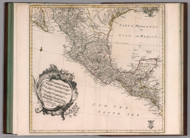
Full Title
Amerique Septentrionale : Par MM. Achille Meissas et Auguste Michelot. 1852. A la Librairie de L. Hachette. Grave sur acier par Dumortier, Ecrit par P.Rousset. Charle, del. (to accompany) Petit atlas universel de geographie Ancienne du Moyen Age et Moderne et de geographie sacree. (insets) Guadeloupe. (with) Martinique.
List No
11740.028
Note
2 colored in outline double page steel engraving map of North America. Showing the territories of 'MEXIQUE' and 'TEXAS', reflect the earlier situation before the Mexican-American War, and during the period of the Independent Republic of Texas. Political and administrative divisions, major cities, Indian territories, rivers and mountains are shown. Relief shown pictorially and by hachures.
Author
[Meissas, Achille, 1799-187, Michelot, Auguste Jean Charles, 1792-1854]
Full Title
Amerique Meridionale : Par MM. Achille Meissas et Auguste Michelot. 1854. A la Librairie de L. Hachette. Grave sur acier par Dumortier, Ecrit par P.Rousset. Charle, del. (to accompany) Petit atlas universel de geographie Ancienne du Moyen Age et Moderne et de geographie sacree. (insets) Guadeloupe. (with) Martinique.
List No
11740.029
Note
2 colored in outline double page steel engraving map of South America. Showing political divisions, major cities, rivers and mountains are shown. Relief shown by hachures.
Author
[Meissas, Achille, 1799-187, Michelot, Auguste Jean Charles, 1792-1854]
Full Title
Dispersion des hommes apres la confusion des Langues : Par MM. Achille Meissas et Auguste Michelot. 1841. A la Librairie de L. Hachette. Grave sur acier par Dumortier, Ecrit par P.Rousset. Charle, del. (to accompany) Petit atlas universel de geographie Ancienne du Moyen Age et Moderne et de geographie sacree. (inset) Paradis Terrestre.
List No
11740.030
Note
Colored in outline double page steel engraving map of Middle East. Includes color coded reference and table of Descendants de Noe. At upper margin: Atlas Complet No. 18 et 19.
Author
[Meissas, Achille, 1799-187, Michelot, Auguste Jean Charles, 1792-1854]
Full Title
Terre de Chanaan avant l' arrivee des Israelites. Par MM. Achille Meissas et Auguste Michelot. 1841. A la Librairie de L. Hachette. Grave sur acier par Dumortier, Ecrit par P.Rousset. Charle, del. (to accompany) Petit atlas universel de geographie Ancienne du Moyen Age et Moderne et de geographie sacree.
List No
11740.031
Note
Colored in outline double page steel engraving map of Holy Land. Shows settlements, routes, rivers, etc. Includes color coded reference. Relief shown by hachures and pictorially. At upper margin: Atlas Complet No. 20.
Author
[Meissas, Achille, 1799-187, Michelot, Auguste Jean Charles, 1792-1854]
Full Title
Route des Israelites dans desert : Par MM. Achille Meissas et Auguste Michelot. 1841. A la Librairie de L. Hachette. Grave sur acier par Dumortier, Ecrit par P.Rousset. Charle, del. (to accompany) Petit atlas universel de geographie Ancienne du Moyen Age et Moderne et de geographie sacree. (inset) Disposition du camp des Israelites.
List No
11740.032
Note
Colored in outline double page steel engraving map. Shows the routes of the Israelites through the desert, settlements, rivers, etc. Relief shown by hachures and pictorially. At upper margin: Atlas Complet No. 21.
Author
[Meissas, Achille, 1799-187, Michelot, Auguste Jean Charles, 1792-1854]
Full Title
Terre d'Israel divisee en 12 Tribus : Par MM. Achille Meissas et Auguste Michelot. 1841. A la Librairie de L. Hachette. Grave sur acier par Dumortier, Ecrit par P.Rousset. Charle, del. (to accompany) Petit atlas universel de geographie Ancienne du Moyen Age et Moderne et de geographie sacree.
List No
11740.033
Note
Colored in outline double page steel engraving map of the region covering present-day Israel and Jordan. Shows the Holy Land divided among the Twelve Tribes, the settlements, rivers, mountains, etc. Relief shown by hachures and pictorially. At upper margin: Atlas Complet No. 22.
Author
[Meissas, Achille, 1799-187, Michelot, Auguste Jean Charles, 1792-1854]
Full Title
Palestine en 4 provinces : Par MM. Achille Meissas et Auguste Michelot. 1841. A la Librairie de L. Hachette. Grave sur acier par Dumortier, Ecrit par P.Rousset. Charle, del. (to accompany) Petit atlas universel de geographie Ancienne du Moyen Age et Moderne et de geographie sacree. (inset) Plan de Jerusalem.
List No
11740.034
Note
Colored in outline double page steel engraving map of the 4 provinces of Palestine. Shows settlements, rivers, mountains, etc. Relief shown by hachures and pictorially. At upper margin: Atlas Complet No. 23 et 24.
Author
[Meissas, Achille, 1799-187, Michelot, Auguste Jean Charles, 1792-1854]
Full Title
Carte des voyages de St. Paul. Par MM. Achille Meissas et Auguste Michelot. 1841. A la Librairie de L. Hachette. Grave sur acier par Dumortier, Ecrit par P.Rousset. Charle, del. (to accompany) Petit atlas universel de geographie Ancienne du Moyen Age et Moderne et de geographie sacree.
List No
11740.035
Note
Colored in outline double page steel engraving map of Saint Paul missionary journeys. Shows routes, settlements, rivers, mountains, etc. Relief shown by hachures and pictorially. At upper margin: Atlas Complet No. 25.
Author
[Meissas, Achille, 1799-187, Michelot, Auguste Jean Charles, 1792-1854]
Full Title
Monde Connu Des Anciens. Par Meissas & Michelot. Dresse par Charle. Grave sur Acier par Moisy. Ecrit par Arnoul. (to accompany) Petit atlas universel de geographie Ancienne du Moyen Age et Moderne et de geographie sacree.
List No
11740.036
Note
Colored in outline double page steel engraving map of the ancient world from the Atlantic Ocean to Burma in Asia and from the Indian Ocean to the North Sea, including Asia, Europe and Africa. Shows political and administrative divisions, regions, major cities, rivers, mountains, etc. Relief shown by hachures and pictorially. At upper margin: Atlas Complet No. 26.
Author
[Meissas, Achille, 1799-187, Michelot, Auguste Jean Charles, 1792-1854]
Full Title
Europe Anciens. Par M M. Meissas & Michelot. Dresse par Charle. Grave sur Acier par Moisy. Ecrit par Arnoul. (to accompany) Petit atlas universel de geographie Ancienne du Moyen Age et Moderne et de geographie sacree.
List No
11740.037
Note
Colored in outline double page steel engraving map of ancient Europe. Shows political and administrative divisions, regions, major cities, rivers, mountains, etc. Relief shown by hachures and pictorially. At upper margin: Atlas Complet No. 27.
Author
[Meissas, Achille, 1799-187, Michelot, Auguste Jean Charles, 1792-1854]
Full Title
Iles Britanniques Anciens. (with) Germanie et Illyrie. Par M. M. Meissas et Michelot. Dresse par Charle. Grave sur Acier par Moisy. Ecrit par Arnoul. (to accompany) Petit atlas universel de geographie Ancienne du Moyen Age et Moderne et de geographie sacree.
List No
11740.038
Note
2 colored in outline double page steel engraving maps. Shows political and administrative divisions, regions, major cities, rivers, mountains, etc. Relief shown by hachures and pictorially. At upper margin: Atlas Complet Nos. 28 et 29.
Author
[Meissas, Achille, 1799-187, Michelot, Auguste Jean Charles, 1792-1854]
Full Title
Gaule : sous les Romaains. Par M. M. Meissas & Michelot. Dresse par Charle. Grave sur Acier par Moisy. Ecrit par Arnoul. (to accompany) Petit atlas universel de geographie Ancienne du Moyen Age et Moderne et de geographie sacree.
List No
11740.039
Note
Colored in outline double page steel engraving map of France under the Roman Empire. Shows administrative divisions, regions, major cities, rivers, mountains, etc. Relief shown by hachures and pictorially. At upper margin: Atlas Complet No. 30.
Author
[Meissas, Achille, 1799-187, Michelot, Auguste Jean Charles, 1792-1854]
Full Title
Espagne Ancienne. (with) Gaule Cisalpine. Par M. M. Meissas et Michelot. Dresse par Charle. Grave sur Acier par Moisy. Ecrit par Arnoul. (to accompany) Petit atlas universel de geographie Ancienne du Moyen Age et Moderne et de geographie sacree.
List No
11740.040
Note
2 colored in outline double page steel engraving maps of ancient Spain and Northern Italy. Shows political and administrative divisions, regions, major cities, rivers, mountains, etc. Relief shown by hachures and pictorially. At upper margin: Atlas Complet Nos. 31 et 32.
Author
[Meissas, Achille, 1799-187, Michelot, Auguste Jean Charles, 1792-1854]
Full Title
Italie Centrale et Grande Grece. Par M. M. Meissas et Michelot. Dresse par Charle. Grave sur Acier par Moisy. Ecrit par Arnoul. (to accompany) Petit atlas universel de geographie Ancienne du Moyen Age et Moderne et de geographie sacree.
List No
11740.041
Note
Colored in outline double page steel engraving map, with inset of regions in Central Italy. Shows political and administrative divisions, regions, major cities, rivers, mountains, etc. Relief shown by hachures and pictorially. At upper margin: Atlas Complet No. 33.
Author
[Meissas, Achille, 1799-187, Michelot, Auguste Jean Charles, 1792-1854]
Full Title
Grece. Par M. M. Meissas et Michelot. Dresse par Charle. Grave sur Acier par Moisy. Ecrit par Arnoul. (to accompany) Petit atlas universel de geographie Ancienne du Moyen Age et Moderne et de geographie sacree.
List No
11740.042
Note
Colored in outline double page steel engraving map of ancient Greece. Shows political and administrative divisions, regions, major cities, rivers, mountains, etc. Relief shown by hachures and pictorially. At upper margin: Atlas Complet No. 34.
Author
[Meissas, Achille, 1799-187, Michelot, Auguste Jean Charles, 1792-1854]
Full Title
Macedoine et Thrace. Par M. M. Meissas et Michelot. Partie de la Grece. Dresse par Charle. Grave sur Acier par Moisy. Ecrit par Arnoul. (to accompany) Petit atlas universel de geographie Ancienne du Moyen Age et Moderne et de geographie sacree.
List No
11740.043
Note
2 colored in outline double page steel engraving maps. Shows political and administrative divisions, regions, major cities, rivers, mountains, etc. Relief shown by hachures and pictorially. At upper margin: Atlas Complet Nos. 35 et 36.
Author
[Meissas, Achille, 1799-187, Michelot, Auguste Jean Charles, 1792-1854]
Full Title
Asie Mineure et Syrie Septle. Par M. M. Meissas et Michelot. (with) Asie Mineure : Partie Occidentale. Dresse par Charle. Grave sur Acier par Moisy. Ecrit par Arnoul. (to accompany) Petit atlas universel de geographie Ancienne du Moyen Age et Moderne et de geographie sacree.
List No
11740.044
Note
2 colored in outline double page steel engraving maps of Turkey and Northern Syria, on sheet 14x22. Scale 1:8,000,000 and Western Turkey, on sheet 22x14, Scale 1:3,700,000. Maps showing political and administrative divisions, regions, major cities, rivers, mountains, etc. Relief shown by hachures and pictorially. At upper margin: Atlas Complet Nos. 37 et 38.
Author
[Meissas, Achille, 1799-187, Michelot, Auguste Jean Charles, 1792-1854]
Full Title
Asie entre la mer interieure a l'Indes. Par M. M. Meissas et Michelot. Dresse par Charle. Grave sur Acier par Moisy. Ecrit par Arnoul. (to accompany) Petit atlas universel de geographie Ancienne du Moyen Age et Moderne et de geographie sacree.
List No
11740.045
Note
Colored in outline double page steel engraving map, from Mediterranean Sea to the Eritrean Sea. Showing political and administrative divisions, regions, major cities, rivers, mountains, etc. Relief shown by hachures. At upper margin: Atlas Complet No. 39.
Author
[Meissas, Achille, 1799-187, Michelot, Auguste Jean Charles, 1792-1854]
Full Title
Palestine. Par M. M. Meissas et Michelot. Dresse par Charle. Grave sur Acier par Moisy. Ecrit par Arnoul. (to accompany) Petit atlas universel de geographie Ancienne du Moyen Age et Moderne et de geographie sacree.
List No
11740.046
Note
Colored in outline double page steel engraving map of ancient Palestine with numerical key to the tribes. Showing political and administrative divisions, regions, major cities, rivers, mountains, etc. Relief shown by hachures. At upper margin: Atlas Complet No. 40.
Author
[Meissas, Achille, 1799-187, Michelot, Auguste Jean Charles, 1792-1854]
Full Title
Afrique, partie Nort Quest. (with) Egypt et Libya exterieure. Par M. M. Meissas & Michelot. Dresse par Charle. Grave sur Acier par Moisy. Ecrit par Arnoul. (to accompany) Petit atlas universel de geographie Ancienne du Moyen Age et Moderne et de geographie sacree. (inset) Delta basse Egypte.
List No
11740.047
Note
2 colored in outline double page steel engraving maps, with inset of Nile River Delta. Showing political and administrative divisions, regions, major cities, rivers, mountains, etc. Relief shown by hachures. At upper margin: Atlas Complet Nos. 41 et 42.
Author
[Meissas, Achille, 1799-187, Michelot, Auguste Jean Charles, 1792-1854]
Full Title
Empire d' Alexandre. Par M. M. Meissas et Michelot. 1844. A la Librairie de L. Hachette. Grave sur acier par Dumortier, Ecrit par P.Rousset. (to accompany) Petit atlas universel de geographie Ancienne du Moyen Age et Moderne et de geographie sacree.
List No
11740.048
Note
Colored in outline double page steel engraving map of Alexander's empire, with color code key. Showing political and administrative divisions, regions, major cities, rivers, mountains, etc. Relief shown by hachures and pictorially. At upper margin: Atlas Complet No. 43.
Author
[Meissas, Achille, 1799-187, Michelot, Auguste Jean Charles, 1792-1854]
Full Title
Empire Romain: a la mort de Constantin le Grand l'an 337. Par M. M. Achille Meissas et Auguste Michelot. 1844. A la Librairie de L. Hachette. Grave sur acier par Dumortier, Ecrit par P.Rousset. (to accompany) Petit atlas universel de geographie Ancienne du Moyen Age et Moderne et de geographie sacree.
List No
11740.049
Note
Colored in outline double page steel engraving map of Roman Empire. Showing political and administrative divisions, regions, major cities, rivers, mountains, etc. Relief shown by hachures and pictorially. At upper margin: Atlas Complet No. 44.
Author
[Meissas, Achille, 1799-187, Michelot, Auguste Jean Charles, 1792-1854]
Full Title
Europe, apres la conversion de Clovis : vers l'An 500. Par M. M. Achille Meissas et Auguste Michelot. 1841. A la Librairie de L. Hachette. Grave sur acier par Hte. Bonvalet. Ecrit par P. Rousset. Charle del. (to accompany) Petit atlas universel de geographie Ancienne du Moyen Age et Moderne et de geographie sacree.
List No
11740.050
Note
Colored double page steel engraving map of Europe after the conversion of Clovis, towards the year 500. Geographie du moyen age. Pl. 1. Showing political divisions, regions, major cities, rivers, mountains, etc. Relief shown by hachures and pictorially. At upper margin: Atlas Complet No. 43.
Author
[Meissas, Achille, 1799-187, Michelot, Auguste Jean Charles, 1792-1854]
Full Title
Europe vers l'An 600. Par M. M. Achille Meissas et Auguste Michelot. 1841. A la Librairie de L. Hachette. Grave sur acier par Hte. Bonvalet. Ecrit par P. Rousset. Charle del. (to accompany) Petit atlas universel de geographie Ancienne du Moyen Age et Moderne et de geographie sacree.
List No
11740.051
Note
Colored double page steel engraving map of Europe towards the Year 600. Geographie du moyen age. Pl. 2. Showing political divisions, regions, major cities, rivers, mountains, etc. Relief shown by hachures and pictorially. At upper margin: Atlas Complet No. 44.
Author
[Meissas, Achille, 1799-187, Michelot, Auguste Jean Charles, 1792-1854]
Full Title
Europe vers l'An 814. Par M. M. Achille Meissas et Auguste Michelot. 1841. A la Librairie de L. Hachette. Grave sur acier par Hte. Bonvalet. Ecrit par P. Rousset. Charle del. (to accompany) Petit atlas universel de geographie Ancienne du Moyen Age et Moderne et de geographie sacree.
List No
11740.052
Note
Colored double page steel engraving map of Europe towards the Year 814. Geographie du moyen age. Pl. 3. Showing political divisions, regions, major cities, rivers, mountains, etc. Relief shown by hachures and pictorially. At upper margin: Atlas Complet No. 45.
Author
[Meissas, Achille, 1799-187, Michelot, Auguste Jean Charles, 1792-1854]
Full Title
Europe vers l'An 1100, apres la 1ere, Croisad. Par M. M. Achille Meissas et Auguste Michelot. 1841. A la Librairie de L. Hachette. Grave sur acier par Hte. Bonvalet. Ecrit par P.Rousset. Charle del. (to accompany) Petit atlas universel de geographie Ancienne du Moyen Age et Moderne et de geographie sacree. (inset) Islande.
List No
11740.053
Note
Colored double page steel engraving map of Europe towards the Year 1,100, after the 1st, Crusade. Geographie du moyen age. Pl. 4. Showing political divisions, regions, major cities, rivers, mountains, etc. Relief shown by hachures and pictorially. At upper margin: Atlas Complet No. 46.
Author
[Meissas, Achille, 1799-187, Michelot, Auguste Jean Charles, 1792-1854]
Full Title
Europe vers l'An 1270, apres la mort de St. Louis. Par M. M. Achille Meissas et Auguste Michelot. 1841. A la Librairie de L. Hachette. Grave sur acier par Hte. Bonvalet. Ecrit par P.Rousset. Charle del. (to accompany) Petit atlas universel de geographie Ancienne du Moyen Age et Moderne et de geographie sacree.
List No
11740.054
Note
Colored double page steel engraving map of Europe towards the Year 1270, after the death of St. Louis. Geographie du moyen age. Pl. 5. Showing political divisions, regions, major cities, rivers, mountains, etc. Relief shown by hachures and pictorially. At upper margin: Atlas Complet No. 47.
Author
[Meissas, Achille, 1799-187, Michelot, Auguste Jean Charles, 1792-1854]
Full Title
Europe vers 1547, la mort de Francois 1er. Par M. M. Achille Meissas et Auguste Michelot. 1841. A la Librairie de L. Hachette. Grave sur acier par Dumortier, Ecrit par P.Rousset. Charle del. (to accompany) Petit atlas universel de geographie Ancienne du Moyen Age et Moderne et de geographie sacree.
List No
11740.055
Note
Colored double page steel engraving map of Europe around 1547, the death of Francois 1st. Geographie du moyen age. Pl. 6. Showing political divisions, regions, major cities, rivers, mountains, etc. Relief shown by hachures and pictorially. At upper margin: Atlas Complet No. 48.
Author
[Meissas, Achille, 1799-187, Michelot, Auguste Jean Charles, 1792-1854]
Full Title
Allemagne : Divisee en 10 Cercles. Pendant les 16e. 17e. et 18e. Siecles. Par M. M. Achille Meissas et Auguste Michelot. 1841. A la Librairie de L. Hachette. Grave sur acier par Hte. Bonvalet. Ecrit par P. Rousset. Charle del. (to accompany) Petit atlas universel de geographie Ancienne du Moyen Age et Moderne et de geographie sacree.
List No
11740.056
Note
Colored and outline double page steel engraving map of Germany's 10 Circle divisions, during the 16th. 17th. And 18th. centuries. Geographie du moyen age. Pl. 7. Showing administrative divisions, regions, major cities, rivers, mountains, etc. Relief shown by hachures and pictorially. At upper margin: Atlas Complet No. 49.
Author
[Meissas, Achille, 1799-187, Michelot, Auguste Jean Charles, 1792-1854]
Full Title
Gouvernements de la France : avec leurs principales Subdivisions avant 1789. Par M. M. Achille Meissas et Auguste Michelot. 1841. A la Librairie de L. Hachette. Grave sur acier par Dumortier. Ecrit par P.Rousset. Charle del. (to accompany) Petit atlas universel de geographie Ancienne du Moyen Age et Moderne et de geographie sacree. (inset) Corse.
List No
11740.057
Note
Colored and outline double page steel engraving map of France with subdivisions, before 1789. Geographie du moyen age. Pl. 8. Showing administrative divisions, regions, major cities, rivers, mountains, etc. Relief shown by hachures and pictorially. At upper margin: Atlas Complet No. 50.
Author
[Meissas, Achille, 1799-187, Michelot, Auguste Jean Charles, 1792-1854]
Full Title
Europe en 1789. Par M. M. Achille Meissas et Auguste Michelot. 1841. A la Librairie de L. Hachette. Grave sur acier par Dumortier. Ecrit par P.Rousset. Charle del. (to accompany) Petit atlas universel de geographie Ancienne du Moyen Age et Moderne et de geographie sacree. (inset) Corse.
List No
11740.058
Note
Colored and outline double page steel engraving map of Europe in 1789. Geographie du moyen age. Pl. 9. Showing political divisions, regions, major cities, rivers, mountains, etc. Relief shown by hachures and pictorially. At upper margin: Atlas Complet No. 51.
Author
[Meissas, Achille, 1799-187, Michelot, Auguste Jean Charles, 1792-1854]
Full Title
Empire Francais en 1812. Par M. M. Achille Meissas et Auguste Michelot. 1841. A la Librairie de L. Hachette. Grave sur acier par Dumortier. Ecrit par P.Rousset. Charle del. (to accompany) Petit atlas universel de geographie Ancienne du Moyen Age et Moderne et de geographie sacree.
List No
11740.059
Note
Colored and outline double page steel engraving map of French Empire in 1812. Geographie du moyen age. Pl. 10. Showing political and administrative divisions, regions, major cities, rivers, mountains, etc. Relief shown by hachures and pictorially. At upper margin: Atlas Complet No. 52.
Author
Lange, I. E.
Full Title
Die Erde in zwey halbkugeln. (to accompany) Neuer hand und elementar atlas ... Entworfen von I.E. Lange. Leipzig 1809.
List No
11945.004
Note
Engraved and hand painted with outline color, double Hemisphere map of the world. Color coded by continents. Relief shown by hachures. Includes explanation of colors.
Author
Lange, I. E.
Full Title
Charte von Europa : nach den neuesten astronomischen Ortsbestimmungen und berichtigungen entworfen. (to accompany) Neuer hand und elementar atlas ... Entworfen von I.E. Lange. Leipzig 1809.
List No
11945.005
Note
Engraved and hand painted with outline color map. Relief shown by hachures. Includes descriptive text on lower panel.
Author
Lange, I. E.
Full Title
Charte von Asien : nach den neuesten und besten Hulfsmitteln entworfen. (to accompany) Neuer hand und elementar atlas ... Entworfen von I.E. Lange. Leipzig 1809.
List No
11945.006
Note
Engraved and hand painted with outline color map. Relief shown by hachures. Prime meridians are Ferro and Paris. Includes descriptive text on lower panel.
Author
Lange, I. E.
Full Title
Charte von Afrika : nach den neuesten berichtigungen und Ortsbestimmungen entworfen. (to accompany) Neuer hand und elementar atlas ... Entworfen von I.E. Lange. Leipzig 1809.
List No
11945.007
Note
Engraved and hand painted with outline color map. Relief shown by hachures. Prime meridian is Ferro.
Author
Lange, I. E.
Full Title
Charte von Nord - Amerika. (to accompany) Neuer hand und elementar atlas ... Entworfen von I.E. Lange. Leipzig 1809.
List No
11945.008
Note
Engraved and hand painted with outline color map. Shows political and state boundaries, major cities, rivers and mountains. Relief shown by hachures. Includes extensive annotations on names and dates of early explorers.
Author
Lange, I. E.
Full Title
Sud - Amerika. (to accompany) Neuer hand und elementar atlas ... Entworfen von I.E. Lange. Leipzig 1809.
List No
11945.009
Note
Engraved and hand painted with outline color map. Shows political boundaries, major cities, rivers and mountains. Relief shown by hachures. Prime meridian is Ferro. Includes descriptive text on lower panel.
Author
Lange, I. E.
Full Title
Charte von Australien oder Polynesien : nach den Zeichnungen, Reisebe Schreibungen und Tagebucher der vorzuglichsten Seefahrere entworffen im Jahr 1809. (to accompany) Neuer hand und elementar atlas ... Entworfen von I.E. Lange. Leipzig 1809.
List No
11945.010
Note
Engraved and hand painted with outline color map. Shows political boundaries, major cities, rivers and mountains. Relief shown by hachures. Prime meridian is Greenwich.Includes extensive annotations on coastlines of Australia, including the names and dates of early explorers.
Author
Lange, I. E.
Full Title
Charte von Arabien : nach den neuesten und besten Hulfsmitteln entworfen. (to accompany) Neuer hand und elementar atlas ... Entworfen von I.E. Lange. Leipzig 1809.
List No
11945.011
Note
Engraved and hand painted with outline color map. Shows political boundaries, major cities, rivers and mountains. Relief shown by hachures. Includes descriptive text.
Author
Lange, I. E.
Full Title
Charte von Europaoschen und Asiatischen Turkey : oder dem Oschmanischen Reiche. (to accompany) Neuer hand und elementar atlas ... Entworfen von I.E. Lange. Leipzig 1809.
List No
11945.012
Note
Engraved and hand painted with outline color map. Shows political boundaries, major cities, rivers and mountains. Relief shown by hachures. Includes descriptive text. Prime meridian is Ferro.
Author
Lange, I. E.
Full Title
Charte von Ost und West Perssien : oder dem landern des Kurdischen Stams Kerim und des von Achmed - abdallis in Candahar. (to accompany) Neuer hand und elementar atlas ... Entworfen von I.E. Lange. Leipzig 1809.
List No
11945.013
Note
Engraved and hand painted with outline color map. Shows political boundaries, major cities, rivers and mountains. Relief shown by hachures. Includes descriptive text. Prime meridian is Ferro.
Author
Lange, I. E.
Full Title
Karte von Ost Indien ostlicher theil : oder hinter - Indien als, Ava, Pegu, Siam, Ascham, Malacca, Tunkin, Camboja, nebst den Sundischen Inseln Java, Sumatra, etc. (to accompany) Neuer hand und elementar atlas ... Entworfen von I.E. Lange. Leipzig 1809.
List No
11945.014
Note
Engraved and hand painted with outline color map. Shows political boundaries, major cities, rivers and mountains. Relief shown by hachures. Includes descriptive text on lower panel.
Author
Lange, I. E.
Full Title
Charte von Ost - Indien westlicher theil : oder Vorder Indien welches die besitzungen der Europaer Bengalen oder das Reich der Britten die Lander der Seiks Maratten Sultans, Tippos Lander u.s.s. enthalt. (to accompany) Neuer hand und elementar atlas ... Entworfen von I.E. Lange. Leipzig 1809.
List No
11945.015
Note
Engraved and hand painted with outline color map. Shows administrative boundaries, major cities, rivers and mountains. Relief shown by hachures. Includes descriptive text on lower panel. Prime meridian is Ferro.
Author
Lange, I. E.
Full Title
Charte von Niphon : oder Iapan nebst der von China abhangigen halbsinsel Korea und den Amurlande oder der Mantschurey. (to accompany) Neuer hand und elementar atlas ... Entworfen von I.E. Lange. Leipzig 1809.
List No
11945.016
Note
Engraved and hand painted with outline color map. Shows administrative boundaries, major cities, rivers and mountains. Relief shown by hachures. Includes descriptive text. Prime meridian is Ferro.
Author
Lange, I. E.
Full Title
Das Asiatische Rusland welches Ost -und- West Siberien enthalt. (to accompany) Neuer hand und elementar atlas ... Entworfen von I.E. Lange. Leipzig 1809.
List No
11945.017
Note
Engraved and hand painted with outline color map. Shows boundaries, major cities, rivers and mountains. Relief shown by hachures. Includes descriptive text on lower panel.
Author
Lange, I. E.
Full Title
Charte von China. (to accompany) Neuer hand und elementar atlas ... Entworfen von I.E. Lange. Leipzig 1809.
List No
11945.018
Note
Engraved and hand painted with outline color map. Shows boundaries, major cities, rivers and mountains. Relief shown by hachures. Includes descriptive text on lower panel.
Author
Lange, I. E.
Full Title
Charte von der vereinigten Staaten von Nord-America die vereinigten provinzen von N. Amerika, Neuhampshire, Massachusetsbay, Conecticut, rhodeisland, Newyork, Newjersey, Pensylvanien, Delaware, Maryland, Virginien, N.u. S. Carolina, Georgien, enthalten 35,000 quadr. Meilen, mit 9 Milion Menschen. (to accompany) Neuer hand und elementar atlas ... Entworfen von I.E. Lange. Leipzig 1809.
List No
11945.019
Note
Engraved and hand painted with outline color map of the United States provinces, including New Hampshire, Massachusets Bay, Conecticut, Rhode Island, New York, New Jersey, Pennsylvania, Delaware, Maryland, Virginia, N. and S. Carolina, Georgia, part of Florida and Canada. Contains 35,000 quadr. Miles, with 9 million people. Shows state boundaries, major cities, rivers and mountains. Relief shown by hachures. Prime meridian is London.
Author
Lange, I. E.
Full Title
Karte von den Franzosisch Illyrischen provinzen, welche in Wiener Frieden 1809 an Frankreich uberlassen sind. (to accompany) Neuer hand und elementar atlas ... Entworfen von I.E. Lange. Leipzig 1809.
List No
11945.020
Note
Engraved and hand painted with outline color map of the Illyrian provinces, north and east coasts of the Adriatic Sea region. Shows political boundaries, major cities, rivers and mountains. Relief shown by hachures.
Author
Vuillemin, A.
Full Title
Planisphere Indiquant les Decouvertes Maritimes & Continentales, Les Colonies Europeennes. (insets) (Various port cities, the Antillles, Panama).
List No
12051.002
Author
Bouvard
Full Title
Uranographie ... Astronomie.
List No
12051.003
Author
Logerot, A.
Full Title
Carte de Generale de l'Europe.
List No
12051.004
Author
Logerot, Aug.
Full Title
Nouveau Plan de Paris Divisee en 20 Arrondissements.
List No
12051.005
Author
[Logerot, Aug., Donnet, Alexis]
Full Title
Environs de Paris.
List No
12051.006
Author
[Coutant, E., Feret et Fils]
Full Title
Carte Routiere et Vinicole Departement de la Gironde ... Pour accompagner l'ouverage intitule Bordeaux et ses Vins.
List No
12051.007
Author
Locerot, A.
Full Title
Plan Officiel de le Ville du Havre (western sheet).
List No
12051.008
Note
Includes list of public places, keyed to map. Date estimated.
Author
Locerot, A.
Full Title
Plan Officiel de le Ville du Havre (eastern sheet).
List No
12051.009
Note
Includes list of public places, keyed to map. Date estimated.
Author
E. Laprou et Greffier
Full Title
Fabriques de Sucre et Principales Distilleries. Carte de Fabriques de Sucre du Nord de la France et de la Belgique.
List No
12051.011
Note
Foldout. Has lengthy list of processing facilities, keyed to map.
Author
Vuillemin, A.
Full Title
Nouveau Planisphere Mappe Monde Elementaire a l'Usage des Ecoles Primaires.
List No
12051.012
Author
Vuillemin, A.
Full Title
Mappe Monde Elementaire a l'Usage des Ecoles Primaires.
List No
12051.013
Note
Foldout.
Author
Vuillemin, A.
Full Title
Nouvelle Elementaire de l'Europe a l'Usage des Ecoles Primaires.
List No
12051.014
Author
Vuillemin, A.
Full Title
Nouvelle Carte Elementaire de la France a l'Usage des Ecoles Primaires.
List No
12051.015
Author
Logerot, A.
Full Title
Nouvelle Carte Elementaire de l'Asie Nouvelle Carte de l'Afrique a l'Usage des Ecoles Primaires.
List No
12051.016
Author
Vuillemin, A.
Full Title
Nouvelle Carte de l'Afrique a l'Usage des Ecoles Primaires.
List No
12051.017
Author
Logerot, A.
Full Title
Nouvelle Carte Elementaire de L'Amerique du Nord a l'Usage des Ecoles. Nouvelle Carte Elementaire de L'Amerique du Sud a l'Usage des Ecoles.
List No
12051.018
Author
Vuillemin, A.
Full Title
Nouvelle Carte Elementaire de L'Oceanie a l'Usage des Ecoles Primaires.
List No
12051.019
Author
Logerot, Augte.
Full Title
Nouvelle Carte de la Palestine ou Terre-Sainte a L'Usage de Ecoles Primaires. (insets) Plan de Jerusalem. Carte des Pays traverses par les Hebreux sous la conduite de Moise.
List No
12051.020
Author
Vuillemin, A.
Full Title
Nouvelle Carte du Departement du Rhone a L'Usage de Ecoles Primaires.
List No
12051.021
Author
[Bonnamas, Ln., Logerot, A., Queuilhe, Clle.]
Full Title
Nouvelle Carte du Departement de la Cote d'Or a L'Usage de Ecoles Primaires. (inset) Plan de Dijon de ses Environs.
List No
12051.022
Author
Mariotti, M.L.
Full Title
Carte du Departement de L'Aisne Specialement Destinee aux Ecoles Primares.
List No
12051.023
Note
Foldout.
Author
Vuillemin, A.
Full Title
Nouvelle Carte du Departement de la Marne a L'Usage de Ecoles Primaires.
List No
12051.024
Author
Vuillemin, A.
Full Title
Nouvelle Carte du Departement du Loiret a L'Usage des Commercants.
List No
12051.025
Author
Vuillemin, A.
Full Title
Nouvelle Carte du Departement de L'Isere a L'Usage de Ecoles Primaires.
List No
12051.026
Author
Langlois, Achille
Full Title
Nouvelle Carte du Departement de Saone et Loire Dressee d'Apres de Carte du Dept de La Guerre. (inset) Macon.
List No
12051.027
Author
[Dubois, F.E., Vuillemin, A., Erhard]
Full Title
Carte de L'Ile d'Haiti ... L'Enseignement de la Jeunesse Haitienne. (inset) Plan de la Port-au-Prince.
List No
12051.029
Author
Palairet, Jean
Full Title
1e. Le Mappe Monde.
List No
12055.007
Note
Date estimated based on rest of atlas.
Author
Palairet, Jean
Full Title
2e. Le Mappe Monde. 1754.
List No
12055.008
Author
Palairet, Jean
Full Title
3e. Le Mappe Monde. 1755.
List No
12055.009
Author
Palairet, Jean
Full Title
I. Carte de l'Europe. 1754.
List No
12055.010
Author
Palairet, Jean
Full Title
II. Carte de l'Europe. 1754.
List No
12055.011
Author
Palairet, Jean
Full Title
III. Carte de l'Europe. 1754.
List No
12055.012
Author
[Declarochette, L., Palairet, Jean]
Full Title
A Map of Europe Divided into its Empires, Kingdoms, etc.
List No
12055.013
Note
Date estimated based on rest of atlas.
Author
Palairet, Jean
Full Title
1e .Carte de l'Asie. 1754.
List No
12055.014
Author
[Palairet, Jean, Delarochette, L.]
Full Title
A Map of Asia with its Principal Divisions.
List No
12055.015
Note
Date estimated based on rest of atlas.
Author
Palairet, Jean
Full Title
Ie. Carte d'Afrique. 1754.
List No
12055.016
Author
Palairet, Jean
Full Title
2e. Carte d'Afrique. 1754.
List No
12055.017
Author
Palairet, Jean
Full Title
Carte Generale de l'Amerique 1754.
List No
12055.018
Author
Palairet, Jean
Full Title
Carte de l'Amerique Septentrionle 1754.
List No
12055.019
Author
[De Larochette, D'Anville]
Full Title
South America from the Latest Discoveries, Shewing the Spanish & Portuguese Settlements according to Mr. D. Anville. By De Larochette.
List No
12055.021
Note
Date estimated based on rest of atlas. "London printed for J. Bowles in St. Pauls Church Yard."
Author
Palairet, Jean
Full Title
1e. Carte d'Angleterre. 1754.
List No
12055.022
Author
Palairet, Jean
Full Title
2e. Carte d'Angleterre. 1754.
List No
12055.023
Author
Rocque, John
Full Title
A New Map of England and Wales ... by John Rocque. 1760.
List No
12055.024
Author
Palairet, Jean
Full Title
1e. Carte d'Ecosse. 1754.
List No
12055.025
Author
Dorret, James
Full Title
A Correct Map of Scotland. (inset) Shetland Islands.
List No
12055.026
Note
Foldout. Date estimated based on rest of atlas.
Author
Palairet, Jean
Full Title
Ie. Carte d'Irelande 1754.
List No
12055.027
Author
Jefferys, Thomas
Full Title
A New and Accurate Map of the Kingdom of Ireland.
List No
12055.028
Author
Palairet, Jean
Full Title
Carte de Danemark.
List No
12055.029
Author
Palairet, Jean
Full Title
Carte de Norwege & 1e. de Suede. 1755.
List No
12055.030
Author
Palairet, Jean
Full Title
Carte de Norwege & 2e. de Suede. 1755.
List No
12055.031
Author
Palairet, Jean
Full Title
1e. Carte de l'Empire de Russie en Europe. 1755.
List No
12055.032
Author
Palairet, Jean
Full Title
2e. Carte de l'Empire de Russie en Europe. 1755.
List No
12055.033
Author
Palairet, Jean
Full Title
Ie. Carte de France. 1754.
List No
12055.034
Author
Palairet, Jean
Full Title
2e. Carte de France. 1754.
List No
12055.035
Author
Palairet, Jean
Full Title
IIIe. Carte de France. 1754.
List No
12055.036
Author
Palairet, Jean
Full Title
Ie. Carte des Sept Provinces Unies des Pais Bas &c.
List No
12055.037
Note
Date estimated based on rest of atlas.
Author
Palairet, Jean
Full Title
2e. Carte des Sept Provinces Unies des Pais Bas &c.
List No
12055.038
Note
Date estimated based on rest of atlas.
Author
Palairet, Jean
Full Title
Ie. Carte des Pais-Bas Catholiques. 1755.
List No
12055.039
Author
Palairet, Jean
Full Title
2e. Carte des Pais-Bas Catholiques. 1755.
List No
12055.040
Author
Palairet, Jean
Full Title
1e. Carte de Suisse. 1755.
List No
12055.041
Author
Rocque, John
Full Title
Carte de Suisse.
List No
12055.042
Author
Palairet, Jean
Full Title
1e. Carte d'Allemagne. 1755.
List No
12055.043
Author
Palairet, Jean
Full Title
2e. Carte d'Allemagne. 1755.
List No
12055.044
Author
Palairet, Jean
Full Title
3e. Carte d'Allemagne. 1755.
List No
12055.045
Author
Palairet, Jean
Full Title
Ie. Carte de Pologne. 1755.
List No
12055.046
Author
Mayer, Tobias, 1723-1762
Full Title
Map of the Kingdom of Poland and the Grand Dutchy of Lithuania.
List No
12055.047
Author
Palairet, Jean
Full Title
Ie. Carte de Hongrie. 1755.
List No
12055.048
Author
Palairet, Jean
Full Title
2e. Carte de Hongrie. 1755.
List No
12055.049
Author
Palairet, Jean
Full Title
Ie. Carte d'Espagne. 1755.
List No
12055.050
Author
Palairet, Jean
Full Title
2e. Carte d'Espagne & Ie. de Portugal. 1755.
List No
12055.051
Author
Palairet, Jean
Full Title
3e. Carte d'Espagne & Ie. de Portugal. 1755.
List No
12055.052
Author
Palairet, Jean
Full Title
Ie. Carte de la Turquie Europeenne. 1755.
List No
12055.053
Author
Palairet, Jean
Full Title
2e. Carte de la Turquie Europeenne. 1755.
List No
12055.054
Author
Palairet, Jean
Full Title
Ie. Carte de la Judee or Terre Sainte divisee en ses douze Tribus. (inset) Ie. Carte du Pais de Canaan.
List No
12055.055
Author
Roberts
Full Title
A Map of the Land of Canaan or Holy Land as divided Among the Twelve Tribes.
List No
12055.056
Author
Palairet, Jean
Full Title
Ie. Carte d'Italie. 1755.
List No
12055.057
Author
Palairet, Jean
Full Title
2e. Carte d'Italie. 1755.
List No
12055.058
Author
[Delarochette, L., Palairet, Jean]
Full Title
A Map of Italy.
List No
12055.059
Author
Homann, Johann Baptist, 1663-1724
Full Title
Europa.
List No
12138.005
Author
Homann, Johann Baptist, 1663-1724
Full Title
Imperii Romano-Germanici.
List No
12138.006
Author
Homann, Johann Baptist, 1663-1724
Full Title
Regni Bohemiae.
List No
12138.007
Author
Homann, Johann Baptist, 1663-1724
Full Title
Circulus Austriacus.
List No
12138.008
Author
Homann, Johann Baptist, 1663-1724
Full Title
S.R.I. Circulus Rhenanus Inferior sive Electorum Rheni.
List No
12138.009
Author
Homann, Johann Baptist, 1663-1724
Full Title
Circuli supe Saxoniae pars Meridionales.
List No
12138.010
Author
Homann, Johann Baptist, 1663-1724
Full Title
Tabula Marchionatus Brandenburgici et Ducatus Pomeraniae.
List No
12138.011
Author
Homann, Johann Baptist, 1663-1724
Full Title
Circuli Franconiae.
List No
12138.012
Author
Homann, Johann Baptist, 1663-1724
Full Title
Bavariae.
List No
12138.013
Author
Homann, Johann Baptist, 1663-1724
Full Title
Circuli Sueviae.
List No
12138.014
Author
Homann, Johann Baptist, 1663-1724
Full Title
S.R.I. Cirulus Rhenanus Superior.
List No
12138.015
Author
Homann, Johann Baptist, 1663-1724
Full Title
Circuli Westphaliae.
List No
12138.016
Author
Homann, Johann Baptist, 1663-1724
Full Title
Circulus Saxoniae Inferioris.
List No
12138.017
Author
Homann, Johann Baptist, 1663-1724
Full Title
Belgii Universi.
List No
12138.018
Author
Homann, Johann Baptist, 1663-1724
Full Title
Belgium Catholicum seu Decem Provinciae.
List No
12138.019
Author
Homann, Johann Baptist, 1663-1724
Full Title
Septem Provinciae Belgium Foederatum.
List No
12138.020
Author
Homann, Johann Baptist, 1663-1724
Full Title
Helvetia.
List No
12138.021
Author
Homann, Johann Baptist, 1663-1724
Full Title
Regni Galliae seu Franciae et Navarrae.
List No
12138.022
Author
Homann, Johann Baptist, 1663-1724
Full Title
Italia.
List No
12138.023
|