|
Author
Stanford, Edward
Full Title
The World
List No
15996.004
Note
Date estimated.
Author
Stanford, Edward
Full Title
Eastern Hemisphere
List No
15996.005
Note
Date estimated.
Author
Stanford, Edward
Full Title
Western Hemisphere
List No
15996.006
Note
Date estimated.
Author
Stanford, Edward
Full Title
England
List No
15996.008
Note
Date estimated.
Author
Stanford, Edward
Full Title
Scotland
List No
15996.009
Note
Date estimated.
Author
Stanford, Edward
Full Title
Ireland
List No
15996.010
Note
Date estimated.
Author
Stanford, Edward
Full Title
Australia
List No
15996.020
Note
Date estimated.
Author
Stanford, Edward
Full Title
New Zealand
List No
15996.021
Note
Date estimated.
Author
Logerot, A. (Auguste)
Full Title
[Map of Europe.] Ce 8 8bre 1856 ; A. Logerot.
List No
14489.003
Note
Manuscript map representing Europe. Shows select regions, mountain ranges, drainage, coastlines, and islands. Relief shown with hachure lines and shading. Indexed to indicate the names of mountain ranges. Ink, pencil, and watercolor on paper. Indexed to indicate locations such as the Tyrolean Alps and Saint-Gotthard Massif. Map is 24 x 30 cm, on sheet 24 x 32 cm.
Author
Logerot, A. (Auguste)
Full Title
[Map of Europe.] Ce 15 8bre 1856 ; A. Logerot.
List No
14489.004
Note
Manuscript map representing Europe. Shows select regions, cities, mountain ranges, drainage, coastlines, and islands. Relief shown with shading. Features watershed areas, which are differentiated by color. Indexed to indicate the names of mountains and lakes. Ink, pencil, and watercolor on paper. Map is 24 x 30 cm, on sheet 24 x 32 cm.
Author
Logerot, A. (Auguste)
Full Title
Mer Blanche. Ce 23 8bre 1856 ; A. Logerot.
List No
14489.005
Note
Manuscript map representing the White Sea. Shows select regions, cities, mountain ranges, drainage, coastlines, and islands. Relief shown with shading. Ink, pencil, and watercolor on paper. Map is 24 x 30 cm, on sheet 24 x 32 cm.
Author
Logerot, A. (Auguste)
Full Title
Rhin Suisse. Ce 18 Fevrier 1857 ; A. Logerot.
List No
14489.015
Note
Manuscript map representing the watershed of the Rhine River in Switzerland. Shows select regions, cities, mountain ranges, drainage, and bodies of water. Relief shown with shading. Ink, pencil, and watercolor on paper. Map is 22 x 28 cm, on sheet 24 x 31 cm.
Author
Logerot, A. (Auguste)
Full Title
[France.] A. Logerot.
List No
14489.021
Note
Manuscript map representing France. Shows select regions, mountain ranges, drainage, coastlines, and islands. Relief shown with shading. Ink, pencil, and watercolor on paper. Map is 23 x 29 cm, on sheet 24 x 31 cm.
Author
Logerot, A. (Auguste)
Full Title
[Armorican Massif, France.] Ce 98 Mai 1857 ; A. Logerot.
List No
14489.025
Note
Manuscript map representing the Armorican Massif in France. Shows select regions, cities, mountain ranges, drainage, coastlines, and islands. Relief shown with shading. Ink, pencil, and watercolor on paper. Map is 21 x 29 cm, on sheet 24 x 31 cm.
Author
Logerot, A. (Auguste)
Full Title
[Loire River.] A. Logerot.
List No
14489.026
Note
Manuscript map representing the Loire River basin in France. Shows select regions, cities, mountain ranges, drainage, coastlines, and islands. Relief shown with shading. Ink, pencil, and watercolor on paper. Map is 23 x 30 cm, on sheet 23 x 30 cm.
Author
Logerot, A. (Auguste)
Full Title
[Loire River.] A. Logerot.
List No
14489.027
Note
Manuscript map representing the Loire River basin in France. Shows select regions, cities, mountain ranges, drainage, coastlines, and islands. Relief shown with shading. Ink, pencil, and watercolor on paper. Map is 23 x 29 cm, on sheet 23 x 30 cm.
Author
Logerot, A. (Auguste)
Full Title
Asie mineure. A. Logerot.
List No
14489.038
Note
Manuscript map representing Asia Minor. Shows select regions, cities, mountain ranges, drainage, coastlines, and islands. Relief shown with shading. Ink, pencil, and watercolor on paper. Map is 21 x 27 cm, on sheet 24 x 31 cm.
Author
Logerot, A. (Auguste)
Full Title
Afrique. A. Logerot ; Ce 8 Janvier 1856.
List No
14489.041
Note
Manuscript map representing Africa. Shows select regions, cities, mountain ranges, deserts, drainage, coastlines, and islands. Relief shown with shading. Ink, pencil, and watercolor on paper. Map is 22 x 28 cm, on sheet 24 x 31 cm. (Page number written as “43” for page 44 in volume.)
Author
Logerot, A. (Auguste)
Full Title
Amerique du Noro. A. Logerot.
List No
14489.042
Note
Manuscript map representing North America. Shows select regions, mountain ranges, coastlines, and islands. Ink, pencil, and watercolor on paper. Map is 30 x 23 cm, on sheet 30 x 23 cm.
Author
Logerot, A. (Auguste)
Full Title
Amérique Septentrionale. A. Logerot.
List No
14489.043
Note
Manuscript map representing North America. Shows select regions, mountain ranges, drainage, bodies of water, coastlines, and islands. Relief shown with shading. Ink, pencil, and watercolor on paper. Map is 27 x 23 cm, on sheet 31 x 23 cm.
Author
Logerot, A. (Auguste)
Full Title
[North and South America.] A. Logerot.
List No
14489.044
Note
Manuscript map representing North and South America. Shows select regions, mountain ranges, drainage, bodies of water, coastlines, and islands. Relief shown with shading. Ink, pencil, and watercolor on paper. Map is 31 x 23 cm, on sheet 31 x 23 cm.
Author
Logerot, A. (Auguste)
Full Title
[South America.] A. Logerot.
List No
14489.045
Note
Manuscript map representing South America. Shows select regions, mountain ranges, drainage, coastlines, and islands. Relief shown with shading. Ink, pencil, and watercolor on paper. Map is 22 x 28 cm, on sheet 30 x 23 cm.
Author
Logerot, A. (Auguste)
Full Title
Océanie. A. Logerot.
List No
14489.046
Note
Manuscript map representing Oceania. Shows select regions, cities, mountain ranges, drainage, coastlines, and islands. Relief shown with shading. Ink, pencil, and watercolor on paper. Map is 22 x 28 cm, on sheet 24 x 30 cm.
Author
[Sutnar, Ladislav, Tschinkel, Augustin]
Full Title
Naše republika (Our Country)
List No
15867.003
Author
[Sutnar, Ladislav, Tschinkel, Augustin]
Full Title
Hory a Feky (Mountains and Rivers) (with) Lesy a lázne (Forests and Land)
List No
15867.004
Author
[Sutnar, Ladislav, Tschinkel, Augustin]
Full Title
Železnice (Railways) (with) Národnosti (Nationalities)
List No
15867.005
Author
[Sutnar, Ladislav, Tschinkel, Augustin]
Full Title
Minulest (The Past) (with) Naše země v 9. a 10. století (Our country in the 9th and 10th centuries)
List No
15867.006
Author
[Sutnar, Ladislav, Tschinkel, Augustin]
Full Title
Ríše Přemysla II. Otakara (The Empire of Přemysl II Otakara) (with) Ríše Václava lI. a Václava IIl. (The Empire of Wenceslas I. and Wenceslas III)
List No
15867.007
Author
[Sutnar, Ladislav, Tschinkel, Augustin]
Full Title
Riše Karlova (Karlova's Empire) (with) Rakousko-Uhersko (Austria Hungary)
List No
15867.008
Author
[Sutnar, Ladislav, Tschinkel, Augustin]
Full Title
Boj za svobodu (The Fight for Freedom) (with) Vznik Československé republiky (Emergence of the Czechoslovak Republic)
List No
15867.009
Author
[Sutnar, Ladislav, Tschinkel, Augustin]
Full Title
Přítomnost (Presence) (with) Obyvatelstvo podle národnosti (Population by Nationality)
List No
15867.010
Author
[Sutnar, Ladislav, Tschinkel, Augustin]
Full Title
Domácí zvířata (Domestic Animals) (with) Uhelné pánve a oblasti textilního průmyslu (Coal basins and textile industry areas)
List No
15867.013
Author
[Sutnar, Ladislav, Tschinkel, Augustin]
Full Title
Praha (Prague) (with) Počet obyvatelstva Prahy (Population of Prague) Praha asi roku 1400 (Prague around 1400) (and) Praha dnešní (Today's Prague)
List No
15867.016
Author
[Ravenstein, August, Berlin Geographisch-Artistische Anstalt Ernst Schotte]
Full Title
Karten-Ideal zur elementaren Darstellung der topischen Verhältnisse von Wasser und Land auf dem Erdboden, nebst der Oestl. & Westl. Erdhälfte, zur Erläuterung mathemat. eintheilung u. physisch-geograph. Verhältnisse. Zeichnung u. Modell von August Ravenstein in Frankfurt a. M. Stich, Prägung, Druck u. Verlag von B. Dondorf in Frankfurt a. M.
List No
14473.003
Note
Relief map of the world, shown as the Western and Eastern Hemispheres, as well as a closer view of the Netherlands and vicinity. Shows geographical regions, topography, vegetation, bodies of water, drainage, coastlines, shoals and islands. Topography shown with raised relief. Includes latitudinal and longitudinal lines, as well as descriptive notes. Legend for map appears on title page. Colored lithograph. Map is 22 x 27 cm, within frame 24 x 28 cm. Within a series of eight maps comprising the school atlas, Plastischer Schul-Atlas.
Author
[Ravenstein, August, Berlin Geographisch-Artistische Anstalt Ernst Schotte]
Full Title
Deutschland nebst den Königreichen Holland, Belgien und der Republik Schweiz. Zeichnung u. Modell von August Ravenstein in Frankfurt a. M. Stich, Prägung, Druck u. Verlag von B. Dondorf in Frankfurt a. M.
List No
14473.004
Note
Relief map of Germany, the Netherlands, Belgium and Switzerland. Shows geographical regions, countries, cities, railways, canals, topography, vegetation, bodies of water, drainage, coastlines, shoals and islands. Topography shown with raised relief. Includes a legend, bar scale given in miles, latitudinal and longitudinal lines, as well as statistical and descriptive notes. Additional legend for map appears on title page. Colored lithograph. Map is 22 x 27 cm, within frame 24 x 28 cm. Within a series of eight maps comprising the school atlas, Plastischer Schul-Atlas.
Author
[Ravenstein, August, Berlin Geographisch-Artistische Anstalt Ernst Schotte]
Full Title
Europa. Zeichnung u. Modell von August Ravenstein in Frankfurt a. M. Stich, Prägung, Druck u. Verlag von B. Dondorf in Frankfurt a. M.
List No
14473.005
Note
Relief map of Europe. Shows geographical regions, countries, cities, railways, topography, vegetation, bodies of water, drainage, coastlines, shoals and islands. Topography shown with raised relief. Includes a legend, bar scale given in miles, latitudinal and longitudinal lines, as well as statistical and descriptive notes. Additional legend for map appears on title page. With a vignette of scenery, figures, fauna and flora. Colored lithograph. Map is 22 x 27 cm, within frame 24 x 28 cm. Within a series of eight maps comprising the school atlas, Plastischer Schul-Atlas.
Author
[Ravenstein, August, Berlin Geographisch-Artistische Anstalt Ernst Schotte]
Full Title
Asien. Zeichnung u. Modell von August Ravenstein in Frankfurt a. M. Stich, Prägung, Druck u. Verlag von B. Dondorf in Frankfurt a. M.
List No
14473.006
Note
Relief map of Asia. Shows geographical regions, countries, cities, railways, topography, vegetation, bodies of water, drainage, coastlines, shoals and islands. Topography shown with raised relief. Includes a legend, bar scale given in miles, latitudinal and longitudinal lines, as well as statistical and descriptive notes. Additional legend for map appears on title page. With an indexed vignette of scenery, indigenous figures, fauna and flora. Colored lithograph. Map is 22 x 27 cm, within frame 24 x 28 cm. Within a series of eight maps comprising the school atlas, Plastischer Schul-Atlas.
Author
[Ravenstein, August, Berlin Geographisch-Artistische Anstalt Ernst Schotte]
Full Title
Nord-u. Mittel-Amerika. Zeichnung u. Modell von August Ravenstein in Frankfurt a. M. Stich, Prägung, Druck u. Verlag von B. Dondorf in Frankfurt a. M.
List No
14473.007
Note
Relief map of North and Central America. Shows geographical regions, countries, cities, railways, topography, vegetation, bodies of water, drainage, coastlines, shoals and islands. Topography shown with raised relief. Includes a legend, bar scale given in miles, latitudinal and longitudinal lines, as well as statistical and descriptive notes. Additional legend for map appears on title page. With an indexed vignette of scenery, figures, fauna and flora. Colored lithograph. Map is 27 x 22 cm, within frame 28 x 24 cm. Within a series of eight maps comprising the school atlas, Plastischer Schul-Atlas.
Author
[Ravenstein, August, Berlin Geographisch-Artistische Anstalt Ernst Schotte]
Full Title
Südamerika. Zeichnung u. Modell von August Ravenstein in Frankfurt a. M. Stich, Prägung, Druck u. Verlag von B. Dondorf in Frankfurt a. M.
List No
14473.008
Note
Relief map of South America. Shows geographical regions, countries, cities, railways, topography, vegetation, bodies of water, drainage, coastlines, shoals and islands. Topography shown with raised relief. Includes a legend, bar scale given in miles, latitudinal and longitudinal lines, as well as statistical and descriptive notes. Additional legend for map appears on title page. With an indexed vignette of scenery, figures, fauna and flora. Colored lithograph. Map is 27 x 22 cm, within frame 28 x 24 cm. Within a series of eight maps comprising the school atlas, Plastischer Schul-Atlas.
Author
[Ravenstein, August, Berlin Geographisch-Artistische Anstalt Ernst Schotte]
Full Title
Afrika. Zeichnung u. Modell von August Ravenstein in Frankfurt a. M. Stich, Prägung, Druck u. Verlag von B. Dondorf in Frankfurt a. M.
List No
14473.009
Note
Relief map of Africa. Shows geographical regions, countries, cities, railways, topography, vegetation, bodies of water, drainage, coastlines, shoals and islands. Topography shown with raised relief. Includes a legend, bar scale given in miles, latitudinal and longitudinal lines, as well as statistical and descriptive notes. Additional legend for map appears on title page. With an indexed vignette of scenery, figures, fauna and flora. Colored lithograph. Map is 22 x 27 cm, within frame 24 x 28 cm. Within a series of eight maps comprising the school atlas, Plastischer Schul-Atlas.
Author
[Ravenstein, August, Berlin Geographisch-Artistische Anstalt Ernst Schotte]
Full Title
Australien und Polynesien. Zeichnung u. Modell von August Ravenstein in Frankfurt a. M. Stich, Prägung, Druck u. Verlag von B. Dondorf in Frankfurt a. M.
List No
14473.010
Note
Relief map of Australia and Polynesia. Shows geographical regions, countries, cities, railways, topography, vegetation, bodies of water, drainage, coastlines, shoals and islands. Topography shown with raised relief. Includes a legend, bar scale given in miles, latitudinal and longitudinal lines, as well as statistical and descriptive notes. Additional legend for map appears on title page. With an indexed vignette of scenery, figures, fauna and flora. Colored lithograph. Map is 22 x 27 cm, within frame 24 x 28 cm. Within a series of eight maps comprising the school atlas, Plastischer Schul-Atlas.
Author
Gallardo y Rionda, J.P.
Full Title
Mapa Mudo del Distrito Federal.
List No
15466.008
Note
Blank map to be filled in by students from studying the following full printed map of the same area.
Author
Gallardo y Rionda, J.P.
Full Title
Carta Geografica del Distrito Federal.
List No
15466.009
Author
Imhof, Eduard, 1895-1986
Full Title
Zentralschweiz.
List No
14401.008
Note
Map of central Switzerland, in 1969. Shows cities, railways, roads, topography, valleys, glaciers, bodies of water and drainage. Relief shown with contour lines, shading and spot heights. Includes a bar scale and scale statement. Colored lithograph. Map is 24 x 17 cm, on sheet 33 x 22 cm. Appears in section entitled Schweiz : Einzelne Landschaften [= Individual landscapes].
Author
Imhof, Eduard, 1895-1986
Full Title
Gruyères (Kt. Freiburg) -- Mürtschenstock (Kt. Glarus) : Bergformen im Kalkfels, Karrenfelder.
List No
14401.009
Note
Two maps of Switzerland, featuring the city of Gruyères in the canton of Fribourg, and Mürtschenstock, a mountain massif of the Glarus [Glarner] Alps, in the canton of Glarus, in 1969. Maps also show cities, railways, roads, topography, valleys, glaciers, bodies of water and drainage. Relief shown with contour lines, shading and spot heights. Maps include bar scales (scales differ) and scale statements. Colored lithograph. Together, maps are 29 x 17 cm, on sheet 33 x 22 cm. Maps appear in section entitled Schweiz : Einzelne Landschaften [= Individual landscapes].
Author
Imhof, Eduard, 1895-1986
Full Title
Matterhorn und Z'Muttgletscher : Kristalline Bergformen -- Rhonetal bei Sierre und Leuk : Talstufe und Sprachgrenze zwischen Ober- und Unterwallis.
List No
14401.010
Note
Two maps of Switzerland, featuring the Matterhorn mountain, the Muttgletscher glacier and the Rhône River Valley, near the cities of Sierre and Leuk, in 1969. Maps also show cities, railways, roads, topography, valleys, glaciers, bodies of water and drainage. Relief shown with contour lines, shading and spot heights. Maps include bar scales (scales differ) and scale statements. Colored lithograph. Together, maps are 29 x 17 cm, on sheet 33 x 22 cm. Maps appear in section entitled Schweiz : Einzelne Landschaften [= Individual landscapes].
Author
Imhof, Eduard, 1895-1986
Full Title
Gotthardgebiet -- Luganersee.
List No
14401.011
Note
Two maps of Switzerland, featuring the Gotthard Pass and Lake Lugano, in 1969. Maps also show cities, railways, roads, topography, valleys, glaciers, bodies of water and drainage. Relief shown with contour lines, shading and spot heights. Maps include bar scales (scales differ) and scale statements. Colored lithograph. Together, maps are 29 x 17 cm, on sheet 33 x 22 cm. Maps appear in section entitled Schweiz : Einzelne Landschaften [= Individual landscapes].
Author
Imhof, Eduard, 1895-1986
Full Title
Säntisgruppe und Appenzellerland : (Nördlicher Alpenrand).
List No
14401.012
Note
Map of Switzerland, featuring the mountain of Säntis and the Appenzell Alps, on the northern edge of the Swiss Alps, in 1969. Also shows cities, railways, roads, topography, valleys, glaciers, bodies of water and drainage. Relief shown with contour lines, shading and spot heights. Includes a bar scale and scale statement. Colored lithograph. Map is 29 x 17 cm, on sheet 33 x 22 cm. Appears in section entitled Schweiz : Einzelne Landschaften [= Individual landscapes].
Author
Imhof, Eduard, 1895-1986
Full Title
Jungfraugruppe und Aletschgletscher.
List No
14401.013
Note
Map of Switzerland, featuring the mountain of Jungfrau and the Aletsch Glacier, in 1969. Also shows cities, railways, roads, topography, valleys, glaciers, bodies of water and drainage. Relief shown with contour lines, shading and spot heights. Includes a bar scale and scale statement. Colored lithograph. Map is 29 x 17 cm, on sheet 33 x 22 cm. Appears in section entitled Schweiz : Einzelne Landschaften [= Individual landscapes].
Author
Imhof, Eduard, 1895-1986
Full Title
Oberengadin.
List No
14401.014
Note
Map of Switzerland, featuring the valley of Engadine, in 1969. Shows cities, railways, roads, topography, valleys, glaciers, bodies of water and drainage. Relief shown with contour lines, shading and spot heights. Includes a bar scale and scale statement. Colored lithograph. Map is 17 x 29 cm, on sheet 22 x 33 cm. Appears in section entitled Schweiz : Einzelne Landschaften [= Individual landscapes].
Author
Imhof, Eduard, 1895-1986
Full Title
Napfgruppe -- Waadtländer Faltenjura.
List No
14401.015
Note
Two maps of Switzerland, featuring the mountain of Napf and part of the "folded" Jura Mountains, in 1969. Maps also show cities, railways, roads, topography, valleys, glaciers, bodies of water and drainage. Relief shown with contour lines, shading and spot heights. Maps include bar scales and scale statements. Colored lithograph. Together, maps are 29 x 17 cm, on sheet 33 x 22 cm. Maps appear in section entitled Schweiz : Einzelne Landschaften [= Individual landscapes].
Author
Imhof, Eduard, 1895-1986
Full Title
Berner Faltenjura -- Basler und Aargauer Jura : Übergang vom Tafeljura zum Faltenjura.
List No
14401.016
Note
Two maps of Switzerland, featuring parts of the "folded" Jura Mountains, in 1969. Maps also show cities, railways, roads, topography, valleys, glaciers, bodies of water and drainage. Relief shown with contour lines, shading and spot heights. Maps include bar scales and scale statements. Colored lithograph. Together, maps are 29 x 17 cm, on sheet 33 x 22 cm. Maps appear in section entitled Schweiz : Einzelne Landschaften [= Individual landscapes].
Author
Imhof, Eduard, 1895-1986
Full Title
Glaziallandschaft im Stammheimertal : Das Gebiet der Seen vor der Melioration -- Glaziallandschaft im Glattal : vor der Melioration, Drumlins.
List No
14401.017
Note
Two maps of Switzerland, featuring glacial landscapes in the Stammheimertal area and the Glatt Valley, in 1969. Maps also show cities, railways, roads, topography, valleys, glaciers, bodies of water and drainage. Relief shown with contour lines, shading and spot heights. Maps include bar scales and scale statements. Colored lithograph. Together, maps are 29 x 17 cm, on sheet 33 x 22 cm. Maps appear in section entitled Schweiz : Einzelne Landschaften [= Individual landscapes].
Author
Imhof, Eduard, 1895-1986
Full Title
Zürich.
List No
14401.018
Note
Map of Switzerland, featuring the city of Zürich, in 1969. Shows nearby towns, railways, roads, topography, valleys, glaciers, bodies of water and drainage. Relief shown with contour lines, shading and spot heights. Includes a bar scale and scale statement. Colored lithograph. Map is 17 x 29 cm, on sheet 22 x 33 cm. Appears in section entitled Schweiz : Ländliche Siedlungen und Städte [= Switzerland : Rural settlements and cities].
Author
Imhof, Eduard, 1895-1986
Full Title
Freiburger Landschaft : Typus des westschweizerischen Mittellandes -- Genf.
List No
14401.019
Note
Two maps of Switzerland, featuring the cities of Fribourg and Geneva, in 1969. Maps show cities, railways, roads, topography, valleys, glaciers, bodies of water and drainage. Relief shown with contour lines, shading and spot heights. Maps include bar scales (scales differ) and scale statements. Colored lithograph. Together, maps are 29 x 17 cm, on sheet 33 x 22 cm. Maps appear in sections entitled Schweiz : Einzelne Landschaften [= Individual landscapes] and Schweiz : Ländliche Siedlungen und Städte [= Switzerland : Rural settlements and cities].
Author
Imhof, Eduard, 1895-1986
Full Title
Basel -- Bern.
List No
14401.020
Note
Two maps of Switzerland, featuring the cities of Basel and Bern, in 1969. Maps show cities, railways, roads, topography, valleys, glaciers, bodies of water and drainage. Relief shown with contour lines, shading and spot heights. Maps include bar scales and scale statements. Colored lithograph. Together, maps are 29 x 17 cm, on sheet 33 x 22 cm. Maps appear in section entitled Schweiz : Ländliche Siedlungen und Städte [= Switzerland : Rural settlements and cities].
Author
Imhof, Eduard, 1895-1986
Full Title
[Übersichtskarte].
List No
14401.021
Note
Overview map of Switzerland, featuring an overview of the areas depicted in prior maps, in 1969. Shows cities, railways, roads, topography, valleys, glaciers, bodies of water and drainage. Relief shown with contour lines, shading and spot heights. Includes latitudinal and longitudinal lines, a legend, bar scale and scale statement. Colored lithograph. Map is 29 x 39 cm, on double sheet 33 x 44 cm. (Title taken from table of contents.) Appears in section entitled Schweiz [= Switzerland].
Author
Imhof, Eduard, 1895-1986
Full Title
Tektonik -- Diluviale Vergletscherung.
List No
14401.022
Note
Two maps of Switzerland, featuring plate tectonics and glaciation, in 1969. Maps show tectonic plates, valleys, glaciers, bodies of water and drainage. Maps include legends, bar scales and scale statements. Colored lithograph. Together, maps are 29 x 17 cm, on sheet 33 x 22 cm. Maps appear in section entitled Schweiz : Thematische Karten [= Switzerland : Thematic Maps].
Author
Imhof, Eduard, 1895-1986
Full Title
Geologie.
List No
14401.023
Note
Map of Switzerland, featuring geology, in 1969. Shows different rock types and mineral extraction sites, as well as bodies of water and drainage. Includes a legend, bar scale and scale statement. Colored lithograph. Map is 17 x 29 cm, on sheet 22 x 33 cm. Appears in section entitled Schweiz : Thematische Karten [= Switzerland : Thematic Maps].
Author
Imhof, Eduard, 1895-1986
Full Title
Alpenländer.
List No
14401.024
Note
Map of the Alpine countries: Austria, France, Germany, Italy, Liechtenstein, Monaco, Slovenia, and Switzerland, in 1969. Shows cities, railways, roads, topography, valleys, glaciers, bodies of water, drainage, coastlines, islands and water depths. Relief shown with contour lines, shading and spot heights. Includes latitudinal and longitudinal lines, a legend, bar scale and scale statement. Colored lithograph. Map is 29 x 39 cm, on double sheet 33 x 44 cm. (Title taken from table of contents.) Appears in section entitled Alpenländer und Österreich [= Alpine countries and Austria].
Author
Imhof, Eduard, 1895-1986
Full Title
Mittlere Januar-Temperatur -- Mittlere Juli-Temperatur.
List No
14401.025
Note
Two maps of Switzerland, featuring the mean temperatures in January and July, in 1969. Maps show the range of mean temperatures across Switzerland during each time period, as well as bodies of water and drainage. Maps include legends, scale statements and explanatory notes. Colored lithograph. Together, maps are 29 x 17 cm, on sheet 33 x 22 cm. Maps appear in section entitled Schweiz : Thematische Karten [= Switzerland : Thematic Maps].
Author
Imhof, Eduard, 1895-1986
Full Title
Typische Wetterlagen : 1. Föhnlage in den Alpen ... -- 2. Westwind-Wetterlage in West- und Mitteleuropa ... -- 3. Staulage am Alpennordfuss ... -- 4. Bisenlage auf der Alpennordseite ... -- 5. Gewitterlage im westlichen Europa -- 6. Schönwetterlage in Mitteleuropa ...
List No
14401.026
Note
Six maps of Europe, featuring various weather conditions in different areas, from 1933 to 1946. Maps show typical weather patterns, such as wind, thunderstorms and fair weather, as well as bodies of water, drainage, coastlines and islands. Maps include latitudinal and longitudinal lines, legends and explanatory notes. Colored lithograph. Together, maps are 26 x 17 cm, on sheet 33 x 22 cm. Maps appear in section entitled Schweiz : Thematische Karten [= Switzerland : Thematic Maps].
Author
Imhof, Eduard, 1895-1986
Full Title
Wirtschaft.
List No
14401.027
Note
Map of Switzerland, featuring agriculture, industry and power plants, in 1969. Also shows cities, railways, roads, topography, valleys, glaciers, bodies of water and drainage, as well as population. Relief shown with contour lines and shading. Includes legends, a bar scale and scale statement. Colored lithograph. Map is 29 x 39 cm, on double sheet 33 x 44 cm. Appears in section entitled Schweiz : Thematische Karten [= Switzerland : Thematic Maps].
Author
Imhof, Eduard, 1895-1986
Full Title
Sprachen -- Konfessionen.
List No
14401.028
Note
Two maps of Switzerland, featuring languages and religions, in 1969. Maps show the areas where German, French, Italian and Romansh are spoken, as well as the areas inhabited by Protestants, Catholics and Jews. Maps include latitudinal and longitudinal lines, legends, bar scales and explanatory notes. Colored lithograph. Together, maps are 29 x 17 cm, on sheet 33 x 22 cm. Maps appear in section entitled Schweiz : Thematische Karten [= Switzerland : Thematic Maps].
Author
Imhof, Eduard, 1895-1986
Full Title
Politische Gliederung und wichtige Verkehrslinien.
List No
14401.029
Note
Map of Switzerland, featuring the cantons of Switzerland, as well as major transportation routes, in 1969. Also shows topography, bodies of water and drainage. Includes latitudinal and longitudinal lines, and a scale statement. Colored lithograph. Map is 17 x 29 cm, on sheet 22 x 33 cm. Appears in section entitled Schweiz : Thematische Karten [= Switzerland : Thematic Maps].
Author
Imhof, Eduard, 1895-1986
Full Title
Geologie.
List No
14401.030
Note
Map of the Alpine countries - Austria, France, Germany, Italy, Liechtenstein, Monaco, Slovenia, and Switzerland - featuring geology, in 1969. Also shows cities, bodies of water, drainage, coastlines, islands and water depths. Includes latitudinal and longitudinal lines, a legend, bar scale and scale statement. Colored lithograph. Map is 28 x 39 cm, on double sheet 33 x 44 cm. Appears in section entitled Alpenländer und Österreich [= Alpine countries and Austria].
Author
Imhof, Eduard, 1895-1986
Full Title
Volksdichte -- Niederschläge.
List No
14401.031
Note
Two maps of Switzerland, featuring population and precipitation, in 1969. Maps show the density of population across Switzerland and the variation in rainfall. Maps include legends and scale statements. Colored lithograph. Together, maps are 29 x 17 cm, on sheet 33 x 22 cm. Maps appear in section entitled Schweiz : Thematische Karten [= Switzerland : Thematic Maps].
Author
Imhof, Eduard, 1895-1986
Full Title
Siedlungen : Typen und Formen : Einzelhöfe (Kanton Appenzell) -- Weiler (Kanton Thurgau) -- Haufendorf (Kanton Schaffhausen) -- Strassendorf (Kanton St. Gallen) -- La Chaux-de-Fonds -- St. Gallen -- Lausanne -- Chur.
List No
14401.032
Note
Eight maps of Switzerland, featuring different types of settlements, including farms, hamlets, villages and cities, in 1969. Maps also show railways, roads, topography, bodies of water, drainage and coastlines. Relief shown with contour lines and shading. Maps include legends and a shared scale statement. Colored lithograph. Together, maps are 26 x 17 cm, on sheet 33 x 22 cm. Maps appear in section entitled Schweiz : Thematische Karten [= Switzerland : Thematic Maps].
Author
Weiland, C. F. (Carl Ferdinand), 1782-1847
Full Title
Die Oestliche und Westliche Halbkugel der Erde entworfen und gezeichnet von C. F. Weiland. Weimar, im Verlag des Geograph. Instituts, 1827. C. Metzeroth sc. a Weimar.
List No
14365.004
Note
Map of the world presented as circular Western and Eastern Hemispheres, as of 1827. Shows continental boundaries, countries, major cities, topography, deserts, bodies of water, drainage, coastlines and islands. Relief shown with hachures. Includes latitudinal and longitudinal lines, as well as a legend. Hand-colored engraving. Map is 23 x 43 cm, on sheet 45 x 57 cm. (Plate number taken from table of contents.)
Author
Weiland, C. F. (Carl Ferdinand), 1782-1847
Full Title
Die Nördliche und Südliche Halbkugel der Erde entworfen und gezeichnet von C. F. Weiland. Weimar, im Verlag des Geograph. Instituts, 1827. C. Metzeroth sc. a Weimar.
List No
14365.005
Note
Map of the world presented as circular Northern and Southern Hemispheres, as of 1827. Shows continental boundaries, countries, major cities, topography, deserts, bodies of water, drainage, coastlines and islands. Relief shown with hachures. Includes latitudinal and longitudinal lines, as well as a legend. Hand-colored engraving. Map is 23 x 44 cm, on sheet 45 x 57 cm. (Plate number taken from table of contents.)
Author
Weiland, C. F. (Carl Ferdinand), 1782-1847
Full Title
Europa entworfen von C. F. Weiland. Weimar, im Verlag des Geograph. Instituts, 1828.
List No
14365.006
Note
Map of Europe, as of 1828. Shows political boundaries, cities, topography, bodies of water, drainage, coastlines and islands. Relief shown with hachures. Includes latitudinal and longitudinal lines, as well as four bar scales. Hand-colored engraving. Map is 31 x 37 cm, on sheet 45 x 57 cm. (Plate number taken from table of contents.)
Author
Weiland, C. F. (Carl Ferdinand), 1782-1847
Full Title
Asien entworfen und gezeichnet von C. F. Weiland. Weimar, im Verlag des Geograph. Instituts, 1829. E. Luther sc.
List No
14365.043
Note
Map of Asia, as of 1829. Shows political boundaries, cities, topography, bodies of water, drainage, coastlines and islands. Relief shown with hachures. Includes latitudinal and longitudinal lines, as well as six bar scales. Hand-colored engraving. Map is 34 x 36 cm, on sheet 45 x 57 cm. (Plate number taken from table of contents.)
Author
Weiland, C. F. (Carl Ferdinand), 1782-1847
Full Title
Vorder Indien entworfen und gezeichnet von C. F. Weiland. Weimar, im Verlag des Geograph. Instituts, 1827.
List No
14365.047
Note
Map of India, as of 1827. Shows political boundaries, cities, railways, canals, population, topography, bodies of water, drainage, coastlines and islands. Relief shown with hachures. Includes latitudinal and longitudinal lines, as well as a legend and three bar scales. With inset map: Acht Grad Canal. Hand-colored engraving. Map is 37 x 34 cm, on sheet 57 x 45 cm. (Plate number taken from table of contents.)
Author
Weiland, C. F. (Carl Ferdinand), 1782-1847
Full Title
Africa entworfen und gezeichnet von C. F. Weiland. Weimar, im Verlag des Geogr. Instituts, 1827.
List No
14365.050
Note
Map of Africa, as of 1827. Shows political boundaries (including European colonies), cities, topography, deserts, bodies of water, drainage, coastlines, shoals and islands. Relief shown with hachures. Includes latitudinal and longitudinal lines, as well as a legend, three bar scales and descriptive text throughout. Hand-colored engraving. Map is 32 x 38 cm, on sheet 45 x 57 cm. (Plate number taken from table of contents.)
Author
Weiland, C. F. (Carl Ferdinand), 1782-1847
Full Title
America entworfen und gezeichnet von C. F. Weiland. Weimar, im Verlag des Geograph. Instituts, 1828.
List No
14365.057
Note
Map of the Americas, as of 1828. Shows political boundaries (including European colonies), cities, topography, bodies of water, drainage, coastlines and islands. Relief shown with hachures. Includes latitudinal and longitudinal lines, as well as a legend and three bar scales. With hand-drawn annotation in blue colored pencil. Hand-colored engraving. Map is 39 x 31 cm, on sheet 57 x 45 cm. (Plate number taken from table of contents.)
Author
Weiland, C. F. (Carl Ferdinand), 1782-1847
Full Title
Nord America entworfen und gezeichnet von C. F. Weiland. Weimar, im Verlag des Geograph. Instituts, 1828.
List No
14365.058
Note
Map of North America, as of 1828. Shows political boundaries (including European colonies), cities, topography, bodies of water, drainage, coastlines and islands. Relief shown with hachures. Includes latitudinal and longitudinal lines, as well as a legend and four bar scales. Indexed to indicate place names. With inset map: Meer von Kamtschatka. Hand-colored engraving. Map is 35 x 33 cm, on sheet 57 x 45 cm. (Plate number taken from table of contents.)
Author
Weiland, C. F. (Carl Ferdinand), 1782-1847
Full Title
Die Vereinigten Staaten von Nord America entworfen von C. F. Weiland. Weimar, im Verlag des Geograph. Instituts, 1828.
List No
14365.059
Note
Map of the United States, as of 1828. Shows political boundaries, cities, population, topography, bodies of water, drainage, coastlines, islands and territories of indigenous peoples. Relief shown with hachures. Includes latitudinal and longitudinal lines, as well as a legend and two bar scales. With hand-drawn annotation in blue colored pencil. Hand-colored engraving. Map is 30 x 43 cm, on sheet 45 x 57 cm. (Plate number taken from table of contents.)
Author
Hossein
Full Title
انکلتره = England. جغرافیای عمومی اطلسی = Atlas of general geography. Istanbul 1300 (1923).
List No
13686.003
Note
Color outline map of England, Ireland and Scotland. Relief shown by hachures.
Author
Hossein
Full Title
انکلتره = England. جغرافیای عمومی اطلسی = Atlas of general geography. Istanbul 1300 (1923).
List No
13686.004
Note
Color political map of England, Ireland and Scotland.
Author
Hossein
Full Title
(Political map of the Northwestern Europe). جغرافیای عمومی اطلسی = Atlas of general geography. Istanbul 1300 (1923).
List No
13686.005
Note
Color political map of Netherlands, Belgium and Luxembourg.
Author
Hossein
Full Title
فرانسه = France. جغرافیای عمومی اطلسی = Atlas of general geography. Istanbul 1300 (1923).
List No
13686.006
Note
Color outline map of France.
Author
Hossein
Full Title
فرانسه = France. جغرافیای عمومی اطلسی = Atlas of general geography. Istanbul 1300 (1923).
List No
13686.007
Note
Color political map of France.
Author
Hossein
Full Title
(Political map of Spain and Portugal). جغرافیای عمومی اطلسی = Atlas of general geography. Istanbul 1300 (1923).
List No
13686.008
Note
Color political map of Spain and Portugal.
Author
Hossein
Full Title
(Outline map of Spain and Portugal). جغرافیای عمومی اطلسی = Atlas of general geography. Istanbul 1300 (1923).
List No
13686.009
Note
Outline map of Spain and Portugal.
Author
Dangeau, abbe de, 1643-1723
Full Title
Planisfere Mapemonde cu que c'est que la Mapemonde, Division du Globe en Terres conues, Terres inconues & Mers.
List No
12205.008
Note
Foldout.
Author
Dangeau, abbe de, 1643-1723
Full Title
Planisfere ou Mapemonde.
List No
12205.009
Note
Outline map.
Author
Dangeau, abbe de, 1643-1723
Full Title
L'Europe Avec les Confins.
List No
12205.018
Note
Foldout.
Author
Dangeau, abbe de, 1643-1723
Full Title
L'Europe.
List No
12205.019
Note
Outline map.
Author
Dangeau, abbe de, 1643-1723
Full Title
Confins (around France).
List No
12205.032
Author
Dangeau, abbe de, 1643-1723
Full Title
(France).
List No
12205.033
Note
Outline map.
Author
Dangeau, abbe de, 1643-1723
Full Title
Rivieres qui se jettent dans les 6 Grandes (France).
List No
12205.048
Author
Dangeau, abbe de, 1643-1723
Full Title
Rivieres qui se jettent dans les 6 Grandes (France).
List No
12205.049
Note
Outline map.
Author
Dangeau, abbe de, 1643-1723
Full Title
Des Electeurs (Germany).
List No
12205.104
Note
Foldout.
Author
شكوفه مقبل [Şukufe Mukbil]
Full Title
(Rivers of Europe)
List No
10992.002
Note
Dimensions are sheet size.
Author
شكوفه مقبل [Şukufe Mukbil]
Full Title
(Political map of Europe)
List No
10992.003
Note
Dimensions are sheet size.
Author
شكوفه مقبل [Şukufe Mukbil]
Full Title
(Bulgaria)
List No
10992.004
Note
Dimensions are sheet size.
Author
شكوفه مقبل [Şukufe Mukbil]
Full Title
(Serbia)
List No
10992.005
Note
Dimensions are sheet size.
Author
شكوفه مقبل [Şukufe Mukbil]
Full Title
(Romania)
List No
10992.006
Note
Dimensions are sheet size.
Author
شكوفه مقبل [Şukufe Mukbil]
Full Title
(Greece)
List No
10992.007
Note
Dimensions are sheet size.
Author
شكوفه مقبل [Şukufe Mukbil]
Full Title
(Montenegro)
List No
10992.008
Note
Dimensions are sheet size.
Author
شكوفه مقبل [Şukufe Mukbil]
Full Title
(European Russia with railroads)
List No
10992.009
Note
Dimensions are sheet size.
Author
شكوفه مقبل [Şukufe Mukbil]
Full Title
(Austro-Hungary)
List No
10992.010
Note
Dimensions are sheet size.
Author
شكوفه مقبل [Şukufe Mukbil]
Full Title
(Germany)
List No
10992.011
Note
Dimensions are sheet size.
Author
شكوفه مقبل [Şukufe Mukbil]
Full Title
(France)
List No
10992.012
Note
Dimensions are sheet size.
Author
شكوفه مقبل [Şukufe Mukbil]
Full Title
(Great Britain and Ireland)
List No
10992.013
Note
Dimensions are sheet size.
Author
شكوفه مقبل [Şukufe Mukbil]
Full Title
(Italy with railroads)
List No
10992.014
Note
Dimensions are sheet size.
Author
شكوفه مقبل [Şukufe Mukbil]
Full Title
(Scandinavia)
List No
10992.015
Note
Dimensions are sheet size.
Author
شكوفه مقبل [Şukufe Mukbil]
Full Title
(Iceland)
List No
10992.016
Note
Dimensions are sheet size.
Author
شكوفه مقبل [Şukufe Mukbil]
Full Title
(Denmark
List No
10992.017
Note
Dimensions are sheet size.
Author
شكوفه مقبل [Şukufe Mukbil]
Full Title
(Luxemburg with railroads)
List No
10992.018
Note
Dimensions are sheet size.
Author
شكوفه مقبل [Şukufe Mukbil]
Full Title
(Benelux)
List No
10992.019
Note
Dimensions are sheet size.
Author
شكوفه مقبل [Şukufe Mukbil]
Full Title
(Switzerland)
List No
10992.020
Note
Dimensions are sheet size.
Author
شكوفه مقبل [Şukufe Mukbil]
Full Title
(The Caucasus with railroads)
List No
10992.021
Note
Dimensions are sheet size.
Author
شكوفه مقبل [Şukufe Mukbil]
Full Title
(Iran)
List No
10992.022
Note
Dimensions are sheet size.
Author
شكوفه مقبل [Şukufe Mukbil]
Full Title
(Afghanistan and Pakistan)
List No
10992.023
Note
Dimensions are sheet size.
Author
شكوفه مقبل [Şukufe Mukbil]
Full Title
(Asia)
List No
10992.024
Note
Dimensions are sheet size.
Author
شكوفه مقبل [Şukufe Mukbil]
Full Title
(China and Korea)
List No
10992.025
Note
Dimensions are sheet size.
Author
Ramzi, Muhammad
Full Title
(Outline map of World hemispheres). Umumi jughrafia atlasi = Atlas of general geography. Assar Muhammad Ramzi, Maktab Harbiye Matbaa si. Mulayiyuh sanah 1328 (1910).
List No
13532.002
Note
Outline map of world hemispheres by continent. Includes inset map of the world and view of comparative heights of mountains in the world.
Author
Ramzi, Muhammad
Full Title
(Outline map of World). Umumi jughrafia atlasi = Atlas of general geography. Assar Muhammad Ramzi, Maktab Harbiye Matbaa si. Mulayiyuh sanah 1328 (1910).
List No
13532.003
Note
Outline map of the world by continent.
Author
Ramzi, Muhammad
Full Title
(Outline map of Europe). Umumi jughrafia atlasi = Atlas of general geography. Assar Muhammad Ramzi, Maktab Harbiye Matbaa si. Mulayiyuh sanah 1328 (1910).
List No
13532.004
Note
Outline map of Europe.
Author
Ramzi, Muhammad
Full Title
(Outline map of Balkan Peninsula). Umumi jughrafia atlasi = Atlas of general geography. Assar Muhammad Ramzi, Maktab Harbiye Matbaa si. Mulayiyuh sanah 1328 (1910).
List No
13532.005
Note
Outline map of Balkan Peninsula. Includes 2 insets. Extend from Romania in the north to Crete Island in south. Shows political boundaries and roads. Some boundaries, countries and cities are marked in with pen.
Author
Ramzi, Muhammad
Full Title
(Outline map of Balkan Peninsula). Umumi jughrafia atlasi = Atlas of general geography. Assar Muhammad Ramzi, Maktab Harbiye Matbaa si. Mulayiyuh sanah 1328 (1910).
List No
13532.006
Note
Outline map of Balkan Peninsula. Includes 2 insets. Extend from Romania in the north to Crete Island in south.
Author
Ramzi, Muhammad
Full Title
(Outline map of Italy). Umumi jughrafia atlasi = Atlas of general geography. Assar Muhammad Ramzi, Maktab Harbiye Matbaa si. Mulayiyuh sanah 1328 (1910).
List No
13532.007
Note
Outline map of Italy. Includes 2 insets.
Author
Ramzi, Muhammad
Full Title
(Outline map of Italy). Umumi jughrafia atlasi = Atlas of general geography. Assar Muhammad Ramzi, Maktab Harbiye Matbaa si. Mulayiyuh sanah 1328 (1910).
List No
13532.008
Note
Outline map of Italy. Includes 2 insets. Copy 2.
Author
Giraud, Eugénie
Full Title
La France.
List No
14321.005
Note
Manuscript map of France in ink and watercolor. Title translates to: France. Shows international boundary, topography, drainage and coastline. Relief shown with hachures. Includes latitudinal and longitudinal lines. Map is 17 x 26 cm, on sheet 21 x 31 cm. Accompanied by descriptive text on facing page; title taken from text. First map appearing in the first part of atlas, France : Ses montagnes -- Ses eaux [= France : Its mountains -- Its waters].
Author
Giraud, Eugénie
Full Title
Montagnes de France.
List No
14321.007
Note
Manuscript map of France in ink and watercolor. Title translates to: Mountains of France. Shows international boundary, topography, drainage and coastline. Features specific mountain ranges, including the Pyrenees, Alps and Jura. Relief shown with hachures. Map is 17 x 26 cm, on sheet 21 x 31 cm. Accompanied by descriptive text on facing page and following four pages; title taken from text. Second map appearing in the first part of atlas, France : Ses montagnes -- Ses eaux [= France : Its mountains -- Its waters].
Author
Giraud, Eugénie
Full Title
Carte des vessants.
List No
14321.011
Note
Manuscript map of France in ink and watercolor. Title translates to: Map of vessants. Shows international boundary, topography, drainage and coastline. Features major physical divisions based upon mountain ranges. Relief shown with hachures. Map is 17 x 23 cm, on sheet 21 x 31 cm. Accompanied by descriptive text on facing page. Third map appearing in the first part of atlas, France : Ses montagnes -- Ses eaux [= France : Its mountains -- Its waters].
Author
Giraud, Eugénie
Full Title
Carte des bassina.
List No
14321.013
Note
Manuscript map of France ink and watercolor. Title translates to: Map of bassins. Shows international boundary, topography, drainage and coastline. Features France's major basins formed by rivers, such as the Rhine and Seine. Relief shown with hachures. Map is 18 x 26 cm, on sheet 21 x 31 cm. Accompanied by descriptive text on facing page. Fourth map appearing in the first part of atlas, France : Ses montagnes -- Ses eaux [= France : Its mountains -- Its waters].
Author
Silishchensky, Mitrofan Ivanovich 1878 - 1944
Full Title
Velikiy Tikhiy Okean. Fizicheskaya i ekonomicheskaya karta. Prof. M. I. Silishchenskiy. Gos. Kart Inst. NTU-VSNKH-SSR. Kartograiya Leningrad. (to accompany) Geograficheskiy atlas Chast 1.
List No
13461.016
Note
Physical and economical map of Pacific Ocean. Includes legend and table to map symbols. Depth shown by bathymetric tints, isolines and soundings.
Author
Silishchensky, Mitrofan Ivanovich 1878 - 1944
Full Title
Indiyskiy Okean. Ekonomicheskaya i Fizicheskaya karta. Prof. M. I. Silishchenskiy. Gos. Kartogr. Institut NTU-VSNKH-SSR. Kartografiya Leningrad. (to accompany) Geograficheskiy atlas Chast 1.
List No
13461.017
Note
Physical and economical map of Indian Ocean. Includes profile of India ocean. Includes legend and table to map symbols.
Author
Silishchensky, Mitrofan Ivanovich 1878 - 1944
Full Title
Aziya. Ekonomichesko-Politicheskaia karta. Prof. M. I. Silishchenskiy. Gos. Kartogr. Institut NTU-VSNKH-SSR. Kartografiya Leningrad. (to accompany) Geograficheskiy atlas Chast 1.
List No
13461.020
Note
Political and economic map of Asia. Includes legend and tables.
Author
Silishchensky, Mitrofan Ivanovich 1878 - 1944
Full Title
Afrika. Ekonomichesko-Politicheskaia karta. Prof. M. I. Silishchenskiy. Gos. Kartogr. Institut NTU-VSNKH-SSR. Kartografiya Leningrad. (to accompany) Geograficheskiy atlas Chast 1.
List No
13461.026
Note
Economical and political map of Africa. Includes legend and color coded key.
Author
Silishchensky, Mitrofan Ivanovich 1878 - 1944
Full Title
Plotnost' naseleniya i osnovnyye migratsionnyye potoki. Prof. M. I. Silishchenskiy. Gos. Kartogr. Institut NTU-VSNKH-SSR. Kartografiya Leningrad. (to accompany) Geograficheskiy atlas Chast 1.
List No
13461.030
Note
Map of the world. Shows population density and main global migration flows. Includes legend. Color coded key presents global distribution of races.
Author
Silishchensky, Mitrofan Ivanovich 1878 - 1944
Full Title
Energeticheskiye resursy (ugol', neft', i belyy ugol'). Prof. M. I. Silishchenskiy. Gos. Kartogr. Institut NTU-VSNKH-SSR. Kartografiya Leningrad. (to accompany) Geograficheskiy atlas Chast 1.
List No
13461.033
Note
Map of world energy resources, including coal, oil, and white coal. Includes legend and color coded key.
Author
Silishchensky, Mitrofan Ivanovich 1878 - 1944
Full Title
Vazhneyshiye nedrovye istochniki syr'ia. Prof. M. I. Silishchenskiy. Gos. Kartogr. Institut NTU-VSNKH-SSR. Kartografiya Leningrad. (to accompany) Geograficheskiy atlas Chast 1.
List No
13461.034
Note
Mining map of world. Shows subsurface sources of raw materials. Includes legend and table.
Author
Silishchensky, Mitrofan Ivanovich 1878 - 1944
Full Title
Produkty pitaniya rastitel'nogo proiskhozhdeniya. Prof. M. I. Silishchenskiy. Gos. Kartogr. Institut NTU-VSNKH-SSR. Kartografiya Leningrad. (to accompany) Geograficheskiy atlas Chast 1.
List No
13461.035
Note
World agricultural map, including wheat, sugar, coffee, cocoa, and tea. 2 inset maps: World Map of Vegetable Textile Raw Materials and Food products and raw materials of animal origin, forest and forest products. Includes legend and tables.
Author
Silishchensky, Mitrofan Ivanovich 1878 - 1944
Full Title
Vazhneyshiye strany proizvoditel'nitsy chuguna i stali. Prof. M. I. Silishchenskiy. Gos. Kartogr. Institut NTU-VSNKH-SSR. Kartografiya Leningrad. (to accompany) Geograficheskiy atlas Chast 1.
List No
13461.036
Note
World Map. Shows the most important iron and steel producing Countries with Export Flows. 2 inset maps: World production and Export of machinery. Includes legend and tables.
Author
Silishchensky, Mitrofan Ivanovich 1878 - 1944
Full Title
Vyvoz tovarov iz vazhneyshikh stran v 1925 godu. Prof. M. I. Silishchenskiy. Gos. Kartogr. Institut NTU-VSNKH-SSR. Kartografiya Leningrad. (to accompany) Geograficheskiy atlas Chast 1.
List No
13461.037
Note
World Map. Shows export of goods by major countries around the world in 1925. Includes legend and tables.
Author
Silishchensky, Mitrofan Ivanovich 1878 - 1944
Full Title
Sev. Amer. Soyedinennyye shtaty, Meksika i Yuzhnaya. Kanada : Ekonomicheskaia karta. Prof. M. I. Silishchenskiy. "Geokartprom" Typo-Lithography and M.T. Dunaeva, Moscow. (to accompany) Geograficheskiy atlas Chast 1.
List No
13461.043
Note
Economic map of North. America. Covers part of Central America. Includes legend and tables.
Author
Silishchensky, Mitrofan Ivanovich 1878 - 1944
Full Title
Indiya i Indokitay : Ekonomicheskaia karta. Prof. M. I. Silishchenskiy. Gos. Kartogr. Institut NTU-VSNKH-SSR. Kartografiya Leningrad. (to accompany) Geograficheskiy atlas Chast 1.
List No
13461.045
Note
Economic map of Southeast Asia. Includes legend and tables.
Author
Silishchensky, Mitrofan Ivanovich 1878 - 1944
Full Title
Kitaĭ : Ekonomicheskaia i Politicheskaia karta. Prof. M. I. Silishchenskiy. Gos. Kartogr. Institut NTU-VSNKH-SSR. Kartografiya Leningrad. (to accompany) Geograficheskiy atlas Chast 1.
List No
13461.046
Note
Political and economic map of China and the Mongolian People’s Republic. Includes legend and tables.
Author
Abdulqader, M.
Full Title
Kure musataha = Flat earth. (to accompany) Küçük Coğrafya = (School atlas of geography). ikinci kisim. Murtabi M. Abdulqader. 1325 (1907).
List No
13530.004
Note
Double hemisphere world map, with descriptive text and vignette images of compass, navigation and orientation relative to the geographic directions.
Author
Abdulqader, M.
Full Title
Eawarid tabeia ... kharita = Map of natural geographical features. (to accompany) Küçük Coğrafya = (School atlas of geography). ikinci kisim. Murtabi M. Abdulqader. 1325 (1907).
List No
13530.006
Note
Color map. Showing geographical landscape in the form of mountains, rivers, valleys, canyon, lake, sea, island, peninsula, lagoon, etc.
Author
Abdulqader, M.
Full Title
(Sehir, nehir, tagh ve tepeler ... kharitat = Map of city, river, mountain ...) (to accompany) Küçük Coğrafya = (School atlas of geography). ikinci kisim. Murtabi M. Abdulqader. 1325 (1907).
List No
13530.007
Note
2 Color maps on 1 sheet. Showing City, rivers, mountains, islands and lakes. Relief shown by hachures.
Author
Abdulqader, M.
Full Title
Avrupa : 'ahwal tabia ve siyasi = Europe : Physical and political conditions. (to accompany) Küçük Coğrafya = (School atlas of geography). ikinci kisim. Murtabi M. Abdulqader. 1325 (1907).
List No
13530.009
Note
Color political and physical map of Europe, with inset of location map. Shows political boundaries, major cities , capitals, rivers and mountains. Relief shown by hachures. Includes flags of various European counties.
Author
Abdulqader, M.
Full Title
Avrupa İ Osmanî = European Dominions of the Ottomans. (to accompany) Küçük Coğrafya = (School atlas of geography). ikinci kisim. Murtabi M. Abdulqader. 1325 (1907).
List No
13530.011
Note
Color map of Ottoman Empire or Turkey in Europe. Shows political boundaries, major cities, rivers and mountains. Relief shown by hachures. Includes vignettes illustration of traditional costumes and Turkish flag.
Author
Abdulqader, M.
Full Title
Asya = Asia. (to accompany) Küçük Coğrafya = (School atlas of geography). ikinci kisim. Murtabi M. Abdulqader. 1325 (1907).
List No
13530.013
Note
Color map of Asia Shows political boundaries, major cities, rivers and mountains. Relief shown by hachures. Includes vignettes of flags of various Asian countries.
Author
Abdulqader, M.
Full Title
Asya i Osmanî : Anatuli = Ottoman Dominions in Asia : Anatoli. (to accompany) Küçük Coğrafya = (School atlas of geography). ikinci kisim. Murtabi M. Abdulqader. 1325 (1907).
List No
13530.015
Note
Color map of Ottoman Empire in Asia or Asia Minor. Shows political boundaries, major cities, rivers and mountains. Relief shown by hachures. Includes vignettes illustration of traditional costumes and Turkish flag.
Author
Abdulqader, M.
Full Title
Afrika = Africa. (to accompany) Küçük Coğrafya = (School atlas of geography). ikinci kisim. Murtabi M. Abdulqader. 1325 (1907).
List No
13530.017
Note
Color map of Africa. Shows political boundaries, major cities, rivers and mountains. Relief shown by hachures. Includes vignettes of flags of various African countries.
Author
Abdulqader, M.
Full Title
Afrika-i Osmanî. = Ottoman Empire in Africa. (to accompany) Küçük Coğrafya = (School atlas of geography). ikinci kisim. Murtabi M. Abdulqader. 1325 (1907).
List No
13530.019
Note
Color map of Ottoman Empire in Africa. Shows political boundaries, major cities, rivers and mountains. Relief shown by hachures. Includes vignettes of traditional costumes and Ottoman flag.
Author
Abdulqader, M.
Full Title
Memalik Osomania = Ottoman Empire. (to accompany) Küçük Coğrafya = (School atlas of geography). ikinci kisim. Murtabi M. Abdulqader. 1325 (1907).
List No
13530.021
Note
Color map of Ottoman Empire. Shows political boundaries, major cities, rivers and mountains. Relief shown by hachures. Includes vignettes of traditional costumes and Ottoman flag.
Author
Abdulqader, M.
Full Title
Amerika = America. (to accompany) Küçük Coğrafya = (School atlas of geography). ikinci kisim. Murtabi M. Abdulqader. 1325 (1907).
List No
13530.023
Note
Color map of America, with inset: location map. Shows political boundaries, major cities, rivers and mountains. Relief shown by hachures. Includes vignettes of flags of various counties in American continent.
Author
Abdulqader, M.
Full Title
Okyanusya = Oceania. (to accompany) Küçük Coğrafya = (School atlas of geography). ikinci kisim. Murtabi M. Abdulqader. 1325 (1907).
List No
13530.025
Note
Color map of Oceania. Shows political boundaries, major cities. Relief shown by hachures. Includes vignettes of flags of various counties.
Author
Abdulqader, M.
Full Title
(World Hemispheres). (to accompany) Küçük Coğrafya = (School atlas of geography). ikinci kisim. Murtabi M. Abdulqader. 1325 (1907).
List No
13530.026
Note
Untitled Color double hemisphere map by continent on 2 pages. Pictorial borders shows agriculture, forests, domestic and wild life. Relief shown by hachures.
Author
Anestis Konstantinidis, 1846-190
Full Title
Pankósmios geografikós charths. Anésti konstantinidis Ekdotie. (to accompany) Neótatos geografikos atlas. En Athēnais 1895.
List No
13551.002
Note
Double hemisphere global geographical charths, engraved hand color. With inset maps of the world and Northern and Southern Hemispheres.
Author
Anestis Konstantinidis, 1846-190
Full Title
Eyropi. Anésti konstantinidis Ekdotie en athinais 1894. (to accompany) Neótatos geografikos atlas. En Athēnais 1895.
List No
13551.003
Note
Folded hand color map of Europe, with inset profile of comparative mountain heights in Europe.
Author
Anestis Konstantinidis, 1846-190
Full Title
Chártis toy vasileíou the Ellados. Anésti konstantinidis Ekdotie. (to accompany) Neótatos geografikos atlas. En Athēnais 1895.
List No
13551.004
Note
Folded map of Greece, with Aegean & Ionian islands, with 2 insets.
Author
Anestis Konstantinidis, 1846-190
Full Title
Chártis toy vasileíou the Ellados. Anésti konstantinidis Ekdotie (to accompany) Neótatos geografikos atlas. En Athēnais 1895.
List No
13551.005
Note
Folded map of the Balkan peninsula, with inset profile of comparative mountain heights in the region.
Author
Anestis Konstantinidis, 1846-190
Full Title
Asia. Anésti konstantinidis Ekdotie (to accompany) Neótatos geografikos atlas. En Athēnais 1895.
List No
13551.018
Note
Folded map of Asia.
Author
Anestis Konstantinidis, 1846-190
Full Title
Mikrá Asía : Archaía kai sýnchronos Asiatikí Tourkía. Anésti konstantinidis Ekdotie (to accompany) Neótatos geografikos atlas. En Athēnais 1895.
List No
13551.019
Note
Folded map of Asia Minor ancient and modern Asian Turkey.
Author
Anestis Konstantinidis, 1846-190
Full Title
Afriki. Anésti konstantinidis Ekdotie (to accompany) Neótatos geografikos atlas. En Athēnais 1895.
List No
13551.020
Note
Map of Africa.
Author
Anestis Konstantinidis, 1846-190
Full Title
Vóreios Ameriki. Anésti konstantinidis Ekdotie (to accompany) Neótatos geografikos atlas. En Athēnais 1895.
List No
13551.021
Note
Map of North America. Shows political and state boundaries. Includes Central America and part of South America.
Author
Anestis Konstantinidis, 1846-190
Full Title
Norios Ameriki. Anésti konstantinidis Ekdotie (to accompany) Neótatos geografikos atlas. En Athēnais 1895.
List No
13551.022
Note
Map of South America.
Author
Ikbal Kutuphanesi Sahibi Huseyin
Full Title
Sharghi nesfe Koreh= Western half of the wolrd. Gharbi nesfe koreh = Eastern half of the world. (to accompany) Tajadud maktab atlasi = New school atlas. 1927-1345.
List No
13435.002
Note
Double hemisphere map of the world, with insets and comparative colored view of volcanoes and comparative mountain heights in different regions.
Author
Ikbal Kutuphanesi Sahibi Huseyin
Full Title
(Map of the world) . (to accompany) Tajadud maktab atlasi = New school atlas. 1927-1345.
List No
13435.004
Note
Political map of the world, with time zones.
Author
Ikbal Kutuphanesi Sahibi Huseyin
Full Title
Turkiye = Turkey. Katabikhanih Ikbal. (to accompany) Tajadud maktab atlasi = New school atlas. 1927-1345.
List No
13435.011
Note
Political map of Turkey . Shows capitals and major cities.
Author
Faden, William, 1749-1836
Full Title
Chart of the World on Mercator's Projection with the most recent Discoveries. Published by W. Faden. January 1821. Palmer Sculp. (to accompany) Atlas minimus universalis, or, A geographical abridgement ancient and modern of the several parts of the earth ... Second edition. Jan 1, 1821.
List No
13243.029
Note
Double page outline hand color copperplate engraved map, with manuscript log by Wilson inscribing his voyages to and from India on the lower margin. Relief shown pictorially.
Author
Faden, William, 1749-1836
Full Title
The World : Eastern Hemisphere. Published by W. Faden. Jany. 1819. Palmer Sculp. (to accompany) Atlas minimus universalis, or, A geographical abridgement ancient and modern of the several parts of the earth ... Second edition. Jan 1, 1821.
List No
13243.030
Note
Double page outline hand color copperplate engraved circular map on sheet 12x16. Includes manuscript log by Wilson inscribing his voyages to and from India around the map.
Author
Faden, William, 1749-1836
Full Title
The World : Western Hemisphere. Published by W. Faden. Jany. 1821. Palmer Sculp. (to accompany) Atlas minimus universalis, or, A geographical abridgement ancient and modern of the several parts of the earth ... Second edition. Jan 1, 1821.
List No
13243.031
Note
Double page outline hand color copperplate engraved circular map on sheet 12x16. Includes manuscript log by Wilson inscribing his voyages to and from India around the map.
Author
Vogel, Joseph
Full Title
Deutschlands geopolitische Lage. (to accompany) Die Karte spricht ... Von Jos. Vogel. 3. Auflage. Heinrich Handels Verlag Breslau.
List No
13140.002
Note
Hand colored geopolitical map of Germany. Showing enemy's position and German-Austrian boundary. Includes legend and notes.
Author
Vogel, Joseph
Full Title
Deutschland Bruder im Grenzland. (to accompany) Die Karte spricht ... Von Jos. Vogel. 3. Auflage. Heinrich Handels Verlag Breslau.
List No
13140.003
Note
Hand colored map. Showing international boundaries, State of Germany in Europe and its battlefields, facts about German geopolitics and nationalities. Includes text.
Author
Vogel, Joseph
Full Title
Norddeutsches Tiefland. (to accompany) Die Karte spricht ... Von Jos. Vogel. 3. Auflage. Heinrich Handels Verlag Breslau.
List No
13140.004
Note
Hand colored map, with inset: Urstromtal bei Breslau. Showing North German lowlands. Includes text.
Author
[Brion de La Tour, Louis, 1743 – 1803, Desnos, Louis Charles]
Full Title
Le System de Ptolemee. Le System de Ticho-Brahe. Le System de Copernic. le System de Descartes. (to accompany) Atlas general, civil, ecclesiastique et militaire, methodique et elementaire pour l'etude de la geographie et de l'histoire ... par M. Brion, dirige par le sr. Desnos … A Paris 1786.
List No
13129.011
Note
Engraved hand color charts of the earth, sun and planets, based upon Ptolemy, Copernicus, Tycho Brahe and Descartes, with additional illustrations of Saturn, Mercury, Venus, Mars, Jupiter, The Sun and the Moon, surrounded by a decorative frame.
Author
[Brion de La Tour, Louis, 1743 – 1803, Desnos, Louis Charles]
Full Title
Mappe-monde : dressee pour l'etude de la geographie relativement aux auteurs les plus modernes. revue, corrigee et augmentee d'apres les nouvlles. observations astronomiques de Mrs. Tchirikcow et de l'Isle ; revue de nouveau par M. Brion ... 1786. A.P.D.R. (to accompany) Atlas general, civil, ecclesiastique et militaire, methodique et elementaire pour l'etude de la geographie et de l'histoire ... par M. Brion, dirige par le sr. Desnos … A Paris 1786.
List No
13129.014
Note
Double hemisphere map of the world, engraved hand color , with decorative cartouches and decorative engraved border. Includes dedication. Date from dedication.
Author
[Brion de La Tour, Louis, 1743 – 1803, Desnos, Louis Charles]
Full Title
Guayane, Terre Ferme, Isles Antilles, et Nlle. Espagne. Par M. Brion. A Paris, chez le Sr. Desnos. A.P.D.R. 1786. (to accompany) Atlas general, civil, ecclesiastique et militaire, methodique et elementaire pour l'etude de la geographie et de l'histoire ... par M. Brion, dirige par le sr. Desnos … A Paris 1786.
List No
13129.056
Note
Engraved hand color map. Includes decorative engraved title cartouche and border. Shows political boundaries. Relief shown pictorially. Includes legend.
Author
[Brion de La Tour, Louis, 1743 – 1803, Desnos, Louis Charles]
Full Title
Nouveau Mexique, Louisiane, Canada, et les Etats Unis. Par M. Brion. A Paris, chez le Sr. Desnos. A.P.D.R. 1786. (to accompany) Atlas general, civil, ecclesiastique et militaire, methodique et elementaire pour l'etude de la geographie et de l'histoire ... par M. Brion, dirige par le sr. Desnos … A Paris 1786.
List No
13129.057
Note
Engraved hand color map. Two long rivers run from California to the Rocky Mountain region. Shows American Indian settlements. Louisiana is divided into two regions, Floride, which contains all of the territory between the appellations and the Mississippi, and Louisiana proper. Relief shown pictorially. Includes note regarding explorations along the Northwest Coast of America. Includes decorative engraved title cartouche and border.
Author
[Brion de La Tour, Louis, 1743 – 1803, Desnos, Louis Charles]
Full Title
Carte Des Etats-Unis de l'Amerique Septentrionale, dressee d'apres des Cartes Anglaises; Par M. Brion. A Paris, chez le Sr. Desnos. (to accompany) Atlas general, civil, ecclesiastique et militaire, methodique et elementaire pour l'etude de la geographie et de l'histoire ... par M. Brion, dirige par le sr. Desnos … A Paris 1786.
List No
13129.061
Note
Unnumbered engraved hand color map of the United State, one of the earliest maps to name the United States (Etats Unis de L'Amerique Septentrionale. In the northwest, northwest, the "Countree des Six Nations" is depicted, as are many of the Indian territories. Includes decorative engraved title cartouche and border. Relief shown pictorially.
Author
Coltraro, Mario, 1775-1838
Full Title
Carta I. (to accompany) Atlante e Lezioni Di Geografia sulla Sicilia : Secondo Il Metodo Dello Insegnamento-Mutuo Disposte Dal Sacte. Mario Coltraro ...1825.
List No
13117.006
Note
Outline map of Sicily. Shows Cape Passaro and Cape Capo Boeo.
Author
Coltraro, Mario, 1775-1838
Full Title
Carta II. (to accompany) Atlante e Lezioni Di Geografia sulla Sicilia : Secondo Il Metodo Dello Insegnamento-Mutuo Disposte Dal Sacte. Mario Coltraro ...1825.
List No
13117.008
Note
Outline map of Island of Sicily. Shows Cape Passaro and Cape Capo Boeo, surrounded by Tyrrhenia Sea, Ionian Sea and Mediterranean Sea.
Author
Coltraro, Mario, 1775-1838
Full Title
Carta III. (to accompany) Atlante e Lezioni Di Geografia sulla Sicilia : Secondo Il Metodo Dello Insegnamento-Mutuo Disposte Dal Sacte. Mario Coltraro ...1825.
List No
13117.010
Note
Outline map of Island of Sicily. Shows Cape Passaro, Cape Capo Boeo and major port cities, surrounded by Tyrrhenia Sea, Ionian Sea and Mediterranean Sea.
Author
Coltraro, Mario, 1775-1838
Full Title
Carta IV. (to accompany) Atlante e Lezioni Di Geografia sulla Sicilia : Secondo Il Metodo Dello Insegnamento-Mutuo Disposte Dal Sacte. Mario Coltraro ...1825.
List No
13117.012
Note
Map of Island of Sicily. Shows Cape Passaro, Cape Boeo, mountains, volcanoes, regions and major port cities. Relief shown by hachures.
Author
Coltraro, Mario, 1775-1838
Full Title
Carta V. (to accompany) Atlante e Lezioni Di Geografia sulla Sicilia : Secondo Il Metodo Dello Insegnamento-Mutuo Disposte Dal Sacte. Mario Coltraro ...1825.
List No
13117.014
Note
Map of Island of Sicily. Shows mountains, volcanoes, rivers and port cities. Relief shown by hachures.
Author
Coltraro, Mario, 1775-1838
Full Title
Carta VI. (to accompany) Atlante e Lezioni Di Geografia sulla Sicilia : Secondo Il Metodo Dello Insegnamento-Mutuo Disposte Dal Sacte. Mario Coltraro ...1825.
List No
13117.016
Note
Map of Island of Sicily, hand colored in outline. Shows administrative divisions, mountains, volcanoes, rivers and port cities. Relief shown by hachures.
Author
Coltraro, Mario, 1775-1838
Full Title
Carta VII. (to accompany) Atlante e Lezioni Di Geografia sulla Sicilia : Secondo Il Metodo Dello Insegnamento-Mutuo Disposte Dal Sacte. Mario Coltraro ...1825.
List No
13117.018
Note
Map of Island of Sicily, hand colored in outline. Shows administrative divisions, districts, major cities, mountains, volcanoes, rivers, lakes and port cities. Relief shown by hachures.
Author
[Woodbridge, William C., Willard, Emma]
Full Title
Chart of the Inhabited World, Exhibiting the prevailing Religion, form of Government, degree of Civilization & Population of each Country.
List No
12497.004
Author
[Woodbridge, William C., Willard, Emma]
Full Title
(World) View of Climates and Productions; Drawn from the accounts of Humboldt, Mirbel, Buffon, and others.
List No
12497.013
Author
Young, J.
Full Title
The world with all the modern discoveries. By J. Young Geogr. Published as the Act directs 1st July 1778. (to accompany) A New Atlas Or a Compleat (sic) Set of Maps Representing the different Empires, Kingdoms & States of the Known World Including all the Modern Discoveries, By J. Young, A.M.
List No
2226.003
Note
1 folded map printed on 2 full sheets and two half sheets, exhibiting all of the new discoveries in the world with the tracks of the principal navigators. Shows political divisions, and major cities.
Author
Young, J.
Full Title
British America from the best authorities. By J. Young Geogr. Published as the Act directs 1st July 1778. (to accompany) A New Atlas Or a Compleat (sic) Set of Maps Representing the different Empires, Kingdoms & States of the Known World Including all the Modern Discoveries, By J. Young, A.M.
List No
2226.022
Note
Engraved hand color double page outline map. Shows political boundaries, rivers, lakes, and mountains. Relief shown pictorially.
Author
Young, J.
Full Title
New Mexico New Spain with the West Indian Islands. By J. Young Geogr. Published as the Act directs 1st July 1778. (to accompany) A New Atlas Or a Compleat (sic) Set of Maps Representing the different Empires, Kingdoms & States of the Known World Including all the Modern Discoveries, By J. Young, A.M.
List No
2226.023
Note
Engraved hand color double page outline map. Shows political boundaries, rivers, lakes, and mountains. Relief shown pictorially.
Author
Homann, Johann Baptist, 1663-1724
Full Title
Schematismus Geographiae Mathematicae.
List No
12138.003
Author
Homann, Johann Baptist, 1663-1724
Full Title
Planiglobii Terrestris Mappa Universalis.
List No
12138.004
Author
[Euler, Leonhard, 1707-1783, Sauerbrey, Nicolaus Friedrich]
Full Title
Tabula geographica partis septentrionalis Maris Pacifici : cum adjacentibus nuperrime tam a Russis Orientem versus quam a Gallis versus Occidentem detectis ad emendatiora et novissima ad huc edita exempla jussu Acad. Reg. Scient. et litter. Eleg. Borusi. descripta. Sauerbrey sculps. (to accompany) Atlas geographicus omnes orbis terrarum regiones = Atlas geographique representant en XLI cartes toutes les regions de la terre ... Berolini : Ex officina Michaelis MDCCLIII (1753).
List No
11392.055
Note
Hand colored copperplate engraving map on 2 sheets. Showing political boundaries, geographic features, mountains, rivers, lakes, cities, and principal towns. Relief shown pictorially. Prime meridian: Paris and Ferro. Includes explanatory text. In lower right corner: 28. Mare Pacificum.
Author
Palairet, Jean
Full Title
Carte des Possessions Angloises & Francoises du Continent de l'Amerique Septentrionale.
List No
12055.020
Note
Appears to be derived from the John Mitchell Map of the British and French Dominions in North America, 1757 - see our 2842.000. This issue of the Amerique Septentrionale map has the title date changed from 1755 to 1763 in manuscript, and the French possessions are reduced to the Louisiana Territory and islands in the Gulf of St. Lawrence, which might indicate that it was manually updated to show the results of the conclusion of the French and Indian War in 1763. The map was first issued in 1755 and went through several states.
Author
Tanner, Henry Schenck, 1786-1858
Full Title
North America.
List No
12139.008
Author
Smiley, Thomas T.
Full Title
Atlantic Ocean.
List No
0902.001
Note
In full color. The map of the Atlantic Ocean includes a vignette of the landing of Columbus.
Author
Smiley, Thomas T.
Full Title
World Globular Projection.
List No
0902.002
Note
In full color. The World projections are surrounded by two sets of projections - one showing the hemispheres and a northern and southern polar projection. Four other insets explain circles, zones, parallels, and meridians. Vignette depicting two children representing history and science, with a sheath of wheat representing agriculture.
Author
Smiley, Thomas T.
Full Title
N. America. Engraved by E.F. Woodward.
List No
0902.003
Note
In full color by country. Black and white vignette of an Indian at Lough Water Gap.
Author
Smiley, Thomas T.
Full Title
United States. (with) Eastern States.
List No
0902.004
Note
In full color by state or territory. Two inset vignettes: the signing of the Declaration of Independence and depictions of "commerce, manufacture and agriculture."
Author
Smiley, Thomas T.
Full Title
Middle States.
List No
0902.005
Note
In full color by state. Uncolored vignette depicts the signing of Penn's Treaty.
Author
Smiley, Thomas T.
Full Title
Southern States. (with) South Part of Florida.
List No
0902.006
Note
In full color by state. Uncolored vignette showing a variety of ships and entitled "Commerce of the Southern States."
Author
Smiley, Thomas T.
Full Title
Western States. (with) inset map of Upper Michigan.
List No
0902.007
Note
In full color by state. Vignette of an Indian hunter.
Author
Smiley, Thomas T.
Full Title
South America. Engraved by E.F. Woodward.
List No
0902.008
Note
In full color by country. South American vignette of a native Peruvian.
Author
Smiley, Thomas T.
Full Title
Europe. Engraved by E.F. Woodward.
List No
0902.009
Note
In full color by country. European vignette shows three women representing the arts, agriculture, commerce and science.
Author
Smiley, Thomas T.
Full Title
Asia. Engraved by E.F. Woodward.
List No
0902.010
Note
In full color by country. Vignette of a woman with coffee and tea plants.
Author
Smiley, Thomas T.
Full Title
Africa.
List No
0902.011
Note
In full color by country or region. Vignette on African map depicts "Music & Dancing of the Negroes."
Author
Smiley, Thomas T.
Full Title
Pacific Ocean.
List No
0902.012
Note
In full color by country or region. The Pacific Ocean vignette shows "Whale Fishery in the Pacific."
Full Title
The World. Published by Lincoln & Edmands, (1819)
List No
0004.001
Note
Uncolored engraved double hemisphere map. Small ancillary maps: Zones -- Circles -- Parallels -- Meridians.
Full Title
North America. Published by Lincoln & Edmands, Boston, (1819)
List No
0004.002
Note
Uncolored engraved map. Relief shown pictorially.
Full Title
United States. (with) New England States. Wightman Sc. Published by Lincoln & Edmands, Boston, (1819)
List No
0004.003
Note
Uncolored engraved map with inset. Relief shown pictorially. Prime meridians: London and Philadelphia.
Full Title
South America. Published by Lincoln & Edmands, Boston, (1819)
List No
0004.004
Note
Uncolored engraved map. Relief shown pictorially.
Full Title
Europe. Published by Lincoln & Edmands, Boston, (1819)
List No
0004.005
Note
Uncolored engraved map. Relief shown pictorially. Engraver name erased from plate.
Full Title
British Isles. (with) Shetland Isles. Withington sculp. (Published by Lincoln & Edmands, 1819)
List No
0004.006
Note
Uncolored engraved map with inset.
Full Title
Asia. (Published by Lincoln & Edmands, 1819)
List No
0004.007
Note
Uncolored engraved map. Relief shown by hachures.
Full Title
Africa. (Published by Lincoln & Edmands, 1819)
List No
0004.008
Note
Uncolored engraved map. Relief shown pictorially.
Full Title
The World. G. Boynton Sc. Published by Lincoln & Edmands. (1832)
List No
0006.001
Note
Engraved double hemisphere map. Outline hand col. Insets: Comparative view of the principal lakes in the eastern continent -- Comparative view of the principal lakes of the western continent -- Zones -- Circles -- Parallels -- Meridians.
Full Title
North America. H. Morse Sc. Published by Lincoln & Edmands, Boston. (1832)
List No
0006.002
Note
Engraved map. Outline hand col. Relief shown pictorially.
Full Title
United States. H. Morse Sc. Published by Lincoln & Edmands, Boston. (1832)
List No
0006.003
Note
Engraved map. Outline hand col. Relief shown pictorially. Includes inset. Prime meridians: Washington and Greenwich.
Full Title
New England States. Middle States. H. Morse Sc. Published by Lincoln & Edmands, Boston. (1832)
List No
0006.004
Note
Two engraved maps on 1 sheet. Outline hand col. Relief shown pictorially. Prime meridians: Greenwich and Washington.
Full Title
Western States. H. Morse Sc. Published by Lincoln & Edmands, Boston. (1832)
List No
0006.005
Note
Engraved map. Outline hand col. Relief shown pictorially. Covers Missouri, Illinois, Indiana, Ohio, Kentucky and Tennessee.
Full Title
South America. Published by Lincoln & Edmands, Boston. (1832)
List No
0006.006
Note
Engraved map. Outline hand col. Relief shown by hachures.
Full Title
Europe. H. Morse Sc. Published by Lincoln & Edmands, Boston. (1832)
List No
0006.007
Note
Engraved map. Outline hand col. Relief shown pictorially.
Full Title
British Isles. Asia. H. Morse Sc. Published by Lincoln & Edmands, Boston. (1832)
List No
0006.008
Note
Two engraved maps on 1 sheet. Outline hand col. Relief shown pictorially. Includes inset of Shetland Isles.
Full Title
Africa. H. Morse Sc. Published by Lincoln & Edmands, Boston. (1832)
List No
0006.009
Note
Engraved map. Outline hand col. Relief shown pictorially. Prime meridians: Greenwich and Washington. Engraver name is very faint (erased from plate?)
Author
Arrowsmith, Aaron Jr.
Full Title
Eastern Hemisphere. Orbis Veteribus notus. Scale in Stadia Olympica and Milliaria Romana. London, Published Jany. 2, 1828 by A. Arrowsmith Hydrographer to His Majesty, No. 10, Soho Square.
List No
0035.005
Note
Two Outline hand color maps. Relief shown by hachures. prime meridian is Greenwich.
Author
Arrowsmith, Aaron Jr.
Full Title
Europe. Europa, Cum Insulis et Regionibus intra Paludem Maeotida et Mare Hyrcanum silis. London, Published Jany. 2, 1828 by A. Arrowsmith Hydrographer to His Majesty, No. 10, Soho Square.
List No
0035.006
Note
Two Outline hand color maps. Relief shown by hachures. prime meridian is Greenwich.
Author
Arrowsmith, Aaron Jr.
Full Title
Asia. Asia, Veteribus Nota, eum Insulis. London, Published Jany. 2, 1828 by A. Arrowsmith Hydrographer to His Majesty, No. 10, Soho Square.
List No
0035.007
Note
Two Outline hand color maps. Relief shown by hachures. prime meridian is Greenwich.
Author
Arrowsmith, Aaron Jr.
Full Title
Africa. Africa, Cum Aegypto et Insulis. London, Published Jany. 2, 1828 by A. Arrowsmith Hydrographer to His Majesty, No. 10, Soho Square.
List No
0035.008
Note
Two Outline hand color maps. Includes note. Relief shown by hachures. prime meridian is Greenwich.
Author
Arrowsmith, Aaron Jr.
Full Title
Great Britain and Ireland. Insulae Britannicae. London, Published Jany. 2, 1828 by A. Arrowsmith Hydrographer to His Majesty, No. 10, Soho Square.
List No
0035.009
Note
Two Outline hand color maps. Includes numbered table of English, Welch, Scotch, and Irish counties. Relief shown by hachures. prime meridian is Greenwich.
Author
Arrowsmith, Aaron Jr.
Full Title
England and Wales. (Scale 1:2,000,000). Engla Land, Sive ea Britanniae pars, quae citra Tuedam fl. Saxonibus subjecta est. (Scale 1: 2,500,000). London, Published Jany. 2, 1828 by A. Arrowsmith Hydrographer to His Majesty, No. 10, Soho Square.
List No
0035.010
Note
Two Outline hand color maps. Includes note. Relief shown by hachures. prime meridian is Greenwich.
Author
Arrowsmith, Aaron Jr.
Full Title
Northern Germany. Germania, Vel Regiones intra Rhenum fl. Oceanum, Sinum Codanum, Vistulam fl. Montes Sarmaticos et Danubium fl. sitae. London, Published Jany. 2, 1828 by A. Arrowsmith Hydrographer to His Majesty, No. 10, Soho Square.
List No
0035.011
Note
Two Outline hand color maps. Includes numbered list of Swiss Cantons, and German cities. Scale may differs. Relief shown by hachures. prime meridian is Greenwich.
Author
Arrowsmith, Aaron Jr.
Full Title
Southern Germany, with parts of Hungary, Turkey and Italy. Vindelicia, Noricum, Rhaetia, Pannonia et Illyricum. Vel Regiones intra Danubium, Savum et Drinum fl. Hadriatieum Mare et Padum fl. sitae. London, Published Jany. 2, 1828 by A. Arrowsmith Hydrographer to His Majesty, No. 10, Soho Square.
List No
0035.012
Note
Two Outline hand color maps. Scale may differs. Relief shown by hachures. prime meridian is Greenwich.
Author
Arrowsmith, Aaron Jr.
Full Title
France and the Netherlands, with part of Switzerland. Gallia, Vel Regiones intra Oceanum, Rhenum fl. Alps, Mare Medium et Pyrenaeos sitae. London, Published Jany. 2, 1828 by A. Arrowsmith Hydrographer to His Majesty, No. 10, Soho Square.
List No
0035.013
Note
Two Outline hand color maps. Shows fine detail in naming the major cities, mountain ranges, lakes, and rivers. Includes numbered list of departments. Relief shown by hachures. prime meridian is Greenwich.
Author
Arrowsmith, Aaron Jr.
Full Title
Spain and Portugal. Hispania et Insulae. London, Published Jany. 2, 1828 by A. Arrowsmith Hydrographer to His Majesty, No. 10, Soho Square.
List No
0035.014
Note
Two Outline hand color maps. Shows fine detail in naming the major cities, mountain ranges, lakes, and rivers. Relief shown by hachures. prime meridian is Greenwich.
Author
Arrowsmith, Aaron Jr.
Full Title
Northern Italy. Italia Septentrionalis, Vel Regiones intra Tyrrhenum Mare, Alps, Adriaticum Mare, et fluvios Anienem et Sagrum sitae, eum Corsica Insula. London, Published Jany. 2, 1828 by A. Arrowsmith Hydrographer to His Majesty, No. 10, Soho Square.
List No
0035.015
Note
Two Outline hand color maps. Shows fine detail in naming the major cities, mountain ranges, lakes, and rivers. Relief shown by hachures. prime meridian is Greenwich.
Author
Arrowsmith, Aaron Jr.
Full Title
Central Italy. Italia Media, Vel Regiones intra Tyrrhenum Mare (ab Umbrone fl. usque ad Silarum fl.) et Hadriaticum Mare (ab Albulate fl. ad Tifernum fl.) sitae. London, Published Jany. 2, 1828 by A. Arrowsmith Hydrographer to His Majesty, No. 10, Soho Square.
List No
0035.016
Note
Two hand color maps. Shows regional political boundaries, fine detail in naming the major cities, mountain ranges, lakes, and rivers. Relief shown by hachures. prime meridian is Greenwich.
Author
Arrowsmith, Aaron Jr.
Full Title
South Italy. Italia Meeridionalis, A Minione et Sagro fluvus, cum Sardinonia et Sicilia Insulis et parte Africae a monte Aspide ad Tuscan fluvium. London, Published Jany. 2, 1828 by A. Arrowsmith Hydrographer to His Majesty, No. 10, Soho Square.
List No
0035.017
Note
Two Outline hand color maps. Shows fine detail in naming the major cities, mountain ranges, lakes, and rivers. Relief shown by hachures. prime meridian is Greenwich.
Author
Arrowsmith, Aaron Jr.
Full Title
Northern Turkey in Europe, with part of Hungary and Dalmatia. Illyricum, Dacia, Moesia, Macedonia, Thracia, Vel Regiones circa Danubium fl. et a Danubio fl. usque ad Aegaeum Mare et Montes Ceraunios et Cambunios sitae. London, Published Jany. 2, 1828 by A. Arrowsmith Hydrographer to His Majesty, No. 10, Soho Square.
List No
0035.018
Note
Two hand color maps. Shows regional political boundaries, fine detail in naming the major cities, mountain ranges, lakes, and rivers. . Relief shown by hachures. The map covers Turkey or the Ottoman Empire as it extended into Europe during the early 19th century and includes the Balkan regions of Bosnia, Herzegovina, Monde Negro, Albania, Thessaly, Macedonia, Rumilia, Bulgaria, Walachia and Serbia. It also shows parts of Hungary, Transylvania and Dalmatia. Prime meridian is Greenwich.
Author
Arrowsmith, Aaron Jr.
Full Title
Northern Greece, with the adjacent Islands. Graecia Septentrionalis cum Insulis, Vel Regiones intra Ionium Mare, Aoum et Haliaemona fl. Aegaeum Mre, Asopum et Lamum fl. et Sinum Corinthiacum sitae. London, Published Jany. 2, 1828 by A. Arrowsmith Hydrographer to His Majesty, No. 10, Soho Square.
List No
0035.019
Note
Two hand color maps. Shows regional political boundaries, fine detail in naming the major cities, mountain ranges, lakes, and rivers. Relief shown by hachures. Prime meridian is Greenwich.
Author
Arrowsmith, Aaron Jr.
Full Title
Southern Greece, with the adjacent Islands. Graecia Meridionalis, Sive ea Peninsula, que Corinthiaco Sinu, Medio et Aegaeo Mari et Saronico Sinu alluitur cum regionibus proxime adjacentibus. London, Published Jany. 2, 1828 by A. Arrowsmith Hydrographer to His Majesty, No. 10, Soho Square.
List No
0035.020
Note
Two hand color maps. Shows regional political boundaries, fine detail in naming the major cities, mountain ranges, lakes, and rivers. Relief shown by hachures. Prime meridian is Greenwich.
Author
Arrowsmith, Aaron Jr.
Full Title
Candia and the Archipelago with the adjacent coasts. Creta et Insulae Aegaei Maris, cum litoribus circumjaeentibus. London, Published Jany. 2, 1828 by A. Arrowsmith Hydrographer to His Majesty, No. 10, Soho Square.
List No
0035.021
Note
Two hand color maps. Shows regional political boundaries, fine detail in naming the major cities, mountain ranges, lakes, and rivers. Relief shown by hachures. Prime meridian is Greenwich.
Author
Arrowsmith, Aaron Jr.
Full Title
Asia Minor. Asia Minor, Sive Rigiones intra Maria, Amanum Montem et Euphratem fluvium sitae, cum Insulis. London, Published Jany. 2, 1828 by A. Arrowsmith Hydrographer to His Majesty, No. 10, Soho Square.
List No
0035.022
Note
Two hand color maps. Shows regional political boundaries, fine detail in naming the major cities, mountain ranges, lakes, and rivers. Relief shown by hachures. Prime meridian is Greenwich.
Author
Arrowsmith, Aaron Jr.
Full Title
Syria. Syria, Vel Rigio Maritima a Tauro Monte et Euphrate fluvio ad Seir usque Montem. London, Published Jany. 2, 1828 by A. Arrowsmith Hydrographer to His Majesty, No. 10, Soho Square.
List No
0035.023
Note
Two hand color maps. Shows regional political boundaries, fine detail in naming the major cities, mountain ranges, lakes, and rivers. Relief shown by hachures. Prime meridian is Greenwich.
Author
Arrowsmith, Aaron Jr.
Full Title
Southern Syria, or the countries watered by the Jordan. Terra Sancta, Vel Rigio maritima a libano ad Halakum usque Montem, quam Iordanis fl. intersecat. London, Published Jany. 2, 1828 by A. Arrowsmith Hydrographer to His Majesty, No. 10, Soho Square. (inset map) Jerusalem.
List No
0035.024
Note
Two hand color maps. Shows regional political boundaries, fine detail in naming the major cities, mountain ranges, lakes, and rivers. Relief shown by hachures. Prime meridian is Greenwich.
Author
Arrowsmith, Aaron Jr.
Full Title
The countries between the Caucasus and Euphrates. Colchis, Iberia, Armenia, Mesopotamia, Assyria cum prte Medle, Sive Regiones inter Pontum Euxinum, Caucasum Montem, Mare Caspium et Euphratem fl. sitae. London, Published Jany. 2, 1828 by A. Arrowsmith Hydrographer to His Majesty, No. 10, Soho Square.
List No
0035.025
Note
Two hand color maps. Shows regional political boundaries, fine detail in naming the major cities, mountain ranges, lakes, and rivers. Relief shown by hachures. Prime meridian is Greenwich.
Author
Arrowsmith, Aaron Jr.
Full Title
Arabia. Arabia, Sive Regio inter Mare Medium, Arabicum Sinum, Mare Erythraeum, Persicum Sinum et Euphratem fl. sita. London, Published Jany. 2, 1828 by A. Arrowsmith Hydrographer to His Majesty, No. 10, Soho Square.
List No
0035.026
Note
Two hand color maps. Shows regional political boundaries, fine detail in naming the major cities, mountain ranges, lakes, and rivers. Relief shown by hachures. Prime meridian is Greenwich.
Author
Arrowsmith, Aaron Jr.
Full Title
Persia with a part of Cabul and the adjacent countries. Regiones intra Mare Hyrcanum, Oxum fl. Indicun Pelagus et Sin. Persicum site. London, Published Jany. 2, 1828 by A. Arrowsmith Hydrographer to His Majesty, No. 10, Soho Square.
List No
0035.027
Note
Two hand color maps. Shows regional political boundaries, fine detail in naming the major cities, mountain ranges, lakes, and rivers. Relief shown by hachures. Prime meridian is Greenwich.
Author
Arrowsmith, Aaron Jr.
Full Title
India and the Birman Empire with part of China &c. Indae cum Regionibus et Insulis adjacentibus, Sive Oriens ab Indo fluvio ad Oceanum usque Veteribus notus. London, Published Jany. 2, 1828 by A. Arrowsmith Hydrographer to His Majesty, No. 10, Soho Square.
List No
0035.028
Note
Two hand color maps. Shows regional political boundaries, fine detail in naming the major cities, mountain ranges, lakes, and rivers. Relief shown by hachures. Prime meridian is Greenwich.
Author
Arrowsmith, Aaron Jr.
Full Title
Northern Africa. Africa Septentrionalis, Sive Regio Littoralis intra Solis Montem et Aegyptum sita. London, Published Jany. 2, 1828 by A. Arrowsmith Hydrographer to His Majesty, No. 10, Soho Square.
List No
0035.029
Note
Two hand color maps in 4 parts. Shows regional political boundaries, fine detail in naming the major cities, mountain ranges, lakes, and rivers. Relief shown by hachures. Prime meridian is Greenwich.
Author
Arrowsmith, Aaron Jr.
Full Title
Egypt. Aegyptus, Vel Regio, quam a Tachompso Insula ad Mare internum Nilus interluit. London, Published Jany. 2, 1828 by A. Arrowsmith Hydrographer to His Majesty, No. 10, Soho Square.
List No
0035.030
Note
Two hand color maps. Shows regional political boundaries, fine detail in naming the major cities, with numbered list of prefectures, mountain ranges, lakes, and rivers. Relief shown by hachures. Prime meridian is Greenwich.
Author
Arrowsmith, Aaron Jr.
Full Title
Western hemisphere. London, Published Jany. 2, 1828 by A. Arrowsmith Hydrographer to His Majesty, No. 10, Soho Square.
List No
0035.031
Note
Hand color maps. Shows regional political boundaries. Relief shown by hachures. Prime meridian is Greenwich.
|


![[Europe.]](https://www.davidrumsey.com/rumsey/Size2/RUMSEY~8~1/213/14489003.jpg)
![[Europe.]](https://www.davidrumsey.com/rumsey/Size2/RUMSEY~8~1/213/14489004.jpg)


![[France.]](https://www.davidrumsey.com/rumsey/Size2/RUMSEY~8~1/213/14489021.jpg)
![[Armorican Massif, France.]](https://www.davidrumsey.com/rumsey/Size2/RUMSEY~8~1/213/14489025.jpg)
![[Loire River.]](https://www.davidrumsey.com/rumsey/Size2/RUMSEY~8~1/213/14489026.jpg)
![[Loire River.]](https://www.davidrumsey.com/rumsey/Size2/RUMSEY~8~1/213/14489027.jpg)


![[North and South America.]](https://www.davidrumsey.com/rumsey/Size2/RUMSEY~8~1/213/14489044.jpg)
![[South America.]](https://www.davidrumsey.com/rumsey/Size2/RUMSEY~8~1/213/14489045.jpg)

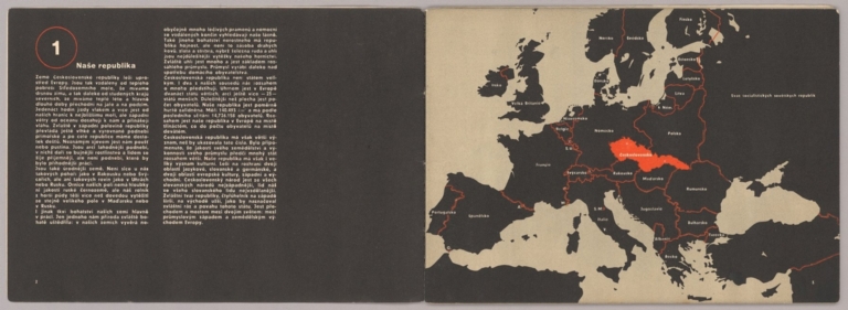
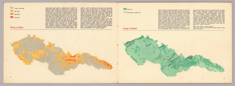
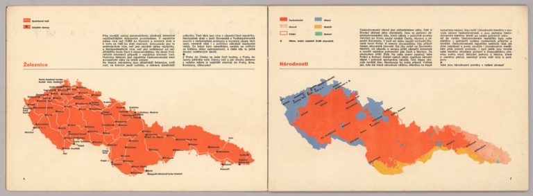
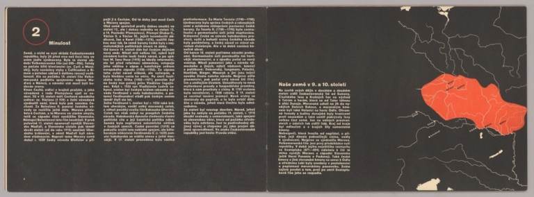

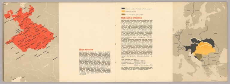
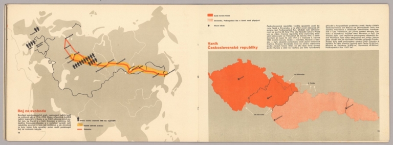
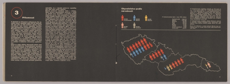
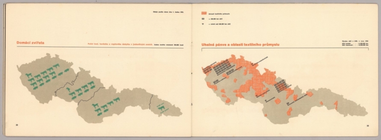
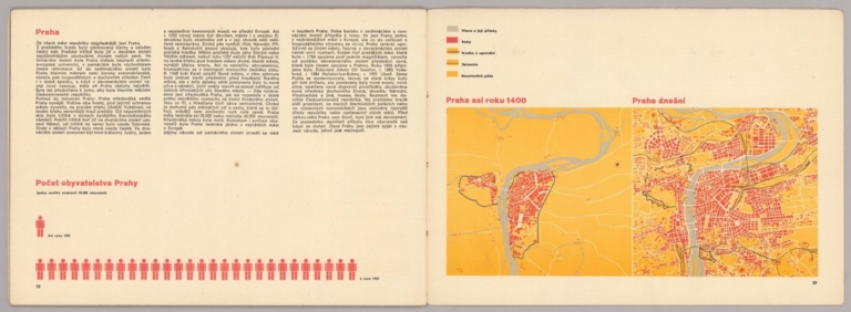


![[Übersichtskarte].](https://www.davidrumsey.com/rumsey/Size2/RUMSEY~8~1/199/14401021.jpg)