|
Author
Stanford, Edward
Full Title
(Covers to) The Instructive Atlas of Modern Geography
List No
15996.001
Note
Date estimated.
Author
Stanford, Edward
Full Title
(Title page to) The Instructive Atlas of Modern Geography
List No
15996.002
Note
Date estimated.
Author
Stanford, Edward
Full Title
The World
List No
15996.004
Note
Date estimated.
Author
Stanford, Edward
Full Title
Eastern Hemisphere
List No
15996.005
Note
Date estimated.
Author
Stanford, Edward
Full Title
Western Hemisphere
List No
15996.006
Note
Date estimated.
Author
Stanford, Edward
Full Title
England
List No
15996.008
Note
Date estimated.
Author
Stanford, Edward
Full Title
Scotland
List No
15996.009
Note
Date estimated.
Author
Stanford, Edward
Full Title
Ireland
List No
15996.010
Note
Date estimated.
Author
Stanford, Edward
Full Title
Australia
List No
15996.020
Note
Date estimated.
Author
Stanford, Edward
Full Title
New Zealand
List No
15996.021
Note
Date estimated.
Author
Logerot, A. (Auguste)
Full Title
(Covers to) Atlas elémentaire.
List No
14489.001
Note
Covers to Atlas elémentaire. Folio. Bound in board, covered in marbled papers. With leather spine.
Author
Logerot, A. (Auguste)
Full Title
(Title Page to) Atlas elémentaire fait pour Monsieur A. Logerot, elève au Pensionnat Professionnel de M. Ph. Pompeé pour servir au cours professé por M. Chatteau. 1856-1857, Ivry sur Seine, 1er et 2th anviée.
List No
14489.002
Note
Title page to Atlas elémentaire ... Handwritten in ink with pencil underlines. (Page number inferred.)
Author
Logerot, A. (Auguste)
Full Title
[Map of Europe.] Ce 8 8bre 1856 ; A. Logerot.
List No
14489.003
Note
Manuscript map representing Europe. Shows select regions, mountain ranges, drainage, coastlines, and islands. Relief shown with hachure lines and shading. Indexed to indicate the names of mountain ranges. Ink, pencil, and watercolor on paper. Indexed to indicate locations such as the Tyrolean Alps and Saint-Gotthard Massif. Map is 24 x 30 cm, on sheet 24 x 32 cm.
Author
Logerot, A. (Auguste)
Full Title
[Map of Europe.] Ce 15 8bre 1856 ; A. Logerot.
List No
14489.004
Note
Manuscript map representing Europe. Shows select regions, cities, mountain ranges, drainage, coastlines, and islands. Relief shown with shading. Features watershed areas, which are differentiated by color. Indexed to indicate the names of mountains and lakes. Ink, pencil, and watercolor on paper. Map is 24 x 30 cm, on sheet 24 x 32 cm.
Author
Logerot, A. (Auguste)
Full Title
Mer Blanche. Ce 23 8bre 1856 ; A. Logerot.
List No
14489.005
Note
Manuscript map representing the White Sea. Shows select regions, cities, mountain ranges, drainage, coastlines, and islands. Relief shown with shading. Ink, pencil, and watercolor on paper. Map is 24 x 30 cm, on sheet 24 x 32 cm.
Author
Logerot, A. (Auguste)
Full Title
Rhin Suisse. Ce 18 Fevrier 1857 ; A. Logerot.
List No
14489.015
Note
Manuscript map representing the watershed of the Rhine River in Switzerland. Shows select regions, cities, mountain ranges, drainage, and bodies of water. Relief shown with shading. Ink, pencil, and watercolor on paper. Map is 22 x 28 cm, on sheet 24 x 31 cm.
Author
Logerot, A. (Auguste)
Full Title
[France.] A. Logerot.
List No
14489.021
Note
Manuscript map representing France. Shows select regions, mountain ranges, drainage, coastlines, and islands. Relief shown with shading. Ink, pencil, and watercolor on paper. Map is 23 x 29 cm, on sheet 24 x 31 cm.
Author
Logerot, A. (Auguste)
Full Title
[Armorican Massif, France.] Ce 98 Mai 1857 ; A. Logerot.
List No
14489.025
Note
Manuscript map representing the Armorican Massif in France. Shows select regions, cities, mountain ranges, drainage, coastlines, and islands. Relief shown with shading. Ink, pencil, and watercolor on paper. Map is 21 x 29 cm, on sheet 24 x 31 cm.
Author
Logerot, A. (Auguste)
Full Title
[Loire River.] A. Logerot.
List No
14489.026
Note
Manuscript map representing the Loire River basin in France. Shows select regions, cities, mountain ranges, drainage, coastlines, and islands. Relief shown with shading. Ink, pencil, and watercolor on paper. Map is 23 x 30 cm, on sheet 23 x 30 cm.
Author
Logerot, A. (Auguste)
Full Title
[Loire River.] A. Logerot.
List No
14489.027
Note
Manuscript map representing the Loire River basin in France. Shows select regions, cities, mountain ranges, drainage, coastlines, and islands. Relief shown with shading. Ink, pencil, and watercolor on paper. Map is 23 x 29 cm, on sheet 23 x 30 cm.
Author
Logerot, A. (Auguste)
Full Title
Asie mineure. A. Logerot.
List No
14489.038
Note
Manuscript map representing Asia Minor. Shows select regions, cities, mountain ranges, drainage, coastlines, and islands. Relief shown with shading. Ink, pencil, and watercolor on paper. Map is 21 x 27 cm, on sheet 24 x 31 cm.
Author
Logerot, A. (Auguste)
Full Title
Afrique. A. Logerot ; Ce 8 Janvier 1856.
List No
14489.041
Note
Manuscript map representing Africa. Shows select regions, cities, mountain ranges, deserts, drainage, coastlines, and islands. Relief shown with shading. Ink, pencil, and watercolor on paper. Map is 22 x 28 cm, on sheet 24 x 31 cm. (Page number written as “43” for page 44 in volume.)
Author
Logerot, A. (Auguste)
Full Title
Amerique du Noro. A. Logerot.
List No
14489.042
Note
Manuscript map representing North America. Shows select regions, mountain ranges, coastlines, and islands. Ink, pencil, and watercolor on paper. Map is 30 x 23 cm, on sheet 30 x 23 cm.
Author
Logerot, A. (Auguste)
Full Title
Amérique Septentrionale. A. Logerot.
List No
14489.043
Note
Manuscript map representing North America. Shows select regions, mountain ranges, drainage, bodies of water, coastlines, and islands. Relief shown with shading. Ink, pencil, and watercolor on paper. Map is 27 x 23 cm, on sheet 31 x 23 cm.
Author
Logerot, A. (Auguste)
Full Title
[North and South America.] A. Logerot.
List No
14489.044
Note
Manuscript map representing North and South America. Shows select regions, mountain ranges, drainage, bodies of water, coastlines, and islands. Relief shown with shading. Ink, pencil, and watercolor on paper. Map is 31 x 23 cm, on sheet 31 x 23 cm.
Author
Logerot, A. (Auguste)
Full Title
[South America.] A. Logerot.
List No
14489.045
Note
Manuscript map representing South America. Shows select regions, mountain ranges, drainage, coastlines, and islands. Relief shown with shading. Ink, pencil, and watercolor on paper. Map is 22 x 28 cm, on sheet 30 x 23 cm.
Author
Logerot, A. (Auguste)
Full Title
Océanie. A. Logerot.
List No
14489.046
Note
Manuscript map representing Oceania. Shows select regions, cities, mountain ranges, drainage, coastlines, and islands. Relief shown with shading. Ink, pencil, and watercolor on paper. Map is 22 x 28 cm, on sheet 24 x 30 cm.
Author
[Sutnar, Ladislav, Tschinkel, Augustin]
Full Title
(Covers to) Mala vlastiveda [The Little Civics Reader]
List No
15867.001
Author
[Sutnar, Ladislav, Tschinkel, Augustin]
Full Title
(Title page to) Mala vlastiveda [The Little Civics Reader]
List No
15867.002
Author
[Sutnar, Ladislav, Tschinkel, Augustin]
Full Title
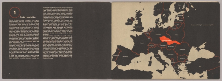
Naše republika (Our Country)
List No
15867.003
Author
[Sutnar, Ladislav, Tschinkel, Augustin]
Full Title
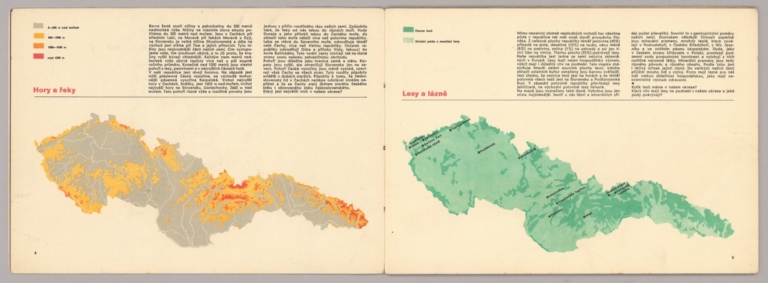
Hory a Feky (Mountains and Rivers) (with) Lesy a lázne (Forests and Land)
List No
15867.004
Author
[Sutnar, Ladislav, Tschinkel, Augustin]
Full Title
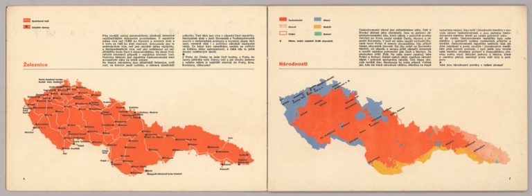
Železnice (Railways) (with) Národnosti (Nationalities)
List No
15867.005
Author
[Sutnar, Ladislav, Tschinkel, Augustin]
Full Title
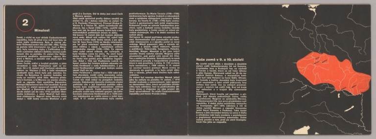
Minulest (The Past) (with) Naše země v 9. a 10. století (Our country in the 9th and 10th centuries)
List No
15867.006
Author
[Sutnar, Ladislav, Tschinkel, Augustin]
Full Title
Ríše Přemysla II. Otakara (The Empire of Přemysl II Otakara) (with) Ríše Václava lI. a Václava IIl. (The Empire of Wenceslas I. and Wenceslas III)
List No
15867.007
Author
[Sutnar, Ladislav, Tschinkel, Augustin]
Full Title
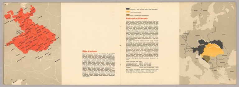
Riše Karlova (Karlova's Empire) (with) Rakousko-Uhersko (Austria Hungary)
List No
15867.008
Author
[Sutnar, Ladislav, Tschinkel, Augustin]
Full Title
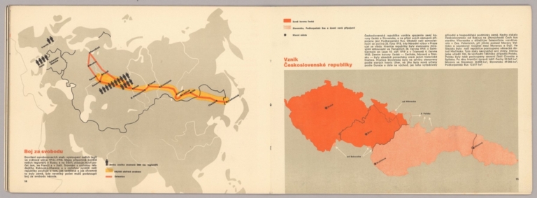
Boj za svobodu (The Fight for Freedom) (with) Vznik Československé republiky (Emergence of the Czechoslovak Republic)
List No
15867.009
Author
[Sutnar, Ladislav, Tschinkel, Augustin]
Full Title
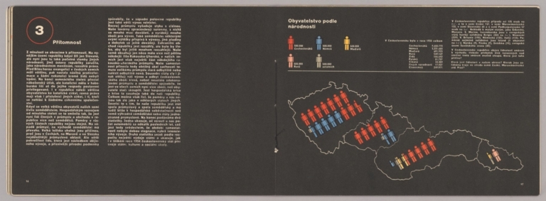
Přítomnost (Presence) (with) Obyvatelstvo podle národnosti (Population by Nationality)
List No
15867.010
Author
[Sutnar, Ladislav, Tschinkel, Augustin]
Full Title
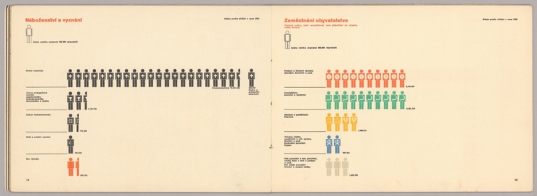
Náboženství a vyznání (Religion and Confession) (with) Zaměstnání obyvatelstva (Employment of the population)
List No
15867.011
Author
[Sutnar, Ladislav, Tschinkel, Augustin]
Full Title
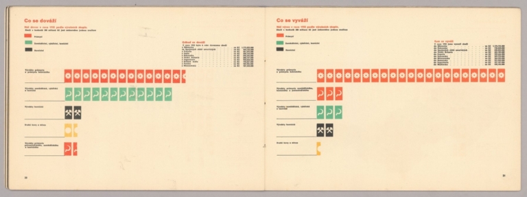
Co se dováží (What is Imported) (with) Co se vyváží (What is Exported)
List No
15867.012
Author
[Sutnar, Ladislav, Tschinkel, Augustin]
Full Title
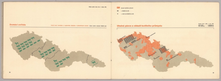
Domácí zvířata (Domestic Animals) (with) Uhelné pánve a oblasti textilního průmyslu (Coal basins and textile industry areas)
List No
15867.013
Author
[Sutnar, Ladislav, Tschinkel, Augustin]
Full Title
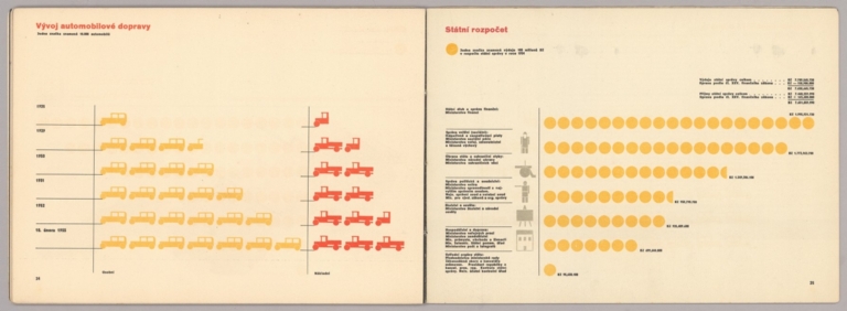
Vývoj automobilové dopravy( Development of automobile transport) (with) Státní rozpočet (State budget)
List No
15867.014
Author
[Sutnar, Ladislav, Tschinkel, Augustin]
Full Title
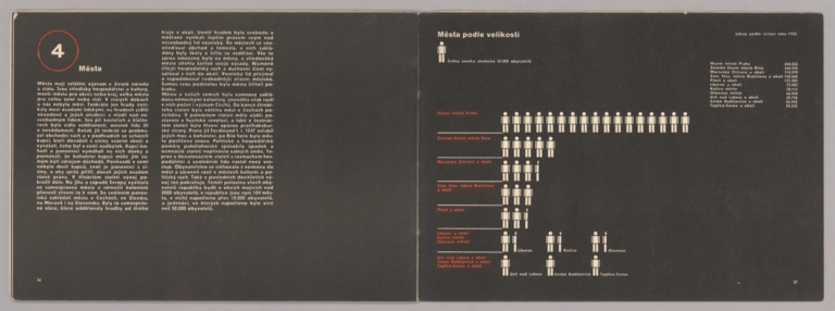
Města (Cities) (with) Města podie velikosti (Cities by Size)
List No
15867.015
Author
[Sutnar, Ladislav, Tschinkel, Augustin]
Full Title
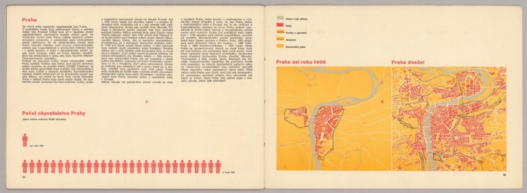
Praha (Prague) (with) Počet obyvatelstva Prahy (Population of Prague) Praha asi roku 1400 (Prague around 1400) (and) Praha dnešní (Today's Prague)
List No
15867.016
Author
[Sutnar, Ladislav, Tschinkel, Augustin]
Full Title
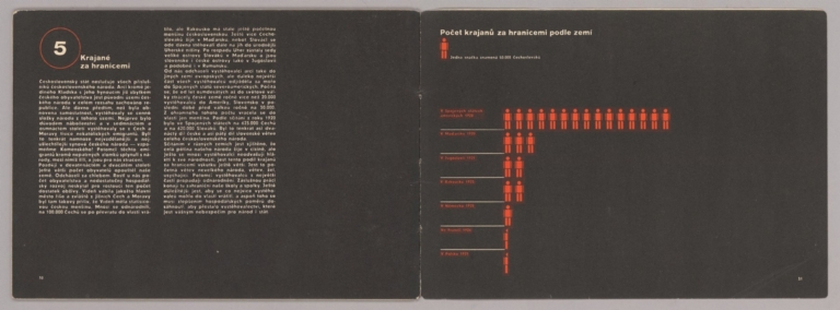
Krajané za hranicemi (Compatriots abroad) (with) Počet krajanů za hranicemi podle zemi (Number of compatriots abroad by country)
List No
15867.017
Author
[Sutnar, Ladislav, Tschinkel, Augustin]
Full Title
Malá vlastivěda Sestavil a upravil Ladislav Sutnar (The Little Civics Reader Compiled and edited by Ladislav Sutnar)
List No
15867.018
Note
Further states: The text was written and the historical part by Hidil Bedrich Mendl. Maps and diagrams were drawn by Augustin Tschinkel. The diagrams were created according to the statistical data of the State Statistical Office. The book, prepared on the basis of the prior approval of the Ministry of Education and National Education of January 16, 1931, No. 136/1931 pres., was approved by the Ministry of Education and Culture by Decree of December 31, 1932, No. 160.414/32-l/1, as a teaching aid for general and burgher schools.
Author
Finney, Ethel
Full Title
(Covers to) [Egyptian/German manuscript schoolgirl atlas].
List No
14317.001
Note
Covers to school atlas, drawn by Ethel Finney at the Deutsche Schule zu Alexandrien (German School in Alexandria) in 1900. Blue paper covers; bound with thread. Bookplate on cover with Finney's signature, date and class (II).
Author
Finney, Ethel
Full Title
Alexandrien.
List No
14317.002
Note
Manuscript map of Alexandria, Egypt. Shows streets and drainage. Drawn in graphite and colored blue pencil, with a penciled grid beneath drawing. Lettering in cursive. Map is 17 x 21 cm, on sheet 20 x 25 cm.
Author
Finney, Ethel
Full Title
Nil - Delta.
List No
14317.003
Note
Two manuscript maps of the Nile River Delta, Egypt. Maps show cities, railways, topography, lakes, drainage and coastline. Relief shown in hachures. Drawn in graphite, with a penciled grid beneath drawing. Descriptive text in lower margin. Lettering in cursive. Together, maps are 36 x 21 cm, on facing sheets, together 40 x 25 cm.
Author
Finney, Ethel
Full Title
Kairo.
List No
14317.004
Note
Two manuscript maps of Cairo, Egypt (top), and Haizer, Algeria (bottom). Maps show railways, streets, topography, lakes and drainage. Relief shown in hachures. Drawn in graphite, ink and watercolor. Descriptive text in lower margin of top map. Lettering in cursive. Together, maps are 39 x 25 cm, on facing sheets, together 40 x 25 cm.
Author
Finney, Ethel
Full Title
[Nile River Delta].
List No
14317.005
Note
Two manuscript maps of the Nile River Delta, Egypt. Maps show cities, railways, lakes, drainage and coastline. Drawn in ink and watercolor. Lettering in cursive. Together, maps are 37 x 24 cm, on facing sheets, together 40 x 25 cm.
Author
Finney, Ethel
Full Title
[Nile River, to Lake Victoria]. Alexandrien, den 22/3/1900. E. F.
List No
14317.006
Note
Manuscript map of the Nile River to Lake Victoria, Egypt. Shows cities, topography, lakes, drainage and coastlines. Relief shown in hachures. Drawn in ink and watercolor. Lettering in cursive. Map is 30 x 18 cm, on facing sheets, together 40 x 25 cm.
Author
Finney, Ethel
Full Title
Nil (bis Assouan).
List No
14317.007
Note
Manuscript map of the Nile River to Aswan, Egypt. Shows cities, seas, lakes, drainage and coastlines. Drawn in ink and watercolor. Lettering in cursive. Map is 16 x 21 cm, on sheet 20 x 25 cm.
Author
Finney, Ethel
Full Title
[Watercolor palette].
List No
14317.008
Note
Watercolor palette tested through a series of whimsical brushstrokes. On final page of atlas.
Author
Wilme, Benjamin P.
Full Title
Synopsis plate. Shewing some of the principal characters used in mapping. (to accompany) A Hand book for plain and ornamental mapping, and engineering drawing ... By Benjamin P. Wilme ... London, Published by John Weale, Martin Taylor … 1841.
List No
13138.002
Note
Uncolored plate showing summary of the characters used in mapping.
Author
Wilme, Benjamin P.
Full Title
(Title Page to) A Hand book for plain and ornamental mapping, and engineering drawing : consisting of every style of embellishment and writing used by surveyors and civil & mechanical engineers ; containing many original designs and sketches for hills, trees, cliffs, rocks, north-points, scrolls, borders, & titles for estate & parish maps, railway plans, and sections, and every description of ornament required in the above professions. By Benjamin P. Wilme, Civil –Engineer & Surveyor. London, Published by John Weale, Martin Taylor … 1841. Gardner, Zincographer, 19, Giltspur St.
List No
13138.003
Note
Handbook, with descriptive text, 2 engraved title pages and 43 plates, sketches, charts, maps, some folded and colored. Showing designs and sketches for hills, trees, cliffs, rocks, north-points, scrolls, borders, railway plans, sections and titles for estate & parish maps. With additional, engraved, title-page with title "A hand-book for mapping, engineering, and architectural drawing ... engraving, lithographing, and zincographing. By B. P. Wilme … London : Published for the author, by John Weale, 1846." Bound in brown worn marbled paper-covered boards, half leather bound with title "Wilme's Mapping" in gilt on spine.
Author
Wilme, Benjamin P.
Full Title
(Title Page to) A hand-book for mapping, engineering, and architectural drawing, in which maps of all descriptions are analyzed, and their several uses fully explained : intended for the use of civil engineers, architects, and surveyors : also for naval and military academies, engineering schools and colleges, and draughtsmen : illustrated with forty-three large plates and thirty-nine woodcuts, among which will be found examples of a parliamentary railway plan, section, and cross sections, prepared in compliance with the standing orders of the House of Commons, with plain instructions for lithographing and zincographing maps and drawings, and an exposition of the relative cost and merits of engraving, lithographing, and zincographing. By B. P. Wilme … London : Published for the author, by John Weale, 1846.
List No
13138.004
Note
Handbook, with descriptive text, 2 engraved title pages and 43 plates, sketches, charts, maps, some folded and colored. Showing designs and sketches for hills, trees, cliffs, rocks, north-points, scrolls, borders, railway plans, sections and titles for estate & parish maps. With additional, engraved, title-page with title "A hand-book for mapping, engineering, and architectural drawing ... engraving, lithographing, and zincographing. By B. P. Wilme … London : Published for the author, by John Weale, 1846." Bound in brown worn marbled paper-covered boards, half leather bound with title "Wilme's Mapping" in gilt on spine.
Author
Wilme, Benjamin P.
Full Title
(North-points). P. Wilme, delt. Gardner. Zinco : 19 Giltspur St. (to accompany) A Hand book for plain and ornamental mapping, and engineering drawing ... London, Published by John Weale, Martin Taylor … 1841. A hand-book for mapping, engineering, and architectural drawing. By B. P. Wilme … London : Published for the author, by John Weale, 1846.
List No
13138.007
Note
North point with ornamental compass rose in center.
Author
Wilme, Benjamin P.
Full Title
Scale of chains. Surveyed by B.P. Wilme 1841. P. Wilme, delt. et lith. Day & Haghe Lithrs. to the Queen. (to accompany) A Hand book for plain and ornamental mapping, and engineering drawing ... London, Published by John Weale, Martin Taylor … 1841. A hand-book for mapping, engineering, and architectural drawing. By B. P. Wilme … London : Published for the author, by John Weale, 1846.
List No
13138.008
Note
Examples of borders used in mapping.
Author
Wilme, Benjamin P.
Full Title
Woodland. Cliff. Rock. P. Wilme, delt. Gardner. Zinco : 19 Giltspur St. (to accompany) A Hand book for plain and ornamental mapping, and engineering drawing ... London, Published by John Weale, Martin Taylor … 1841. A hand-book for mapping, engineering, and architectural drawing. By B. P. Wilme … London : Published for the author, by John Weale, 1846.
List No
13138.009
Note
Examples and drawing used in mapping.
Author
Wilme, Benjamin P.
Full Title
(Text Page to) Plan of an estate. Plan of a railway in the county of Kent surveyed 1841. P. Wilme, delt. Gardner. Zinco : 19 Giltspur St. (to accompany) A Hand book for plain and ornamental mapping, and engineering drawing ... London, Published by John Weale, Martin Taylor … 1841. A hand-book for mapping, engineering, and architectural drawing. By B. P. Wilme … London : Published for the author, by John Weale, 1846.
List No
13138.010
Note
Examples of writing words, plan, section.
Author
Wilme, Benjamin P.
Full Title
(Text Page to) Plan of the parish. P. Wilme, delt. Gardner. Zinco : 19 Giltspur St. (to accompany) A Hand book for plain and ornamental mapping, and engineering drawing ... London, Published by John Weale, Martin Taylor … 1841. A hand-book for mapping, engineering, and architectural drawing. By B. P. Wilme … London : Published for the author, by John Weale, 1846.
List No
13138.011
Note
Examples of writing portions of titles.
Author
Wilme, Benjamin P.
Full Title
(Text Page to) Scale 6 chains to an inch. Standidge & Co. Litho. London. (to accompany) A Hand book for plain and ornamental mapping, and engineering drawing ... London, Published by John Weale, Martin Taylor … 1841. A hand-book for mapping, engineering, and architectural drawing. By B. P. Wilme … London : Published for the author, by John Weale, 1846.
List No
13138.012
Note
Examples of writing scales for maps.
Author
Wilme, Benjamin P.
Full Title
Method of drawing water, grafs land, sand and trees. Standidge & Co. Litho. London. (to accompany) A Hand book for plain and ornamental mapping, and engineering drawing ... London, Published by John Weale, Martin Taylor … 1841. A hand-book for mapping, engineering, and architectural drawing. By B. P. Wilme … London : Published for the author, by John Weale, 1846.
List No
13138.0123
Note
Examples of drawing water, sand, trees, limestone, etc.
Author
Wilme, Benjamin P.
Full Title
(North-points). P. Wilme, delt. Gardner. Zinco : 19 Giltspur St. (to accompany) A Hand book for plain and ornamental mapping, and engineering drawing ... London, Published by John Weale, Martin Taylor … 1841. A hand-book for mapping, engineering, and architectural drawing. By B. P. Wilme … London : Published for the author, by John Weale, 1846.
List No
13138.014
Note
Examples of compass roses showing north points.
Author
Wilme, Benjamin P.
Full Title
(Text Page to) Plan of the Parish of Shottisham in the county of Somerset. Standidge & Co. Litho. London. 1841. (to accompany) A Hand book for plain and ornamental mapping, and engineering drawing ... London, Published by John Weale, Martin Taylor … 1841. A hand-book for mapping, engineering, and architectural drawing. By B. P. Wilme … London : Published for the author, by John Weale, 1846.
List No
13138.015
Note
Examples of title for map.
Author
Wilme, Benjamin P.
Full Title
Hills No. 1. (Picturesque). From an original drawing by B. P. Wilme. (to accompany) A Hand book for plain and ornamental mapping, and engineering drawing ... London, Published by John Weale, Martin Taylor … 1841. A hand-book for mapping, engineering, and architectural drawing. By B. P. Wilme … London : Published for the author, by John Weale, 1846.
List No
13138.016
Note
Presentation of hills, mountains and summit.
Author
Wilme, Benjamin P.
Full Title
Forest trees in elevation. No. 1. Arranged & drawn to seal for maps & plans by B. P. Wilme. London. 1842. (to accompany) A Hand book for plain and ornamental mapping, and engineering drawing ... London, Published by John Weale, Martin Taylor … 1841. A hand-book for mapping, engineering, and architectural drawing. By B. P. Wilme … London : Published for the author, by John Weale, 1846.
List No
13138.017
Note
Examples of forest trees in elevation suitable for maps at a scale of 3 chains to 1 inch.
Author
Wilme, Benjamin P.
Full Title
Signs used in mapping &c. No.1. Drawn on zine by B. P. Wilme. London. 1842. (to accompany) A Hand book for plain and ornamental mapping, and engineering drawing ... London, Published by John Weale, Martin Taylor … 1841. A hand-book for mapping, engineering, and architectural drawing. By B. P. Wilme … London : Published for the author, by John Weale, 1846.
List No
13138.018
Note
Series of diagrams and signs suitable for plans drawn at a scale of 3 chains to 1 inch.
Author
Wilme, Benjamin P.
Full Title
Geological diagrams. Method of shewing strata in section as applicable to engineering drawing. B. P. Wilme delin. E. Kennion sculp. (to accompany) A Hand book for plain and ornamental mapping, and engineering drawing ... London, Published by John Weale, Martin Taylor … 1841. A hand-book for mapping, engineering, and architectural drawing. By B. P. Wilme … London : Published for the author, by John Weale, 1846.
List No
13138.019
Note
Series of geological diagrams as applicable to engineering drawing.
Author
Wilme, Benjamin P.
Full Title
(Text Page to) Alphabets, No. 1. Designed & written by B. P. Wilme. (to accompany) A Hand book for plain and ornamental mapping, and engineering drawing ... London, Published by John Weale, Martin Taylor … 1841. A hand-book for mapping, engineering, and architectural drawing. By B. P. Wilme … London : Published for the author, by John Weale, 1846.
List No
13138.020
Note
Circular examples of plain and ornamental drawing alphabets and numbers.
Author
Wilme, Benjamin P.
Full Title
(Text Page to) Illuminated initial letters. On stone by B. P. Wilme. London. 1843. (to accompany) A Hand book for plain and ornamental mapping, and engineering drawing ... London, Published by John Weale, Martin Taylor … 1841. A hand-book for mapping, engineering, and architectural drawing. By B. P. Wilme … London : Published for the author, by John Weale, 1846.
List No
13138.021
Note
Examples of ornamental drawing alphabets.
Author
Wilme, Benjamin P.
Full Title
The method of delineating mountains. Engraved by Gardner. (to accompany) A Hand book for plain and ornamental mapping, and engineering drawing ... London, Published by John Weale, Martin Taylor … 1841. A hand-book for mapping, engineering, and architectural drawing. By B. P. Wilme … London : Published for the author, by John Weale, 1846.
List No
13138.022
Note
View representing method of delineating in elevation by line engraving.
Author
Wilme, Benjamin P.
Full Title
No. 2. Strata as applicable to engineering. Stratified rocks. Designed & drawn by B.P. Wilme, London 1842. (to accompany) A Hand book for plain and ornamental mapping, and engineering drawing ... London, Published by John Weale, Martin Taylor … 1841. A hand-book for mapping, engineering, and architectural drawing. By B. P. Wilme … London : Published for the author, by John Weale, 1846.
List No
13138.023
Note
Color chart of stratified rocks.
Author
Wilme, Benjamin P.
Full Title
Application of the diagrams of strata to the projection of engineering sections. Railway section from the standing orders &c. The same section : Shewing the geological structiore of the county through which the railway passes. Outline of proposed swivel bridge. (to accompany) A Hand book for plain and ornamental mapping, and engineering drawing ... London, Published by John Weale, Martin Taylor … 1841. A hand-book for mapping, engineering, and architectural drawing. By B. P. Wilme … London : Published for the author, by John Weale, 1846.
List No
13138.024
Note
3 colored folded engineering sections.
Author
Wilme, Benjamin P.
Full Title
Method of presenting hills and vallies by normal contours or by series of lines, traced on the ground at equal vertical distances & parallel to the horizon. Desinged & drawn on zine by B.P. Wilme London 1842. (to accompany) A Hand book for plain and ornamental mapping, and engineering drawing ... London, Published by John Weale, Martin Taylor … 1841. A hand-book for mapping, engineering, and architectural drawing. By B. P. Wilme … London : Published for the author, by John Weale, 1846.
List No
13138.025
Note
Representation of hills and valleys by contours, spotheights and shadings.
Author
Wilme, Benjamin P.
Full Title
Details of rails and chairs as laid on the Midland counties railway. From actual measurement. Drawn on zine by B.P. Wilme London 1842. (to accompany) A Hand book for plain and ornamental mapping, and engineering drawing ... London, Published by John Weale, Martin Taylor … 1841. A hand-book for mapping, engineering, and architectural drawing. By B. P. Wilme … London : Published for the author, by John Weale, 1846.
List No
13138.026
Note
Color folded plans. Includes color coded index and note.
Author
Wilme, Benjamin P.
Full Title
(Text Page to) Designs for titles. (to accompany) A Hand book for plain and ornamental mapping, and engineering drawing ... London, Published by John Weale, Martin Taylor … 1841. A hand-book for mapping, engineering, and architectural drawing. By B. P. Wilme … London : Published for the author, by John Weale, 1846.
List No
13138.027
Note
Folded plate of designs for 5 titles.
Author
Wilme, Benjamin P.
Full Title
(Text Page to) Gothic letters and numbers. From Henry VIIths. Chapel Westminster. Zinco graphed by B.P. Wilme, London 1844. (to accompany) A Hand book for plain and ornamental mapping, and engineering drawing ... London, Published by John Weale, Martin Taylor … 1841. A hand-book for mapping, engineering, and architectural drawing. By B. P. Wilme … London : Published for the author, by John Weale, 1846.
List No
13138.028
Note
Examples of Gothic letters and numbers.
Author
Wilme, Benjamin P.
Full Title
Map engraving. Specimen for delineating county maps. Drawn by B.P. Wilme,C. E. Engraved by J. Gardner. (to accompany) A Hand book for plain and ornamental mapping, and engineering drawing ... London, Published by John Weale, Martin Taylor … 1841. A hand-book for mapping, engineering, and architectural drawing. By B. P. Wilme … London : Published for the author, by John Weale, 1846.
List No
13138.029
Note
Example of county map engraving in the style of Ordnance Survey. Note: "Engraved for Wilme's Hand book for mapping & engineering drawing."
Author
Wilme, Benjamin P.
Full Title
Map engraving. Method of delineating a high moorish country. Drawn by B.P. Wilme,C. E. Engraved by J. Gardner. (to accompany) A Hand book for plain and ornamental mapping, and engineering drawing ... London, Published by John Weale, Martin Taylor … 1841. A hand-book for mapping, engineering, and architectural drawing. By B. P. Wilme … London : Published for the author, by John Weale, 1846.
List No
13138.030
Note
Example of map engraving in the style of Ordnance Survey. Note: "Engraved for Wilme's Hand book for mapping & engineering drawing."
Author
Wilme, Benjamin P.
Full Title
Street improvement plan. Plan of part of the proposed street from Church Street to Vauxhall ... By B.P. Wilme,C. E. London. (to accompany) A Hand book for plain and ornamental mapping, and engineering drawing ... London, Published by John Weale, Martin Taylor … 1841. A hand-book for mapping, engineering, and architectural drawing. By B. P. Wilme … London : Published for the author, by John Weale, 1846.
List No
13138.031
Note
Color example of street drawing for engravers and lithographers. includes notes.
Author
Wilme, Benjamin P.
Full Title
Engineering drawing. Shewing the method of coloring stone & brick work. On zinc. by B.P. Wilme, London. 1843. (to accompany) A Hand book for plain and ornamental mapping, and engineering drawing ... London, Published by John Weale, Martin Taylor … 1841. A hand-book for mapping, engineering, and architectural drawing. By B. P. Wilme … London : Published for the author, by John Weale, 1846.
List No
13138.032
Note
Folded color plan, showing coloring stone and brick work in engineering drawing.
Author
Wilme, Benjamin P.
Full Title
Colours. No. 1. Shewing their admixture and use. Designed & arranged by B.P. Wilme. Engraved by Henry Martin. (to accompany) A Hand book for plain and ornamental mapping, and engineering drawing ... London, Published by John Weale, Martin Taylor … 1841. A hand-book for mapping, engineering, and architectural drawing. By B. P. Wilme … London : Published for the author, by John Weale, 1846.
List No
13138.041
Note
Chart showing "Colors uses by architects, civil and mechanical engineers, geologists & others."
Author
Wilme, Benjamin P.
Full Title
French curves. (to accompany) A Hand book for plain and ornamental mapping, and engineering drawing ... London, Published by John Weale, Martin Taylor … 1841. A hand-book for mapping, engineering, and architectural drawing. By B. P. Wilme … London : Published for the author, by John Weale, 1846.
List No
13138.042
Note
Color folded examples of French curves.
Author
[Ravenstein, August, Berlin Geographisch-Artistische Anstalt Ernst Schotte]
Full Title
(Covers to) Plastischer Schul-Atlas von August Ravenstein verlag von B. Dondorf in Frankfurt A/M. Berlin Geographisch-Artistische Anstalt Ernst Schotte.
List No
14473.001
Note
Covers to Plastischer Schul-Atlas. Box containing eight relief maps representing geography across the globe. Front cover features an illustration of figures from around the world, surrounded by a decorative border and cartouches containing title and imprint.
Author
[Ravenstein, August, Berlin Geographisch-Artistische Anstalt Ernst Schotte]
Full Title
(Title Page to) Plastischer Schul-Atlas für vie erste Stufe des Unterrichts in der Erdkunde. Enthaltend die Karten von Deutschland, Europa, Asien, Afrika, Nord- und Süd-Amerika und Australien, nebst einem Ideal-Bild der physisch-geographischen Verhältnisse. In Relief geprägt und nach der physisch-geographischen Beschaffenheit (in einer besonderen Beigabe auch nach der politischen Eintheilung) der Länder in Farben gedruckt. Vierte ganz umgearbeitet Auflage. Herausgegeben von Aug. Ravenstein. Frankfurt am Main, 1864. Stich, Vrägung, Druckt und Verlageben B. Dondorf.
List No
14473.002
Note
Title page to Plastischer Schul-Atlas. Includes imprint and legend pertaining to maps. Appears on verso to front cover of box that houses atlas.
Author
[Ravenstein, August, Berlin Geographisch-Artistische Anstalt Ernst Schotte]
Full Title
Karten-Ideal zur elementaren Darstellung der topischen Verhältnisse von Wasser und Land auf dem Erdboden, nebst der Oestl. & Westl. Erdhälfte, zur Erläuterung mathemat. eintheilung u. physisch-geograph. Verhältnisse. Zeichnung u. Modell von August Ravenstein in Frankfurt a. M. Stich, Prägung, Druck u. Verlag von B. Dondorf in Frankfurt a. M.
List No
14473.003
Note
Relief map of the world, shown as the Western and Eastern Hemispheres, as well as a closer view of the Netherlands and vicinity. Shows geographical regions, topography, vegetation, bodies of water, drainage, coastlines, shoals and islands. Topography shown with raised relief. Includes latitudinal and longitudinal lines, as well as descriptive notes. Legend for map appears on title page. Colored lithograph. Map is 22 x 27 cm, within frame 24 x 28 cm. Within a series of eight maps comprising the school atlas, Plastischer Schul-Atlas.
Author
[Ravenstein, August, Berlin Geographisch-Artistische Anstalt Ernst Schotte]
Full Title
Deutschland nebst den Königreichen Holland, Belgien und der Republik Schweiz. Zeichnung u. Modell von August Ravenstein in Frankfurt a. M. Stich, Prägung, Druck u. Verlag von B. Dondorf in Frankfurt a. M.
List No
14473.004
Note
Relief map of Germany, the Netherlands, Belgium and Switzerland. Shows geographical regions, countries, cities, railways, canals, topography, vegetation, bodies of water, drainage, coastlines, shoals and islands. Topography shown with raised relief. Includes a legend, bar scale given in miles, latitudinal and longitudinal lines, as well as statistical and descriptive notes. Additional legend for map appears on title page. Colored lithograph. Map is 22 x 27 cm, within frame 24 x 28 cm. Within a series of eight maps comprising the school atlas, Plastischer Schul-Atlas.
Author
[Ravenstein, August, Berlin Geographisch-Artistische Anstalt Ernst Schotte]
Full Title
Europa. Zeichnung u. Modell von August Ravenstein in Frankfurt a. M. Stich, Prägung, Druck u. Verlag von B. Dondorf in Frankfurt a. M.
List No
14473.005
Note
Relief map of Europe. Shows geographical regions, countries, cities, railways, topography, vegetation, bodies of water, drainage, coastlines, shoals and islands. Topography shown with raised relief. Includes a legend, bar scale given in miles, latitudinal and longitudinal lines, as well as statistical and descriptive notes. Additional legend for map appears on title page. With a vignette of scenery, figures, fauna and flora. Colored lithograph. Map is 22 x 27 cm, within frame 24 x 28 cm. Within a series of eight maps comprising the school atlas, Plastischer Schul-Atlas.
Author
[Ravenstein, August, Berlin Geographisch-Artistische Anstalt Ernst Schotte]
Full Title
Asien. Zeichnung u. Modell von August Ravenstein in Frankfurt a. M. Stich, Prägung, Druck u. Verlag von B. Dondorf in Frankfurt a. M.
List No
14473.006
Note
Relief map of Asia. Shows geographical regions, countries, cities, railways, topography, vegetation, bodies of water, drainage, coastlines, shoals and islands. Topography shown with raised relief. Includes a legend, bar scale given in miles, latitudinal and longitudinal lines, as well as statistical and descriptive notes. Additional legend for map appears on title page. With an indexed vignette of scenery, indigenous figures, fauna and flora. Colored lithograph. Map is 22 x 27 cm, within frame 24 x 28 cm. Within a series of eight maps comprising the school atlas, Plastischer Schul-Atlas.
Author
[Ravenstein, August, Berlin Geographisch-Artistische Anstalt Ernst Schotte]
Full Title
Nord-u. Mittel-Amerika. Zeichnung u. Modell von August Ravenstein in Frankfurt a. M. Stich, Prägung, Druck u. Verlag von B. Dondorf in Frankfurt a. M.
List No
14473.007
Note
Relief map of North and Central America. Shows geographical regions, countries, cities, railways, topography, vegetation, bodies of water, drainage, coastlines, shoals and islands. Topography shown with raised relief. Includes a legend, bar scale given in miles, latitudinal and longitudinal lines, as well as statistical and descriptive notes. Additional legend for map appears on title page. With an indexed vignette of scenery, figures, fauna and flora. Colored lithograph. Map is 27 x 22 cm, within frame 28 x 24 cm. Within a series of eight maps comprising the school atlas, Plastischer Schul-Atlas.
Author
[Ravenstein, August, Berlin Geographisch-Artistische Anstalt Ernst Schotte]
Full Title
Südamerika. Zeichnung u. Modell von August Ravenstein in Frankfurt a. M. Stich, Prägung, Druck u. Verlag von B. Dondorf in Frankfurt a. M.
List No
14473.008
Note
Relief map of South America. Shows geographical regions, countries, cities, railways, topography, vegetation, bodies of water, drainage, coastlines, shoals and islands. Topography shown with raised relief. Includes a legend, bar scale given in miles, latitudinal and longitudinal lines, as well as statistical and descriptive notes. Additional legend for map appears on title page. With an indexed vignette of scenery, figures, fauna and flora. Colored lithograph. Map is 27 x 22 cm, within frame 28 x 24 cm. Within a series of eight maps comprising the school atlas, Plastischer Schul-Atlas.
Author
[Ravenstein, August, Berlin Geographisch-Artistische Anstalt Ernst Schotte]
Full Title
Afrika. Zeichnung u. Modell von August Ravenstein in Frankfurt a. M. Stich, Prägung, Druck u. Verlag von B. Dondorf in Frankfurt a. M.
List No
14473.009
Note
Relief map of Africa. Shows geographical regions, countries, cities, railways, topography, vegetation, bodies of water, drainage, coastlines, shoals and islands. Topography shown with raised relief. Includes a legend, bar scale given in miles, latitudinal and longitudinal lines, as well as statistical and descriptive notes. Additional legend for map appears on title page. With an indexed vignette of scenery, figures, fauna and flora. Colored lithograph. Map is 22 x 27 cm, within frame 24 x 28 cm. Within a series of eight maps comprising the school atlas, Plastischer Schul-Atlas.
Author
[Ravenstein, August, Berlin Geographisch-Artistische Anstalt Ernst Schotte]
Full Title
Australien und Polynesien. Zeichnung u. Modell von August Ravenstein in Frankfurt a. M. Stich, Prägung, Druck u. Verlag von B. Dondorf in Frankfurt a. M.
List No
14473.010
Note
Relief map of Australia and Polynesia. Shows geographical regions, countries, cities, railways, topography, vegetation, bodies of water, drainage, coastlines, shoals and islands. Topography shown with raised relief. Includes a legend, bar scale given in miles, latitudinal and longitudinal lines, as well as statistical and descriptive notes. Additional legend for map appears on title page. With an indexed vignette of scenery, figures, fauna and flora. Colored lithograph. Map is 22 x 27 cm, within frame 24 x 28 cm. Within a series of eight maps comprising the school atlas, Plastischer Schul-Atlas.
Author
Gallardo y Rionda, J.P.
Full Title
(Covers to) Cartilla Geografica del Distrito Federal (Geographical booklet of the federal district, arranged expressly for schools, by the engineer J.P. Gallardo y Rionda... corrected and enlarged. Sixth edition. 1888)
List No
15466.001
Author
Gallardo y Rionda, J.P.
Full Title
(Title page to) Cartilla Geografica del Distrito Federal (Geographical booklet of the federal district, arranged expressly for schools, by the engineer J.P. Gallardo y Rionda... corrected and enlarged. Sixth edition. 1888)
List No
15466.002
Author
Gallardo y Rionda, J.P.
Full Title
(Text page to) Cartilla Geografica del Distrito Federal (Geographical booklet of the federal district, arranged expressly for schools, by the engineer J.P. Gallardo y Rionda... corrected and enlarged. Sixth edition. 1888)
List No
15466.003
Author
Gallardo y Rionda, J.P.
Full Title
(Text page to) Cartilla Geografica del Distrito Federal (Geographical booklet of the federal district, arranged expressly for schools, by the engineer J.P. Gallardo y Rionda... corrected and enlarged. Sixth edition. 1888)
List No
15466.004
Author
Gallardo y Rionda, J.P.
Full Title
(Text page to) Cartilla Geografica del Distrito Federal (Geographical booklet of the federal district, arranged expressly for schools, by the engineer J.P. Gallardo y Rionda... corrected and enlarged. Sixth edition. 1888)
List No
15466.005
Author
Gallardo y Rionda, J.P.
Full Title
(Text page to) Cartilla Geografica del Distrito Federal (Geographical booklet of the federal district, arranged expressly for schools, by the engineer J.P. Gallardo y Rionda... corrected and enlarged. Sixth edition. 1888)
List No
15466.006
|


![[Europe.]](https://www.davidrumsey.com/rumsey/Size2/RUMSEY~8~1/213/14489003.jpg)
![[Europe.]](https://www.davidrumsey.com/rumsey/Size2/RUMSEY~8~1/213/14489004.jpg)


![[France.]](https://www.davidrumsey.com/rumsey/Size2/RUMSEY~8~1/213/14489021.jpg)
![[Armorican Massif, France.]](https://www.davidrumsey.com/rumsey/Size2/RUMSEY~8~1/213/14489025.jpg)
![[Loire River.]](https://www.davidrumsey.com/rumsey/Size2/RUMSEY~8~1/213/14489026.jpg)
![[Loire River.]](https://www.davidrumsey.com/rumsey/Size2/RUMSEY~8~1/213/14489027.jpg)


![[North and South America.]](https://www.davidrumsey.com/rumsey/Size2/RUMSEY~8~1/213/14489044.jpg)
![[South America.]](https://www.davidrumsey.com/rumsey/Size2/RUMSEY~8~1/213/14489045.jpg)

![Covers: Mala vlastiveda [The Little Civics Reader]](https://media.davidrumsey.com/MediaManager/srvr?mediafile=/Size3/RUMSEY~8~1/213/15867001.jpg)
![Title: Mala vlastiveda [The Little Civics Reader]](https://media.davidrumsey.com/MediaManager/srvr?mediafile=/Size3/RUMSEY~8~1/213/15867002.jpg)

![Covers: [Egyptian/German manuscript schoolgirl atlas].](https://www.davidrumsey.com/rumsey/Size2/RUMSEY~8~1/205/14317001.jpg)


![[Nile River Delta].](https://www.davidrumsey.com/rumsey/Size2/RUMSEY~8~1/205/14317005.jpg)
![[Nile River, to Lake Victoria].](https://www.davidrumsey.com/rumsey/Size2/RUMSEY~8~1/205/14317006.jpg)

![[Watercolor palette].](https://www.davidrumsey.com/rumsey/Size1/RUMSEY~8~1/205/14317008.jpg)


