|
Author
Anonymous
Full Title
青康藏公路 (Qingkang-Tibet Highway.)
List No
15841.000
Author
Vsesoi︠u︡znyĭ nauchno-izdatelʹskiĭ institut izobrazitelʹnoĭ statistiki (Soviet Union)
Full Title
MOCKOBCKИE MAГИCTPAЛИ XVII BEKA.
List No
14399.023
Note
Map representing Moscow, Russia, featuring the roads of the 17th century. Shows city limits, roads, bodies of water and drainage. Colored lithograph. Map is 32 x 32 cm, on sheet 34 x 34 cm. With descriptive text on facing page, printed in black.
Author
Vsesoi︠u︡znyĭ nauchno-izdatelʹskiĭ institut izobrazitelʹnoĭ statistiki (Soviet Union)
Full Title
MOCKOBCKИE MAГИCTPAЛИ XVIII BEKA.
List No
14399.024
Note
Map representing Moscow, Russia, featuring the roads of the 18th century. Shows city limits, roads, bodies of water and drainage. Colored lithograph. Map is 32 x 32 cm, on sheet 34 x 34 cm. With descriptive text on facing page, printed in black.
Author
Vsesoi︠u︡znyĭ nauchno-izdatelʹskiĭ institut izobrazitelʹnoĭ statistiki (Soviet Union)
Full Title
УЗЛЫ KOCЫX ПEPEУЛKOB.
List No
14399.026
Note
Map representing Moscow, Russia, featuring alleyways. Shows city limits, roads, bodies of water and drainage. Colored lithograph. Map is 17 x 19 cm, on sheet 34 x 34 cm. With descriptive text, printed in black.
Author
Vsesoi︠u︡znyĭ nauchno-izdatelʹskiĭ institut izobrazitelʹnoĭ statistiki (Soviet Union)
Full Title
Teopeмцуecкaя плaнцpoвкa юpoдoв.
List No
14399.027
Note
Eight maps representing Moscow, Russia, as well as Paris, London and Berlin, featuring the actual city plans, as well as theoretical plans. Maps show city limits, roads, bodies of water and drainage, as well as the outskirts of the cities. Colored lithograph. Together, maps are 16 x 31 cm, on sheet 34 x 34 cm. With descriptive text on facing page, printed in black.
Author
Fry, Herbert, 1830-1885
Full Title
(Covers to) London in 1885. Illustrated by 18 Bird's-Eye Views Of The Principal Streets.
List No
15859.001
Author
Fry, Herbert, 1830-1885
Full Title
(Title page to) London in 1885. Illustrated by 18 Bird's-Eye Views Of The Principal Streets.
List No
15859.002
Author
Fry, Herbert, 1830-1885
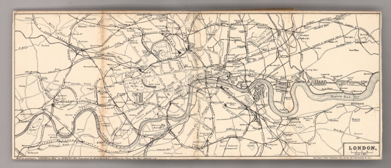
Full Title
London
List No
15859.005
Author
Fry, Herbert, 1830-1885
Full Title
Plate I. From Charing Cross Through Whitehall To Westminster.
List No
15859.006
Author
Fry, Herbert, 1830-1885
Full Title
Plate II. The Strand. From Charing Cross to Fleet Street.
List No
15859.007
Author
Fry, Herbert, 1830-1885
Full Title
Plate III. Fleet Street and Ludgate Hill, To St. Paul's and Cheapside, Etc.
List No
15859.008
Author
Fry, Herbert, 1830-1885
Full Title
Plate IV, Cannon Street, To The Mansion House, The Tower, Etc.
List No
15859.009
Author
Fry, Herbert, 1830-1885
Full Title
Plate V. From Charing Cross Through Pall Mall To Pimlico.
List No
15859.010
Author
Fry, Herbert, 1830-1885
Full Title
Plate VI. Regent Street, From Waterloo Place to Portland Place.
List No
15859.011
Author
Fry, Herbert, 1830-1885
Full Title
Plate VII. St. James Street, And Old and New Bond Streets.
List No
15859.012
Author
Fry, Herbert, 1830-1885
Full Title
Plate VIII. Piccadilly. From The Haymarket To Hyde Park Corner.
List No
15859.013
Author
Fry, Herbert, 1830-1885
Full Title
Plate IX. Edgware Road, From Marble Arch To Westbourne Grove.
List No
15859.014
Author
Fry, Herbert, 1830-1885
Full Title
Plate X. Oxford Street, From The Marble Arch To Tottenham Court Road.
List No
15859.015
Author
Fry, Herbert, 1830-1885
Full Title
Plate XI. Baker Street, From Oxford Street To Regent's Park And St. John's Wood.
List No
15859.016
Author
Fry, Herbert, 1830-1885
Full Title
Plate XII. Tottenham Court Road And Hempstead Road, To Camden Town.
List No
15859.017
Author
Fry, Herbert, 1830-1885
Full Title
Plate XIII. New Oxford Street And Holborn, To Smithfield And Cheapside.
List No
15859.018
Author
Fry, Herbert, 1830-1885
Full Title
Plate XIV. Euston Road And Marylebone Road, King's Cross to Paddington.
List No
15859.019
Author
Fry, Herbert, 1830-1885
Full Title
Plate XV. From The Poultry To Bishopsgate Street And To Whitechapel.
List No
15859.020
Author
Fry, Herbert, 1830-1885
Full Title
Plate XVI. The City Road, Finsbury Circus To The "Angel" Islington.
List No
15859.021
Author
Fry, Herbert, 1830-1885
Full Title
Plate XVII. From London Bridge Through The Borough, To Newington Butts And St. George's Fields.
List No
15859.022
Author
Fry, Herbert, 1830-1885
Full Title
Plate XVIII. The Thames, From The Tower to Westminster.
List No
15859.023
Author
Fry, Herbert, 1830-1885
Full Title
(Composite views) Plates VIII, IX, XIV, XVIII. London in 1885. Illustrated by 18 Bird's-Eye Views Of The Principal Streets.
List No
15859.024
Note
Compsoite of views overlaid on the 1886 Library Map of London and Its Suburbs (our 10158.000).
Author
Fry, Herbert, 1830-1885
Full Title
(Composite views) Plates V, X, XIII, XV, XVII. London in 1885. Illustrated by 18 Bird's-Eye Views Of The Principal Streets.
List No
15859.025
Note
Compsoite of views overlaid on the 1886 Library Map of London and Its Suburbs (our 10158.000).
Author
Fry, Herbert, 1830-1885
Full Title
(Composite views) Plates II, III, IV, VI, XI. London in 1885. Illustrated by 18 Bird's-Eye Views Of The Principal Streets.
List No
15859.026
Note
Compsoite of views overlaid on the 1886 Library Map of London and Its Suburbs (our 10158.000).
Author
Fry, Herbert, 1830-1885
Full Title
(Composite views) Plates I, VII, XII, XVI.. London in 1885. Illustrated by 18 Bird's-Eye Views Of The Principal Streets.
List No
15859.027
Note
Compsoite of views overlaid on the 1886 Library Map of London and Its Suburbs (our 10158.000).
Author
Fry, Herbert, 1830-1885
Full Title
(Composite views) Plates I - XVIII. London in 1885. Illustrated by 18 Bird's-Eye Views Of The Principal Streets.
List No
15859.028
Note
Compsoite of views overlaid on the 1886 Library Map of London and Its Suburbs (our 10158.000).
Author
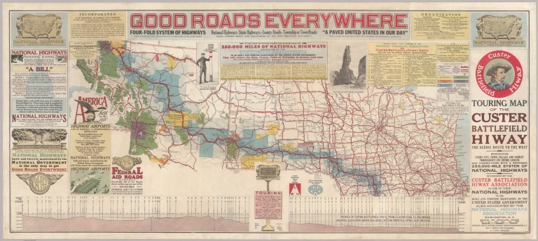
[Mulford, John C., National Highways Association, Faunce, C.C.]
Full Title
Touring Map of the Custer Battlefield Hiway The Scenic Route to the West.
List No
15808.000
Author
[Thomas, George Coupland, Thomas Bros.]
Full Title
Highways of the Western States. (to accompany) Thomas Bros. map of the city & county of San Francisco. Copyright by Geo. C. Thomas. Compiled and published by Tohmas Bros... Oakland 12, Calif. (Cover title) Thomas Bros. San Francisco info-guide and complete detailed colorful street map. Copyright 1945 by George Coupland Thomas.
List No
11147.008
Note
Color map, 54 x 67, folded in green heavy paper cover 19 x 11, with title "San Francisco info-guide and complete detailed colorful street map". With 60 pages of street index, text and index to points of interest, uncolored views, and 5 maps. Map showing city boundaries, address block numbers, schools, parks, street car routes, cable car and bus lines and points of interest. Relief shown by hachures.
Author
Gazette Printing Company Limited
Full Title
1 [Explorez avec la Champlain + 70].
List No
14404.002
Note
Map of part of Lake Ontario and its northern vicinity, Canada. Shows cities, roads, topography, vegetation, bodies of water, drainage and shoreline. Topography shown pictorially. Features pictorial representations of the cultural character within the area, such as indigenous figures, farmers and animals. Includes a compass rose, with north oriented toward top right of map. With an inset vignette of scenery. Decorative border. Colored lithograph. Map is 24 x 17 cm, on sheet 26 x 20 cm. "Démarrez en vitesse avec la Champlain + 70" [= Get off to a fast start with the Champlain].
Author
Gazette Printing Company Limited
Full Title
2 [Explorez avec la Champlain + 70].
List No
14404.003
Note
Map of part of Lake Ontario and its northern vicinity, Canada. Shows cities, roads, topography, vegetation, bodies of water, drainage and shoreline. Topography shown pictorially. Features pictorial representations of the cultural character within the area, such as indigenous figures, farmers and animals. Includes a compass rose, with north oriented toward top right of map. With an inset vignette of scenery. Decorative border. Colored lithograph. Map is 24 x 17 cm, on sheet 26 x 20 cm. "Explore with Champlain + 70."
Author
Gazette Printing Company Limited
Full Title
3 [Explorez avec la Champlain + 70].
List No
14404.004
Note
Map of part of Southern Ontario, Canada. Shows cities, roads, topography, vegetation, bodies of water and drainage. Topography shown pictorially. Features pictorial representations of the cultural character within the area, such as farmers and animals. Includes a compass rose, with north oriented toward top right of map. With an inset vignette of scenery. Decorative border. Colored lithograph. Map is 24 x 17 cm, on sheet 26 x 20 cm. "La Champlain + 70 assure puissance - souplesse - rapidité!" [= The Champlain + 70 ensures power - flexibility - speed!].
Author
Gazette Printing Company Limited
Full Title
4 [Explorez avec la Champlain + 70].
List No
14404.005
Note
Map of part of Southern Ontario, Canada. Shows cities, roads, topography, vegetation, bodies of water and drainage. Topography shown pictorially. Features pictorial representations of the cultural character within the area, such as farmers and animals. Includes a compass rose, with north oriented toward top right of map. With an inset vignette of scenery. Decorative border. Colored lithograph. Map is 24 x 17 cm, on sheet 26 x 20 cm. "It's always "bon voyage" with Champlain + 70."
Author
Gazette Printing Company Limited
Full Title
5 [Explorez avec la Champlain + 70].
List No
14404.006
Note
Map of Montreal and its vicinity in Quebec, Canada. Shows cities, roads, topography, vegetation, bodies of water and drainage. Topography shown pictorially. Features pictorial representations of the cultural character within the area, such as farmers and animals. Includes a compass rose, with north oriented toward top right of map. With an inset vignette of scenery. Decorative border. Colored lithograph. Map is 24 x 17 cm, on sheet 26 x 20 cm. "La Champlain + 70 assure un plus fort milage" [= The Champlain + 70 ensures a higher milage].
Author
Gazette Printing Company Limited
Full Title
6 [Explorez avec la Champlain + 70].
List No
14404.007
Note
Map of part Southern Quebec, Canada. Shows cities, roads, topography, vegetation, bodies of water and drainage. Topography shown pictorially. Features pictorial representations of the cultural character within the area, such as farmers and animals. Includes a compass rose, with north oriented toward top right of map. With an inset vignette of scenery. Decorative border. Colored lithograph. Map is 24 x 17 cm, on sheet 26 x 20 cm. "Champlain + 70 is "climatized" for all weathers."
Author
Gazette Printing Company Limited
Full Title
7 [Explorez avec la Champlain + 70].
List No
14404.008
Note
Map of part of Southern Quebec, Canada. Shows cities, roads, topography, vegetation, bodies of water and drainage. Topography shown pictorially. Features pictorial representations of the cultural character within the area, such as hunters, fishermen and animals. Includes a compass rose, with north oriented toward top right of map. With an inset vignette of scenery. Decorative border. Colored lithograph. Map is 24 x 17 cm, on sheet 26 x 20 cm. "Demarrez en vitesse avec le benzol Champlain" [= Get off to a speedy start with benzol Champlain].
Author
Gazette Printing Company Limited
Full Title
8 [Explorez avec la Champlain + 70].
List No
14404.009
Note
Map of Lake Nipissing and its vicinity in Ontario, Canada. Shows cities, roads, topography, vegetation, bodies of water and drainage. Topography shown pictorially. Features pictorial representations of the cultural character within the area, such as indigenous figures, fishermen and animals. Includes a compass rose, with north oriented toward top right of map. With an inset vignette of scenery. Decorative border. Colored lithograph. Map is 24 x 17 cm, on sheet 26 x 20 cm. "Explore with Champlain benzol."
Author
Gazette Printing Company Limited
Full Title
9 [Explorez avec la Champlain + 70].
List No
14404.010
Note
Map of Algonquin National [Provincial] Park and its vicinity in Ontario, Canada. Shows cities, roads, topography, vegetation, bodies of water and drainage. Topography shown pictorially. Features pictorial representations of the cultural character within the area, such as indigenous figures, fishermen and animals. Includes a compass rose, with north oriented toward top right of map. With an inset vignette of scenery. Decorative border. Colored lithograph. Map is 24 x 17 cm, on sheet 26 x 20 cm. "C'est toujours "bon voyage" avec la Champlain" [= It's always "bon voyage" with the Champlain].
Author
Gazette Printing Company Limited
Full Title
10 [Explorez avec la Champlain + 70].
List No
14404.011
Note
Map of Algonquin National [Provincial] Park and its vicinity in Ontario, Canada. Shows cities, roads, topography, vegetation, bodies of water and drainage. Topography shown pictorially. Features pictorial representations of the cultural character within the area, such as farmers, hunters and animals. Includes a compass rose, with north oriented toward top right of map. With an inset vignette of scenery. Decorative border. Colored lithograph. Map is 24 x 17 cm, on sheet 26 x 20 cm. "Get off to a flying start with Champlain + 70."
Author
Gazette Printing Company Limited
Full Title
11 [Explorez avec la Champlain + 70].
List No
14404.012
Note
Map of part of Ontario, Canada. Shows cities, roads, topography, vegetation, bodies of water and drainage. Topography shown pictorially. Features pictorial representations of the cultural character within the area, such as farmers, hunters and animals. Includes a compass rose, with north oriented toward top right of map. With an inset vignette of scenery. Decorative border. Colored lithograph. Map is 24 x 17 cm, on sheet 26 x 20 cm. "La Champlain + 70 est "climatisée" pour toutes températures" [= The Champlain + 70 is "air-conditioned" for all temperatures].
Author
Gazette Printing Company Limited
Full Title
12 [Explorez avec la Champlain + 70].
List No
14404.013
Note
Map of part of Ontario, Canada. Shows cities, roads, topography, vegetation, bodies of water and drainage. Topography shown pictorially. Features pictorial representations of the cultural character within the area, such as fishermen, hunters and animals. Includes a compass rose, with north oriented toward top right of map. With an inset vignette of scenery. Decorative border. Colored lithograph. Map is 24 x 17 cm, on sheet 26 x 20 cm. "Champlain + 70 ensures power - pep - speed!"
Author
Gazette Printing Company Limited
Full Title
13 [Explorez avec la Champlain + 70].
List No
14404.014
Note
Map of part of Quebec, Canada. Shows cities, roads, topography, vegetation, bodies of water and drainage. Topography shown pictorially. Features pictorial representations of the cultural character within the area, such as farmers, hunters and animals. Includes a compass rose, with north oriented toward top right of map. With an inset vignette of scenery. Decorative border. Colored lithograph. Map is 24 x 17 cm, on sheet 26 x 20 cm. "Voyagez avec le benzol Champlain" [= Travel with benzol Champlain].
Author
Gazette Printing Company Limited
Full Title
14 [Explorez avec la Champlain + 70].
List No
14404.015
Note
Map of part of Quebec, Canada. Shows cities, roads, topography, vegetation, bodies of water and drainage. Topography shown pictorially. Features pictorial representations of the cultural character within the area, such as farmers, fishermen and animals. Includes a compass rose, with north oriented toward top right of map. With an inset vignette of scenery. Decorative border. Colored lithograph. Map is 24 x 17 cm, on sheet 26 x 20 cm. "Champlain + 70 means more and smoother miles."
Author
Gazette Printing Company Limited
Full Title
15 [Explorez avec la Champlain + 70].
List No
14404.016
Note
Map of part of the Saint Lawrence River in Quebec, Canada. Shows cities, roads, topography, vegetation, bodies of water and drainage. Topography shown pictorially. Features pictorial representations of the cultural character within the area, such as farmers, hunters and animals. Includes a compass rose, with north oriented toward top right of map. With an inset vignette of scenery. Decorative border. Colored lithograph. Map is 24 x 17 cm, on sheet 26 x 20 cm. "Voyagez en sureté avec la Champlain + 70" [= Travel safely with the Champlain + 70].
Author
Gazette Printing Company Limited
Full Title
16 [Explorez avec la Champlain + 70].
List No
14404.017
Note
Map of part of the Saint Lawrence River in Quebec, Canada. Shows cities, roads, topography, vegetation, bodies of water and drainage. Topography shown pictorially. Features pictorial representations of the cultural character within the area, such as farmers, hunters and animals. Includes a compass rose, with north oriented toward top right of map. With an inset vignette of scenery. Decorative border. Colored lithograph. Map is 24 x 17 cm, on sheet 26 x 20 cm. "Champlain benzol will get you there."
Author
Gazette Printing Company Limited
Full Title
17 [Explorez avec la Champlain + 70].
List No
14404.018
Note
Map of part of the Saint Lawrence River in Quebec, Canada. Shows cities, roads, topography, vegetation, bodies of water and drainage. Topography shown pictorially. Features pictorial representations of the cultural character within the area, such as fishermen, hunters and animals. Includes a compass rose, with north oriented toward top right of map. With an inset vignette of scenery. Decorative border. Colored lithograph. Map is 24 x 17 cm, on sheet 26 x 20 cm. "La Champlain + 70 vous mènera ici et la" [= The Champlain + 70 will take you here and there].
|


![1 [Explorez avec la Champlain + 70].](https://www.davidrumsey.com/rumsey/Size1/RUMSEY~8~1/205/14404002.jpg)
![2 [Explorez avec la Champlain + 70].](https://www.davidrumsey.com/rumsey/Size2/RUMSEY~8~1/205/14404003.jpg)
![3 [Explorez avec la Champlain + 70].](https://www.davidrumsey.com/rumsey/Size1/RUMSEY~8~1/205/14404004.jpg)
![4 [Explorez avec la Champlain + 70].](https://www.davidrumsey.com/rumsey/Size1/RUMSEY~8~1/205/14404005.jpg)
![5 [Explorez avec la Champlain + 70].](https://www.davidrumsey.com/rumsey/Size1/RUMSEY~8~1/205/14404006.jpg)
![6 [Explorez avec la Champlain + 70].](https://www.davidrumsey.com/rumsey/Size1/RUMSEY~8~1/205/14404007.jpg)
![7 [Explorez avec la Champlain + 70].](https://www.davidrumsey.com/rumsey/Size1/RUMSEY~8~1/205/14404008.jpg)
![8 [Explorez avec la Champlain + 70].](https://www.davidrumsey.com/rumsey/Size1/RUMSEY~8~1/205/14404009.jpg)
![9 [Explorez avec la Champlain + 70].](https://www.davidrumsey.com/rumsey/Size2/RUMSEY~8~1/205/14404010.jpg)
![10 [Explorez avec la Champlain + 70].](https://www.davidrumsey.com/rumsey/Size2/RUMSEY~8~1/205/14404011.jpg)
![11 [Explorez avec la Champlain + 70].](https://www.davidrumsey.com/rumsey/Size1/RUMSEY~8~1/205/14404012.jpg)
![12 [Explorez avec la Champlain + 70].](https://www.davidrumsey.com/rumsey/Size1/RUMSEY~8~1/205/14404013.jpg)
![13 [Explorez avec la Champlain + 70].](https://www.davidrumsey.com/rumsey/Size1/RUMSEY~8~1/205/14404014.jpg)
![14 [Explorez avec la Champlain + 70].](https://www.davidrumsey.com/rumsey/Size2/RUMSEY~8~1/205/14404015.jpg)
![15 [Explorez avec la Champlain + 70].](https://www.davidrumsey.com/rumsey/Size2/RUMSEY~8~1/205/14404016.jpg)
![16 [Explorez avec la Champlain + 70].](https://www.davidrumsey.com/rumsey/Size1/RUMSEY~8~1/205/14404017.jpg)
![17 [Explorez avec la Champlain + 70].](https://www.davidrumsey.com/rumsey/Size2/RUMSEY~8~1/205/14404018.jpg)