|
REFINE
Browse All : Rivers from 1866
1-4 of 4
Author
Coloney, Fairchild & Co.
Full Title
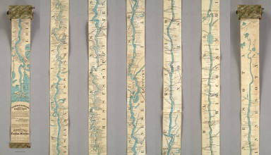
Coloney & Fairchild's Patent Ribbon Maps ... Ribbon Map Of The Father Of Waters. Geographical and Scenic Maps upon this plan of all the rivers, rail road routes, stage and coast lines in the country are in preparation.
List No
4995.000
Note
This is the most ambitious Coloney & Fairchild strip or ribbon map: it shows the Mississippi River from its delta to its source at Lake Itaska, a distance of 2600 miles. It is backed on linen and rolls into paper covered spool with a hand crank. This is the revised edition, with much additional material added on river towns by William Bowen, President of the Pilot's Association of St. Louis (this information comes from the promotion for this map printed on the Ribbon Map of New York City). No record of the first issue found, although a copy exists at the Minnesota Historical Society. The river is colored blue against a black and white background. Distances from New Orleans are printed on the river at intervals to the source. Karrow's listing is for a variant: the map printed in five strips on one sheet and folded into the 1866 edition of Edward's Gazetteer of the Mississippi River. Scarce.
Author
Coloney, Fairchild & Co.
Full Title
Coloney & Fairchild's Patent Ribbon Maps ... Ribbon Map Of The Father Of Waters. Geographical and Scenic Maps upon this plan of all the rivers, rail road routes, stage and coast lines in the country are in preparation.
List No
4995.001
Note
This is the most ambitious Coloney & Fairchild strip or ribbon map: it shows the Mississippi River from its delta to its source at Lake Itaska, a distance of 2600 miles. It is backed on linen and rolls into paper covered spool with a hand crank. This is the revised edition, with much additional material added on river towns by William Bowen, President of the Pilot's Association of St. Louis (this information comes from the promotion for this map printed on the Ribbon Map of New York City). No record of the first issue found, although a copy exists at the Minnesota Historical Society. The river is colored blue against a black and white background. Distances from New Orleans are printed on the river at intervals to the source. Karrow's listing is for a variant: the map printed in five strips on one sheet and folded into the 1866 edition of Edward's Gazetteer of the Mississippi River. Scarce.
Author
Colton, G.W.
Full Title
(Text Page) Principal Rivers and Lakes in the world.
List No
4825.007
Author
Colton, G.W.
Full Title
Mountains & Rivers. Published by G.W. & C.B. Colton, No. 172 William St., New York.
List No
4825.008
Note
Comparative chart showing river lengths and receiving water bodies. Another portion shows relative mountain heights as grouped by continent.
1-4 of 4
|