|
Author
Zero Per Zero
Full Title
Amsterdam railway system. July 2013. Railway city map : Amsterdam. Designed + Produced by Zero Per Zero.
List No
13005.003
Note
2 maps on 1 sheet 52x38, both sides folded into slip cover with slots inside for passport ticket and pass card. Amsterdam Railway System takes a motif from tulip, the Dutch symbol. With the Central Station at the center, lines of tram, metro, and railway spreads out like the stamen and pistil of the flower. The IJssel (Het IJ, river) forms the petals, and layers of fan-shaped canals. Maps showing landmarks, tourist attractions, train stations, airports, street, parks, cemetery and service terminals. Landmarks shown pictorially. Includes lists of Metro and Tram stations and key to symbols.
Author
[Zauer, Ivan Fedorovich, Ilyin, A.]
Full Title
Skhema zheleznykh dorog Rossiiskoi Imperii. Izdanie I. F. Zauera 1910 ... Kartograficheskoe Zavedenie A. Il'ina.
List No
13340.000
Author
Automobile Club of China
Full Title
Automobile Club of China. Official road map of Shanghai and district. 1936 edition. Specially drawn for A.C.C. by S. E. Faber, 1936.
List No
13356.000
Author
Harris
Full Title
Map of Washington Territory and Oregon : with portions of the adjoining territories with the route of the Seattle & Walla-Walla Rail Road.
List No
13367.000
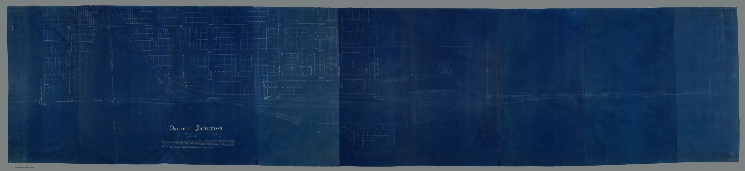
Author
Chicago, Burlington, and Quincy Railroad
Full Title
Pacific Junction. Scale 50 ft = 1 inch. Jan 1885. Received at Lincoln Oct 19, 1892
List No
10295.000
Note
Blueprint. See our vellum copy, 10288.000 Note that this blueprint has the later date Oct 19, 1892
Author
[Atchison and Nebraska Railroad, Chicago, Burlington, and Quincy Railroad]
Full Title
Composite: 24 sheets. A. & N. R.R. (Plans for route of Atchison and Nebraska Railroad)
List No
10287.025
Note
A set of 24 hand-drawn and colored maps showing the route of the proposed Atchison and Nebraska Railroad in northern Kansas and southern Nebraska, just west of the Missouri River. Many annotations in pencil list the land owners of parcels the proposed railroad line goes through and the cost per acre under sale contract. There are also notes on sheet 8 on the Condemnation of land for an owner who will not sell. The line appears to have been built approximately according to the drawings although in some areas the route was changed - this is based on comparing the routes shown on the 1887 county maps. The set of maps provides a detailed record of how land was secured for the railroads and how the lines were surveyed. View in Google Earth https://rumsey3.s3.amazonaws.com/Atchison_and_Nebraska_Railroad_1872.kmz
Author
[Atchison and Nebraska Railroad, Chicago, Burlington, and Quincy Railroad]
Full Title
Composite: County maps of Richardson county in Nebraska, and Doniphan, Brown, and Atchison counties in Kansas.
List No
10287.026
Note
A set of 24 hand-drawn and colored maps showing the route of the proposed Atchison and Nebraska Railroad in northern Kansas and southern Nebraska, just west of the Missouri River. Many annotations in pencil list the land owners of parcels the proposed railroad line goes through and the cost per acre under sale contract. There are also notes on sheet 8 on the Condemnation of land for an owner who will not sell. The line appears to have been built approximately according to the drawings although in some areas the route was changed - this is based on comparing the routes shown on the 1887 county maps. The set of maps provides a detailed record of how land was secured for the railroads and how the lines were surveyed. View in Google Earth https://rumsey3.s3.amazonaws.com/Atchison_and_Nebraska_Railroad_1872.kmz
Author
[Atchison and Nebraska Railroad, Chicago, Burlington, and Quincy Railroad]
Full Title
Composite: 24 sheets. A. & N. R.R. (Plans for route of Atchison and Nebraska Railroad)
List No
10287.027
Note
A set of 24 hand-drawn and colored maps showing the route of the proposed Atchison and Nebraska Railroad in northern Kansas and southern Nebraska, just west of the Missouri River. Many annotations in pencil list the land owners of parcels the proposed railroad line goes through and the cost per acre under sale contract. There are also notes on sheet 8 on the Condemnation of land for an owner who will not sell. The line appears to have been built approximately according to the drawings although in some areas the route was changed - this is based on comparing the routes shown on the 1887 county maps. The set of maps provides a detailed record of how land was secured for the railroads and how the lines were surveyed. View in Google Earth https://rumsey3.s3.amazonaws.com/Atchison_and_Nebraska_Railroad_1872.kmz
Author
[Atchison and Nebraska Railroad, Chicago, Burlington, and Quincy Railroad]
Full Title
1. A. & N. R.R. (Plans for route of Atchison and Nebraska Railroad)
List No
10287.001
Note
A set of 24 hand-drawn and colored maps showing the route of the proposed Atchison and Nebraska Railroad in northern Kansas and southern Nebraska, just west of the Missouri River. Many annotations in pencil list the land owners of parcels the proposed railroad line goes through and the cost per acre under sale contract. There are also notes on sheet 8 on the Condemnation of land for an owner who will not sell. The line appears to have been built approximately according to the drawings although in some areas the route was changed - this is based on comparing the routes shown on the 1887 county maps. The set of maps provides a detailed record of how land was secured for the railroads and how the lines were surveyed. View in Google Earth https://rumsey3.s3.amazonaws.com/Atchison_and_Nebraska_Railroad_1872.kmz
Author
[Atchison and Nebraska Railroad, Chicago, Burlington, and Quincy Railroad]
Full Title
2. A. & N. R.R. (Plans for route of Atchison and Nebraska Railroad)
List No
10287.002
Note
A set of 24 hand-drawn and colored maps showing the route of the proposed Atchison and Nebraska Railroad in northern Kansas and southern Nebraska, just west of the Missouri River. Many annotations in pencil list the land owners of parcels the proposed railroad line goes through and the cost per acre under sale contract. There are also notes on sheet 8 on the Condemnation of land for an owner who will not sell. The line appears to have been built approximately according to the drawings although in some areas the route was changed - this is based on comparing the routes shown on the 1887 county maps. The set of maps provides a detailed record of how land was secured for the railroads and how the lines were surveyed. View in Google Earth https://rumsey3.s3.amazonaws.com/Atchison_and_Nebraska_Railroad_1872.kmz
Author
[Atchison and Nebraska Railroad, Chicago, Burlington, and Quincy Railroad]
Full Title
3. A. & N. R.R. (Plans for route of Atchison and Nebraska Railroad)
List No
10287.003
Note
A set of 24 hand-drawn and colored maps showing the route of the proposed Atchison and Nebraska Railroad in northern Kansas and southern Nebraska, just west of the Missouri River. Many annotations in pencil list the land owners of parcels the proposed railroad line goes through and the cost per acre under sale contract. There are also notes on sheet 8 on the Condemnation of land for an owner who will not sell. The line appears to have been built approximately according to the drawings although in some areas the route was changed - this is based on comparing the routes shown on the 1887 county maps. The set of maps provides a detailed record of how land was secured for the railroads and how the lines were surveyed. View in Google Earth https://rumsey3.s3.amazonaws.com/Atchison_and_Nebraska_Railroad_1872.kmz
Author
Generalstabens litografiska anstalt.
Full Title
Karta Till Sveriges Statsbanors Anslagstidtabell. Generalstabens Litografiska Anstalt Stockholm 1947. (inset) Skane.
List No
13268.000
Note
Map To the Swedish State Railways and tourist train map, illustrating at the top the season of the midnight sun, (May 31 to August 14), with the northernmost rail line reaching Kopparasen and a narrow gauge line reaching Narvik. Map shows various routes and stations. Includes legend and time table.
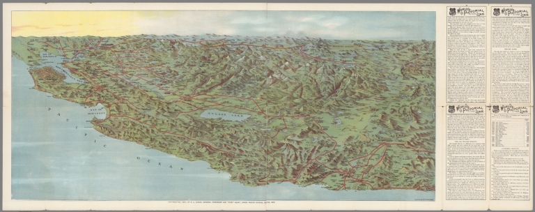
Author
Union Pacific Railway Company.
Full Title
World's pictorial line : birdseye view of the great Salt Lake Basin reached via the Union Pacific, the overland route. Knight, Leonard & Co., Printers and engravers, Chicago, Ill. Copyrighted. 1893, by E.L. Lomax, General passenger and ticket agent, Union Pacific System, Omaha, Neb.
List No
13206.003
Note
Color pictorial map, on sheet 114 x 45, folded to 23 x 10. Title from cover, with 28 pages of text. On verso 24 pages of text "Sights and scenes in Idaho and Montana", on recto text pages 25-28. Includes logo of "Union Pacific, the overland route" on cover. Map shows major cities, routes, rivers and mountains. Relief shown pictorially.
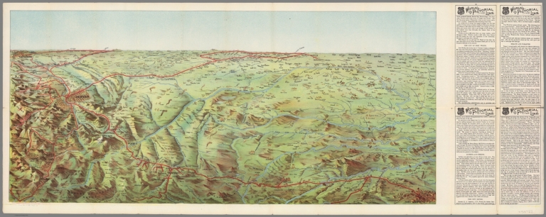
Author
Union Pacific Railway Company
Full Title
World's pictorial line : birdseye view of the Pacific Slope reached via the Union Pacific, the overland route. Copyrighted. 1893, by E.L. Lomax, General passenger and ticket agent, Union Pacific System, Omaha, Neb. Knight, Leonard & Co., Printers and engravers, Chicago, Ill.
List No
13207.003
Note
Color pictorial map, on sheet 45x114, folded to 23 x 10. Title from cover, with 28 pages of text. On verso 24 pages of text "Sights and scenes in California", on recto text pages 25-28. Includes logo of "Union Pacific, the overland route" on cover. Map shows major cities, routes, rivers and mountains. Relief shown pictorially.
Author
Stummer, Joseph
Full Title
(Composite map) Bildliche Darstellung der Geschichte der ausschl. privil. Kaiser Ferdinand`s Nordbahn vom Beginn des Betriebes bis zum abgelaufenen Jahre. Entworfen end bearbeitet von Josef. Stummer, Lithographie und farbendrund von H. Engle. Wien 1855.
List No
13248.010
Note
Composite of of 9 lithographs, including 8 sheets and title page.
Author
Union Pacific Railroad Company
Full Title
World's pictorial line. Birdseye view of the Texas Pan Handle reached via the Union Pacific. The Overland Route ... Knight, Leonard & Co., Printers, Chicago.
List No
13198.003
Note
The text is titled "Sights and scenes in the Texas Pan Handle." On the verso is a large full color birdseye view Texas to Colorado, showing the route of the Union Pacific in bright red. The view extends from Fort worth to Cheyenne and Denver on the west. Folded into self wrappers.
Author
[Bertillon, Jacques, 1851-1922, Seine. Service de la statistique municipale]
Full Title
Paris 1888 : Recette kilometriques des tramways et chemin de fer de ceinture de Paris. A. Baudry del. Grave chez L. Wuhrer. Imp. Lemercier et Cie. (to accompany) Atlas de statistique graphique de la ville de Paris. I-II. Annee 1888. Paris : G. Masson,1889.
List No
13101.019
Note
Map of Paris on 2 sheets. Showing the average line length of the tramway and railway systems of Paris. Includes notes and legend.
Author
Bowers, David
Full Title
Locomotive map of the United States : A collection of representative types and classes. Dedicated to the romance and history of American Railroading. Designed and drawn by David Bowers. Published and copyright 1935 by J.L. Smith Co. Philadelphia, U.S.A.
List No
11607.000
Note
Color map of the United States, surrounded by illustration of various types of locomotives, with name of steam and electric trains, representing the history and progress of American railroad. Shows state boundaries. Includes railroad equipment, compass rose and notes. "The named trains on the map shows the modern movements in steam and electric transportation in the United States."
Author
[Zauer, Ivan Fyodorovich, Ilyin, A.]
Full Title
Skhema zhelieznykh dorog : Evropeiskoi Rossii. Izdanie I.F. Zauera 1914 goda ... Kartograficheskoe zavedenie A. Il'ina, S. Peterburg.
List No
13026.000
Note
Map of railway system of the European part of the Russian Empire on sheet 98x133.5. backed with linen, dissected into 16 sections folded to 24.5x33. the publication of I.F. Zauera. Printed in St. Petersburg, A. Ilyin cartographic institution. Showing railway tracks, roads, cities, passenger and commodity stations and lines under construction. Includes alphabetical list of railways there are more than 40 items and distances between settlements. Map includes numerous insets showing the plans of railway junctions and terminals in the cities. Ivan Fyodorovich Sauer was the compiler of various railway directories, in particular, "Compilations of freight distance distances", as well as diagrams of railways.
Author
Zero per Zero
Full Title
Beijing : Beijing railway system/ March 2016. Designed + produced by Zero Per Zero. Printed in Korea.
List No
11868.000
Note
Updated large color map Beijing railway system, draws its motive from Chinese character for the word "China". The railways are place around the center of 6 ring roads, which are Beijing's distinctive feature. Map is in Chinese and English, showing urban and suburban lines, stations, service terminals, parks and tourist attractions. Includes legend. For copies of this map see http://www.zeroperzero.com/
Author
Zero per Zero
Full Title
European railway system/ April 2014. Designed + produced by Zero Per Zero. Printed in Korea. (inset) Scandinavia.
List No
11869.000
Note
Updated large color circular map Europe railway network of 30 European countries, with railway system of Scandinavia. Designed in the image of the earth seen from the space by Zero per Zero. Map showing political divisions, capitals, major cities, ports, landmarks, high speed lines, main lines and other lines. Includes legend and list of European countries at the lower margin. Relief shown pictorially. For copies of this map see http://www.zeroperzero.com/
Author
Zero per Zero
Full Title
New York City Railway system/ February 2011. Designed + produce by Zero Per Zero. Printed in Korea.
List No
11870.000
Note
Updated large color Railway system map of New York City in orange. Designed and produced by Zero Per Zero, printed with black background, inspired by the shape of heart from Milton Glaser's "I love NY" logo. Famous landmarks and tourist attractions are incorporated into the map, creating a sense of New York City as a tourist spot. Zero Per Zero City Railway System is a new approach to projecting the identity of a city onto its subway map. Showing streets, parks, cemetery, tourist attractions, train stations, airports, express and normal trains. Landmarks shown pictorially. Includes legend and street index. For copies of this map see http://www.zeroperzero.com/
Author
Zero per Zero
Full Title
Seoul Railway system/ December 2016. (on verso) Seoul. Designed + produced by Zero Per Zero. Printed in Korea.
List No
11873.001
Note
2 updated large color maps of Seoul on 1 sheet both sides. Includes: Railway system map of Seoul metropolitan area and untitled map of Seoul. Designed and produced by Zero Per Zero. Famous landmarks and tourist attractions are incorporated into the map as the area updated. Both maps showing subways, light and other railways, tourist attractions, public buildings, train stations, parks, rivers, mountains and airports. Landmarks shown pictorially. Includes legend, lists of stations and symbols. Relief shown pictorially. Note: "Station names and opening dates of the unbuilt subway lines are subject to change." For copies of this map see http://www.zeroperzero.com/
Author
Zero per Zero
Full Title
Tokyo : Tokyo Railway system/ June 2015. Designed + produced by Zero Per Zero. Printed in Korea.
List No
11874.000
Note
Large updated color map of Tokyo in English and Japanese. Designed and produced by Zero Per Zero, printed with black background. Famous landmarks and tourist attractions are incorporated into the map as the area updated. Showing the railway lines spread out to span the entire city along concentric circles, JR lines, subways, private railways,Tokyo Bay, tourist attractions, train stations and rivers. Landmarks shown pictorially. Includes legend. For copies of this map see http://www.zeroperzero.com/
Author
Zero per Zero
Full Title
London Railway system. April 2014. Designed + produced by Zero Per Zero. Printed in Korea.
List No
11875.000
Note
Large color map of London railway network. Designed and produced by Zero Per Zero, with decorative border with notations to shopping and tourist attraction. Famous landmarks and tourist attractions are incorporated into the map as the area updated. Showing the zone system, railway lines spread out to span the entire city, underground and other railways, tourist attractions, train stations, airports and riverboat stations. Landmarks shown pictorially. Includes legend and key to symbols. For copies of this map see http://www.zeroperzero.com/
Author
Zero per Zero
Full Title
Paris Railway system. July 2012. Designed + produced by Zero Per Zero. Printed in Korea.
List No
11876.000
Note
Large color map of Paris railway network. Designed and produced by Zero Per Zero. The inspiration for the design of Paris Railway System came from the Eiffel Tower, the Seine sketches the arch and silhouette of the Eiffel Tower, which the combination of Metro, RER and Tram, filling in the body of the Eiffel Tower. The beams of searchlights zooming out from the very top of the Eiffel Tower and the clouds representing the zone system. Famous landmarks and tourist attractions are incorporated into the map. Showing the tourist attractions, train stations, airports and service terminals. Landmarks shown pictorially. Includes lists of Metro, RER and Tramway stations and key to symbols. For copies of this map see http://www.zeroperzero.com/
Author
[A. Ilyin Cartographic Establishment, Ilyin, A.]
Full Title
Plan goroda Moskvy. Izdani Kartograficheskoe zavedenie A. Il'ina.
List No
11935.000
Note
Colored detail plan of Moscow and suburbs on sheet 99 x81, dissected into 30 sections back with linen, folded to 20x14. Date estimated. Shows wards and rural field boundaries, landmarks, buildings, roads, railroads, horse-car lines, city blocks, rivers, parks, forests, rivers, lakes and bridges.
Author
[Hauchecorne, G., Vandermaelen, Philippe, 1795-1869, Etablissement geographique de Bruxelles]
Full Title
(Composite map) Carte generale des chemins de fer de l' Europe dressee d' apres des documents officiels, par G. Hauchecorne, Agent General de Chemins de fer. 1863. Etablissement geographique de Bruxelles, fonde par Ph. Vander Maelen. (Cover title) Schweizerische Nordostbahn.
List No
11612.011
Note
Composite railroad map of Europe, sheets 1-9. First edition railroad map of Europe. 1 map in 9 double page sheets. Full color by country. One of several large-scale railway maps produced by G. Hauchecorne, Agent General de Chemins de Fer, for the great Brussels publisher Philippe Vandermaelen. Each map includes separate title, showing railway system of each country, roads, major cities, towns, stations and distances between the larger cities. Railway routes shown in solid and broken lines. All lines represent the route and distances. Relief shown by hachures. Atlas title is from the first plate. The first map (Great Britain) includes inset of map of London and fourth plate (France, Espagne) includes inset map of Paris. Bound in black paper cover boards with label "Schweizerische Nordostbahn" pasted on front cover.
Author
Minard, Charles Joseph, 1781-1870
Full Title
Carte figurative et approximative du mouvement des combustibles minéraux sur les voies d'eau et de fer de l'Empire français pendant l'année 1859 [Movements of mineral fuels on railways and waterways in the year 1859].
List No
10136.002
Note
Folds into covers with label "Tonnages des Combustibles 1859." Robinson, no.24. Inscribed by Minard to Charles Didion. Charles Didion (1803-1882) was a French engineer and presumably made Minard's acquaintance at the School for Bridges and Roads, where Didion later became secretary of the general council.
Author
Minard, Charles Joseph, 1781-1870
Full Title
Carte figurative et approximative du mouvement des combustibles minéraux sur les voies d'eau et de fer de l'Empire français pendant l'année 1860 [Movements of mineral fuels on railways and waterways in the year 1860].
List No
10137.002
Note
Folds into covers with label "Combustibles Mineraux 1860." Robinson, no.29. Signed by Minard.
Author
Minard, Charles Joseph, 1781-1870
Full Title
Carte figurative et approximative des tonnages de marchandises qui ont circulé sur les chemins de fer et les voies navigables (en flottables) de France en 1850 [Flow of merchandise in France on railways and waterways in the year 1850].
List No
10138.002
Note
Folds into covers with label "Tonnages 1850" Robinson, no.7. Signed by Minard. This map is part of a 9 map subset of the 15 Minard maps that shows the flow of merchandise in France on railways and waterways in the years 1850 to 1861, Pub List No.'s 10138.000 to 10146.000
Author
Minard, Charles Joseph, 1781-1870
Full Title
Carte figurative et approximative des tonnages de marchandises qui ont circulé sur les chemins de fer et les voies d'eau en France en 1853. [Flow of merchandise in France on railways and waterways in the year 1853].
List No
10139.002
Note
Folds into covers with label "Tonnages 1853" Robinson, no.10. Signed by Minard. This map is part of a 9 map subset of the 15 Minard maps that shows the flow of merchandise in France on railways and waterways in the years 1850 to 1861, Pub List No.'s 10138.000 to 10146.000
Author
Minard, Charles Joseph, 1781-1870
Full Title
Carte figurative et approximative des tonnages de marchandises qui ont circulé en 1855 sur les voies d'eau et fer de l'Empire français. [Flow of merchandise in France on railways and waterways in the year 1855].
List No
10140.002
Note
Folds into covers with label "Tonnages 1855" Robinson, no.12. This map is part of a 9 map subset of the 15 Minard maps that shows the flow of merchandise in France on railways and waterways in the years 1850 to 1861, Pub List No.'s 10138.000 to 10146.000
Author
Minard, Charles Joseph, 1781-1870
Full Title
Carte figurative et approximative des tonnages de marchandises qui ont circulé en 1856 sur les voies d'eau et fer de l'Empire français. [Flow of merchandise in France on railways and waterways in the year 1856].
List No
10141.002
Note
Folds into covers with label "Tonnages 1856" Robinson, no.13. Inscribed by Minard to Charles Didion. Charles Didion (1803-1882) was a French engineer and presumably made Minard's acquaintance at the School for Bridges and Roads, where Didion later became secretary of the general council. This map is part of a 9 map subset of the 15 Minard maps that shows the flow of merchandise in France on railways and waterways in the years 1850 to 1861, Pub List No.'s 10138.000 to 10146.000
Author
Minard, Charles Joseph, 1781-1870
Full Title
Carte figurative et approximativedes tonnages de marchandises qui ont circulé en 1857 sur les voies d'eau et fer de l'Empire français. [Flow of merchandise in France on railways and waterways in the year 1857].
List No
10142.002
Note
Folds into covers with label "Tonnages 1857" Robinson, no.17. Inscribed by Minard to Charles Didion. Charles Didion (1803-1882) was a French engineer and presumably made Minard's acquaintance at the School for Bridges and Roads, where Didion later became secretary of the general council. This map is part of a 9 map subset of the 15 Minard maps that shows the flow of merchandise in France on railways and waterways in the years 1850 to 1861, Pub List No.'s 10138.000 to 10146.000
Author
Minard, Charles Joseph, 1781-1870
Full Title
Carte figurative et approximative des tonnages de marchandises qui ont circulé en 1858 sur les voies d'eau et fer de l'Empire français. [Flow of merchandise in France on railways and waterways in the year 1858].
List No
10143.002
Note
Folds into covers with label "Tonnages 1858, Tonnages des Voies et Fer" Robinson, no.21. Signed by Minard. This map is part of a 9 map subset of the 15 Minard maps that shows the flow of merchandise in France on railways and waterways in the years 1850 to 1861, Pub List No.'s 10138.000 to 10146.000
Author
Minard, Charles Joseph, 1781-1870
Full Title
Carte figurative et approximative des tonnages de marchandises qui ont circulé en 1859 sur les voies d'eau et fer de l'Empire français. [Flow of merchandise in France on railways and waterways in the year 1859].
List No
10144.002
Note
Folds into covers with label "Tonnages des Marchandises 1859" Robinson, no.25. Inscribed by Minard to Charles Didion. Charles Didion (1803-1882) was a French engineer and presumably made Minard's acquaintance at the School for Bridges and Roads, where Didion later became secretary of the general council. This map is part of a 9 map subset of the 15 Minard maps that shows the flow of merchandise in France on railways and waterways in the years 1850 to 1861, Pub List No.'s 10138.000 to 10146.000
Author
Minard, Charles Joseph, 1781-1870
Full Title
Carte figurative et approximative des tonnages de marchandises qui ont circulé en 1860 sur les voies d'eau et fer de l'Empire français. [Flow of merchandise in France on railways and waterways in the year 1860].
List No
10145.002
Note
Folds into covers with label "Tonnages 1860" Robinson, no.28. Signed by Minard. This map is part of a 9 map subset of the 15 Minard maps that shows the flow of merchandise in France on railways and waterways in the years 1850 to 1861, Pub List No.'s 10138.000 to 10146.000
Author
Minard, Charles Joseph, 1781-1870
Full Title
Carte figurative et approximative des tonnages de marchandises qui ont circulé en 1861 sur les voies d'eau et fer de l'Empire français. [Flow of merchandise in France on railways and waterways in the year 1861].
List No
10146.002
Note
Folds into covers with label "Tonnages 1861" Robinson, no.32. Signed by Minard. Dated 1861 above the top neatline. This map is part of a 9 map subset of the 15 Minard maps that shows the flow of merchandise in France on railways and waterways in the years 1850 to 1861, Pub List No.'s 10138.000 to 10146.000
Author
[Schweizerische Bundesbahnen, Art. Institut Orell Fussli, Gauchat,P.]
Full Title
Map Showing the International Railway Connections of Switzerland. (cover title) Switzerland and her International Railway Connections. Switzerland The Very Heart of Europe. Printed in Switzerland by Art. Institut Orell Fussli, Zurich. Published by The Swiss Federal Railroads. 1933.
List No
11596.002
Note
Pictorial map on sheet 46x50, originally published in 1931, showing the international railway connections of Switzerland, folding to pamphlet 23x10, with pictorial cover, illustration of Swiss scenery and portrait of William at upper right corner by P. Gauchat from the earlier edition on recto, On verso text: "The Land of Contrasts", information on Railway Tickets and explanation on the railway map. Map surrounded by humorous characters, sailing ships, and a blimp, shows Switzerland at the center of a network of railways from southern England at the upper left to Venice and Florence at the lower right, also showing major cities and towns. Relief shown by hachures.
Author
Santa Fe (Railway).
Full Title
Growth of the Santa Fe (Railway).
List No
12340.000
Author
[Uren, Charles Edward, Bradley & Co.]
Full Title
Map of Bradley & Co's ditch property near Alta Station after the slide. E.C. Uren.
List No
11715.000
Note
Hand colored manuscript map of two heavy slides of earth that obstructed the tracks of the Central Pacific Railway near Alta California. From historical records it appears that the map may detail two slides that occurred along the railroad. The largest slide occurred in the Spring of 1866 during construction of the railroad and is shown in the center of the map with damages and repairs to the various ditches that ran through the area. The April 21, 1866 edition of the Dutch Flat Enquirer mentions "LAND SLIDE.—A huge land slide occurred a few days since near Buckley's ranch, just above this place, on the line of the C. P. Railroad, damaging the ditches of the Dutch Flat Water Company to the amount of several thousand dollars, and rendering a change of the railroad bed necessary, which will also cost an immense sum. Nearly a quarter section, extending along a heavy fill of the railroad several hundred yards, suddenly gave way and moved off in a solid body, taking with it ditches, flumes and everything else that obstructed its course, and making a change from the original survey of the railroad at that point imperative. The material that gave way, it seems, was of a soapy or pipe clay formation, and the pressure from the railroad fill is assigned as the cause." We estimate the map was drawn by Uren in 1880, looking back at that 1866 slide and also showing the recent 1880 slide that blocked the tracks in the upper left part of the map. The 1880 slide was recorded in the Scientific American issue Volume 42, noting that hydraulic mining techniques were used to blast away the debris covering the tracks. The map is unusual in showing illustrations of two Chinese Camps near the railroad line. With decorative compass rose, oriented with the north to upper left margin. Map showing railroad, steam engine, two views of Chinese camps, slide areas and views of Flume and water ditches. Date estimated. Uren writes his name on the map as E.C. Uren while we believe he is Charles Edward Uren.
Author
Lloyd, James T.
Full Title
Lloyd's New Map of the United States, the Canadas and New Brunswick, From the latest Surveys showing every Railroad & Station Finished to June 1864, and the Atlantic and Gulf Coasts.
List No
12387.001
Note
Color. Has a pasted-in sheet which provides a legend relating to map colors and areas of Unioin and Confederate control in the American Civil War as of October 4, 1864. Also includes a note warning customers of a substandard series of maps being sold under the brand "Lloyd's Maps".
Author
[Routledge, Fred A., 1873-1936, Prentiss]
Full Title
Airplane Map of the State of Oregon. (inset) The Columbia River Highway and the Mt. Hood Loop.
List No
12450.002
Note
Date estimated.
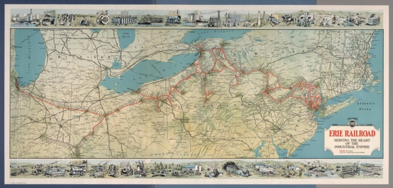
Author
[Whitney-Graham Company, Inc., Erie Railroad Company]
Full Title
Ship and travel by fast Erie Service. Erie Railroad serving the heart of industrial empire. (to accompany) The blue book of map making : America's map makers. R.W.C. The Whitney-Graham Co. Inc. (5 insets).
List No
11489.022
Note
Color map folded. Includes illustration of industry and agriculture on upper and lower panels. Map showing Erie Railroad and trackage rights over railroad in color. Also shows state boundaries, cities, towns and roads.
Author
[Vignelli Associates, Vignelli, Massimo (1931-2014)]
Full Title
New York City Subway Diagram, 2012.
List No
12364.000
Note
Schematic of the New York City subway system. A later edition of the iconic 1972 map (see our 9891.000).
Author
Soviet Union. Glavnoe upravlenie geodezii i kartografii
Full Title
(Composite map of) Skhema zheleznykh dorog Soiuza SSR. Glavnoe Upravlenie Geodezii i Kartografii pri Sovete Ministrov SSSR. Moskva, 1991. Karta sostavlena i podgotovlena k pechati fabrikoĭ no. 4 GUGK v 1980 g.Ispravlena v 1990. GUGK SSSR 1981g-1991 g. (9 insets).
List No
11260.005
Note
Composite image of sheets 1-4 of railway map of Russia.
Author
[Held, John, Rand McNally & Company]
Full Title
Total Eclipse of the Sun. Plan Now to Witness This Amazing Phenomenon - Travel by Train to Vacation Land. Write Passenger Traffic Department, New Haven R.R. New Haven, Connecticut. Wednesday, August 31st., 1932.
List No
12193.000
Note
Paper map mounted on heavy paper on canvas. Includes six cute eclipse-related illustrations.
Author
[Beck, Henry Charles, London Transport]
Full Title
Map of London's Underground Railways. Underground. A new design for an old map. We should welcome your comments. Please write to Publicity Manager, 55, Broadway, Westminster, S.W.1 Waterlow & Sons Limited, London, Dunstable & Watford. (750M - 1-33)
List No
8691.003
Note
This the first edition of the first year of issue of Beck's famous map of the London Underground railways, the first such map to use an entirely schematic and largely non geographical design for the railway system. This map is considered to be a landmark of twentieth century information design. See our 8727.000 for the second edition later in 1933.
Author
New England Railway Publishing Company
Full Title
ABC The Pathfinder Railway Guide Map, Western Section. (insets) Alaska. Yellowstone Park. Philippine Islands. Hawaiian Islands.
List No
9060.000
Author
Commission Romande de la Ligne du Simplon & Union Romande du Tourisme
Full Title
La Suisse Francaise. (French Speaking Switzerland). Edition Commission Romande de la Ligne du Simplon & Union Romande du Tourisme (Pro Lemano), Lausanne 1939.
List No
8937.000
Author
[Gill, Leslie MacDonald, 1884-1947, Underground Railway Company]
Full Title
(London Theatreland 1915). "The Westminster Press" have exploited me, for the Underground Railway Company, who bid you now come to the Theatre Land - To one of the theartes - Drawn by the hand of MacDonald gill. 1915.
List No
8177.000
Note
Colorful pictorial map of the London Theater district, commissioned by the Underground Electric Railways Company in 1915, printed and published by the Westminster Press, whose owner and Managing Director was Gerard T Meynell. Border with name of all the theaters in the district. Showing the principal streets and buildings, the theaters, the parks, and the Underground Stations. It is filled with detail of a humorous character, the peculiarities of every district being happily parodied, and it forms an abundant source of amusement.
Author
[Beck, Henry Charles, London Transport]
Full Title
London Underground Transport.
List No
8727.003
Note
This is the second edition of the first year of issue of Beck's famous map of the London Underground railways, the first such map to use an entirely schematic and largely non geographical design for the railway system. This map is considered to be a landmark of twentieth century information design.
Author
Chiattone, Gabriele
Full Title
Gotthard-Bahn, Laghi di Como-Lugano & Maggiore, 1904. Gotthardbahn, Ferrovia del Gotthard. Stab. d'Arti Gradiche Chiattone; Milano.
List No
8118.000
Note
Gorgeous pictorial map of the Gotthard tunnel, with the 1904 train schedule. Printed in stone-lithography enhanced with gold color. Shows major cities. The Gotthard tunnel was opened in 1891 and was one of the longest tunnrels in Europe for decades. The trains from the North of Europe were able to cross the Swiss Alps to the lakes of Ticino and Italy. The wheel and the Hermes wings were the symbols of the transportation company.
Author
[Ludkins, Fred, Terry, T. Philip, Martinez, Judith, Montenegro, Roberto (1885-1968)]
Full Title
A Map of Mexico. (Views) Azatlan, Sinaloa, and Guaymas, Sonora.
List No
7859.003
Note
Foldout. Full color. Two dramatic illustrations of Azatlan, Sinaloa, and Guaymas, Sonora, frame the map. Shows West Coast Route (in Mexico) of Southern Pacific Railroad.
Author
[Clark, Estra, British Railway Executive]
Full Title
A map of Yorkshire produced by British Railways. Estra Clark, 1949. Published by the Railway Executive (Eastern and North Eastern Regions). Waterlow & Sons Ltd., London and Dunstable. Printed in Great Britain. (P.P. 1096).
List No
8029.000
Note
Pictorial map of the county, to promote rail travel to and within Yorkshire. With emphasis upon British history and industry. Shows railway system, points of interest, notes, and vignettes illustrating "West Riding Industry" with mill worker, miner etc., North Eastern railway, the Arms of London and Northeastern Railways, Arms of the Ridings, Farming & Fishing" with fishermen etc. Relief shown pictorially.
Author
Cram, George Franklin
Full Title
New Rail Road & township map of Missouri and Kansas : Published by Geo. F. Cram & Co. Western Map Depot. 148 Lake Street, Chicago Ills.
List No
7827.002
Note
Outline color regional map, with 3 vignettes. Folded into black cloth covers 14x9 with "New Rail-Road & Township Map Of Kansas and Missouri : Published By Geo. F. Cram & Co." in gilt. Identifies counties and clearly shows railroad lines.
Author
Amerine, C.H.
Full Title
C.H. Amerine's : Sectional map of Washington, Oregon, Idaho, and western Montana. Compiled from latest official data exploration and other sources. Compiled and published by C.H. Amerine, 1891. Copyrighted by C.H. Amerine, Tacoma, Wash. Photo - Litho by Schmidt Lable & Lith Co. S.F.
List No
6744.000
Note
Amerine published several maps of Washington, Oregon, Puget Sound and other areas of the Pacific Northwest, but this is his only multi-state map that we know of and it is not held in any libraries listed in WorldCat. Full color map, backed with linen. Shows capitals, county, towns, wagon roads, railroads, trails, reservations, light houses, blocks, subdivisions, etc. Includes explanation and table of township subdivision. Relief shown by hachures. Prime meridian is Washington.
Author
Rand McNally & Co.
Full Title
Rand McNally & Co.'s new railway guide map. Printed expressly for J. Bride & Co.'s Great American 25 Cent package, 767 and 769 Broadway, New York City. A.W. Barber, Del. Rand McNally & Co. Printers, engravers and electrotypers, 79 Madison Street, Chicago. (with 2 insets). (on verso) Rand McNally & Co.'s sectional map of the Dakota and the Black Hills.
List No
6878.002
Note
Uncolored map with 2 insets: Vicinity of Boston, Map of the Territories and Pacific Coast. Includes illustrations. Relief shown by hachures. This is one of the earliest Rand McNally maps that we have seen. The date of 1873 is determined from the only date on the map, in the inset map of Cincinnati. Uncolored sectional map with 8 insets: New mining map of Utah, St. Louis, Railroads around Baltimore and Washington, Philadelphia, New York and vicinity, Chicago, Railroad around Cincinnati, 1872-3, Denver. Showing boundaries of township, counties, states and territories, and detail diagram of township numbering system. Includes references, illustrations and advertisements. Relief shown by hachures. Prime meridian is Greenwich.
Author
Santa Fe Railroad
Full Title
Map of Part of California Compiled from Various Sources.
List No
6725.000
Note
Blue print map of northern California up to the Sierra Nevada. This was probably an internal planning map for the Santa Fe Railroad, showing four different railroad routes from the east Bay and Sonoma County north to Humbolt County. Also shows towns, railroads, townships, wagon roads, unsurveyed lands, mountains and the Redwood Belt. This map came from the archive of the Santa Fe Railroad.
Author
Union Pacific Railroad Game
Full Title
(Cover to) The Voyage from New York to San Francisco upon the Union Pacific Railroad. El Viage De Nueva York A San Francisco Sobre el ferro-carril pacifico de los estados unidos. Reise von New-York nach San Francisco auf der Union-Pacific Bahn. Il viaggio di Nuova York a San Francisco sulla strada ferrata pacifica degli stati uniti. De reis van New-York na San-francisco op de Pacific-ijzerbaan van de vereenigte Staaten. Le voyage de New-york a San Francisco sur le chemin de fer pacific des etats unis.
List No
4781.001
Note
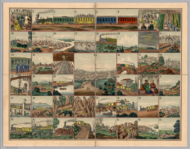
Date and author estimated, not indicated in the printed materials. An unusual board game based on the "new Union Pacific Railroad." The game board shows forty five beautifully executed views of places along the Union Pacific route, starting with "Rail road depot in New York" and ending in "San Francisco, the metropolis of California." Along the way, we have, among others, views of Pittsburgh, Omaha, "surprise by savage Indians," "wild heard of buffalloes," "railroad bridge over the Platte river," Cheyenne, Green River, Humboldt Valley, "Trukee" Valley, Sierra Nevada and Sacramento. The text is titled "Trip from New-York to San Francisco by the Union Pacific Rail Road. A new illustrated Travel-game with 45 stations, 1 dy, 12 cars and 12 numbers charts." The text is written in German and English and explains the game and the views. The cover of the game box (19x24) has a lovely colored litho view of two women joining hands across the American Continent, one representing America and the other Asia. Not in any of the standard game references - rare.
Author
Union Pacific Railroad Game
Full Title
The Voyage from New York to San Francisco upon the Union Pacific Railroad. El Viage De Nueva York A San Francisco Sobre el ferro-carril pacifico de los estados unidos. Reise von New-York nach San Francisco auf der Union-Pacific Bahn. Il viaggio di Nuova York a San Francisco sulla strada ferrata pacifica degli stati uniti. De reis van New-York na San-francisco op de Pacific-ijzerbaan van de vereenigte Staaten. Le voyage de New-york a San Francisco sur le chemin de fer pacific des etats unis.
List No
4781.002
Note
The game board. Date and author estimated, not indicated in the printed materials. An unusual board game based on the "new Union Pacific Railroad." The game board shows forty five beautifully executed views of places along the Union Pacific route, starting with "Rail road depot in New York" and ending in "San Francisco, the metropolis of California." Along the way, we have, among others, views of Pittsburgh, Omaha, "surprise by savage Indians," "wild heard of buffalloes," "railroad bridge over the Platte river," Cheyenne, Green River, Humboldt Valley, "Trukee" Valley, Sierra Nevada and Sacramento. The text is titled "Trip from New-York to San Francisco by the Union Pacific Rail Road. A new illustrated Travel-game with 45 stations, 1 dy, 12 cars and 12 numbers charts." The text is written in German and English and explains the game and the views. The cover of the game box (19x24) has a lovely colored litho view of two women joining hands across the American Continent, one representing America and the other Asia. Not in any of the standard game references - rare.
Author
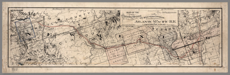
Atlantic & Pacific Railroad
Full Title
Map of the First Operating Division of the Western Division, Atlantic & Pacific R.R., From Albuquerque to Coolidge. Drawing No. J2-902. Lewis Kingman, Chief Engineer.
List No
6929.001
Note
A set of six hand-drawn maps on semi-transparent waxed linen with some color. Some areas are colored on the verso to highlight the areas in a muted style. We think that some type of backlighting was planned to be used to create a photolithographic plate from which printing would be done. No evidence was found that it was ever printed. These sheets were deaccessioned from the Santa Fe Railroad collection in the 1980s. Lewis Kingman did the route survey from Albuquerque to Needles. Relief shown by hachures. This sheet has colored lines on the verso to add color to the various areas depicted on the recto.
Author
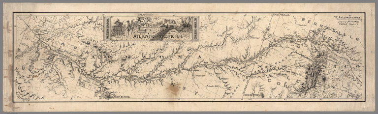
Atlantic & Pacific Railroad
Full Title
Map of the 2nd Operating Division of the Western Division, Atlantic & Pacific R.R., From Coolidge to Winslow. Drawing No. J-2-902.
List No
6929.002
Note
Lavishly illustrated title block. No drawing on verso. A set of six hand-drawn maps on semi-transparent waxed linen with some color. Some areas are colored on the verso to highlight the areas in a muted style. We think that some type of backlighting was planned to be used to create a photolithographic plate from which printing would be done. No evidence was found that it was ever printed. These sheets were deaccessioned from the Santa Fe Railroad collection in the 1980s. Lewis Kingman did the route survey from Albuquerque to Needles. Relief shown by hachures.
Author
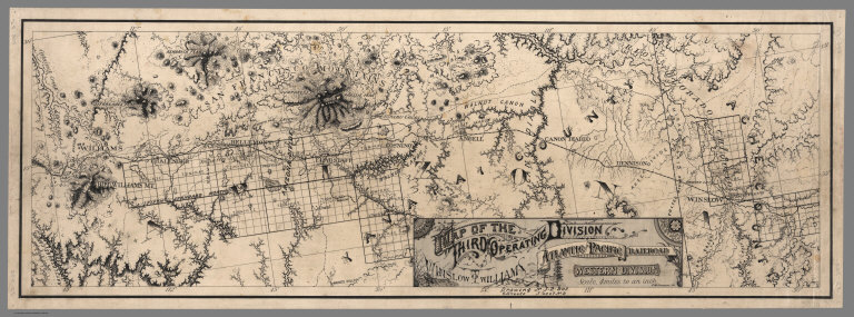
Atlantic & Pacific Railroad
Full Title
Map of the Third Operating Division of the Western Division, Atlantic & Pacific R.R., From From Winslow to Williams. Drawing No. J-2-902.
List No
6929.003
Note
Drawing on verso behind title block. A set of six hand-drawn maps on semi-transparent waxed linen with some color. Some areas are colored on the verso to highlight the areas in a muted style. We think that some type of backlighting was planned to be used to create a photolithographic plate from which printing would be done. No evidence was found that it was ever printed. These sheets were deaccessioned from the Santa Fe Railroad collection in the 1980s. Lewis Kingman did the route survey from Albuquerque to Needles. Relief shown by hachures.
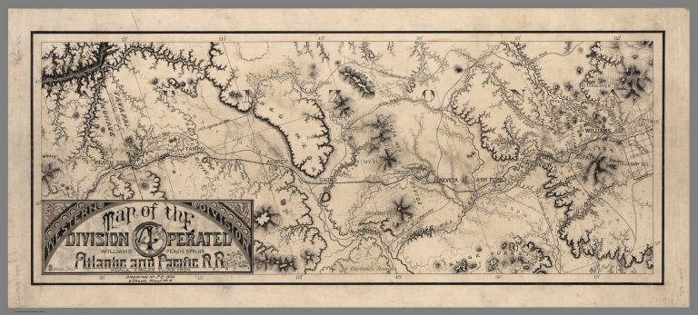
Author
Atlantic & Pacific Railroad
Full Title
Map of the 4th Operating Division of the Western Division, Atlantic & Pacific R.R., From Williams to Peach Springs. Drawing No. J-2-902.
List No
6929.004
Note
Drawing on verso behind title block. A set of six hand-drawn maps on semi-transparent waxed linen with some color. Some areas are colored on the verso to highlight the areas in a muted style. We think that some type of backlighting was planned to be used to create a photolithographic plate from which printing would be done. No evidence was found that it was ever printed. These sheets were deaccessioned from the Santa Fe Railroad collection in the 1980s. Lewis Kingman did the route survey from Albuquerque to Needles. Relief shown by hachures.
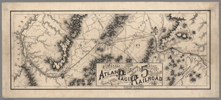
Author
Atlantic & Pacific Railroad
Full Title
Map of the 5th Operating Division of the Western Division, Atlantic & Pacific R.R., From Peach Springs to Needles. W.A. Drake, Acting Chief Engineer. Drawing No. J-2-902.
List No
6929.005
Note
No drawing on verso. A set of six hand-drawn maps on semi-transparent waxed linen with some color. Some areas are colored on the verso to highlight the areas in a muted style. We think that some type of backlighting was planned to be used to create a photolithographic plate from which printing would be done. No evidence was found that it was ever printed. These sheets were deaccessioned from the Santa Fe Railroad collection in the 1980s. Lewis Kingman did the route survey from Albuquerque to Needles. Relief shown by hachures.
Author
Atlantic & Pacific Railroad
Full Title
Map of the 6th Operating Division of the Western Division, Atlantic & Pacific R.R., From Needles to Mojave. Saml. M. Rowe, Resident Engineer. Drawing No. J-2-902.
List No
6929.006
Note
No drawing on verso. A set of six hand-drawn maps on semi-transparent waxed linen with some color. Some areas are colored on the verso to highlight the areas in a muted style. We think that some type of backlighting was planned to be used to create a photolithographic plate from which printing would be done. No evidence was found that it was ever printed. These sheets were deaccessioned from the Santa Fe Railroad collection in the 1980s. Lewis Kingman did the route survey from Albuquerque to Needles. Relief shown by hachures.
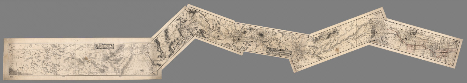
Author
Atlantic & Pacific Railroad
Full Title
(Composite of) Maps of the First through Sixth Operating Divisions of the Western Division, Atlantic & Pacific Railroad, Albuquerque, New Mexico, to Mojave (Mohave), California.
List No
6929.007
Note
Composite of all six maps joined together end to end. This is a set of six hand-drawn maps on semi-transparent waxed linen with some color. Some areas are colored on the verso to highlight the areas in a muted style. We think that some type of backlighting was planned to be used to create a photolithographic plate from which printing would be done. No evidence was found that it was ever printed. These sheets were deaccessioned from the Santa Fe Railroad collection in the 1980s. Lewis Kingman did the route survey from Albuquerque to Needles. Relief shown by hachures.
Author
Rand McNally and Company
Full Title
(Composite Map of) Rand, McNally & Co.'s New Shippers' Railroad Map of the United States. Scale: 8 miles to one inch. Showing all railroads, each in a separate color, and all railroad stations in large, plain type. This is the El Paso section only, of the above named map. (Below the neatline) Rand, McNally & Co.'s New Shippers' Railroad Map of the United States, Copyright, 1888 by Rand, McNally & Co. Copyright, 1891 by Rand, McNally & Co.
List No
5802.017
Note
This is a composite of all 13 maps. The owner of the 13 maps did not include the 2 western maps in this group for some reason, roughly Dakota and Indian Territory, or they may have been lost over time. Each set of these maps was made to order custom by Rand McNally so it is possible that these 13 maps comprise the entire set. The other 2 maps of the western US to the pacific are in the set but they are at a smaller scale so they are not in this composite image.
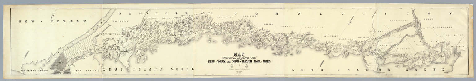
Author
Anderson, P.
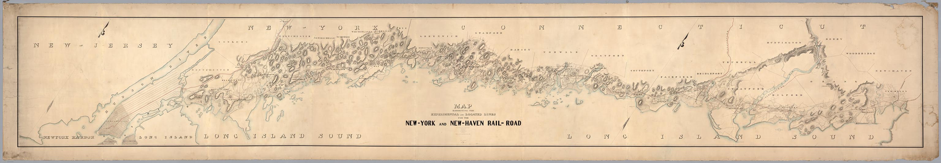
Full Title
Map Exhibiting The Experimental and Located Lines for the New-York and New-Haven Rail-Road ... Projected and Drawn by P. Anderson Civil Engr. Scale 1 to 20,000. Feb. 1845.
List No
6902.000
Note
This is probably the prepublication manuscript drawing for the final printed version of this map that was issued in the same year - see our 4218.000. It is twice the size and scale of the final printed version, and is beautifully hand drawn and colored. It is amazing that a map this large has survived outside of an institutional library for so long. Apparently it was kept in a family for several generations. It was leant to us by its current owner so that we could scan it and put it online. From our notes to the printed version: Greatly detailed strip map over twenty feet long showing the surveyed routes of the New York and New Haven Railroad. The line was opened in 1849. The map is unique for a railroad map in its huge size, large scale, elegance of drawing, and variety of information shown (houses, trails, rivers, turnpikes, lighthouses, harbors, hills, swamps, etc.).
Author
[Johnstone, E. McD., Southern Pacific Company]
Full Title
Climatic map of California. Published by the Southern Pacific Company. 1888. Compiled by E. McD. Johnstone, S.P. Co. From map prepared under the direction of Brig. Gen. H.C. Wright, Chief of Eng'rs. U.S.A. Lith H.S. Crocker & Co. S.F. Cal. Entered ... 1887, by the Southern Pacific Company ... Washington....
List No
0941.000
Note
Second ed.; 1st ed. was 1887. Relief shown by hachures. Shows the different temperature zones of the state by use of color. Also used as a promotional broadside for the Southern Pacific Railroad. Above the map reads "If You Intend To Travel Take The "Sunset Route" Of The Southern Pacific Company."
Author
Anderson, P.
Full Title
Map Exhibiting The Experimental and Located Lines for the New-York and New-Haven Rail-Road ... Projected and Drawn by P. Anderson Civil Engr. Scale 1 to 40,000. Febr. 1845. Snyder & Black Lithogrs. 87 Fulton St. New-York.
List No
4218.000
Note
Greatly detailed strip map over ten feet long showing the surveyed routes of the New York and New Haven Railroad. The line was opened in 1849. The map is unique for a railroad map in its huge size, large scale, elegance of drawing, and variety of information shown (houses, trails, rivers, turnpikes, lighthouses, harbors, hills, swamps, etc.).
Author
Tanner, Henry S.
Full Title
(Title Page to) A Connected View of The Whole Internal Navigation of the United States; ... Corrected and Improved From the Edition of 1826, And Much Enlarged, ... With A Sheet Map, ... The Map Has Been Engraved For the Purpose ... On A Reduced Scale, From Tanner's Excellent Four Sheet Map of the United States, Recently Published. ... By a Citizen of the United States. Philadelphia: Published by the Author ... Printed by Lydia R. Bailey. 1830. (on verso) ...on the seventeenth day of April ... 1830, George Armroyd ... hath deposited ... a Book ... Pennsylvania.
List No
3067A
Author
Tanner, Henry S.
Full Title
A Connected View of The Whole Internal Navigation of the United States; ... Corrected and Improved From the Edition of 1826, And Much Enlarged, ... With A Sheet Map, ... The Map Has Been Engraved For the Purpose ... On A Reduced Scale, From Tanner's Excellent Four Sheet Map of the United States, Recently Published. ... By a Citizen of the United States. Philadelphia: Published by the Author ... Printed by Lydia R. Bailey. 1830. (on verso) ...on the seventeenth day of April ... 1830, George Armroyd ... hath deposited ... a Book ... Pennsylvania.
List No
3067.001
Note
2nd (and best) edition, first with Tanner's Map of the Canals and Railroads of the United States. The map is copyright 1830. The book lists over 150 canals and navigation improvements in great detail. The map shows the most important canals and two railroads in operation, and one proposed railroad (the Great Western Railroad, from New York to the Mississippi River)plus two others. The canals and railroad lines are in color. The first edition appeared in 1826 with 10 maps but without the Tanner map (see our copy #4214). Tanner in 1834 and 1840 (see our copies, #2655 and #979) published a book on Canals and Railroads that uses the same map, updated. Modelski lists the 1834 Tanner map as "one of the earliest general maps of the eastern United States showing railroads in operation." Since this 1830 copy is an earlier state of the same map, it probably qualifies as the true "first." Two folding plates of profiles of canals and railroads at the back. Not in Streeter, Eberstadt, or Graff. Bound in half leather boards with "A Connected View" on the spine.
Author
Associated Railway Land Dept of Florida
Full Title
(Covers to) Township map of Peninsular Florida issued by the Associated Railway Land Department of Florida. 1890 ... Copyright, 1890, for the Associated Railway Land Department of Florida, By D.H. Elliott, General Land Agent. Matthews, Northrup & Co. Buffalo, New York.
List No
4100A
Note
Illustrated col. cover: Florida: map showing lands of the Associated Railway Land Department of Florida. Back cover: Florida: map illustrating its geographical position of the "Plant" and Jacksonville, Tampa & Key West systems.
Author
Associated Railway Land Dept of Florida
Full Title
(Title Page to) Township map of Peninsular Florida issued by the Associated Railway Land Department of Florida. 1890 ... Copyright, 1890, for the Associated Railway Land Department of Florida, By D.H. Elliott, General Land Agent. Matthews, Northrup & Co. Buffalo, New York.
List No
4100B
Note
List of companies and board of managers of the Department inside front cover.
Author
Associated Railway Land Dept of Florida
Full Title
Township map of Peninsular Florida issued by the Associated Railway Land Department of Florida. 1890 ... Copyright, 1890, for the Associated Railway Land Department of Florida, By D.H. Elliott, General Land Agent. Matthews, Northrup & Co., Buffalo, New York.
List No
4100.001
Note
Counties in outline color. Townships containing lands owned by the Department shown in green. Includes ill., diagram showing section numbering, etc. Prime meridian: Washington.
Author
Associated Railway Land Dept of Florida
Full Title
Map of North America and Western Europe showing the direct passenger transportation lines between Europe and the United States, Mexico, the West Indies, Central and South America, also illustrating the geographical position of Florida and location of the railroad, steamboat and steamship lines ... For commerce with other states and the countries south and east of the Gulf of Mexico. Copyright, 1889. Matthews, Northrup & Co. ... (inset map) Western Europe showing railways and steamship routes to America.
List No
4100.002
Note
Relief shown by hachures. Includes text and illus.
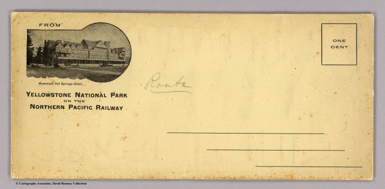
Author
Northern Pacific Railway Company
Full Title
(Covers to) The Yellowstone National Park on the Northern Pacific Railway. (1898)
List No
4118A
Note
Envelope with return address "From Yellowstone National Park on the Northern Pacific Railway" and shows a view of "Mammoth Hot Springs Hotel".
Author
Northern Pacific Railway Company
Full Title
(Covers to) The Yellowstone National Park via Northern Pacific Railway. Northern Pacific, Yellowstone Park Line. Puget Sound and Alaska.
List No
4118B
Note
Folded into self wrappers.
Author
Northern Pacific Railway Company
Full Title
(Text Page to) The Yellowstone National Park via Northern Pacific Railway. Northern Pacific, Yellowstone Park Line. Puget Sound and Alaska. (inset) Northern Pacific Railway and connections. Poole Bros., Chicago. (inset of steamship routes to southeastern Alaska from Puget Sound)
List No
4118C
Note
Two maps plus the photos and text regarding Yellowstone and Alaska.
Author
Northern Pacific Railway Company
Full Title
Yellowstone National Park. Northern Pacific Railway. Poole Bros., Chicago. Copyrighted, 1898, by Poole Bros., Chicago.
List No
4118.001
Note
Relief shown by shading and spot heights. Shows completed and proposed railroads. David Rumsey Collection copy: A traveler has marked his route around the park in red ink.
Author
Houston And Texas Central Railway
Full Title
(Covers to:) Houston and Texas Central Railway through Texas. Northern to southern boundary and with branches and Texas Central Railway through central and western Texas ... 461-July-85. Rand, McNally & Co., Printers, Chicago.
List No
5237A
Note
Self wrappers with text, view and timetable.
Author
Houston And Texas Central Railway
Full Title
Houston and Texas Central Railway through Texas. Northern to southern boundary and with branches and Texas Central Railway through central and western Texas ... 461-July-85. Rand, McNally & Co., Printers, Chicago.
List No
5237B
Note
Self wrappers with text, view and timetable.
Author
Houston And Texas Central Railway
Full Title
Texas and Mexico showing Houston and Texas Central system of railways. Rand, McNally & Co, Engr's, Chicago. (inset) Map of United States and Mexico reduced scale; showing the Houston and Texas Central Railway and connections. (1885)
List No
5237.001
Note
Col. map. Includes statistical table: Counties traversed by the Houston & Texas Central Railway
Author
Portland & Ogdensburg Railroad Company
Full Title
(Covers to) Portland & Ogdensburg Railroad. To and through the White Mountains to St. Johnsbury, Montpelier, Burlington, Montreal, Ogdensburg, Syracuse, and the West ... 7-26-79. Rand, Avery & Co., Railroad Printers, Boston.
List No
5264A
Author
Portland & Ogdensburg Railroad Company
Full Title
Map of the Portland & Ogdensburg Railroad and connections. Eng'd by Rand, Avery & Co., Boston. "7-26-79."
List No
5264.001
Note
Relief shown by hachures. Covers area from Portland to Buffalo and Ottawa to Newport, R.I. On sheet 38 x 40. Includes timetable and illus. self wrapper.
Author
Portland & Ogdensburg Railroad Company
Full Title
Topographical map of the White Mountains showing location of the Portland & Ogdensburg Railroad. (1879)
List No
5264.002
Note
Relief shown by hachures and spot heights. Includes drawing of "White Mt. Notch" in title, abbreviations and elevations for peaks in the White and Franconia mountains, chronology of the railroad, drawing of passenger car, and text.
Author
Atchison, Topeka, and Santa Fe Railroad Company
Full Title
(Covers to) Santa Fe. The Atchison, Topeka & Santa Fe Railway and connecting lines. Oct. 10, 1904.
List No
5281A
Author
Atchison, Topeka, and Santa Fe Railroad Company
Full Title
Santa Fe. Poole Bros., Chicago.
List No
5281.001
Note
Relief shown by hachures. Shows the Santa Fe Railway route from Chicago to San Francisco. Includes inset map of part of Mexico and "Profile of the Santa Fe, Chicago to California."
Author
Northern Pacific Railroad Company
Full Title
(Covers to) Map showing land grant of the Northern Pacific Railroad Co. in Western Washington and Northern Oregon. Corrected up to August 20, 1888 ... Matthews, Northrup & Co., Art-Printing Works, Buffalo, N.Y.
List No
5392A
Note
"Northern Pacific Country. View of Tacoma, Washington Territory. The Pacific Coast terminus of the Northern Pacific Railroad." Back cover: ... Ths sectional land map of western and central Washington ...
Author
Northern Pacific Railroad Company
Full Title
(Text Page to) Map showing land grant of the Northern Pacific Railroad Co. in Western Washington and Northern Oregon. Corrected up to August 20, 1888 ... Matthews, Northrup & Co., Art-Printing Works, Buffalo, N.Y.
List No
5392B
Note
3 p. on 1 sheet. Text, illustrations, "Map Of Washington, Northern Idaho & Oregon. Rand, McNally & Co., Chicago," fare table, climate tables, etc. Text entitled: Sectional land map showing the lands of the Northern Pacific Railroad Co. in Western Washington and Northern Oregon, with condensed information relating to the Northern Pacific country.
Author
Northern Pacific Railroad Company
Full Title
Map showing land grant of the Northern Pacific Railroad Co. in Western Washington and Northern Oregon. Corrected up to August 20, 1888 ... Matthews, Northrup & Co., Art-Printing Works, Buffalo, N.Y. (inset map) Northern Pacific Railroad and connections.
List No
5392.001
Note
Relief shown by hachures and spot heights. Shows lands and lands sold or transferred by N.P.R.R. and U.S. government, school sections, navigation line, mineral deposits, railroads, etc.
Author
Andreas, A. T. (Alfred Theodore), 1839-1900
Full Title
New railroad map of the United States, the Dominion of Canada, Mexico and the West Indies. (Published by the Andreas Atlas Co., Lakeside Building, Chicago, Ills. Engraved & printed by Chas. Shober & Co., Props. of Chicago Lithographing Co.)
List No
0018.012
Note
Hand col. lithographed map. Relief shown by hachures. Title includes view. Prime meridians: Washington and Greenwich.
Author
[Andreas, A. T. (Alfred Theodore), 1839-1900, Baskin, Forster and Company]
Full Title
New railroad map of the United States and Dominion of Canada. (Published by Baskin, Forster & Co. Lakeside Building Chicago, Ills. 1876. Engraved & Printed by Chas. Shober & Co. Props. of Chicago Lithographing Co.)
List No
0019.006
Note
Lithographed map. Hand col. Relief shown by hachures. Includes farm scene below title.
Author
Breese, Sidney
Full Title
(Title Page to) Reports of Committees, Printed by Order of the Senate of the United States, during the Second Session of the Thirtieth Congress, begun and held at the City of Washington, December 4, 1848 ... Containing Reports from No. 244 to No. 331. Washington: 1849. Accompanied with Skeleton Map Showing the Railroads completed and in Progress in the United States, and those projected through the Public Lands and their connection with the principal Harbours on the Lakes and on the Seaboard. Printed by order of the Senate of the United States the 9th Sess: 31st Congress 1848-9.
List No
0091.001
Note
Very early U.S. Gov't Railroad Map. With proposed and existing railway lines in color. Bound with the "Reports of Committees, Printed by Order of the Senate of the United States, during the Second Session of the Thirtieth Congress, begun and held at the City of Washington, December 4, 1848 ... Containing Reports from No. 244 to No. 331. Washington: 1849." In full leather covers 23x15 with "Senate Reports 2d S. 30th C." on spine.
Author
Breese, Sidney
Full Title
(Text Page to) Report: In Senate of the United States. December 19, 1848 ... Mr. Breese made the following Report (to accompany bill S. No. 355.) 30 Congress, 2nd Session, Rep. Com., No. 244. (at head of title) Senate. (to accompany) Reports of Committees, Printed by Order of the Senate of the United States, during the Second Session of the Thirtieth Congress, begun and held at the City of Washington, December 4, 1848 ... Containing Reports from No. 244 to No. 331. Washington: 1849. Accompanied with Skeleton Map Showing the Railroads completed and in Progress in the United States, and those projected through the Public Lands and their connection with the principal Harbours on the Lakes and on the Seaboard. Printed by order of the Senate of the United States the 9th Sess: 31st Congress 1848-9.
List No
0091.002
Note
Very early U.S. Gov't Railroad Map. With proposed and existing railway lines in color. Bound with the "Reports of Committees, Printed by Order of the Senate of the United States, during the Second Session of the Thirtieth Congress, begun and held at the City of Washington, December 4, 1848 ... Containing Reports from No. 244 to No. 331. Washington: 1849." In full leather covers 23x15 with "Senate Reports 2d S. 30th C." on spine.
Author
Breese, Sidney
Full Title
(Text Page to) Report: In Senate of the United States. December 19, 1848 ... Mr. Breese made the following Report (to accompany bill S. No. 355.) 30 Congress, 2nd Session, Rep. Com., No. 244. (at head of title) Senate. (to accompany) Reports of Committees, Printed by Order of the Senate of the United States, during the Second Session of the Thirtieth Congress, begun and held at the City of Washington, December 4, 1848 ... Containing Reports from No. 244 to No. 331. Washington: 1849. Accompanied with Skeleton Map Showing the Railroads completed and in Progress in the United States, and those projected through the Public Lands and their connection with the principal Harbours on the Lakes and on the Seaboard. Printed by order of the Senate of the United States the 9th Sess: 31st Congress 1848-9.
List No
0091.003
Note
Very early U.S. Gov't Railroad Map. With proposed and existing railway lines in color. Bound with the "Reports of Committees, Printed by Order of the Senate of the United States, during the Second Session of the Thirtieth Congress, begun and held at the City of Washington, December 4, 1848 ... Containing Reports from No. 244 to No. 331. Washington: 1849." In full leather covers 23x15 with "Senate Reports 2d S. 30th C." on spine.
Author
Breese, Sidney
Full Title
(Text Page to) Report: In Senate of the United States. December 19, 1848 ... Mr. Breese made the following Report (to accompany bill S. No. 355.) 30 Congress, 2nd Session, Rep. Com., No. 244. (at head of title) Senate. (to accompany) Reports of Committees, Printed by Order of the Senate of the United States, during the Second Session of the Thirtieth Congress, begun and held at the City of Washington, December 4, 1848 ... Containing Reports from No. 244 to No. 331. Washington: 1849. Accompanied with Skeleton Map Showing the Railroads completed and in Progress in the United States, and those projected through the Public Lands and their connection with the principal Harbours on the Lakes and on the Seaboard. Printed by order of the Senate of the United States the 9th Sess: 31st Congress 1848-9.
List No
0091.004
Note
Very early U.S. Gov't Railroad Map. With proposed and existing railway lines in color. Bound with the "Reports of Committees, Printed by Order of the Senate of the United States, during the Second Session of the Thirtieth Congress, begun and held at the City of Washington, December 4, 1848 ... Containing Reports from No. 244 to No. 331. Washington: 1849." In full leather covers 23x15 with "Senate Reports 2d S. 30th C." on spine.
|