|
Author
Cram, George Franklin, 1841-1928
Full Title
Chile, Argentine Republic and Uruguay.
List No
14372.314
Note
Map of Chile, Argentina and Uruguay. Shows political boundaries, cities, railroads, topography, bodies of water, drainage, coastlines and islands. Relief shown with hachures. Includes latitudinal and longitudinal lines, as well as a bar scale given in miles. Provides figures for square milage and population. Inset map: Northern part of Chile. Map indexed to indicate place names. Colored lithograph. Map is 55 x 40 cm, on double sheet 67 x 45 cm.
Author
Cram, George Franklin, 1841-1928
Full Title
France.
List No
14372.317
Note
Map of France. Shows political boundaries, cities, railroads, submarine telegraph lines, topography, bodies of water, drainage, coastlines and islands. Relief shown with hachures. Includes latitudinal and longitudinal lines, as well as a bar scale given in miles. Provides figures for square milage and population. Inset map: Corsica. Map indexed to indicate place names. Colored lithograph. Map is 26 x 39 cm, on sheet 33 x 45 cm.
Author
Cram, George Franklin, 1841-1928
Full Title
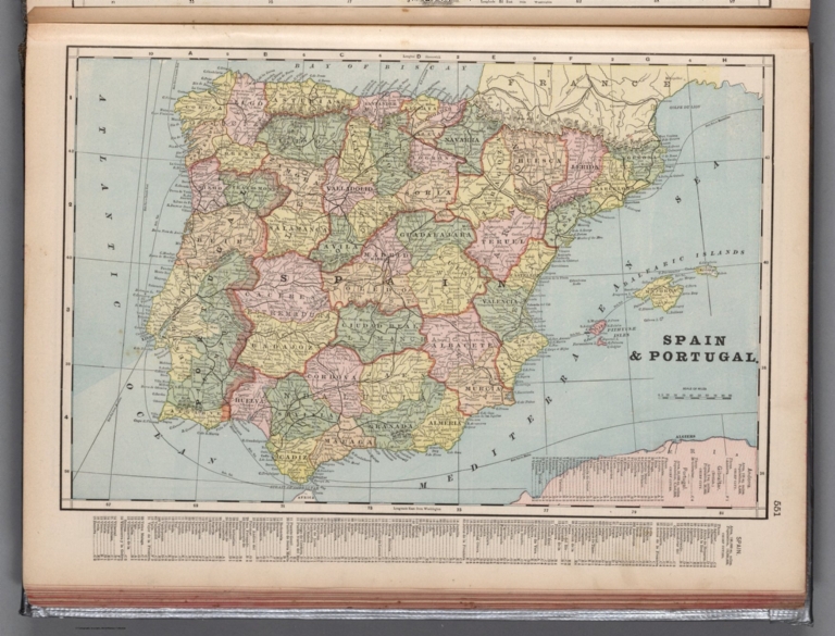
Spain & Portugal.
List No
14372.318
Note
Map of Spain and Portugal. Shows political boundaries, cities, railroads, submarine telegraph lines, topography, bodies of water, drainage, coastlines and islands. Relief shown with hachures. Includes latitudinal and longitudinal lines, as well as a bar scale given in miles. Provides figures for square milage and population. Map indexed to indicate place names. Colored lithograph. Map is 26 x 40 cm, on sheet 33 x 45 cm.
Author
Cram, George Franklin, 1841-1928
Full Title
Europe.
List No
14372.319
Note
Map of Europe. Shows political boundaries, cities, railroads, submarine telegraph lines, topography, bodies of water, drainage, coastlines and islands. Relief shown with hachures. Includes latitudinal and longitudinal lines, as well as a bar scale given in miles. Provides figures for square milage and population. Map indexed to indicate place names. Colored lithograph. Map is 40 x 53 cm, on double sheet 45 x 67 cm.
Author
Cram, George Franklin, 1841-1928
Full Title
Italy.
List No
14372.320
Note
Map of Italy. Shows political boundaries, cities, railroads, submarine telegraph lines, topography, bodies of water, drainage, coastlines and islands. Relief shown with hachures. Includes latitudinal and longitudinal lines, as well as a bar scale given in miles. Provides figures for square milage and population. Map indexed to indicate place names. Colored lithograph. Map is 40 x 28 cm, on sheet 45 x 33 cm.
Author
Cram, George Franklin, 1841-1928
Full Title
Corsica and Sardinia.
List No
14372.321
Note
Map of Corsica and Sardinia. Shows political boundaries, cities, railroads, submarine telegraph lines, topography, bodies of water, drainage, coastlines and islands. Relief shown with hachures. Includes latitudinal and longitudinal lines, as well as a bar scale given in miles. Colored lithograph. Map is 41 x 26 cm, on sheet 45 x 33 cm.
Author
Cram, George Franklin, 1841-1928
Full Title
England and Wales.
List No
14372.322
Note
Map of England and Wales. Shows political boundaries, cities, railroads, topography, bodies of water, drainage, coastlines and islands. Relief shown with hachures. Includes latitudinal and longitudinal lines, as well as a bar scale given in miles. Provides figures for square milage and population. Map indexed to indicate place names. Colored lithograph. Map is 51 x 41 cm, on double sheet 67 x 45 cm.
Author
Cram, George Franklin, 1841-1928
Full Title
Greece.
List No
14372.323
Note
Map of Greece. Shows political boundaries, cities, railroads, submarine telegraph lines, topography, bodies of water, drainage, coastlines and islands. Relief shown with hachures. Includes latitudinal and longitudinal lines, as well as a bar scale given in miles. Provides figures for square milage and population. Two inset maps: Corfu & Paxo -- The Cyclades. Map indexed to indicate place names. Colored lithograph. Map is 39 x 26 cm, on sheet 45 x 33 cm.
Author
Cram, George Franklin, 1841-1928
Full Title
Austro-Hungarian.
List No
14372.324
Note
Map of the Austro-Hungarian Empire. Shows political boundaries, cities, railroads, topography, bodies of water, drainage, coastlines and islands. Relief shown with hachures. Includes latitudinal and longitudinal lines, as well as a bar scale given in miles. Provides figures for square milage and population. Inset map: Continuation of Dalmatia &c. Map indexed to indicate place names. Colored lithograph. Map is 27 x 40 cm, on sheet 33 x 45 cm.
Author
Cram, George Franklin, 1841-1928
Full Title
Scotland.
List No
14372.325
Note
Map of Scotland. Shows political boundaries, cities, railroads, topography, bodies of water, drainage, coastlines and islands. Relief shown with hachures. Includes latitudinal and longitudinal lines, as well as a bar scale given in miles. Provides figures for square milage and population. Map indexed to indicate place names. Colored lithograph. Map is 52 x 41 cm, on double sheet 67 x 45 cm.
Author
Cram, George Franklin, 1841-1928
Full Title
Belgium and the Netherlands.
List No
14372.326
Note
Map of Belgium and the Netherlands. Shows political boundaries, cities, railroads, submarine telegraph lines, bodies of water, drainage, coastlines and islands. Includes latitudinal and longitudinal lines, as well as a bar scale given in miles. Provides figures for square milage and population. Map indexed to indicate place names. Colored lithograph. Map is 39 x 27 cm, on sheet 45 x 33 cm.
Author
Cram, George Franklin, 1841-1928
Full Title
Denmark.
List No
14372.327
Note
Map of Denmark. Shows political boundaries, cities, railroads, submarine telegraph lines, bodies of water, drainage, coastlines and islands. Includes latitudinal and longitudinal lines, as well as a bar scale given in miles. Provides figures for square milage and population. Map indexed to indicate place names. Three inset maps: Iceland -- Faroe Is. -- Sandvig. Colored lithograph. Map is 39 x 26 cm, on sheet 45 x 33 cm.
Author
Cram, George Franklin, 1841-1928
Full Title
Ireland.
List No
14372.328
Note
Map of Ireland. Shows political boundaries, cities, railroads, topography, bodies of water, drainage, coastlines and islands. Relief shown with hachures. Includes latitudinal and longitudinal lines, as well as a bar scale given in miles. Provides figures for square milage and population. Map indexed to indicate place names. Colored lithograph. Map is 53 x 42 cm, on double sheet 67 x 45 cm.
Author
Cram, George Franklin, 1841-1928
Full Title
Iceland -- Greenland -- The Faroer or Feroe Islands.
List No
14372.329
Note
Three maps of Iceland, Greenland and the Feroe Islands. Maps show political boundaries, cities, railroads, topography, bodies of water, drainage, coastlines and islands. Relief shown with hachures. Maps include latitudinal and longitudinal lines, as well as a bar scale given in miles (scales differ). Colored lithograph. Together, maps are 40 x 32 cm, on sheet 45 x 33 cm.
Author
Cram, George Franklin, 1841-1928
Full Title
Sweden & Norway.
List No
14372.330
Note
Map of Sweden and Norway. Shows political boundaries, cities, railroads, topography, bodies of water, drainage, coastlines and islands. Relief shown with hachures. Includes latitudinal and longitudinal lines, as well as a bar scale given in miles. Provides figures for square milage and population. Map indexed to indicate place names. Colored lithograph. Map is 39 x 26 cm, on sheet 45 x 33 cm.
Author
Cram, George Franklin, 1841-1928
Full Title
Switzerland.
List No
14372.331
Note
Map of Switzerland. Shows political boundaries, cities, railroads, topography, bodies of water, drainage, shorelines and islands. Relief shown with hachures and pictorially. Includes latitudinal and longitudinal lines, as well as a bar scale given in miles. Provides figures for square milage and population. Map indexed to indicate place names. Colored lithograph. Map is 39 x 56 cm, on double sheet 45 x 67 cm.
Author
Cram, George Franklin, 1841-1928
Full Title
Russia.
List No
14372.332
Note
Map of Russia. Shows political boundaries, cities, railroads, topography, bodies of water, drainage, coastlines and islands. Relief shown with hachures. Includes latitudinal and longitudinal lines, as well as a bar scale given in miles. Provides figures for square milage and population. Map indexed to indicate place names. Colored lithograph. Map is 40 x 26 cm, on sheet 45 x 33 cm.
Author
Cram, George Franklin, 1841-1928
Full Title
Turkey in Europe, Bulgaria, Montenegro, Roumania and Servia.
List No
14372.333
Note
Map of Turkey in Europe, as well as Bulgaria, Montenegro, Romania and Serbia. Shows political boundaries, cities, railroads, topography, bodies of water, drainage, coastlines and islands. Relief shown with hachures. Includes latitudinal and longitudinal lines, as well as a bar scale given in miles. Provides figures for square milage and population. Map indexed to indicate place names. Inset map: Crete or Candia. Colored lithograph. Map is 27 x 39 cm, on sheet 33 x 45 cm.
Author
Cram, George Franklin, 1841-1928
Full Title
Germany.
List No
14372.334
Note
Map of Germany. Shows political boundaries, cities, railroads, submarine telegraph lines, topography, bodies of water, drainage, shorelines, islands and water routes with distances. Relief shown with hachures. Includes latitudinal and longitudinal lines, as well as a bar scale given in miles. Provides figures for square milage and population. Map indexed to indicate place names. Colored lithograph. Map is 41 x 54 cm, on double sheet 45 x 67 cm.
Author
Cram, George Franklin, 1841-1928
Full Title
Cyprus.
List No
14372.335
Note
Map of Cyprus. Shows political boundaries, cities, railroads, topography, bodies of water, drainage, coastlines and islands. Relief shown with hachures. Includes latitudinal and longitudinal lines, as well as a bar scale given in miles. Provides figures for square milage and population. Map indexed to indicate place names. Inset map: Crete or Candia. Colored lithograph. Map is 25 x 34 cm, on sheet 33 x 45 cm.
Author
Cram, George Franklin, 1841-1928
Full Title
Central Asia, comprising Afghanistan, Baluchistan, Bokhara, Khiva & Turkestan.
List No
14372.336
Note
Map of Central Asia, comprising Afghanistan, the Balochistan Region (Pakistan), Bukhara, Khiva (Uzbekistan) and Turkestan. Shows political boundaries, cities, railroads, topography, bodies of water, drainage, coastlines and islands. Relief shown with hachures. Includes latitudinal and longitudinal lines, as well as a bar scale given in miles. Provides figures for square milage and population. Map indexed to indicate place names. Colored lithograph. Map is 40 x 25 cm, on sheet 45 x 33 cm.
Author
Cram, George Franklin, 1841-1928
Full Title
Asia.
List No
14372.337
Note
Map of Asia. Shows political boundaries, cities, railroads, submarine telegraph lines, topography, bodies of water, drainage, shorelines and islands. Relief shown with hachures. Includes latitudinal and longitudinal lines, as well as a bar scale given in miles. Provides figures for square milage and population. Map indexed to indicate place names. Colored lithograph. Map is 39 x 52 cm, on double sheet 45 x 67 cm.
Author
Cram, George Franklin, 1841-1928
Full Title
India.
List No
14372.338
Note
Map of India. Shows political boundaries, cities, railroads, topography, bodies of water, drainage, coastlines and islands. Relief shown with hachures. Includes latitudinal and longitudinal lines, as well as a bar scale given in miles. Provides figures for square milage and population. Map indexed to indicate place names. Inset map: South eastern provinces of India (or Further India). Colored lithograph. Map is 40 x 27 cm, on sheet 45 x 33 cm.
Author
Cram, George Franklin, 1841-1928
Full Title
China.
List No
14372.339
Note
Map of China. Shows political boundaries, cities, railroads, topography, bodies of water, drainage, coastlines and islands. Relief shown with hachures. Includes latitudinal and longitudinal lines, as well as a bar scale given in miles. Provides figures for square milage and population. Map indexed to indicate place names. Inset map: Islands of Japan. Colored lithograph. Map is 26 x 39 cm, on sheet 33 x 45 cm.
Author
Cram, George Franklin, 1841-1928
Full Title
Japan.
List No
14372.340
Note
Map of Japan. Shows political boundaries, cities, railroads, topography, bodies of water, drainage, coastlines and islands. Relief shown with hachures. Includes latitudinal and longitudinal lines, as well as a bar scale given in miles. Provides figures for square milage and population. Map indexed to indicate place names. Colored lithograph. Map is 53 x 44 cm, on double sheet 67 x 45 cm.
Author
Cram, George Franklin, 1841-1928
Full Title
Persia.
List No
14372.341
Note
Map of Persia [present-day Iran]. Shows political boundaries, cities, railroads, topography, deserts, bodies of water, drainage, coastlines and islands. Relief shown with hachures. Includes latitudinal and longitudinal lines, as well as a bar scale given in miles. Provides figures for square milage and population. Map indexed to indicate place names. Colored lithograph. Map is 24 x 30 cm, on sheet 33 x 45 cm.
Author
Cram, George Franklin, 1841-1928
Full Title
Turkish Empire in Europe and Asia, Greece, Roumania, ect.
List No
14372.342
Note
Map of the Turkish [Ottoman] Empire in Europe, Asia, Greece and Romania. Shows political boundaries, cities, railroads, topography, bodies of water, drainage, coastlines and islands. Relief shown with hachures. Includes latitudinal and longitudinal lines, as well as a bar scale given in miles. Provides figures for square milage and population. Map indexed to indicate place names. Colored lithograph. Map is 24 x 30 cm, on sheet 33 x 45 cm.
Author
Cram, George Franklin, 1841-1928
Full Title
East Indies. Geo. F. Cram, engraver and publisher, Chicago, Ill.
List No
14372.343
Note
Map of the East Indies. Shows political boundaries, cities, railroads, submarine telegraph lines, topography, bodies of water, drainage, coastlines, islands and water routes with distances and explanatory notes. Relief shown with hachures. Includes latitudinal and longitudinal lines, as well as a bar scale given in miles. Provides figures for square milage and population. Map indexed to indicate place names. Colored lithograph. Map is 41 x 56 cm, on double sheet 45 x 67 cm.
Author
Cram, George Franklin, 1841-1928
Full Title
Sumatra -- Java.
List No
14372.344
Note
Two maps of Sumatra and Java, Indonesia. Maps show political boundaries, cities, railroads, topography, bodies of water, drainage, coastlines and islands. Relief shown with hachures. Maps include latitudinal and longitudinal lines, as well as bar scales given in miles (scales differ). Maps provide figures for square milage and population. Colored lithograph. Together, maps are 29 x 39 cm, on sheet 45 x 33 cm.
Author
Cram, George Franklin, 1841-1928
Full Title
Palestine.
List No
14372.345
Note
Map of Palestine. Shows political boundaries, cities, railroads, roads, pilgrimage routes, topography, bodies of water, drainage, coastlines and islands. Relief shown with hachures. Includes latitudinal and longitudinal lines, as well as a bar scale given in miles. Provides figures for square milage and population. Map indexed to indicate place names. With "Explanation of words of frequent occurrence" such as "Jebel" for mountain. Colored lithograph. Map is 40 x 27 cm, on sheet 45 x 33 cm.
Author
Cram, George Franklin, 1841-1928
Full Title
Northwest Africa, Morocco, Algeria and Tunis.
List No
14372.347
Note
Map of Northwest Africa, including Morocco, Algeria and Tunis (Tunisia). Shows political boundaries, cities, railroads, submarine telegraph lines, topography, deserts, bodies of water, drainage, coastlines, islands and water routes. Relief shown with hachures. Includes latitudinal and longitudinal lines, as well as a bar scale given in miles. Provides figures for square milage and population. Map indexed to indicate place names. Colored lithograph. Map is 24 x 32 cm, on sheet 33 x 45 cm.
Author
Cram, George Franklin, 1841-1928
Full Title
Africa.
List No
14372.348
Note
Map of Africa. Shows political boundaries, cities, railroads, topography, deserts, bodies of water, drainage, coastlines and islands. Relief shown with hachures. Includes a legend showing European colonial possessions, latitudinal and longitudinal lines, as well as a bar scale given in miles. Provides figures for square milage and population. Map indexed to indicate place names. Colored lithograph. Map is 39 x 35 cm, on double sheet 67 x 45 cm.
Author
Cram, George Franklin, 1841-1928
Full Title
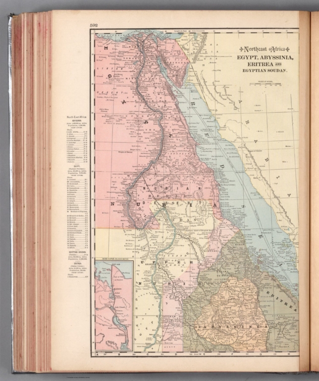
Northeast Africa, Egypt, Abyssinia, Eritrea and Egyptian Soudan.
List No
14372.349
Note
Map of Northwest Africa, including Egypt, Abyssinia [present-day Ethiopia], Eritrea and Egyptian Sudan [present-day Sudan]. Shows political boundaries, cities, railroads, submarine telegraph lines, topography, deserts, bodies of water, drainage, coastlines, islands and water routes with distances. Relief shown with hachures. Includes latitudinal and longitudinal lines, as well as a bar scale given in miles and explanatory notes throughout. Provides figures for square milage and population. Map indexed to indicate place names. Inset map: Suez Canal. Colored lithograph. Map is 41 x 26 cm, on sheet 45 x 33 cm.
Author
Cram, George Franklin, 1841-1928
Full Title
South Africa, Cape Colony, Natal, Orange Free State and South African Republic.
List No
14372.350
Note
Map of Southern Africa, including South Africa. Shows political boundaries, cities, railroads, submarine telegraph lines, topography, deserts, bodies of water, drainage, coastlines, islands and water routes with distances. Relief shown with hachures and peak heights. Includes latitudinal and longitudinal lines, as well as a bar scale given in miles and explanatory notes throughout. Provides figures for square milage and population. Map indexed to indicate place names. olored lithograph. Map is 23 x 31 cm, on sheet 45 x 33 cm.
Author
Cram, George Franklin, 1841-1928
Full Title
Central Africa.
List No
14372.351
Note
Map of Central Africa. Shows political boundaries, cities, railroads, topography, deserts, bodies of water, drainage, coastlines and islands. Relief shown with hachures. Includes latitudinal and longitudinal lines, as well as a bar scale given in miles and explanatory notes throughout. Provides figures for square milage and population. Map indexed to indicate place names. Colored lithograph. Map is 42 x 53 cm, on double sheet 45 x 67 cm.
Author
Cram, George Franklin, 1841-1928
Full Title
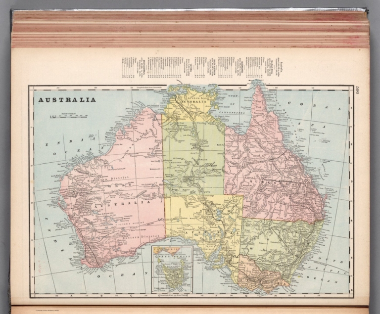
Australia.
List No
14372.352
Note
Map of Australia. Shows political boundaries, cities, railroads, submarine telegraph lines, topography, bodies of water, drainage, coastlines and islands. Relief shown with hachures and peak heights. Includes latitudinal and longitudinal lines, as well as a bar scale given in miles. Provides figures for square milage and population. Map indexed to indicate place names. Inset map: Tasmania. Colored lithograph. Map is 27 x 40 cm, on sheet 33 x 45 cm.
Author
Cram, George Franklin, 1841-1928
Full Title
Tasmania or Van Diemen's Land.
List No
14372.353
Note
Map of Tasmania, Australia. Shows political boundaries, cities, railroads, submarine telegraph lines, topography, bodies of water, drainage, coastlines and islands. Relief shown with hachures and peak heights. Includes latitudinal and longitudinal lines, as well as a bar scale given in miles. Provides figures for square milage and population. Map indexed to indicate place names. Colored lithograph. Map is 40 x 29 cm, on sheet 45 x 33 cm.
Author
Cram, George Franklin, 1841-1928
Full Title
Map of New South Wales.
List No
14372.354
Note
Map of New South Wales, Australia. Shows political boundaries, cities, railroads, topography, bodies of water, drainage, coastlines and islands. Relief shown with hachures. Includes latitudinal and longitudinal lines, as well as a bar scale given in miles. Provides figures for square milage and population. Map indexed to indicate place names. Inset map: Sydney and vicinity. Colored lithograph. Map is 41 x 55 cm, on double sheet 45 x 67 cm.
Author
Cram, George Franklin, 1841-1928
Full Title
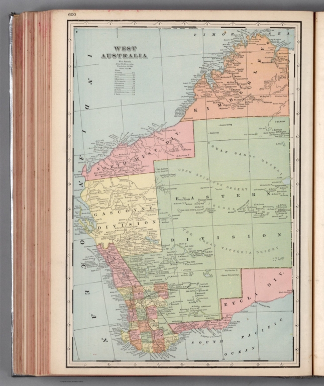
West Australia.
List No
14372.355
Note
Map of Western Australia. Shows political boundaries, cities, railroads, topography, deserts, bodies of water, drainage, coastlines and islands. Relief shown with hachures. Includes latitudinal and longitudinal lines, as well as a bar scale given in miles. Provides figures for square milage and population. Map indexed to indicate place names. Colored lithograph. Map is 41 x 27 cm, on sheet 45 x 33 cm.
Author
Cram, George Franklin, 1841-1928
Full Title
Queensland.
List No
14372.356
Note
Map of Queensland, Australia. Shows political boundaries, cities, railroads, topography, bodies of water, drainage, coastlines and islands. Relief shown with hachures. Includes latitudinal and longitudinal lines, as well as a bar scale given in miles. Provides figures for square milage and population. Map indexed to indicate place names. Colored lithograph. Map is 40 x 27 cm, on sheet 45 x 33 cm.
Author
Cram, George Franklin, 1841-1928
Full Title
Map of Victoria.
List No
14372.357
Note
Map of Victoria, Australia. Shows political boundaries, cities, railroads, topography, bodies of water, drainage, coastlines and islands. Relief shown with hachures. Includes latitudinal and longitudinal lines, as well as a bar scale given in miles. Provides figures for square milage and population. Map indexed to indicate place names. Colored lithograph. Map is 39 x 57 cm, on double sheet 45 x 67 cm.
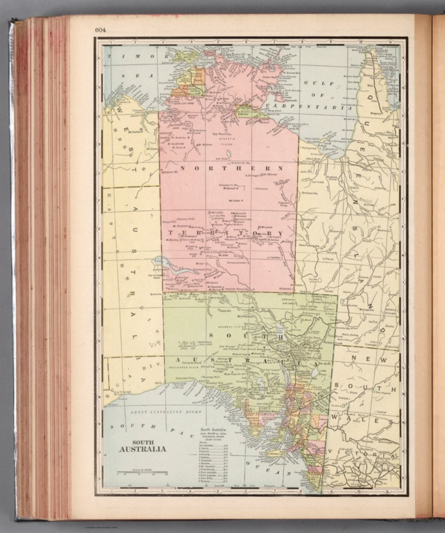
Author
Cram, George Franklin, 1841-1928
Full Title
South Australia.
List No
14372.358
Note
Map of Southern Australia. Shows political boundaries, cities, railroads, topography, bodies of water, drainage, coastlines and islands. Relief shown with hachures. Includes latitudinal and longitudinal lines, as well as a bar scale given in miles. Provides figures for square milage and population. Map indexed to indicate place names. Colored lithograph. Map is 40 x 27 cm, on sheet 45 x 33 cm.
Author
Cram, George Franklin, 1841-1928
Full Title
Map of New Guinea.
List No
14372.359
Note
Map of New Guinea. Shows political boundaries, cities, railroads, topography, bodies of water, drainage, coastlines and islands. Relief shown with hachures. Includes latitudinal and longitudinal lines, as well as a bar scale given in miles. Provides figures for square milage and population. Map indexed to indicate place names. Inset map: Part of South Coast of New Guinea. Colored lithograph. Map is 27 x 42 cm, on sheet 33 x 45 cm.
Author
Cram, George Franklin, 1841-1928
Full Title
New Zealand.
List No
14372.360
Note
Map of New Zealand. Shows political boundaries, cities, railroads, topography, bodies of water, drainage, coastlines and islands. Relief shown with hachures. Includes latitudinal and longitudinal lines, as well as a bar scale given in miles. Provides figures for square milage and population. Map indexed to indicate place names. Inset map: Chatham Islands. Colored lithograph. Map is 57 x 39 cm, on double sheet 67 x 45 cm.
Association universitaire de recherches ... Voies ferrées : Trafic voyageurs, 1965 .... 1965 14397.038 Related Author
[Association universitaire de recherches cartographiques et géographiques, France. Délégation à l'aménagement du territoire et à l'action régionale, Association universitaire de recherches et d'études géographiques]
Full Title
Voies ferrées : Trafic voyageurs, 1965 -- Autobus de la R.A.T.P., 1964 -- Routes nationales : Circulation en 1960 -- Transports routiers privés de voyageurs, 1-4-1964. A.U.R.E.G.
List No
14397.038
Note
Four maps of transportation in the Région Parisienne [Île-de-France], or the Paris Region, France, from 1960 to 1965. Maps show railways, bus routes, national roads and private roads. Maps include legends and bar scales. Colored lithograph. Together, maps are 51 x 64 cm, on sheet 56 x 69 cm. "Transports et énergie 51-3".
Association universitaire de recherches ... Voies ferrées : Trafic merchandises, 196... 1965 14397.039 Related Author
[Association universitaire de recherches cartographiques et géographiques, France. Délégation à l'aménagement du territoire et à l'action régionale, Association universitaire de recherches et d'études géographiques]
Full Title
Voies ferrées : Trafic merchandises, 1963 -- Gares : Trafic merchandises, 1963 -- Voies navigables : Trafic merchandises, 1964 -- Les ports de Paris : Trafic merchandises, 1965. A.U.R.E.G.
List No
14397.039
Note
Five maps of transportation in the Région Parisienne [Île-de-France], or the Paris Region, France, from 1963 to 1965. Maps show the traffic of goods along railways and through railway stations, as well as via waterways and the ports of Paris. Maps include legends and bar scales (scales differ). Colored lithograph. Together, maps are 51 x 64 cm, on sheet 56 x 69 cm. "Transports et énergie 51-4".
Association universitaire de recherches ... Paris - Lyon - Marseille - Nice : TEmps ... 1965 14397.040 Related Author
[Association universitaire de recherches cartographiques et géographiques, France. Délégation à l'aménagement du territoire et à l'action régionale, Association universitaire de recherches et d'études géographiques]
Full Title
Paris - Lyon - Marseille - Nice : Temps de parcours comparés -- Paris - Toulouse : Temps de parcours comparés -- Paris - Brest : Temps de parcours comparés -- Temps de parcours entre Paris et les principales villes : en 1920 -- en 1938 -- en 1954 -- en 1965 -- S.N.C.F. - Trafic voyageurs en 1965 : Grandes lignes -- Flux téléphoniques en 1965 -- Mouvements d'aéronefs des aérodromes dépendant de l'aéroport de Paris, 1964. A.U.R.E.G.
List No
14397.040
Note
Three charts and seven maps of transportation in France, as well as the city of Paris and the Région Parisienne [Île-de-France], or the Paris Region, from 1920 to 1965. Charts show travel times between Paris and other cities. Maps also show travel times between Paris and other cities, and air routes via the Paris airport. Maps include legends and bar scales (scales differ). Colored lithograph. Together, maps are 64 x 51 cm, on sheet 69 x 56 cm. "Transports et énergie 51-5".
Association universitaire de recherches ... Trafic ferroviaire de Paris vers la prov... 1965 14397.091 Related Author
[Association universitaire de recherches cartographiques et géographiques, France. Délégation à l'aménagement du territoire et à l'action régionale, Association universitaire de recherches et d'études géographiques]
Full Title
Trafic ferroviaire de Paris vers la province : Trafic marchandises, 1965 -- Trafic voyageurs, 1965 -- Quelques exportations parisiennes : [World] -- [Europe] -- Transports aériens entre Paris et le monde : [World] -- [Europe]. A.U.R.E.G.
List No
14397.091
Note
Six maps of transportation within France and in connection with world trade, in 1965. Maps show railway traffic from Paris to the provinces, including both goods and passengers. Maps also show certain Parisian exports to Europe and the greater world, as well as air transport between Paris and Europe and the greater world. Maps include legends and bar scales (scales differ). Colored lithograph. Together, maps are 64 x 51 cm, on sheet 69 x 56 cm. "Rôle national et international de Paris 91-4".
Vsesoi︠u︡znyĭ nauchno-izdatelʹskiĭ insti... PEKOHCTPУKЦИИЯ ЖEЛEЗHOДOPOЖHOГO УЗЛA. 1938 14399.058 Related Author
Vsesoi︠u︡znyĭ nauchno-izdatelʹskiĭ institut izobrazitelʹnoĭ statistiki (Soviet Union)
Full Title
PEKOHCTPУKЦИИЯ ЖEЛEЗHOДOPOЖHOГO УЗЛA.
List No
14399.058
Note
Map representing Moscow, Russia, featuring railways. Shows roads, bodies of water and drainage. Includes a legend. Colored lithograph. Map is 34 x 34 cm, on sheet 34 x 34 cm. With descriptive text on facing page, printed in red.
Vsesoi︠u︡znyĭ nauchno-izdatelʹskiĭ insti... PAЗOБЩEHHOCTЬ ГOPOДA ЖEЛEЗHO-ДOPOЖHЫMИ П... 1938 14399.059 Related Author
Vsesoi︠u︡znyĭ nauchno-izdatelʹskiĭ institut izobrazitelʹnoĭ statistiki (Soviet Union)
Full Title
PAЗOБЩEHHOCTЬ ГOPOДA ЖEЛEЗHO-ДOPOЖHЫMИ ПУTЯMИ -- ПPOЦEHT TEPPИTOPИИ, ЗAHЯTOЙ ЖEЛEЗHOДOPOЖHЫMИ ПУTЯMИ : Дo peкoнcтpyкции (1935 г.) -- Пocлe peкoнcтpyкции.
List No
14399.059
Note
Three maps representing Moscow, Russia, featuring railways, showing those before reconstruction (1935) and after. Maps also show roads and parks. Colored lithograph. Together, maps are 32 x 31 cm, on sheet 34 x 34 cm. With descriptive text, including on facing page, printed in black.
|