|
Author
Zero Per Zero
Full Title
Seoul. Designed + Produced by Zero Per Zero. December 2016. Seoul railway system. (cover title) City map : Seoul. (with) Seoul metropolitan railway system.
List No
11930.002
Note
2 maps on 1 sheet 52x38, both sides folded into slip cover with slots inside for passport ticket and small map of Seoul metropolitan railway system, backed with city map of Seoul. Including updated map of Seoul metropolitan area on one side and Seoul railway system on verso. Maps showing subways, light and other railways, tourist attractions, public buildings, train stations, parks, rivers, streets, fortress wall and airports. Landmarks shown pictorially. Includes legend, lists of stations and key to symbols. Note: 'Station names and opening dates of the unbuilt subway lines are subject to change."
Author
Zero Per Zero
Full Title
Seoul. Designed + Produced by Zero Per Zero. December 2016. Seoul railway system. (cover title) City map : Seoul. (with) Seoul metropolitan railway system.
List No
11930.003
Note
2 maps on 1 sheet 52x38, both sides folded into slip cover with slots inside for passport ticket and small map of Seoul metropolitan railway system, backed with city map of Seoul. Including updated map of Seoul metropolitan area on one side and Seoul railway system on verso. Maps showing subways, light and other railways, tourist attractions, public buildings, train stations, parks, rivers, streets, fortress wall and airports. Landmarks shown pictorially. Includes legend, lists of stations and key to symbols. Note: 'Station names and opening dates of the unbuilt subway lines are subject to change."
Author
Zero Per Zero
Full Title
Seoul. Designed + Produced by Zero Per Zero. December 2016. Seoul railway system. (cover title) City map : Seoul. (with) Seoul metropolitan railway system.
List No
11930.004
Note
2 maps on 1 sheet 52x38, both sides folded into slip cover with slots inside for passport ticket and small map of Seoul metropolitan railway system, backed with city map of Seoul. Including updated map of Seoul metropolitan area on one side and Seoul railway system on verso. Maps showing subways, light and other railways, tourist attractions, public buildings, train stations, parks, rivers, streets, fortress wall and airports. Landmarks shown pictorially. Includes legend, lists of stations and key to symbols. Note: 'Station names and opening dates of the unbuilt subway lines are subject to change."
Author
Zero Per Zero
Full Title
(Verso) Seoul. Designed + Produced by Zero Per Zero. December 2016. Seoul railway system. (cover title) City map : Seoul. (with) Seoul metropolitan railway system.
List No
11930.005
Note
2 maps on 1 sheet 52x38, both sides folded into slip cover with slots inside for passport ticket and small map of Seoul metropolitan railway system, backed with city map of Seoul. Including updated map of Seoul metropolitan area on one side and Seoul railway system on verso. Maps showing subways, light and other railways, tourist attractions, public buildings, train stations, parks, rivers, streets, fortress wall and airports. Landmarks shown pictorially. Includes legend, lists of stations and key to symbols. Note: 'Station names and opening dates of the unbuilt subway lines are subject to change."
Author
Zero Per Zero
Full Title
Beijing. Designed + Produced by Zero Per Zero. June 2016. Beijing railway system. (cover title) City map : Beijing.
List No
11931.002
Note
2 maps on 1 sheet 52x38, both sides folded into slip cover with slots inside for passport and ticket. Including updated map of Beijing metropolitan area on one side and Beijing railway system on verso. Maps in Chinese and English, showing train, subway, public buildings, landmarks, rivers, railway stations, service terminals, tourist attractions, parks, rivers, streets and airports. Landmarks shown pictorially. Includes legend, lists of stations and key to symbols.
Author
Zero Per Zero
Full Title
Beijing. Designed + Produced by Zero Per Zero. June 2016. Beijing railway system. (cover title) City map : Beijing.
List No
11931.003
Note
2 maps on 1 sheet 52x38, both sides folded into slip cover with slots inside for passport and ticket. Including updated map of Beijing metropolitan area on one side and Beijing railway system on verso. Maps in Chinese and English, showing train, subway, public buildings, landmarks, rivers, railway stations, service terminals, tourist attractions, parks, rivers, streets and airports. Landmarks shown pictorially. Includes legend, lists of stations and key to symbols.
Author
Kartographisches Institut Tschammer & Sohn
Full Title
Der Wegweiser von und nach Berlin. Karthographie: Tschammer & Sohn, Hohen Neuendorf bei Berlin. Durk : Berliner Lithographisches Institut, Berlin. W35. Nr. 2874 / 9500/IX 46/B. (inset) U- Bahnnetz.
List No
11933.002
Note
Color guide map of Berlin and surrounding countryside 46x65 folded to self wrapped cover 18x13. With inset map of subway system. Shows train stations, towns, rivers, parks, streets, subway system. suburban railway, train and steam train to and from Berlin. Includes legend and key to symbols.
Author
Kartographisches Institut Tschammer & Sohn
Full Title
Der Wegweiser von und nach Berlin. Karthographie: Tschammer & Sohn, Hohen Neuendorf bei Berlin. Durk : Berliner Lithographisches Institut, Berlin. W35. Nr. 6035/ 5000/VIII. 47./C. (inset) U- Bahnnetz. (cover title) Der Wegweiser von und nach Berlin. Landkarten : in eigener Produktion ... Berliner Lithographisches Institut Julius Moser.
List No
11934.002
Note
Color map of Berlin and surrounding countryside 46x65 folded to self wrapped cover 18x13. With inset map of subway system. Shows train stations, towns, rivers, parks, streets, subway system. suburban railway, train and steam train to and from Berlin. Includes legend and key to symbols.
Author
Zero Per Zero
Full Title
Amsterdam railway system. July 2013. Railway city map : Amsterdam. Designed + Produced by Zero Per Zero.
List No
13005.002
Note
2 maps on 1 sheet 52x38, both sides folded into slip cover with slots inside for passport ticket and pass card. Amsterdam Railway System takes a motif from tulip, the Dutch symbol. With the Central Station at the center, lines of tram, metro, and railway spreads out like the stamen and pistil of the flower. The IJssel (Het IJ, river) forms the petals, and layers of fan-shaped canals. Maps showing landmarks, tourist attractions, train stations, airports, street, parks, cemetery and service terminals. Landmarks shown pictorially. Includes lists of Metro and Tram stations and key to symbols.
Author
Zero Per Zero
Full Title
Amsterdam railway system. July 2013. Railway city map : Amsterdam. Designed + Produced by Zero Per Zero.
List No
13005.003
Note
2 maps on 1 sheet 52x38, both sides folded into slip cover with slots inside for passport ticket and pass card. Amsterdam Railway System takes a motif from tulip, the Dutch symbol. With the Central Station at the center, lines of tram, metro, and railway spreads out like the stamen and pistil of the flower. The IJssel (Het IJ, river) forms the petals, and layers of fan-shaped canals. Maps showing landmarks, tourist attractions, train stations, airports, street, parks, cemetery and service terminals. Landmarks shown pictorially. Includes lists of Metro and Tram stations and key to symbols.
Author
Zero Per Zero
Full Title
City map : Osaka. Osaka, Kansai railway system. September 2016. Designed + Produced by Zero Per Zero.
List No
10430.002
Note
2 maps on 1 sheet 52x38, both sides folded into slip cover with slots inside for passport ticket and pass card. Including updated map of Osaka metropolitan area on one side and Osaka railway system on verso is visualized as an octopus, the main ingredient of octopus dish Osaka is known for, with the head being Osaka and the legs sprawling out to the other four cities. Maps showing JR lines, subways, private railways, cable tram, Tokyo Bay, tourist attractions, train stations, roads, airports and rivers. Landmarks shown pictorially. Includes legend and key to symbols. Dark version of this map.
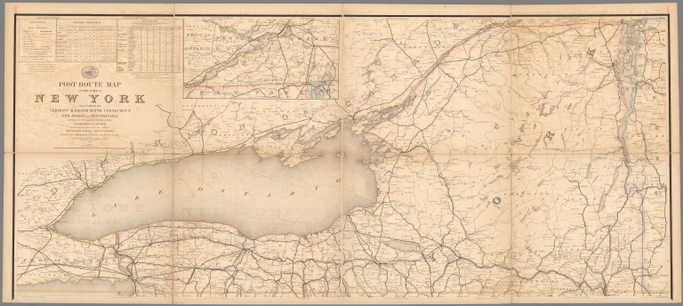
Author
United States. Post Office Department
Full Title
Upper Part Post Route Map of the State of New York with Parts of Vermont, Massachusetts, Connecticut, New Jersey, and Pennsylvania. (inset) (Montreal and Vicinity.)
List No
10433.004
Note
Updated to 1879 from 1868. 8 panels. Has letter and list, List Nos. 9394.002 and 9394.003, mounted on the back.
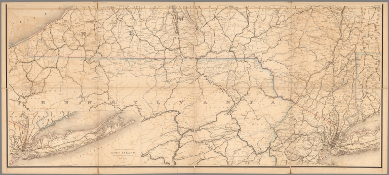
Author
United States. Post Office Department
Full Title
Lower Part Post Route Map of the State of New York with Parts of Vermont, Massachusetts, Connecticut, New Jersey, and Pennsylvania.
List No
10433.006
Note
Updated to 1879 from 1868. 8 panels.
Author
United States. Post Office Department
Full Title
(Composite Map) Post Route Map of the State of New York with Parts of Vermont, Massachusetts, Connecticut, New Jersey, and Pennsylvania.
List No
10433.007
Note
Updated to 1879 from 1868. 8 panels.
Author
United States. Post Office Department
Full Title
Post Route Map of the State of Maine and Adjacent Parts of New Hampshire and Dominion of Canada.
List No
10434.002
Note
Updated to 1879 from 1869. 4 panels.
Author
United States. Post Office Department
Full Title
New Hampshire, Vermont, Massachusetts, Rhode Island, Connecticut and Parts of New York and Maine.
List No
10435.002
Note
Updated to 1879 from 1866. 8 panels.
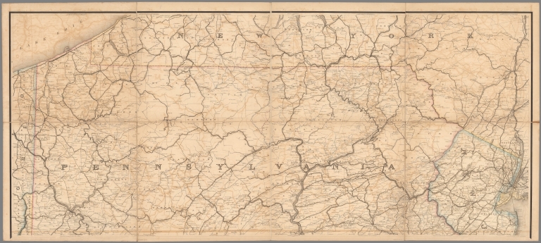
Author
United States. Post Office Department
Full Title
Upper Part Post Route Map of the States of Pennsylvania, New Jersey, Delaware, Maryland and of the District of Columbia.
List No
10436.002
Note
Updated to 1879 from 1869. 8 panels.
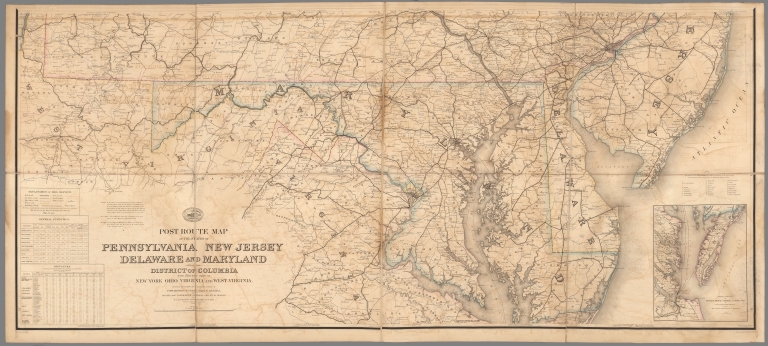
Author
United States. Post Office Department
Full Title
Lower Part Post Route Map of the States of Pennsylvania, New Jersey, Delaware, Maryland and of the District of Columbia.
List No
10436.004
Note
Updated to 1879 from 1869. 8 panels.
Author
United States. Post Office Department
Full Title
(Composite Map) Post Route Map of the States of Pennsylvania, New Jersey, Delaware, Maryland and of the District of Columbia.
List No
10436.005
Note
Updated to 1879 from 1869. 8 panels.
Author
United States. Post Office Department
Full Title
Post Route Map of Ohio and Indiana with Adjacent Parts of Pennsylvania, Michigan, Illinois, Kentucky and West Virginia.
List No
10437.002
Note
Updated to 1879 from 1870. 12 panels.
Author
United States. Post Office Department
Full Title
Post Route Map of States of Michigan and Wisconsin with Adjacent Parts of Ohio, Indiana, Illinois, Iowa and Minnesota.
List No
10438.002
Note
Updated to 1879 from 1871. 12 panels.
Author
United States. Post Office Department
Full Title
Upper Part. Post Route Map of States of Illinois, Iowa and Missouri with Adjacent Parts of Indiana, Wisconsin, Minnesota, Nebraska, Kansas, and Arkansas.
List No
10439.002
Note
Updated to 1879 from 1872. 8 panels.
Author
United States. Post Office Department
Full Title
Lower Part. Post Route Map of States of Illinois, Iowa and Missouri with Adjacent Parts of Indiana, Wisconsin, Minnesota, Nebraska, Kansas, and Arkansas.
List No
10439.004
Note
Updated to 1879 from 1872. 8 panels.
Author
United States. Post Office Department
Full Title
(Composite Map) Post Route Map of States of Illinois, Iowa and Missouri with Adjacent Parts of Indiana, Wisconsin, Minnesota, Nebraska, Kansas, and Arkansas.
List No
10439.005
Note
Updated to 1879 from 1872. 8 panels.
Author
United States. Post Office Department
Full Title
Post Route Map of State of Minnesota with Adjacent Parts of Iowa, Nebraska, Dakota, Wisconsin and of the British Possessions (Canada).
List No
10440.002
Note
Updated to 1879 from 1876. 12 panels.
Author
Union Pacific Railroad Company
Full Title
Western Vacationlands. Willmarth. Union Pacific Railroad. Printed in U.S.A. 2-1-46. Rand McNally, Chicago.
List No
11905.003
Note
Pictorial map on sheet 46 x 60, folded into pictorial self wrappers 23x10. Map signed by Willmarth, with Chicago and St. Louis to the east stretching to the west coast. The lines of the Union Pacific railroad are boldly delineated in red. Shows place names, landmarks, National parks, mining, farms,industry, and images highlighting the recreational activities and places of interest. Includes text: "In the region known as the Union Pacific West there awaits a world of adventure, pleasure, and spectacular scenic beauty." On verso: illustrations and text on California, the Pacific Northwest, scenic attractions en route to or from California, Yellowstone, Colorado, Dude ranches, Sun Valley, and Union Pacific Railroad offices.
Author
Nostrand, George J.
Full Title
Nostrand's map of New York house numbers and subway guide. Ohman Map Co. Copyright George J. Nostrand 258 Broadway, N.Y. (inset) Rapid Transit map of Greater New York. (cover title) Nostrand's map of New York City : contents: House - numbers, subways - elevated, Bus - street car & steamship lines, parks, piers, ferries, with inset subway & elevated map of Greater New York.
List No
11916.002
Note
1 map on 2 sheets, each 81x42, folded to 22x11. Shows subdivisions, house numbers, subways, elevated, bus, street car & steamship lines, parks, piers, ferries, points of interest, etc. Each sheet includes index. Date estimated.
Author
Nostrand, George J.
Full Title
Nostrand's map of New York house numbers and subway guide. Ohman Map Co. Copyright George J. Nostrand 258 Broadway, N.Y. (inset) Rapid Transit map of Greater New York. (cover title) Nostrand's map of New York City : contents: House - numbers, subways - elevated, Bus - street car & steamship lines, parks, piers, ferries, with inset subway & elevated map of Greater New York.
List No
11916.003
Note
1 map on 2 sheets, each 81x42, folded to 22x11. Shows subdivisions, house numbers, subways, elevated, bus, street car & steamship lines, parks, piers, ferries, points of interest, etc. Each sheet includes index. Date estimated.
Author
Nostrand, George J.
Full Title
(Composite) Nostrand's map of New York house numbers and subway guide. Ohman Map Co. Copyright George J. Nostrand 258 Broadway, N.Y. (inset) Rapid Transit map of Greater New York. (cover title) Nostrand's map of New York City : contents: House - numbers, subways - elevated, Bus - street car & steamship lines, parks, piers, ferries, with inset subway & elevated map of Greater New York.
List No
11916.004
Note
1 map on 2 sheets, each 81x42, folded to 22x11. Shows subdivisions, house numbers, subways, elevated, bus, street car & steamship lines, parks, piers, ferries, points of interest, etc. Each sheet includes index. Date estimated.
Author
W. & A.K. Johnston
Full Title
Johnstons' Plan of the siege of Sevastopol : showing the positions of the Allied & Russian Armies from the Admiarlty Surveys. April 1855. -- W. & A.K. Johnston. Edinburgh. Engravers & Geographer to the Queen. (to accompany) Johnstons' atlas of the war-1855. (inset) View of Sevastopol.
List No
8367.011
Note
Hand color map. Showing railways, fortified places, major cities, towns and villages, roads, churches, etc. Includes explanation and notes. Relief shown by hachures. Prime meridian is Greenwich.
Author
Bartholomew, J. G. (John George), 1860-1920
Full Title
India : General railway map. Plate 17. The Edinburgh Geographical Institute. Copyright John Bartholmew & Co. (to accompany) Constable's Hand Atlas of India : a new series of sixty maps and plans ... J. G. Batholomew ... Westminster : Archibald Constable & Company, MDCCCXCIII (1893).
List No
11794.022
Note
Color map of India, with inset of continuation map. Showing railway system, roads, administrative boundaries, major cities, towns and villages.
Author
Bartholomew, J. G. (John George), 1860-1920
Full Title
India : Railways, telegraphs, and navigable canals: Section I. Plate 18. The Edinburgh Geographical Institute. Copyright John Bartholmew & Co. (to accompany) Constable's Hand Atlas of India : a new series of sixty maps and plans ... J. G. Batholomew ... Westminster : Archibald Constable & Company, MDCCCXCIII (1893).
List No
11794.023
Note
Color map of Northwestern India. Showing railway system, navigable canals, steamer routes and telegraph cables. Includes legend.
Author
Bartholomew, J. G. (John George), 1860-1920
Full Title
India : Railways, telegraphs, and navigable canals: Section II. Plate 19. The Edinburgh Geographical Institute. Copyright John Bartholmew & Co. (to accompany) Constable's Hand Atlas of India : a new series of sixty maps and plans ... J. G. Batholomew ... Westminster : Archibald Constable & Company, MDCCCXCIII (1893).
List No
11794.024
Note
Color map of Northeastern India. Showing railway system, navigable canals, steamer routes and telegraph cables. Includes legend.
Author
Bartholomew, J. G. (John George), 1860-1920
Full Title
India : Railways, telegraphs, and navigable canals: Section III. Plate 20. The Edinburgh Geographical Institute. Copyright John Bartholmew & Co. (to accompany) Constable's Hand Atlas of India : a new series of sixty maps and plans ... J. G. Batholomew ... Westminster : Archibald Constable & Company, MDCCCXCIII (1893).
List No
11794.025
Note
Color map of the Southern India. Showing railway system, navigable canals, steamer routes and telegraph cables. Includes legend.
Author
[Canada. Department of Mines and Technical Surveys, Nicholson, N. L. (Norman Leon), Comtois, Paul]
Full Title
(Text Page to) (83) Railways : (Railways in Western Canada) -- (Railways in Eastern Canada). Compiled from information supplied by the Geographical Branch, (Canada) Department of Mines and Technical Surveys.
List No
14001.171
Note
Descriptive text on verso of (83) Railways: This plate shows the location of Canadian railways as of 1957 ...
Author
[Canada. Department of Mines and Technical Surveys, Nicholson, N. L. (Norman Leon), Comtois, Paul]
Full Title
(83) Railways : (Railways in Western Canada) -- (Railways in Eastern Canada). Compiled from information supplied by the Geographical Branch, (Canada) Department of Mines and Technical Surveys.
List No
14001.172
Note
2 maps showing railways in Canada. Each 23 x 64 cm. Includes key and legend. Features distance table: Railway mileage. With 3 insets: Railway in the Whitehorse vicinity (5 x 5 cm) -- Railway in the Churchill vicinity (7 x 5 cm) -- Railway in the Schefferville to the Sept-Iles vicinities (12 x 5 cm). Scale 1:5,000,000 or one inch to 78.91 miles. Lambert Conformal Conic Projection Standard Parallels 49˚N and 77˚N. Descriptive text on verso: This plate shows the location of Canadian railways as of 1957 ...
Author
[Canada. Department of Mines and Technical Surveys, Nicholson, N. L. (Norman Leon), Comtois, Paul]
Full Title
(Text Page to) (84) Railway freight traffic : (Railway freight traffic in Western Canada) -- (Railway freight traffic in Eastern Canada). Compiled from information supplied by the Geographical Branch, (Canada) Department of Mines and Technical Surveys.
List No
14001.173
Note
Descriptive text on verso of (84) Railway freight traffic: The data for this plate, which are for 1954, were supplied to the Geographical Branch by the railway companies ...
Author
[Canada. Department of Mines and Technical Surveys, Nicholson, N. L. (Norman Leon), Comtois, Paul]
Full Title
(84) Railway freight traffic : (Railway freight traffic in Western Canada) -- (Railway freight traffic in Eastern Canada). Compiled from information supplied by the Geographical Branch, (Canada) Department of Mines and Technical Surveys.
List No
14001.174
Note
2 maps showing railway freight traffic in Canada. Each 23 x 64 cm. Includes legend. With 3 insets: Railway freight traffic in the Whitehorse vicinity (5 x 5 cm) -- Railway freight traffic in the Churchill vicinity (7 x 7 cm) -- Railway freight traffic in the Schefferville to the Sept-Iles vicinities (13 x 5 cm). Scale 1:5,000,000 or one inch to 78.91 miles. Lambert Conformal Conic Projection Standard Parallels 49˚N and 77˚N. Descriptive text on verso: The data for this plate, which are for 1954, were supplied to the Geographical Branch by the railway companies ...
Author
Bartholomew, J.G.
Full Title
Plate 15. Scotland Railways and Routes.
List No
12428.040
Author
Bartholomew, J.G.
Full Title
Plate 62. Environs of Edinburgh.
List No
12428.089
Author
Bartholomew, J.G.
Full Title
Plate 63. Plan of Edinburgh & Leith.
List No
12428.090
Note
Black and white.
Author
Bartholomew, J.G.
Full Title
Plate 64. Plan of Glasgow.
List No
12428.091
Author
Bartholomew, J.G.
Full Title
Plate 65. Plan of Greenock.
List No
12428.092
Author
Bartholomew, J.G.
Full Title
Plate 66. Plan of Dundee.
List No
12428.093
Author
Bartholomew, J.G.
Full Title
Plate 67. Plan of Aberdeen.
List No
12428.094
Author
Bartholomew, J.G.
Full Title
Plate 68. Oban. Inverness. St. Andrews. Perth. Stirling. Peebles.
List No
12428.095
Note
Six city maps on one sheet.
Author
[Griffith, Richard John,; Sir; (1784-1878), Ireland, Railway Commissioners]
Full Title
(Covers to) A General Map Of Ireland to Accompany the Report of the Railway Commissioners shewing the Principal Physical Features and Geological Structure Of The Country. Constructed In 1836 And Engraved In 1837-8. The Geology Revised And Improved In 1855. Published And Sold By Hodges & Smith, Dublin, And Longman & Co., London. With whom Copies coloured Geologically are deposited. Price Twenty Shillings Plain ...
List No
0337.001
Note
1st ed. was 1836/7; Signed by Griffith & Larcom (perhaps printed signatures). Not colored Geologically, but politically with the Railroads. Originally published to accompany the Atlas to accompany the second Report of the Railway Commissioners, 1837. Map is in four sheets, each dissected into 20 sections. Full color. Sheets have marbled end papers and fold into a black leather covered slip case 25x18 with "Map Of Ireland. Stanford" stamped in gilt on the spine.
Author
[Griffith, Richard John,; Sir; (1784-1878), Ireland, Railway Commissioners]
Full Title
(North West Sheet) A General Map Of Ireland to Accompany the Report of the Railway Commissioners shewing the Principal Physical Features and Geological Structure Of The Country. Constructed In 1836 And Engraved In 1837-8. The Geology Revised And Improved In 1855. Published And Sold By Hodges & Smith, Dublin, And Longman & Co., London. With whom Copies coloured Geologically are deposited. Price Twenty Shillings Plain ...
List No
0337.002
Note
1st ed. was 1836/7; Signed by Griffith & Larcom (perhaps printed signatures). Not colored Geologically, but politically with the Railroads. Originally published to accompany the Atlas to accompany the second Report of the Railway Commissioners, 1837. Map is in four sheets, each dissected into 20 sections. Full color. Sheets have marbled end papers and fold into a black leather covered slip case 25x18 with "Map Of Ireland. Stanford" stamped in gilt on the spine.
Author
[Griffith, Richard John,; Sir; (1784-1878), Ireland, Railway Commissioners]
Full Title
(North East Sheet) A General Map Of Ireland to Accompany the Report of the Railway Commissioners shewing the Principal Physical Features and Geological Structure Of The Country. Constructed In 1836 And Engraved In 1837-8. The Geology Revised And Improved In 1855. Published And Sold By Hodges & Smith, Dublin, And Longman & Co., London. With whom Copies coloured Geologically are deposited. Price Twenty Shillings Plain ...
List No
0337.003
Note
1st ed. was 1836/7; Signed by Griffith & Larcom (perhaps printed signatures). Not colored Geologically, but politically with the Railroads. Originally published to accompany the Atlas to accompany the second Report of the Railway Commissioners, 1837. Map is in four sheets, each dissected into 20 sections. Full color. Sheets have marbled end papers and fold into a black leather covered slip case 25x18 with "Map Of Ireland. Stanford" stamped in gilt on the spine.
Author
[Griffith, Richard John,; Sir; (1784-1878), Ireland, Railway Commissioners]
Full Title
(South West Sheet) A General Map Of Ireland to Accompany the Report of the Railway Commissioners shewing the Principal Physical Features and Geological Structure Of The Country. Constructed In 1836 And Engraved In 1837-8. The Geology Revised And Improved In 1855. Published And Sold By Hodges & Smith, Dublin, And Longman & Co., London. With whom Copies coloured Geologically are deposited. Price Twenty Shillings Plain ...
List No
0337.004
Note
1st ed. was 1836/7; Signed by Griffith & Larcom (perhaps printed signatures). Not colored Geologically, but politically with the Railroads. Originally published to accompany the Atlas to accompany the second Report of the Railway Commissioners, 1837. Map is in four sheets, each dissected into 20 sections. Full color. Sheets have marbled end papers and fold into a black leather covered slip case 25x18 with "Map Of Ireland. Stanford" stamped in gilt on the spine.
|