|
Author
[IRISH RAILWAY COMMISSION, LARCOM, Thomas Aiskew (1801 - 1879)]
Full Title
VI. Map of England and Ireland, Explanatory of that part of the Report of the Railway Commissioners, which relates to communication between London and Dublin, and other parts of Ireland. / Prepared & Engraved under the direction of Lieu.t Larcom Royal Eng.rs May 1837.
List No
15443.008
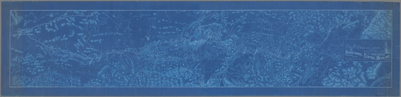
Author
FERROCARRIL CENTRAL MEXICANO COMPAÑIA LIMITADA
Full Title
Mapa del Ferrocarril Central Mexicano desde Paso del Norte pasando por los estados de Chihuahua, Durango, Coahuila, Zacatecas, Aguascalientes, Jalisco, Guanajuato y Queretaro hasta Mexico
List No
15439.000
Note
Date estimated.
Author
Knipe, James Alexander
Full Title
Geological & Mineralogical Map Of England And Wales, With Parts Of Scotland, Ireland & France, Showing also the Inland Navigation By means of Rivers & Canals, With their Elevation in feet above the Sea, The Rail Roads & Principal Roads, By J.A. Knipe ... T.W. Saunders, 6, Charing Cross) Published By J.A. Knipe, Jany. 1st 1847, and may be had of the Engraver, J. Dower, 6, Cumming Place, Pentonville, London. (Messrs. Grant & Griffith St. Pauls Ch. Yd. (late Harris). Designed and Drawn by J.A. Knipe. Engraved by I. Dower, Pentonville, London. (with 7 inset profiles).
List No
2051.002
Author
New Mexico State Corporation Commission
Full Title
Railroad Map Of The State Of New Mexico Prepared Under the Direction of State Corporation Commission 1913 ... Commissioners, Hugh H. Williams, Chairman, M.S. Groves, Commissioner, O.L. Owen, Commissioner. Santa Fe, N.M. (seal) State Corporation Commission Of New Mexico.
List No
4236.002
Author
Palmer, William. J.
Full Title
Map Of The Route Of The Southern Continental R.R. With Connections From Kansas City Mo. Ft. Smith Ark. And Shreveport La. Giving a general View of the Recent Surveys of the Kansas Pacific Railway Co, across the Continent Made in 1867 & 1868 under the direction of Gen. Wm. J. Palmer. On the routes of the 32nd and 35th Parallels. J.F Gedney Lith, Washington, D.C.
List No
3725.000
Note
Removed from Palmer's 1869 "Report of Surveys...for a route extending the Kansas Pacific Railway to the Pacific Ocean." Palmer used an exact copy Keeler's 1868 reduced scale edition of his National Map of the United States without credit in this first issue although Palmer's map adds much material along the line of the proposed southern continental route, especially in the Grand Canyon; in fact, this map is best known as the first map to use the name "Grand Canyon" of the Colorado. The Kansas Pacific had dreams of extending their line to California, as shown on this map, but it never happened. The map shows the routes of the Northern Pacific, the Union and Central Pacific, and the Southern Route. Ms color red and blue lines have been drawn on the various routes, adding an additional route from Centreville, Nevada, to Portland, Oregon (probably following Dodge's proposals - see his report). The main Kansas Pacific line has at least sixteen proposed branches! There is a later issue of this map that credits Keeler as a source (see our copy).
Author
Palmer, William. J.
Full Title
Map Of The Route Of The Southern Continental R.R. With Connections From Kansas City Mo. Ft. Smith Ark. And Shreveport La. Giving a general View of the Recent Surveys of the Kansas Pacific Railway Co, across the Continent Made in 1867 & 1968 under the direction of Gen. Wm. J. Palmer. On the routes of the 32nd and 35th Parallels together with compilations from Keeler's Official Map showing the Central and Northern Routes to the Pacific, and the intermediate topography. J.F Gedney Lith, Washington, D.C.
List No
4692.000
Note
This is a somewhat later issue of the Palmer map that adds a Keeler credit in the title, above the title adds the date June 1869 next to three railroad symbol explanations, and adds a table of "Distances by the Kansas Pacific Railway to Denver & Cheyenne thence by the Pacific Railroad to San Francisco," and eliminates the "explanations" in the lower right.
Author
Keeler, William J.
Full Title
National Map Of The Territory Of The United States From The Mississippi River To The Pacific Ocean. Made by the authority of the Hon. O.H. Browning Secretary of the Interior. In the Office of the Indian Bureau Chiefly For Government Purposes under the direction of the Hon. N.G. Taylor Commisr. of Indian affairs & Hon. Chas. E. Mix Chief Clerk of the Indian Bureau; Compiled from authorized explorations of Pacific Rail Road Routes, Public Surveys, and other reliable data from the Departments from the Government at Washington, D.C., by W.J. Keeler, Civil Engineer. 1867. N. DuBois Draughtsman. J.F. Gedney, Lithographer, Engraver & Plate Printer, Washington, D.C. Entered ... 1867 by Wm. J. Keeler ... District of Columbia.
List No
4737.002
Author
Keeler, William J.
Full Title
National Map Of The Territory Of The United States From The Mississippi River To The Pacific Ocean. Made by the authority of the Hon. O.H. Browning Secretary of the Interior. In the Office of the Indian Bureau Chiefly For Government Purposes under the direction of the Hon. N.G. Taylor Commisr. of Indian affairs & Hon. Chas. E. Mix Chief Clerk of the Indian Bureau; Compiled from authorized explorations of Pacific Rail Road Routes, Public Surveys, and other reliable data from the Departments from the Government at Washington, D.C., by W.J. Keeler, Civil Engineer. 1867. N. DuBois Draughtsman. J.F. Gedney, Lithographer, Engraver & Plate Printer, Washington, D.C. Entered ... 1867 by Wm. J. Keeler ... District of Columbia.
List No
0397.002
Author
Keeler, William J.
Full Title
National Map Of The Territory Of The United States From The Mississippi River To The Pacific Ocean. Made by the authority of the Hon. O.H. Browning Secretary of the Interior. In the Office of the Indian Bureau Chiefly For Government Purposes under the direction of the Hon. N.G. Taylor Commisr. of Indian affairs & Hon. Chas. E. Mix Chief Clerk of the Indian Bureau; Compiled from authorized explorations of Pacific Rail Road Routes, Public Surveys, and other reliable data from the Departments from the Government at Washington, D.C., by W.J. Keeler, Civil Engineer. 1867. N. DuBois Draughtsman. J.F. Gedney, Lithographer, Engraver & Plate Printer, Washington, D.C. Entered ... 1867 by Wm. J. Keeler ... District of Columbia.
List No
4694.002
Author
Keeler, William J.
Full Title
(Title page to) (Covers to) Notes To Accompany Keeler's Map of the U.S. Territory, From The Mississippi River To The Pacific Ocean, Containing Authentic Information Connected With The Territories, And The Different Railroad Routes To The Pacific Ocean.
List No
4695.001
Author
Keeler, William J.
Full Title
(Composite text to) Notes To Accompany Keeler's Map of the U.S. Territory, From The Mississippi River To The Pacific Ocean, Containing Authentic Information Connected With The Territories, And The Different Railroad Routes To The Pacific Ocean.
List No
4695.002
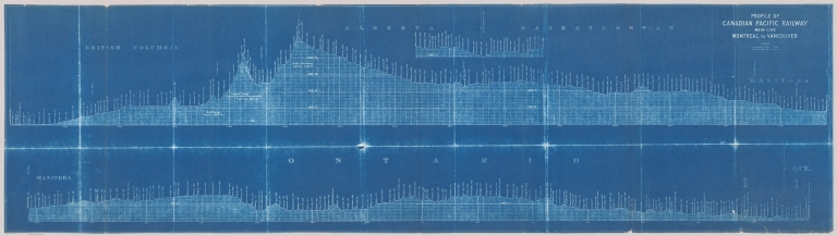
Author
Canadian Pacific Railway Company
Full Title
Profile of Canadian Pacific Railroad Main Line Montreal to Vancouver.
List No
15415.000
Note
Verticle scale is 1:12,000 Date estimated.
Author
Andriveau-Goujon, J.
Full Title
Carte Generale des Routes, Des Chemins De Fer et des principales Voies Navigables De L'Europe, Redigee d'apres les Itineraires les plus recents et des Documents fournis Par Le Ministere Des Travaux Publics. (Bureau central de Statistique.) Publiee Par J. Andriveau-Goujon, Rue du Bac, 21. Paris - 1866. Paris, Impie. de Chardon Jne. fils, Rue Racine, 3. Grave par P. Rousset.
List No
1500.002
Author
Bartholomew, John
Full Title
Bartholomew's Railway Map Of The British Isles. 1927 ... The Edinburgh Geographical Institute. Copyright - John Bartholomew & Son, Ltd. (inset) London And Suburbs. (inset) Channel Islands.
List No
1543.002
Author
[Tanner, Henry Schenck, 1786-1858, Melish, John]
Full Title
A Map of Philadelphia County Constructed by virtue of an Act of the Legislature of Pennsylvania
List No
15333.002
Note
The depiction of railroads around Philadelphia is very early and many lines are prospective.
Author
Lane, John J. (John Jenness), 1860-
Full Title
Trolley Wayfinder : Birds eye view of trolley routes in New England. Published by New England Street Railway Club. 12 Pearl St., Boston, Mass. 1908.
List No
14456.002
Note
Pocket railway map of New England. Front cover includes cover title and imprint. Map shows railways, roads, buildings, topography, vegetation, bodies of water and drainage. With seven inset maps: [Boston and vicinity] -- Portsmouth and Lewiston -- Springfield to Turners Falls -- Worcester to Springfield -- Springfield to New York City -- Pittsfield and vicinity -- Rochester to Nashua -- A triangle route. Map is 52 x 36 cm, on fold-out sheet 53 x 37 cm. With advertisement on verso of front cover, which faces map.
Author
Chicago, Rock Island, and Pacific Railway Company
Full Title
Rock Island Lines and connections : Route of Golden State Limited to California, Rocky Mountain Limited to Colorado. By Chicago, Rock Island & Pacific Railway Co. 1923.
List No
14460.002
Note
Pocket railway map of the Western United States. Shows political boundaries, cities, railways, roads, parks, bodies of water, drainage and coastlines. With inset map: [Florida]. Colored lithograph. Map is 43 x 79 cm, on sheet 46 x 82 cm.
Author
Canadian National Railways
Full Title
The Triangle Tour of British Columbia : Jasper National Park, Mount Robson Park, Canadian Rockies and the Scenic Seas of the North Pacific Cost. Canadian National Railways. Lithographed in Canada.
List No
14461.002
Note
Map of the Triangle Tour of British Columbia. Shows political boundaries, cities, railways, steamship lines, trails, parks, topography, bodies of water, drainage, coastlines and islands. Relief shown with shading. Includes a legend and descriptive text. With photographic views: Totem Poles, Kitwanga -- Scenic Seas, Pacific Coast -- The Fraser Canyon -- Mount Robson -- Jasper Park Lodge, Jasper National Park -- Roof of the World. Colored lithograph. Map is 43 x 76 cm, on sheet 44 x 77 cm.
Author
Canadian National Railways
Full Title
Alaska and the Yukon -- Routes of Canadian National Pacific Coast Services, Canadian National Steamship Company Ltd.
List No
14461.003
Note
Two maps of the Alaska and the Yukon, as well as the railway lines of the Canadian National Pacific Coast Services and the steamship lines of the Canadian National Steamship Company Ltd. Maps also show political boundaries, cities, parks, topography, bodies of water, drainage, coastlines and islands. Relief shown with shading. Includes descriptive text. Colored lithograph. Together, maps are 75 x 42 cm, on sheet 77 x 44 cm.
Author
[Confederazione generale dell'industria italiana, Associzaione fra le società italiane per azioni]
Full Title
Ferrovie : Tonnellate di merci trasportate sulla rete esercitata dallo stato.
List No
14403.086
Note
Chart showing the tons of goods transported along the Italian railway network, from 1906 to 1928. Includes descriptive text. Colored lithograph, on sheet 21 x 29 cm.
Author
[Pershing, John J. (John Joseph), 1860-1948, Geological Survey (U.S.)]
Full Title
Map of France superimposed on that of the United States : Showing relative distances and the extent of railroad systems used by the American Expeditionary Forces. House Doc. No. 626; 66th Cong., 2d Sess. Engraved and printed by the U. S. Geological Survey.
List No
14379.023
Note
Military map of France, overlaid upon the United States in order to show the relative distances between different cities. Features the railroad systems used by the American Expeditionary Forces during World War I. Shows political boundaries, cities, drainage, coastlines and islands. Includes a legend, explanatory notes and two bar scales given in kilometers and miles, as well as a compass rose with north oriented toward top of sheet (for the United States). Colored engraving. Map is 20 x 24 cm, on fold-out sheet 23 x 27 cm.
Author
[A. Ilyin Cartographic Establishment, Ilyin, A.]
Full Title
Karta parohodnih soobshshyeniy zhyelyeznih i pochtovih dorog Rossiyskoy Impyerii.S. Peterburgi 1894. Izdaniye kartografichyeskogo zavyedyeniya A. Ilyin. (with 10 insets).
List No
15265.000
Note
Outline color lithograph map of steamship communications, railways and postal network in the Russian Empire, dissected into 32 pieces, folded into sections 16x21, mounted mounted on linen. With 10 insets including: Karta Zakaspiyskoy zhyelyeznoy dorogi; karta sibirski zhyelyeznoy dorogi. Shows administrative divisions, cities and towns, rivers, railways, etc. Compare to the 1896 edition which shows many increases in the railroads (see our 8295.000)
Author
Realty-Bonds and Finance Co.
Full Title
Map Of Oakland, And Vicinity, Alameda, Berkeley, And Piedmont. Published By Realty-Bonds And Finance Co. 404 14th St. At Franklin St. Oakland, California. 1912-13. J. Watson Olver, Leonard H. Thomas, Draughtsmen, Room 82, 612 Broadway. Copyright 1912 By Realty-Bonds And Finance Co. Inc. Schmidt Lithograph Co. S.F.
List No
3676.002
Author
U.S. Coast Survey
Full Title
Southern Mississippi And Alabama Showing the Approaches To Mobile. Edw. Molitor Lith. Coast Survey Office, A.D. Bache Supt. 1863.
List No
5533.002
Author
Great Northern Railway
Full Title
Glacier National Park aeroplane map.
List No
15236.001
Note
Date estimated.
Author
Great Northern Railway
Full Title
Glacier National Park aeroplane map.
List No
15236.002
Note
Date estimated.
Author
Great Northern Railway
Full Title
Glacier National Park aeroplane map.
List No
15236.003
Note
Date estimated.
Author
Missouri, Kansas & Texas Railway
Full Title
OKLAHOMA, THE NEW STATE. - Sectional Map Of Oklahoma Traversed By The Missouri, Kansas & Texas Railway- Showing the crops adapted to each section with the elevation and annual rainfall...,
List No
15228.000
Note
Date estimated.
Author
Mektepler Uqün
Full Title
جۇڭگونىك رايونلرى قاتنشى = Traffic in Chinese regions. (to accompany) جۇڭگو ئاتلسى = Jongu atlasi = Atlas of China. Ottura : Mektepler Uqün. Hormetler Neshriyâti. 1sr. edition, June 1984.
List No
13683.004
Note
Traffic map of China. With insets: airways map of China, location map and table. Showing administrative boundaries, roads, railroads and water ways.
Author
Survey of India
Full Title
India showing Railways open and under construction on 31-3-15. Published under the direction of Colonel Sir S.G. Burrad ... Survey General of India. 1915. Heliozincographed at the Survey of India Office, Calcutta.
List No
13442.000
Author
Oklahoma Corporation Commission
Full Title
Railroad Map Of Oklahoma Published By The State. Prepared Under The Direction Of Corporation Commission Of Oklahoma 1909. Commissioners J.E. Love, Chairman, J.J. McAlester, Commissioner, A.P. Watson, Commissioner. Copyright 1909, by J.E. Love, Chairman of Corporation Commission for the State of Oklahoma. Compiled and Drawn by The Engineering Department Corporation Commission. Woodward & Tiernan Printing Co. Map Engravers, St. Louis, Mo. H.H.B. 3-1. 09. (seal) Great Seal Of The State Of Oklahoma 1907.
List No
4294.002
Author
[(Montana) Railroad Commission, Rand McNally and Company.]
Full Title
Railroad Commission Map Of Montana 1908. Commissioners: B.T. Stanton, Nathan Godfrey, E.A. Morley, H.K. Howry, Secretary. Rand, McNally & Co. Engravers, Chicago. Copyright, 1908, by Rand McNally & Co.
List No
4343.002
Author
Southern Pacific Railroad
Full Title
Map of California National Education Association Edition. Illustrating Its Climatolgy, Comparative Area, Reil Lines, Topography, Etc.
List No
15134.002
Author
[Portugal. Ministério das Colónias, Portugal. Junta de Investigações Coloniais]
Full Title
Carta das linhas férreas e aéreas de Angola e Moçambique e suas principais ligações com as colónias limítrofes. Gravada e impressa no Instituto Geographico e Cadastral, em 1945. Ministério das Colónias, Junta das Missões Geográficas e de Investigações Coloniais, Outubro de 1940.
List No
14369.020
Note
Map of southern Africa, featuring railways and air lines of Angola and Mozambique, with their main connections to the neighboring nations. Also shows political boundaries, cities, bodies of water, drainage, coastlines and islands. Includes latitudinal and longitudinal lines, as well as a legend and bar scale. Colored lithograph. Map is 36 x 52 cm, on double sheet 48 x 69 cm.
Author
Spinner, Walther
Full Title
Simplon Orient-Express, la voie internationale la plus directe et la plus pittoresque
List No
15071.000
Note
Edition: Commission Romande de la Ligne du Simplon Lausanner (Gd-Pont 2 1947
Author
[Suomen Maantieteellinen Seura, Tilgmann, Ferdinand, 1832-1911]
Full Title
No. 28. Henkilöitten ja Tavaratonnien lukumäärä kuljetettu Valtiorautateitten asemain välisillä matkoila vuonna 1895. = Antal personer och Tontal gods som transporterats på hvarje sträcka emellan stationerna å Statsjernvägarne under år 1895.
List No
14366.040
Note
Two statistical charts of Finland. Charts feature the number of persons and tons of goods transported on the State Railways in 1895. Charts include legends, as well as a bar scale. Charts indexed. Colored lithograph. Together, charts are 50 x 35 cm, on double sheet 60 x 43 cm. Text presented in parallel Finnish and Swedish.
Author
[Geographia Map Co., Pennsylvania Railroad]
Full Title
The Complete Map of New York (Manhattan) Featuring House Numbers, Transit Lines, Playgrounds, Wading Pools, etc.
List No
15000.000
Author
شكوفه مقبل [Şukufe Mukbil]
Full Title
(European Russia with railroads)
List No
10992.009
Note
Dimensions are sheet size.
Author
شكوفه مقبل [Şukufe Mukbil]
Full Title
(Great Britain and Ireland)
List No
10992.013
Note
Dimensions are sheet size.
Author
شكوفه مقبل [Şukufe Mukbil]
Full Title
(Italy with railroads)
List No
10992.014
Note
Dimensions are sheet size.
Author
شكوفه مقبل [Şukufe Mukbil]
Full Title
(The Caucasus with railroads)
List No
10992.021
Note
Dimensions are sheet size.
Author
Hudson & Manhattan Rail Road
Full Title
[New York Baseball Schedule Map 1952] Take the Tube
List No
10950.001
Author
Mols-Marchal, L
Full Title
Nouvelle Carte generale des Chemins de Fer de la Belgique, indiquant Les Lignes Exploites en Construction & Concedees, Ainsi Que les distances de la Capital aux differentes stations
List No
10926.002
Author
Amerine & Wilson
Full Title
Amerine & Wilson's indexed township & county map of California. Compiled and published by Amerine and Wilson, Map Publishers and Mounters, 815 Montgomery St., San Francisco Cal, 1892. Copyrighted by Amerine & Wilson 1892. Photo. lith. Britton & Rey, S.F.
List No
14267.002
Note
Colored photo-lithographed map of California with townships and counties, as of 1892. Shows political boundaries, topography, lakes, drainage, marshlands, coastline, islands, ports, cities and towns, railroads (completed, under construction and proposed), wagon roads, trails and "Indian Reservations", such as "Mission" in the San Jacinto Mountains and "Round Valley" near Mendocino. Relief shown with hachures. Eastern part of San Bernadino and San Diego Counties depicted on right of sheet. Includes a legend and a bar scale. Additional explanation appears on verso of front cover. Indexed to indicate towns, counties, post offices, and population according to the latest census. Lake Tahoe also labeled Bigler. Map is 86 x 65 cm, on sheet 92 x 70 cm.
Author
[Commercial Club of Chicago. Civic Committee, Burnham, Daniel Hudson, 1846-1912, Bennett, Edward H. (Edward Herbert), 1874-1954, Moore, Charles]
Full Title
LXXIII. Chicago : Diagram of the city and surrounding country, showing railroad circuits, B, C, D and E, which are, or may become, tangent to the inner circuit (A).
List No
14346.059
Note
Map of Chicago within fifth chapter to Plan of Chicago. Shows railroads, roads, topography, lakes, drainage, shoreline and harbor. Relief shown with contour lines. With descriptive text: The diagram also shows the existing industries, and the probable trend of growth away from the center of the city. Includes a legend. Indexed, with key on facing page of descriptive text (66). Colored lithograph. Map is 21 x 17 cm, on sheet 31 x 24 cm. (Page number inferred.) Chapter spans pages 61-78.
Author
[Commercial Club of Chicago. Civic Committee, Burnham, Daniel Hudson, 1846-1912, Bennett, Edward H. (Edward Herbert), 1874-1954, Moore, Charles]
Full Title
LXXIV. Chicago : Diagram of the city center, showing the general location of existing freight yards and railroad lines, the present tunnel system and proposed circuit, and connections for all these services, running to the central clearing yards.
List No
14346.061
Note
Map of Chicago within fifth chapter to Plan of Chicago. Shows railroads, roads, shoreline and harbor. Includes a legend and bar scale. Colored lithograph. Map is 18 x 19 cm, on sheet 31 x 24 cm. (Page number inferred.) Chapter spans pages 61-78.
Author
[Commercial Club of Chicago. Civic Committee, Burnham, Daniel Hudson, 1846-1912, Bennett, Edward H. (Edward Herbert), 1874-1954, Moore, Charles]
Full Title
CXI. Chicago : Plan of the center of the city, showing the present street and boulevard system.
List No
14346.087
Note
Map of Chicago within seventh chapter to Plan of Chicago. Shows roads, railway stations, bridges, parks, drainage, shoreline and harbor. Includes a legend and bar scale. With descriptive text: The proposed additional arteries and street widenings (orange) ... Colored lithograph. Map is 22 x 18 cm, on sheet 31 x 24 cm. Chapter spans pages 99-118.
Author
[Commercial Club of Chicago. Civic Committee, Burnham, Daniel Hudson, 1846-1912, Bennett, Edward H. (Edward Herbert), 1874-1954, Moore, Charles, Guérin, Jules Vallée, 1866-1946]
Full Title
CXII. Chicago : Proposed boulevard to connect the north and south sides of the river; view looking north from Washington Street / painted for the Commercial Club by Jules Guerin.
List No
14346.088
Note
Bird's-eye view of Chicago within seventh chapter to Plan of Chicago. Shows buildings, roads, vegetation, fountain, horse-drawn buggies and figures. With descriptive text: The boulevard is raised to allow free flow of east-and-west teaming traffic under it, and both Michigan Avenue and Beaubien Court are raised to the boulevard level ... Colored lithograph. View is 23 x 18 cm, on sheet 31 x 24 cm. Chapter spans pages 99-118.
Author
[Commercial Club of Chicago. Civic Committee, Burnham, Daniel Hudson, 1846-1912, Bennett, Edward H. (Edward Herbert), 1874-1954, Moore, Charles, Guérin, Jules Vallée, 1866-1946]
Full Title
CXXI. Chicago : Proposed Twelfth Street boulevard at its intersections with Michigan Avenue and Ashland Avenue / painted for the Commercial Club by Jules Guerin.
List No
14346.094
Note
Bird's-eye view of Chicago within seventh chapter to Plan of Chicago. Shows a proposed railway terminal, as well as buildings, roads, bridges, parks, fountains and the Chicago River. With descriptive text: The proposed railway terminals are shown fronting on the Boulevard at its level, which is raised to allow north-and-south traffic to flow underneath ... Colored lithograph. View is 22 x 38 cm, on double sheet 31 x 48 cm. Chapter spans pages 99-118.
Author
[Commercial Club of Chicago. Civic Committee, Burnham, Daniel Hudson, 1846-1912, Bennett, Edward H. (Edward Herbert), 1874-1954, Moore, Charles, Guérin, Jules Vallée, 1866-1946]
Full Title
CXXII. Chicago : Railway station scheme west of the River between Canal and Clinton Streets, showing the relation with the Civic Center / painted for the Commercial Club by Jules Guerin.
List No
14346.095
Note
Bird's-eye view of Chicago within seventh chapter to Plan of Chicago. Shows a proposed railway and stations, as well as buildings, roads, bridges, parks, fountains and the Chicago River. With descriptive text: This plan provides for the railways at a level below that of the street, with the stations above. Colored lithograph. View is 17 x 36 cm, on double sheet 31 x 48 cm. Chapter spans pages 99-118.
Author
[Commercial Club of Chicago. Civic Committee, Burnham, Daniel Hudson, 1846-1912, Bennett, Edward H. (Edward Herbert), 1874-1954, Moore, Charles]
Full Title
CXXIX. Chicago : The business center of the city, within the First Circuit Boulevard, showing the proposed grand east-and-west axis and its relation to Grant Park and the yacht harbor; the railway terminals schemes on the south and west sides, and the Civic Center.
List No
14346.104
Note
Map of Chicago within seventh chapter to Plan of Chicago. Shows the city's business center with proposed roads, as well as park, harbor and railway terminals. Black and white lithograph. Map is 42 x 22 cm, on double sheet 48 x 31 cm. Chapter spans pages 99-118.
Author
[Koch, Wilhelm, Opitz, C.]
Full Title
(Index Page to) Ubersichtsplan zu Dr. W.Koch und C. Opitz : Eisenbahn und verkehrs - Atlas vom Deutschen Reich. 1. Erklarungen. Eisenbahn und verkehrsatlas von Europa. Section 1. Deustches Reich.
List No
13679.009
Note
Index map and title page of railway and traffic of the German Empire. Includes list of inset maps.
Author
[Koch, Wilhelm, Opitz, C.]
Full Title
Reich, Section 1. Eisenbahn und verkehrsatlas von Europa. Section 1. Erklärungen für Deutschland. Deutsches
List No
13679.010
Note
Text and map of Germany. Includes index to the railways, lists of abbreviations, transportation, map symbols and text. Includes inset map of Helgoland Island in North Sea, Prime meridian: Greenwich.
Author
[Koch, Wilhelm, Opitz, C.]
Full Title
Deutsches Reich. Section 2. Eisenbahn und verkehrsatlas von Europa. Section 2.
List No
13679.011
Note
Railways and traffic map of Germany. Prime meridian: Greenwich. Shows boundaries and Prussian states. Includes list of private railways.
Author
[Koch, Wilhelm, Opitz, C.]
Full Title
Deutsches Reich. Section 3. Eisenbahn und verkehrsatlas von Europa. Section 3.
List No
13679.012
Note
Railways and traffic map of Germany. Prime meridian: Greenwich. Shows boundaries. Includes list of German states and private railways, Danish, and Swedish private railways.
Author
[Koch, Wilhelm, Opitz, C.]
Full Title
Deutsches Reich. Section 4. Eisenbahn und verkehrsatlas von Europa. Section 4.
List No
13679.013
Note
Railways and traffic map of Germany. Prime meridian: Greenwich. Shows boundaries and Prussian states. Includes list of states and private railways.
Author
[Koch, Wilhelm, Opitz, C.]
Full Title
Deutsches Reich. Section 5. Eisenbahn und verkehrsatlas von Europa. Section 5.
List No
13679.014
Note
Railways and traffic folded map of Germany, with inset map. Prime meridian: Greenwich. Shows boundaries and Prussian states. Includes list of states and private railways, and Russian railways.
Author
[Koch, Wilhelm, Opitz, C.]
Full Title
Deutsches Reich. Section 6. Eisenbahn und verkehrsatlas von Europa. Section 6.
List No
13679.015
Note
Railways and traffic map of Germany, with inset map. Prime meridian: Greenwich. Shows boundaries. Includes list of German states and private railways and Dutch railways.
Author
[Koch, Wilhelm, Opitz, C.]
Full Title
Deutsches Reich. Section 7. Eisenbahn und verkehrsatlas von Europa. Section 7.
List No
13679.016
Note
Railways and traffic map of Germany. Prime meridian: Greenwich. Shows boundaries. Includes list of German states and private railways.
Author
[Koch, Wilhelm, Opitz, C.]
Full Title
Deutsches Reich. Section 8. Eisenbahn und verkehrsatlas von Europa. Section 8.
List No
13679.017
Note
Railways and traffic map of Germany. Prime meridian: Greenwich. Shows boundaries. Includes list of German states and private railways.
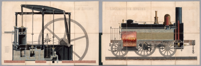
Author
Emslie, John, 1813-1875
Full Title
Double action condensing steam engine. Drawn & engraved by John Emslie, 10 Grays Inn Terrace, London. Published Sept. 15th. 1848 by James Reynolds, 174 Strand, London.
List No
14330.002
Note
View of a steam engine. Shows mechanical engineering, with arrows showing the direction of force. Descriptive text throughout, labeling different components. In addition, indexed to indicate other parts, with explanation at lower left corner. Hand-colored engraving. View is 55 x 82 cm, on dissected sheet, mounted on linen, 57 x 88 cm, folded to 29 x 22 cm. Followed by booklet of descriptive text, as well as a view of a locomotive engine, all housed together within a portfolio.
Author
Emslie, John, 1813-1875
Full Title
Locomotive engine. Drawn & engraved by John Emslie, 10 Grays Inn Terrace, London. Published Sept. 25th. 1848 by James Reynolds, 174 Strand, London.
List No
14330.012
Note
View of a locomotive engine. Shows mechanical engineering, with arrows showing the direction of force. Descriptive text throughout, labeling different components, including the fiery heart of the engine. Includes a legend and bar scale. Hand-colored engraving. View is 53 x 83 cm, on dissected sheet, mounted on linen, 58 x 88 cm, folded to 29 x 22 cm. Preceded by booklet of descriptive text, as well as a view of a steam engine, all housed together within a portfolio.
Author
Emslie, John, 1813-1875
Full Title
(Composite View to) Double action condensing steam engine. Drawn & engraved by John Emslie, 10 Grays Inn Terrace, London. Published Sept. 15th. 1848 by James Reynolds, 174 Strand, London. -- Locomotive engine. Drawn & engraved by John Emslie, 10 Grays Inn Terrace, London. Published Sept. 25th. 1848 by James Reynolds, 174 Strand, London.
List No
14330.013
Note
Composite view of both a steam engine and locomotive engine. Views show mechanical engineering, with arrows showing the direction of force. Descriptive text throughout, labeling different components. Hand-colored engravings. Together, views are 55 x 173 cm, on dissected sheets, mounted on linen, 58 x 178 cm. Accompanied by booklet of descriptive text, all housed together within a portfolio.
Author
[Canet Alvarez, Gerardo A., 1911-, Raisz, Erwin, 1893-1968, Harvard University. Institute of Geographical Exploration, Cuba. Ministerio de Agricultura]
Full Title
Patron de vida.
List No
14350.019
Note
Map showing the human geography of Cuba. Title translates to: Life patterns Features roads, railways, population and water consumption in the country. Includes a bar scale. With views comparing urban and rural communities. With charts depicting the economy, tracing changes in the twentieth century. Accompanied by descriptive text, which appears in Spanish, with English translations.
Author
Heather, William, 1764-1812
Full Title
No.11. The road of Salo. By Ayrouard. No. 12. The Port of Barcelona. By Michelot. No. 15. The Bay of Roses. By Michelot. No. 16. Cadaquie. By Ayrouard. J. Stephenson, Sc. (to accompany) The new Mediterranean Harbour pilot. By William Heather ... London : Printed for and published by J.W. Norie and Co., 1814.
List No
13404.011
Note
4 engraved nautical charts of Western Mediterranean on 1 plate. each 15x19. Including: Chart Nos. 11-12, 15-16.
Author
Aspioti-ELKA (Firm)
Full Title
KATAΣTPOΦEΣ ΣIΔHPOΔPOMIKΩN ΓEΦYPΩN, ΣHPAΓΓΩN KAI AΛΛΩN EΓKATAΣTAΣEΩN.
List No
14295.077
Note
Colored diagram representing Greece, showing the destruction of railroad bridges and tunnels during World War II, inflicted by Axis Powers. Accompanied by descriptive text on facing page in Greek, French, English and Russian, entitled, Destruction of railway bridges, tunnels, etc. Description: The balance sheet of destruction is tragic. Of all bridges and tunnels only a small percentage remains intact. Diagram is 39 x 31 cm, on sheet 47 x 35 cm. (Plate number 33, according to descriptive text.) Within the fourth section of the atlas, The destruction of public works.
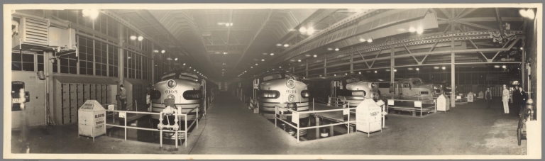
Author
Southern Pacific Lines
Full Title
(Untitled Panoramic Photograph of Southern Pacific trains at platform.)
List No
10803.000
Note
Date estimated.
Author
Rand, McNally & Co.
Full Title
How the Public Domain Has Been Squandered : Map showing the 139,403,026 acres of the peoples land - equal to 871,268 Farms of 160 Acres Each Worth at $2 an acre, $278,806,052, Given By Republican Congresses to Railroad Corporations. This is more land than is contained in New York, New Jersey, Pennsylvania, Ohio, and Indiana.
List No
13665.000
Note
Political broadside map of the United States, 30x40 on sheet 59x42. setting forth the Democratic Party Platform of 1884 and illustrating "Land Grants to Railroads and Wagon Roadsap
Author
Geographia Limited
Full Title
Great Western Railway
List No
10787.000
Note
Date estimated.
Author
[British Railways. Western Region, Bowyer]
Full Title
Somerset.
List No
10788.000
Note
Date estimated.
Author
[British Railways. Western Region, Bowyer]
Full Title
Devon.
List No
10789.000
Note
Date estimated.
Author
[Spencer, E.H., British Railways]
Full Title
Pictorial Map of Yorkshire by British Railways.
List No
10782.000
Author
Cram, George Franklin, 1841-1928
Full Title
Railroad and county map of Ohio. Geo. F. Cram, engraver and publisher, Chicago. 1882.
List No
14250.007
Note
Map of Ohio, showing railroads (both finished and unfinished), county boundaries, cities and towns, post offices, drainage and coastline. Political boundary lines in color. Includes a legend and a bar scale. With index numbers along the perimeter, and decorative border. 43 x 57 cm, on sheet 45 x 58.
Author
Cram, George Franklin, 1841-1928
Full Title
Michigan. Geo. F. Cram, engraver and publisher, 262 and 264 Wabash Avenue, Chicago, Ill. 1882.
List No
14250.011
Note
Map of Michigan, showing railroads (both finished and unfinished), county boundaries, cities and towns, drainage and coastline, as well as ports and water distances across Lake Michigan. Political boundary lines in color. Includes a legend and a bar scale. Each of the Great Lakes pictured - Michigan, Superior and Huron - lists metrics for greatest length, breadth, depth, and height above sea. With index numbers along the perimeter, and decorative border. Also, with two inset maps: Isle Royale -- Dominion of Canada. 55 x 40 cm, on sheet 58 x 45 cm.
Author
Cram, George Franklin, 1841-1928
Full Title
Indiana. Geo. F. Cram, engraver and publisher, 262 and 264 Wabash Avenue, Chicago, Ill. 1882.
List No
14250.014
Note
Map of Michigan, showing railroads (both finished and unfinished), county boundaries, cities and towns, drainage and coastline. Political boundary lines in color. With index numbers along the perimeter, and decorative border. 55 x 40 cm, on sheet 58 x 45 cm.
Author
Cram, George Franklin, 1841-1928
Full Title
Illinois. Geo. F. Cram, engraver and publisher, 262 and 264 Wabash Avenue, Chicago, Ill. 1882.
List No
14250.018
Note
Map of Illinois, showing railroads (both finished and unfinished), county boundaries, cities and towns, drainage and coastline. Political boundary lines in color. With index numbers along the perimeter, and decorative border. Also, with inset map: [Chicago and vicinity]. 55 x 40 cm, on sheet 58 x 45 cm.
Author
Cram, George Franklin, 1841-1928
Full Title
New railroad and county map of Iowa : Showing latest government surveys. Published by Geo. F. Cram, 262-264 Wabash Ave. Chicago. 1882.
List No
14250.020
Note
Map of Iowa, showing railroads (both proposed and existing), county boundaries, cities and towns, and drainage. Political boundary lines in color. Includes a legend and a bar scale. With index numbers along the perimeter, and decorative border. 37 x 50 cm, on sheet 45 x 58.
Author
Cram, George Franklin, 1841-1928
Full Title
New railroad and county map of Missouri : Showing latest government surveys. Published by Geo. F. Cram, 262-264 Wabash Ave. Chicago. 1882.
List No
14250.022
Note
Map of Missouri, showing railroads (both proposed and existing), county boundaries, cities and towns, and drainage. Political boundary lines in color. Includes a legend and a bar scale. With index numbers along the perimeter, and decorative border. Also, with two inset maps: The south-eastern extension of Missouri -- [St. Louis and vicinity]. 42 x 52 cm, on sheet 45 x 58.
Author
Cram, George Franklin, 1841-1928
Full Title
Cram's railroad and township map of Kansas. Published by Geo. F. Cram, proprietor of the Western Map Depot. 262-264 Wabash Ave. Chicago Ills. 1882.
List No
14250.024
Note
Map of Kansas, showing railroads, county boundaries, cities and towns, and drainage. Political boundary lines in color. Features territories of indigenous peoples, such as the Cheyenne, Osage and Cherokee. Includes a bar scale and a scale statement: Scale 19 miles to an inch. With index numbers along the perimeter, and decorative border. 39 x 53 cm, on sheet 45 x 58.
Author
Cram, George Franklin, 1841-1928
Full Title
Cram's railroad and township map of Nebraska. Published by Geo. F. Cram. 262-264 Wabash Ave. Chicago, Ills. 1882.
List No
14250.026
Note
Map of Nebraska, showing railroads, county boundaries, cities and towns, and drainage. Political boundary lines in color. Features territories of indigenous peoples, such as the Cheyenne and Sioux. Includes a bar scale and a scale statement: Scale 19 miles to an inch. With index numbers along the perimeter, and decorative border. 40 x 52 cm, on sheet 45 x 58.
Author
Cram, George Franklin, 1841-1928
Full Title
Cram's railroad and township map of Colorado. Published by Geo. F. Cram. 262-264 Wabash Ave. Chicago, Ills. 1882.
List No
14250.028
Note
Map of Colorado, showing railroads, county boundaries, cities and towns, and drainage. Political boundary lines in color. With index numbers along the perimeter, and decorative border. Also, with hand-drawn annotations tracing routes of travel, both along railroads and across landscapes where no official transit appears. 40 x 52 cm, on sheet 45 x 58.
Author
Cram, George Franklin, 1841-1928
Full Title
Wisconsin. Geo. F. Cram, engraver and publisher, 262 and 264 Wabash Avenue, Chicago, Ill. 1882.
List No
14250.032
Note
Map of Wisconsin, showing railroads (both finished and unfinished), county boundaries, cities and towns, post offices, drainage and coastline. Political boundary lines in color. Both of the Great Lakes pictured - Superior and Michigan - list metrics for greatest length, breadth, depth, and height above sea. Includes a legend and a bar scale. With index numbers along the perimeter, and decorative border. 55 x 40 cm, on sheet 58 x 45 cm.
Author
Cram, George Franklin, 1841-1928
Full Title
Minnesota. Geo. F. Cram, engraver and publisher, 262 and 264 Wabash Avenue, Chicago Ill.
List No
14250.034
Note
Map of Minnesota, showing railroads (both finished and unfinished), county boundaries, cities and towns, post offices, drainage and coastline. Political boundary lines in color. Features Indian reservations. Lake Superior lists metrics for greatest length, breadth, depth, and height above sea. Includes a legend and a bar scale. With index numbers along the perimeter, and decorative border. Also, with inset map: [Cook]. 55 x 40 cm, on sheet 58 x 45 cm.
Author
Cram, George Franklin, 1841-1928
Full Title
Railroad and county map of Dakota & Manitoba. Geo. F. Cram, engraver and publisher, Chicago.
List No
14250.036
Note
Map of the Dakotas and Manitoba (Canada), showing railroads (both finished and unfinished), county boundaries, cities and towns, post offices and drainage. Political boundary lines in color. Includes a legend. With index numbers along the perimeter, and decorative border. Also, with hand-drawn annotations tracing routes of travel across landscapes where no official transit appears. 55 x 40 cm, on sheet 58 x 45 cm.
Author
Cram, George Franklin, 1841-1928
Full Title
Railroad and county map of Kentucky and Tennessee. Geo. F. Cram, engraver and publisher, Chicago.
List No
14250.040
Note
Map of Kentucky and Tennessee, showing railroads (both finished and unfinished), county boundaries, cities and towns, and drainage. Political boundary lines in color. Includes a legend. With index numbers along the perimeter, and decorative border. Also, with hand-drawn annotations tracing routes of travel across landscapes where no official transit appears. 39 x 55 cm, on sheet 45 x 58 cm.
Author
Cram, George Franklin, 1841-1928
Full Title
Cram's railroad and county map of Georgia. Published by Geo. F. Cram, 262-264, Wabash, Ave. Chicago, Ills. 1882
List No
14250.042
Note
Map of Georgia, showing railroads, county boundaries, cities and towns, drainage and coastline. Political boundary lines in color. Includes a bar scale and a scale statement: Scale 19 miles to an inch. With index numbers along the perimeter, and decorative border. 47 x 37 cm, on sheet 58 x 45 cm.
Author
Cram, George Franklin, 1841-1928
Full Title
Cram's railroad and township map of Alabama. Published by Geo. F. Cram, proprietor of the Western Map Depot. 262-264, Wabash, Ave. Chicago Ills. 1882
List No
14250.044
Note
Map of Alabama, showing railroads, county boundaries, cities and towns, drainage and coastline. Political boundary lines in color. Includes a bar scale and a scale statement: Scale 19 miles to an inch. With index numbers along the perimeter, and decorative border. 51 x 31 cm, on sheet 58 x 45 cm.
Author
Cram, George Franklin, 1841-1928
Full Title
Cram's railroad and township map of Mississippi. Published by Geo. F. Cram, proprietor of the Western Map Depot. 262-264, Wabash, Ave. Chicago Ills. 1882
List No
14250.046
Note
Map of Mississippi, showing railroads, county boundaries, cities and towns, drainage and coastline. Political boundary lines in color. Includes a bar scale and a scale statement: Scale 19 miles to an inch. With index numbers along the perimeter, and decorative border. Also, with 53 x 28 cm, on sheet 58 x 45 cm.
Author
Cram, George Franklin, 1841-1928
Full Title
Cram's railroad and township map of Louisiana. Published by Geo. F. Cram, proprietor of the Western Map Depot. 262-264, Wabash, Ave. Chicago Ills. 1882
List No
14250.048
Note
Map of Louisiana, showing railroads, county boundaries, cities and towns, drainage and coastline. Political boundary lines in color. Includes a bar scale and a scale statement: Scale 18 miles to an inch. With index numbers along the perimeter, and decorative border. 51 x 42 cm, on sheet 58 x 45 cm.
Author
Cram, George Franklin, 1841-1928
Full Title
Cram's railroad and township map of Arkansas. Published by Geo. F. Cram, proprietor of the Western Map Depot. 262-264, Wabash, Ave. Chicago Ills. 1882
List No
14250.050
Note
Map of Arkansas, showing railroads, county boundaries, cities and towns, and drainage. Political boundary lines in color. Includes a bar scale and a scale statement: Scale 19 miles to an inch. With index numbers along the perimeter, and decorative border. 38 x 46 cm, on sheet 45 x 58 cm.
Author
Cram, George Franklin, 1841-1928
Full Title
Railroad and county map of Texas. Geo. F. Cram, engraver and publisher, Chicago.
List No
14250.053
Note
Map of Texas, showing railroads (both finished and unfinished), county boundaries, cities and towns, post offices, drainage and coastline. Political boundary lines in color. Includes a legend and a bar scale. With index numbers along the perimeter, and decorative border. Also, with an inset map: [Northern Texas]. 41 x 55 cm, on sheet 45 x 58 cm.
Author
Cram, George Franklin, 1841-1928
Full Title
Cram's railroad and township map of Indian, Ter. Published by Geo. F. Cram, proprietor of the Western Map Depot. 262-264. Wabash, Ave. Chicago Ills. 1882
List No
14250.054
Note
Map of Indian Territory, showing railroads, county boundaries, cities and towns, post offices, and drainage. Political boundary lines in color. Features territories of indigenous peoples, such as the Kiowa, Comanche, Chickasaw, Choctaw and Apache. With index numbers along the perimeter, and decorative border. 35 x 50 cm, on sheet 45 x 58 cm.
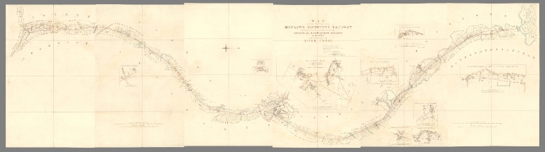
Author
[Vignoles, Charles Blacker, Midland Counties Railway Company]
Full Title
(Sheet 4) Map of that portion of the Midland Counties Railway extending from its junction with the London and Birmingham Railway at Rugby to the north side of the River Trent.
List No
10732.005
Note
Date estimated.
Author
[Vignoles, Charles Blacker, Midland Counties Railway Company]
Full Title
(Composite map of) (Sheets 1-6) Map of that portion of the Midland Counties Railway extending from its junction with the London and Birmingham Railway at Rugby to the north side of the River Trent.
List No
10732.008
Note
Date estimated.
Author
[Vignoles, Charles Blacker, Midland Counties Railway Company]
Full Title
(Sheet 1) Section of that Portion of the Midland Counties Railway, Extending from its junction with the London and Birmingham Railway near Rugby to the North Bank of the River Trent.
List No
10732.009
Note
Date estimated.
Author
[Vignoles, Charles Blacker, Midland Counties Railway Company]
Full Title
(Sheet 2) Section of that Portion of the Midland Counties Railway, Extending from its junction with the London and Birmingham Railway near Rugby to the North Bank of the River Trent.
List No
10732.010
Note
Date estimated.
Author
[Vignoles, Charles Blacker, Midland Counties Railway Company]
Full Title
(Composite map of) (Sheets 1- 2) Map of that portion of the Midland Counties Railway extending from the River Trent to Pinxton.
List No
10732.013
Note
Date estimated.
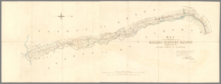
Author
[Vignoles, Charles Blacker, Midland Counties Railway Company]
Full Title
Section of that Portion of the Midland Counties Railway, Extending from the North Bank of the River Trent to its junction with the Pinxton and Mansfield Railway at Pinxton.
List No
10732.014
Note
Date estimated.
Author
[Vignoles, Charles Blacker, Midland Counties Railway Company]
Full Title
(Composite map of) (Sheets 1- 2) Map of that portion of the Midland Counties Railway extending between Derby and Nottingham.
List No
10732.017
Note
Date estimated.
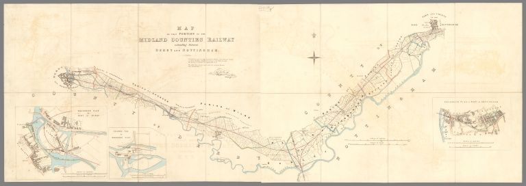
Author
[Vignoles, Charles Blacker, Midland Counties Railway Company]
Full Title
Section of that Portion of the Midland Counties Railway, Extending between Derby and Nottingham.
List No
10732.018
Note
Date estimated.
|


![[New York Baseball Schedule Map 1952] Take the Tube](https://www.davidrumsey.com/rumsey/Size2/RUMSEY~8~1/195/10950001.jpg)


![33. KATAΣTPOΦEΣ ΣIΔHPOΔPOMIKΩN ΓEΦYPΩN, ΣHPAΓΓΩN KAI AΛΛΩN EΓKATAΣTAΣEΩN. [Destruction of railway bridges, tunnels, etc.].](https://www.davidrumsey.com/rumsey/Size2/RUMSEY~8~1/195/14295077.jpg)