|
Author
Watson, Gaylord
Full Title
The American Republic and rail-road map of the United States, British Provinces, West-Indies, Mexico and Central America. Compiled from the latest official sources. Published by Gaylord Watson, 16 Beekman Street, New York. 1867. Entered ... 1866, by Gaylord Watson ... New York. Engraved by Fisk & Russell, N. York.
List No
5209.001
Note
First edition, not listed in Karrow or Modelski. Karrow shows editions of 1869 and 1870. Full color, with vignette title showing a large steam engine and, at the top, "Panoramic View of the Country between San Francisco and St. Louis." Population tables and tables of distances, listings of railroads. There is an inset map of Central America. This is one of the best pocket railroad maps of the period and one of the most decorative. Folded into stamped cloth covers 18x12 with "Watson's Rail-Road Map of the United States Mexico Etc." in gilt on the cover. Catalog of Watson's maps and charts on the inside cover with a paste down stamp of "H.T. Wright & Co... Kansas City, Missouri." Relief shown by hachures and spot heights. Prime meridians: Washington and Greenwich.
Author
Watson, Gaylord
Full Title
(Covers to) The American Republic and rail-road map of the United States, British Provinces, West-Indies, Mexico and Central America. Compiled from the latest official sources. Published by Gaylord Watson, 16 Beekman Street, New York. 1867. Entered ... 1866, by Gaylord Watson ... New York. Engraved by Fisk & Russell, N. York.
List No
5209A
Note
Stamped cloth covers 18x12 with "Watson's Rail-Road Map Of The United States Mexico Etc." in gilt on the cover. Catalog of Watson's maps and charts on the inside cover with a paste down stamp of "H.T. Wright & Co... Kansas City, Missouri."
Author
Watson, Gaylord
Full Title
(Inside Covers to) The American Republic and rail-road map of the United States, British Provinces, West-Indies, Mexico and Central America. Compiled from the latest official sources. Published by Gaylord Watson, 16 Beekman Street, New York. 1867. Entered ... 1866, by Gaylord Watson ... New York. Engraved by Fisk & Russell, N. York.
List No
5209B
Note
Inside front cover. List of maps, charts, guide books, etc. issued by Gaylord Watson with a paste down stamp of "H.T. Wright & Co... Kansas City, Missouri."
Author
Lloyd, J. T.
Full Title
Lloyd's official map of the state of Tennessee. Compiled from actual surveys and official documents, showing every rail road & rail road station with the distances between each station ... 1863. New York, J.T. Lloyd, Publisher, 164 Broadway. Price. 50 cents each, colored in sheets ... Entered ... 1862 by J.T. Lloyd ... N. York. (with) Eastern part of Tennessee.
List No
4817.001
Note
Entered in 1862. This was a companion map to Lloyd's Official Map of the State of Kentucky (our #4786) and issued from the same plate. If fact, almost all of Kentucky is shown on this map. Stephenson shows an edition of 1862, so this is the second edition. This copy backed with linen, as issued ("with linen backs for Army Officers $1.50"). The 1862 edition had battle sites underlined in red. Full color. Map is not dissected. Folds into pattered dark brown cloth covered boards 18.5x12 with ties. Battlefields not shown on this edition. Relief shown by hachures. Covers also most of Kentucky.
Author
Lloyd, J. T.
Full Title
(Covers to) Lloyd's official map of the state of Tennessee. Compiled from actual surveys and official documents, showing every rail road & rail road station with the distances between each station ... 1863. New York, J.T. Lloyd, Publisher, 164 Broadway. Price. 50 cents each, colored in sheets ... Entered ... 1862 by J.T. Lloyd ... N. York.
List No
4817A
Note
Pattered dark brown cloth covered boards 19 x 12 with ties.
Author
Spinner, Walther
Full Title
Simplon Orient-Express, la voie internationale la plus directe et la plus pittoresque
List No
15071.000
Note
Edition: Commission Romande de la Ligne du Simplon Lausanner (Gd-Pont 2 1947
Author
Miṣr. al-Jihāz al-Markazī lil-Taʻbiʼah al-ʻĀmmah wa-al-Iḥṣāʼ,
Full Title
السكك الحديدية = al-sikak al-ḥadīdīyah. (to accompany) الأطلس الإحصائي الجمهورية العربية المتحدة = al-Aṭlas al-iḥṣāʼ al-Jumhūrīyah al-ʻArabīyah al-Muttaḥidah. July 23, 1967.
List No
13681.081
Note
Statistical diagrams and charts, presenting the railway system to transport passengers and good, including the railway stations and number of passengers.
Author
[Geological Survey (U.S.), Shaw, W. James II., United States. Army]
Full Title
Major rail network : 1966 / W. James Shaw, II, U. S. Department of the Army, 1966.
List No
14359.174
Note
Transportation map representing the United States, featuring the geographic locations of the major railway network, including primary and secondary railroads, as of 1966. Map also shows political boundaries, time zones, topography, bodies of water, drainage, coastlines and islands. Relief shown with shading. Includes a legend, as well as a bar scale and scale statement. Presented with Albers Equal Area Projection. With two inset maps: Principal islands of Hawaii -- Alaska. Colored lithograph. Map is 43 x 66 cm, on double sheet 49 x 71 cm. Appears in Special subject maps section, subsection Economic : Transportation.
Author
Southern Pacific Railroad
Full Title
Map of California National Education Association Edition. Illustrating Its Climatolgy, Comparative Area, Reil Lines, Topography, Etc.
List No
15134.002
Author
[Arrowsmith, John, Edward Stanford Ltd., Stanford, Edward]
Full Title
Map of the Ionian Islands and Malta. Compiled from surveys & original documents in the Colonial Office, the Ordnance Department &c. by John Arrowsmith. (with) Map of the Maltese Islands from actual survey. (with) Map showing the chief routes from London to Bombay. London atlas series. Stanford's Geographical Establishment, London. London : Edward Stanford, 26 & 27, Cockspur St., Charing Cross, S.W. (1901)
List No
5075.056
Note
Full color. Relief shown by hachures. Map with 3 insets. Shows settlements, roads, etc. Map of Maltese Islands at 1:126,720 scale.
Author
[Weekly Dispatch, Weller, Edward, 1819-1884]
Full Title
Eastern Counties Railway : (Sheet 1, London to Ipswich Yarmouth & Norwich) -- (Sheet 2, London to Cambridge Ely & Norwich) / drawn & engraved by Edwd. Weller, 34 Red Lion Square ; E. Weller Lithogr.
List No
14360.065
Note
Eastern Counties Railway in England (Sheets 1 and 2). Shows political boundaries, counties, cities, railways, roads, canals, topography, vegetation, bodies of water, drainage, coastline, shoals and islands. Relief shown with contour lines. Includes latitudinal and longitudinal lines, as well as a legend and bar scale given in miles. With inset map: Harwich Branch. Hand-colored lithograph. Strip map divided into seven parts, together 45 x 65 cm, on two sheets, together 48 x 69 cm. Sheets presented in sequence. Appears in Vol. I : British.
Author
[Weekly Dispatch, Weller, Edward, 1819-1884]
Full Title
Great Northern Railway : (Sheet 1, London to Grantham & Nottingham) (Sheet 2, Continuation to York, Leeds &c.) / drawn & engraved by Edwd. Weller, 34 Red Lion Square ; E. Weller Lithogr.
List No
14360.066
Note
Map of the Great Northern Railway in England (Sheets 1 and 2). Shows political boundaries, counties, cities, railways, roads, canals, topography, vegetation, bodies of water and drainage. Relief shown with contour lines. Includes latitudinal and longitudinal lines, as well as a bar scale given in miles and compass roses. Hand-colored lithograph. Strip map divided into five parts, together 43 x 32 cm, on sheet 48 x 33 cm. Plate numbers for facing sheets handwritten in ink at upper left corner of sheet. Sheets 1 followed by maps entitled "(Sheet 2, Continuation to York, Leeds &c.) -- (Sheet 3, Loop or Lincolnshire Line from Peterborough)" on subsequent plates. Appears in Vol. I : British.
Author
[Weekly Dispatch, Weller, Edward, 1819-1884]
Full Title
Great Northern Railway : (Sheet 3, Loop or Lincolnshire Line from Peterborough) / drawn & engraved by Edwd. Weller, 34 Red Lion Square ; E. Weller Lithogr.
List No
14360.067
Note
Map of the Great Northern Railway in England (Sheet 3). Shows political boundaries, counties, cities, railways, roads, canals, topography, vegetation, bodies of water, drainage, coastlines and shoals. Relief shown with contour lines. Includes latitudinal and longitudinal lines, as well as a bar scale given in miles and compass roses. Hand-colored lithograph. Strip map divided into five parts, together 46 x 31 cm, on sheet 48 x 33 cm. Plate number handwritten in ink at upper right corner of sheet. Preceded by maps entitled "(Sheet 1, London to Grantham & Nottingham) -- (Sheet 3, Loop or Lincolnshire Line from Peterborough)" on previous plates. Appears in Vol. I : British.
Author
[Weekly Dispatch, Weller, Edward, 1819-1884]
Full Title
Great Western Railway : (Sheet 1, London to Reading, Oxford &c.) (Sheet IV, Oxford to Chester) / drawn & engraved by Edwd. Weller, 34 Red Lion Square ; E. Weller Lithogr.
List No
14360.068
Note
Map of the Great Western Railway in England (Sheets 1 and IV). Shows political boundaries, counties, cities, railways, roads, canals, topography, vegetation, bodies of water and drainage. Relief shown with contour lines. Includes latitudinal and longitudinal lines, as well as a bar scale given in miles and compass roses. Hand-colored lithograph. Strip map divided into five parts, together 45 x 32 cm, on sheet 48 x 33 cm. Plate numbers for facing sheets handwritten in ink at upper left corner of sheet; "4/8/60" in pencil at bottom of sheet. Followed by maps entitled (Sheet 2, Continuation to Bath and Bristol) -- (Sheet 3, Bristol to Exeter & Plymouth)" on subsequent plates. Appears in Vol. I : British.
Author
[Weekly Dispatch, Weller, Edward, 1819-1884]
Full Title
Great Western Railway : (Sheet 2, Continuation to Bath and Bristol) (Sheet 3, Bristol to Exeter & Plymouth)./ drawn & engraved by Edwd. Weller, 34 Red Lion Square ; E. Weller Lithogr.
List No
14360.069
Note
Map of the Great Western Railway in England (Sheets 2 and 3). Shows political boundaries, counties, cities, railways, roads, canals, topography, vegetation, bodies of water and drainage. Relief shown with contour lines. Includes latitudinal and longitudinal lines, as well as a bar scale given in miles and compass roses. Hand-colored lithograph. Strip map divided into four parts, together 44 x 31 cm, on sheet 48 x 33 cm. Plate numbers for facing sheets handwritten in ink at upper left corner of sheet; "25/8/61" in pencil at bottom of sheet. Preceded by maps entitled "(Sheet IV, Oxford to Chester) -- (Sheet IV, Oxford to Chester)" on previous plates; followed by "(Sheet 3, Bristol to Exeter & Plymouth)" on subsequent plate. Appears in Vol. I : British.
Author
[Weekly Dispatch, Weller, Edward, 1819-1884]
Full Title
London & Brighton Railway / drawn & engraved by Edwd. Weller, 34 Red Lion Square London ; E. Weller Lithogr.
List No
14360.070
Note
Map of the London & Brighton Railway in England. Shows political boundaries, counties, cities, railways, roads, canals, topography, vegetation, bodies of water, drainage and coastline. Relief shown with contour lines. Includes latitudinal and longitudinal lines, as well as a bar scale given in miles and compass roses. Hand-colored lithograph. Strip map divided into five parts, together 44 x 31 cm, on sheet 48 x 33 cm. Plate number handwritten in ink at upper right corner of sheet; "3/6/60" in pencil at bottom of sheet. Appears in Vol. I : British.
Author
[Weekly Dispatch, Weller, Edward, 1819-1884]
Full Title
North Western Railway : (Sheet 1, London to Birmingham) Sheet 2, Birmingham to Manchester & Liverpool)./ drawn & engraved by Edwd. Weller, 34 Red Lion Square ; E. Weller Lithogr.
List No
14360.071
Note
Map of the North Western Railway in England (Sheets 1 and 2). Shows political boundaries, counties, cities, railways, roads, canals, topography, vegetation, bodies of water, drainage and coastline. Relief shown with contour lines. Includes latitudinal and longitudinal lines, as well as a legend and bar scale given in miles. Hand-colored lithograph. Strip map divided into seven parts, together 45 x 65 cm, on two sheets, together 48 x 69 cm. Sheets presented in sequence. Appears in Vol. I : British.
Author
[Weekly Dispatch, Weller, Edward, 1819-1884]
Full Title
London & South-Western Railway / drawn & engraved by Edwd. Weller, 34 Red Lion Square ; E. Weller Lithogr.
List No
14360.072
Note
Map of the London & South-Western Railway in England. Shows political boundaries, counties, cities, railways, roads, canals, topography, vegetation, bodies of water, drainage, coastline, shoals and islands. Relief shown with contour lines. Includes latitudinal and longitudinal lines, as well as a legend, explanatory note and bar scale given in miles. Hand-colored lithograph. Strip map divided into four parts, together 65 x 45 cm, on double sheet 69 x 48 cm. Plate numbers handwritten in ink at lower and upper left corners of sheet; "20/5/60" in pencil at bottom of sheet. Appears in Vol. I : British.
Author
[Weekly Dispatch, Weller, Edward, 1819-1884]
Full Title
South Coast Railway : (Portsmouth to Brighton & Hastings) / drawn & engraved by Edwd. Weller, 34 Red Lion Square ; E. Weller Lithogr.
List No
14360.073
Note
Map of the South Coast Railway in England. Shows political boundaries, counties, cities, railways, roads, canals, topography, vegetation, bodies of water, drainage, coastline, shoals and islands. Relief shown with contour lines. Includes latitudinal and longitudinal lines, as well as a legend, explanatory note and bar scale given in miles. Hand-colored lithograph. Strip map divided into three parts, together 31 x 45 cm, on sheet 33 x 48 cm. Plate number handwritten in ink at lower and upper left corners of sheet; "22/7/60" in pencil at bottom of sheet. Appears in Vol. I : British.
Author
[Weekly Dispatch, Weller, Edward, 1819-1884]
Full Title
South Eastern Railway : (Dover & Hastings Branches) / drawn & engraved by Edwd. Weller, 34 Red Lion Square ; E. Weller Lithogr.
List No
14360.074
Note
Map of the South Eastern Railway in England. Shows political boundaries, counties, cities, railways, roads, canals, topography, vegetation, bodies of water, drainage, coastline, shoals and islands. Relief shown with contour lines. Includes latitudinal and longitudinal lines, as well as a legend and bar scale given in miles. Hand-colored lithograph. Strip map divided into three parts, together 45 x 31 cm, on sheet 48 x 33 cm. Plate number handwritten in ink at upper right corner of sheet; "1/7/60" in pencil at bottom of sheet. Appears in Vol. I : British.
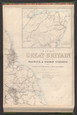
Author
[Weekly Dispatch, Weller, Edward, 1819-1884]
Full Title
Railway map of Great Britain : Showing all the railways, & railway stations, the canals, navigable rivers, & principal roads : (North east sheet) / by Edwd. Weller, F. R. G. S. ; engraved by Edwd. Weller, 34 Red Lion Square ; E. Weller Lithogr.
List No
14360.121
Note
Map of Great Britain, featuring railways and stations, canals, navigable rivers and roads (northeast sheet). Shows political boundaries, cities, railways, roads, canals, coal fields, bodies of water, drainage, coastlines, shoals and islands. Includes latitudinal and longitudinal lines, as well as a legend and bar scale given in British miles. With inset map: Continuation of Scotland. Hand-colored lithograph. Map is 65 x 46 cm, on double sheet 69 x 48 cm. Plate number handwritten in ink at lower left corner of sheet. Followed by maps entitled "(North west sheet) -- (South east sheet) -- (South west sheet)" on subsequent plates. Appears in Vol. I : British.
Author
[Weekly Dispatch, Weller, Edward, 1819-1884]
Full Title
Railway map of Great Britain : Showing all the railways, & railway stations, the canals, navigable rivers, & principal roads : (North west sheet) / by Edwd. Weller, F. R. G. S. ; engraved by Edwd. Weller, 34 Red Lion Square ; E. Weller Lithogr.
List No
14360.122
Note
Map of Great Britain, featuring railways and stations, canals, navigable rivers and roads (northwest sheet). Shows political boundaries, cities, railways, roads, canals, coal fields, bodies of water, drainage, coastlines, shoals and islands. Includes latitudinal and longitudinal lines. Hand-colored lithograph. Map is 65 x 46 cm, on double sheet 69 x 48 cm. Plate number handwritten in ink at lower left corner of sheet. Preceded by map entitled "(North west sheet)" on previous plate; followed by "(South east sheet) -- (South west sheet)" on subsequent plates. Appears in Vol. I : British.
Author
[Weekly Dispatch, Weller, Edward, 1819-1884]
Full Title
Railway map of Great Britain : Showing all the railways, & railway stations, the canals, navigable rivers, & principal roads : (South east sheet) / by Edwd. Weller, F. R. G. S. ; engraved by Edwd. Weller, 34 Red Lion Square ; E. Weller Lithogr.
List No
14360.123
Note
Map of Great Britain, featuring railways and stations, canals, navigable rivers and roads (southeast sheet). Shows political boundaries, cities, railways, roads, canals, coal fields, bodies of water, drainage, coastlines, shoals and islands. Includes latitudinal and longitudinal lines. With inset map: Railways in the vicinity of London. Hand-colored lithograph. Map is 65 x 46 cm, on double sheet 69 x 48 cm. Plate number handwritten in ink at lower left corner of sheet. Preceded by maps entitled "(North west sheet) -- (North west sheet)" on previous plates; followed by "(South west sheet)" on subsequent plate. Appears in Vol. I : British.
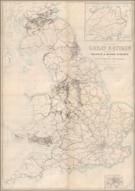
Author
[Weekly Dispatch, Weller, Edward, 1819-1884]
Full Title
Railway map of Great Britain : Showing all the railways, & railway stations, the canals, navigable rivers, & principal roads : (South west sheet) / by Edwd. Weller, F. R. G. S. ; engraved by Edwd. Weller, 34 Red Lion Square ; E. Weller Lithogr.
List No
14360.124
Note
Map of Great Britain, featuring railways and stations, canals, navigable rivers and roads (southwest sheet). Shows political boundaries, cities, railways, roads, canals, coal fields, bodies of water, drainage, coastlines, shoals and islands. Includes latitudinal and longitudinal lines. Hand-colored lithograph. Map is 65 x 46 cm, on double sheet 69 x 48 cm. Plate number handwritten in ink at lower left corner of sheet. Preceded by maps entitled "(North west sheet) -- (North west sheet) -- (South east sheet)" on previous plates. Appears in Vol. I : British.
Author
[Weekly Dispatch, Weller, Edward, 1819-1884]
Full Title
(Composite Map to) Railway map of Great Britain : Showing all the railways, & railway stations, the canals, navigable rivers, & principal roads : (North east sheet) -- (North west sheet) -- (South east sheet) -- (South west sheet) / by Edwd. Weller, F. R. G. S. ; engraved by Edwd. Weller, 34 Red Lion Square ; E. Weller Lithogr.
List No
14360.125
Note
Composite map of Great Britain, featuring railways and stations, canals, navigable rivers and roads (northeast, northwest, southeast and southwest sheets). Shows political boundaries, cities, railways, roads, canals, coal fields, bodies of water, drainage, coastlines, shoals and islands. Includes latitudinal and longitudinal lines, as well as a legend and bar scale given in British miles. With two inset maps: Continuation of Scotland -- Railways in the vicinity of London. Hand-colored lithograph. Map is 130 x 92 cm, on four double sheets, together 138 x 96 cm. Sheets presented in sequence. Appears in Vol. I : British.
Author
شكوفه مقبل [Şukufe Mukbil]
Full Title
(European Russia with railroads)
List No
10992.009
Note
Dimensions are sheet size.
Author
شكوفه مقبل [Şukufe Mukbil]
Full Title
(Great Britain and Ireland)
List No
10992.013
Note
Dimensions are sheet size.
Author
شكوفه مقبل [Şukufe Mukbil]
Full Title
(Italy with railroads)
List No
10992.014
Note
Dimensions are sheet size.
Author
شكوفه مقبل [Şukufe Mukbil]
Full Title
(The Caucasus with railroads)
List No
10992.021
Note
Dimensions are sheet size.
Author
شكوفه مقبل [Şukufe Mukbil]
Full Title
(Japan and Korea with railroads)
List No
10992.026
Note
Dimensions are sheet size.
Author
شكوفه مقبل [Şukufe Mukbil]
Full Title
(Tunisia with railroads)
List No
10992.030
Note
Dimensions are sheet size.
Author
شكوفه مقبل [Şukufe Mukbil]
Full Title
(Libya)
List No
10992.031
Note
Dimensions are sheet size.
Author
شكوفه مقبل [Şukufe Mukbil]
Full Title
(Egypt with railroads)
List No
10992.032
Note
Dimensions are sheet size.
Author
شكوفه مقبل [Şukufe Mukbil]
Full Title
(North and Central America with Railroads)
List No
10992.038
Note
Dimensions are sheet size.
Author
شكوفه مقبل [Şukufe Mukbil]
Full Title
(Rivers of South America)
List No
10992.039
Note
Dimensions are sheet size.
Author
شكوفه مقبل [Şukufe Mukbil]
Full Title
(United States with railroads)
List No
10992.041
Note
Dimensions are sheet size.
Author
شكوفه مقبل [Şukufe Mukbil]
Full Title
(South America with Railroads)
List No
10992.045
Note
Dimensions are sheet size. Has flag of Argentina on opposite page.
Author
شكوفه مقبل [Şukufe Mukbil]
Full Title
(Australia with neighboring islands and railroads)
List No
10992.049
Note
Dimensions are sheet size.
Author
Hudson & Manhattan Rail Road
Full Title
[New York Baseball Schedule Map 1952] Take the Tube
List No
10950.001
Author
Cram, George Franklin
Full Title
Cram's Rail Road & Township Map of Washington. Published by Geo. F. Cram. Proprietor of the Western Map Depot. 66, Lake St. Chicago Ills. 1875.
List No
5370.034
Note
Map in full color by county. Railroad lines clearly shown. (Note: The map has been rotated 90 degrees clockwise for readability.)
Author
Lewis, Samuel, 1782-1865
Full Title
Map of Ireland, divided into provinces & counties, shewing the principal roads, railways, rivers & canals, & the distance in Irish miles & furlongs of each city & post town from Dublin. Drawn by R. Creighton. Engraved by I. Dower for Lewis's Atlas of Ireland. (to accompany) Lewis's Atlas comprising the counties of Ireland. London : Published by S. Lewis and Co., 1846.
List No
13536.004
Note
Hand colored in outline folded map. Shows cities, post towns, villages, mail and other roads, rivers, canals, railroads, and boundaries of provinces and counties. Includes explanation of map symbols.
Author
Cram, George Franklin
Full Title
Cram's Rail Road & Township Map of Oregon. Published by Geo. F. Cram. Proprietor of the Western Map Depot. 66, Lake St. Chicago Ills. 1875.
List No
5370.035
Note
Map in full color by county. Railroad lines clearly shown. (Note: The map has been rotated 90 degrees counterclockwise for readability.)
Author
Lewis, Samuel, 1782-1865
Full Title
A plan of London and its environs. Drawn by R. Creighton. Engraved by J. & C. Walker. (to accompany) Atlas to the Topographical dictionaries of England and Wales ... Published by S. Lewis and Co,. M.DCCC.XLIV (1844).
List No
13535.004
Note
Detailed plan of the city of London and surrounding areas on folded sheet, showing city boundary, borough, land marks, buildings, etc. Includes coats of arms at upper panel.
Author
[Berezin, A.D., 9]
Full Title
(Moskva=Moscow). 5. Rost material'nogo i kul'turnogo urovnia trudyashchikhsia. (to accompany) Sotsialisticheskoe Stroitel'stvo Soyuza Sovetskikh Sotsialisticheskikh Respublik.
List No
13676.135
Note
Untitled pictorial map of Moscow. Showing landmarks and rivers. legend showing operating metro lines, under construction and projected lines.
Author
[Glinka, Grigorii Viacheslavich, 1862-1934, Russia. Pereselencheskoe upravlenīe.]
Full Title
(Text Page to) No. 58. Karta putey soobshcheniya Aziatskoy Rossii. (to accompany) Atlas Aziatskoi Rossii. Izdanie. 1914.
List No
13437.088
Note
Descriptive text to railway system map of Asian Russia, with 2 plans of Amur Railway system and designed direction of the South Siberian railway.
Author
[Canet Alvarez, Gerardo A., 1911-, Raisz, Erwin, 1893-1968, Harvard University. Institute of Geographical Exploration, Cuba. Ministerio de Agricultura]
Full Title
Patron de vida.
List No
14350.019
Note
Map showing the human geography of Cuba. Title translates to: Life patterns Features roads, railways, population and water consumption in the country. Includes a bar scale. With views comparing urban and rural communities. With charts depicting the economy, tracing changes in the twentieth century. Accompanied by descriptive text, which appears in Spanish, with English translations.
Author
[Geographia Map Co., Pennsylvania Railroad]
Full Title
The Complete Map of New York (Manhattan) Featuring House Numbers, Transit Lines, Playgrounds, Wading Pools, etc.
List No
15000.000
Author
[Suomen Maantieteellinen Seura, Tilgmann, Ferdinand, 1832-1911]
Full Title
No. 27. Kulkuneuvot. = Kommunikationer. Aktiebolaget F. Tilgmann, Helsingfors 1897.
List No
14366.039
Note
Transportation map of Finland. Features railways, roads, trails and canals in 1897. Also shows cities, railways, bodies of water, drainage, coastlines and islands. Includes latitudinal and longitudinal lines, as well as a legend, bar scale and scale statement. Colored lithograph. Map is 58 x 41 cm, on double sheet 60 x 43 cm. Text presented in parallel Finnish and Swedish.
Author
Fullarton, A. & Co.
Full Title
Railway Map of the British Isles exhibiting all the railways & canals in England, Scotland & Ireland completed or in progress with their respective stations. By J. Bartholomew Junr. Edinr. F.R.G.S. XXIV. (with) six inset maps: Enlarged Section of the South Yorkshire and Lancashire Districts; Railways Around London; Birmingham; Manchester; Edinburgh; Glasgow. Engraved by J. Bartholomew, Edinr. A. Fullarton & Co. Edinburgh, London & Dublin.
List No
3007.024
Note
In full color. Railways shown in red; railways under construction shown with dotted red lines. Lists included of references to railways in England, Scotland, and Ireland.
Author
Cram, George Franklin
Full Title
Cram's Rail Road & Township Map of Indiana. Published by Geo. F. Cram. Proprietor of the Western Map Depot. 66, Lake St. Chicago Ills. 1875.
List No
5370.012
Note
Map in full color by county. The railroad lines are clearly marked.
|


![[New York Baseball Schedule Map 1952] Take the Tube](https://www.davidrumsey.com/rumsey/Size2/RUMSEY~8~1/195/10950001.jpg)


