|
REFINE
Browse All : Railroad of Utah
1-29 of 29
Author
[Hayden, Ferdinand Vandeveer, 1829-1887, Russell, Andrew Joseph, 1830-1902]
Full Title
Serrated rocks or Devil's Slide, (Near view) - Weber Cañon, Utah. (to accompany) Sun pictures of Rocky Mountain scenery ... by F. V. Hayden, ... New York : Julius Bien, 1870.
List No
13389.025
Note
Black and white view, shows limestone formations forming a giant chute along the side of the mountain.
Author
[Hayden, Ferdinand Vandeveer, 1829-1887, Russell, Andrew Joseph, 1830-1902]
Full Title
Trestle work : Promontory Point, Salt Lake Valley. (to accompany) Sun pictures of Rocky Mountain scenery ... by F. V. Hayden, ... New York : Julius Bien, 1870.
List No
13389.032
Note
Black and white view, shows Central Pacific Railroad construction at Promontory Point in Salt Lake Valley.
Author
Union Pacific Railway Company.
Full Title
World's pictorial line : birdseye view of the great Salt Lake Basin reached via the Union Pacific, the overland route. Knight, Leonard & Co., Printers and engravers, Chicago, Ill. Copyrighted. 1893, by E.L. Lomax, General passenger and ticket agent, Union Pacific System, Omaha, Neb.
List No
13206.003
Note
Color pictorial map, on sheet 114 x 45, folded to 23 x 10. Title from cover, with 28 pages of text. On verso 24 pages of text "Sights and scenes in Idaho and Montana", on recto text pages 25-28. Includes logo of "Union Pacific, the overland route" on cover. Map shows major cities, routes, rivers and mountains. Relief shown pictorially.
Author
Leahy, J.F.
Full Title
(Index to) Leahy's Hotel Guide and Railway Distance Maps. Texas. Utah.
List No
0425.118
Note
Texas and Utah alphabetical index list of the Hotels of the town with the number of rooms of each, their rates per day and the population of the town. Includes population of the states, Explanation of abbreviation of the railroad of the state, and advertisement.
Author
Leahy, J.F.
Full Title
Leahy's Hotel Guide and Railway Distance Map of the State of Utah. Published by American Hotel Register Company. Leahy Build., 228-234 W. Ontario St., Chicago, Ill. Copyrighted by J.F. Leahy, Jan., 1934.
List No
0425.119
Note
Map printed without color. Includes name of the railroad entering the town, and distance between towns.
Author
[Beckwith, Lieut., Schumann, C.]
Full Title
Weber Lower Canyon. April 5th at 2 P.M. from an island in Weber River; Valley of Great Salt Lake. C. Schumann from F.W. Egloffstein. Selmar Siebert's Engraving & Printing Establishment, Washington, D.C. U.S.P.R.R. Exp. & Surveys 41st Parallel. Expl. by Lieut. Beckwith. Vol. II.
List No
0693.005
Note
View without color. The "Wah-satch Mountains" are in the background.
Author
[Beckwith, Lieut., Hinshelwood, R., Schumann, C.]
Full Title
Second or Sheeprock Canyon of Weber River. April 6th at 1 P.M. View Looking East. C. Schumann from F.W. Egloffstein. R. Hinshelwood. U.S.P.R.R. Exp. & Surveys 41st Parallel. Expl. by Lieut. Beckwith. Vol. II.
List No
0693.006
Note
View uncolored.
Author
[Beckwith, Lieut., Schumann, C.]
Full Title
Porcupine Terrace. Uintah Mountains in the Distance. Camp. April 16th to 17th. C. Schumann from F.W. Egloffstein. Selmar Siebert's Engraving & Printing Establishment, Washington, D.C. U.S.P.R.R. Exp. & Surveys 41st Parallel. Expl. by Lieut. Beckwith. Vol. II.
List No
0693.007
Note
Uncolored engraving shows the Bear River and the Uintah Mountains.
Author
[Beckwith, Lieut., Schumann, C.]
Full Title
Round Prairie From Head of the Same. April 21st at 10 A.M. C. Schumann from F.W. Egloffstein. S.V. Hunt Sc. U.S.P.R.R. Exp. & Surveys 41st Parallel. Expl. by Lieut. Beckwith. Vol. II.
List No
0693.008
Note
Uncolored view includes the Timpanogos River and Canyon.
Author
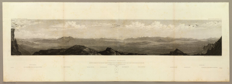
[Beckwith, Lieut., Schumann, C.]
Full Title
Goshoot Passage showing 65 miles of the proposed line of railroad from the desert west of Great Salt Lake to the Humboldt Mountains. May 17th-20th. C. Schumann from F.W. Egloffstein. Selmar Siebert's Engraving & Printing Establishment, Washington, D.C. U.S.P.R.R. Exp. & Surveys 41st Parallel. Expl. by Lieut. Beckwith. Vol. II.
List No
0693.009
Note
Uncolored view includes Don-Don Mountain, Wa-cho-i Mountain, Mo-ko-ga-ri Butte, the Wa-ro-ja Mountains, Franklin valley and lake, and the eastern foot of the Humboldt Mountains.
Author
Beckwith, E.G.
Full Title
From the Valley of Green River to the Great Salt Lake; from Explorations and Surveys made under the direction of the Hon. Jefferson Davis Secretary of War by Capt. E.G. Beckwith, 3d. Artillery. F.W. Egloffstein, Topographer for the Route. 1855. Explorations and surveys for a railroad route from the Mississippi River to the Pacific Ocean. War Department. Route near the 41st Parallel. Map No. 1. Selmar Siebert's Engraving & Printing Establishment. Washington, D.C.
List No
0693.028
Note
Detailed map from just above the 38th parallel up to the 42nd parallel. Uncolored.
Author
Beckwith, E.G.
Full Title
From Great Salt Lake to the Humboldt Mountains; from Explorations and Surveys made under the direction of the Hon. Jefferson Davis Secretary of War by Capt. E.G. Beckwith, 3d. Artillery. F.W. Egloffstein, Topographer for the Route. 1855. Explorations and surveys for a railroad route from the Mississippi River to the Pacific Ocean. War Department. Route near the 41st Parallel. Map No. 2. Selmar Siebert's Engraving & Printing Establishment. Washington, D.C.
List No
0693.029
Note
Uncolored map includes the area from the Great Salt Lake to Humboldt pass. Path clearly laid out for the proposed railway route.
Author
Gunnison, J.W.
Full Title
From the Coo-che-to-pa Pass to the Wahsatch Mountains; from Explorations and Surveys made under the direction of the Hon. Jefferson Davis Secretary of War by Capt. J.W. Gunnison. Topl. Engrs. assisted by Capt. E.G. Beckwith 3d Artillery. R.H. Kern Topographer in the field. Map made under the supervision of Capt. E.G. Beckwith 3d Artillery by F.W. Egloffstein, Topographer for the Route. 1855. Explorations and surveys for a railroad route from the Mississippi River to the Pacific Ocean. War Department. Route near the 38th & 39th Parallels. Map No. 4. Engr. by Selmar Siebert.
List No
0693.036
Note
Map spans the region from Sahwatch Creek (Colorado) in the east, through the Black Canyon of the Gunnison, and then along the Colorado River into Utah.
Author
[Hayden, Ferdinand Vandeveer, 1829-1887, Russell, Andrew Joseph, 1830-1902]
Full Title
Thousand Mile Tree : Wilhelmina's Pass. (to accompany) Sun pictures of Rocky Mountain scenery ... by F. V. Hayden, ... New York : Julius Bien, 1870.
List No
13389.023
Note
Black and white view, shows thousand mile point on the Central Pacific Railroad at a cut through Wilhelmina's Pass.
Author
[Hayden, Ferdinand Vandeveer, 1829-1887, Russell, Andrew Joseph, 1830-1902]
Full Title
Wilhelmina's Pass : distant view of serrated rocks or Devil's Slide, Weber Cañon, Utah. (to accompany) Sun pictures of Rocky Mountain scenery ... by F. V. Hayden, ... New York : Julius Bien, 1870.
List No
13389.024
Note
Black and white view, shows aerial view of railroad tracks alongside a river at Wilhelmina's Pass, Weber Canyon, Utah.
Author
[Hayden, Ferdinand Vandeveer, 1829-1887, Russell, Andrew Joseph, 1830-1902]
Full Title
Tunnel no. 3 : Weber Cañon, Utah. (to accompany) Sun pictures of Rocky Mountain scenery ... by F. V. Hayden, ... New York : Julius Bien, 1870.
List No
13389.026
Note
Black and white view, shows railroad tracks across a river and into a tunnel in the mountainside, Weber Canyon, Utah.
Author
Cram, George Franklin, 1841-1928
Full Title
Utah. 1899, by Geo. F. Cram.
List No
14372.213
Note
Map of Utah. Shows political boundaries, counties, towns, railroads, topography, bodies of water, drainage, coastlines and islands. Relief shown with hachures. Includes key with explanation, latitudinal and longitudinal lines, as well as a bar scale given in miles. With alphanumeric grid corresponding to "Index of Utah" on page 391. Colored lithograph. Map is 55 x 38 cm, on double sheet 67 x 45 cm. "Index of maps" and "Index of cities" in margins, providing navigation for atlas as a whole.
Author
C.C. Pierce & Co.
Full Title
Oregon and the Pacific Northwest. (Published by Ellis A. Davis. Berkeley, Cal. Seattle. 1909)
List No
2134.030
Note
Four reproductions of photographs. Contents: The Oregon State Capitol, Salem. By courtesy of the Salem Chamber of Commerce -- Along the Columbia River, Northern Oregon -- Reminiscences of the Old Pioneer Days; stage coaching in an Oregon Valley / copyright 1904 by C.C. Pierce & Co. 2075 -- Driving the golden spike that united the Union Pacific and Southern Pacific railways. "Unless otherwise credited, by courtesy of the Pacific Coast Magazine, Portland."
Author
Cram, George Franklin
Full Title
Utah.
List No
2809.062
Note
Locations of banking towns shown by red circles. Railroads are indicated by numbers and colors and patterns, and each railroad has the same number and color and pattern in every state through which it passes. All railroads on each map are in a list keyed to the map. Border of map has a table of contents for the atlas. Relief shown by hachures. Prime meridians Washington D.C. and Greenwich.
Author
[Central Pacific Railroad Company, Union Pacific Railroad Company]
Full Title
(Covers to) The only great through all rail route is the Union and Central Pacific R.R. line via Omaha ... Rand, McNally & Co., Printers Engravers, etc., 108 West Randolph St., Chicago ... Through time table, in effect January 1, 1872.
List No
4107A
Author
[Central Pacific Railroad Company, Union Pacific Railroad Company]
Full Title
(Text Page to) The only great through all rail route is the Union and Central Pacific R.R. line via Omaha ... Rand, McNally & Co., Printers Engravers, etc., 108 West Randolph St., Chicago ... Through time table, in effect January 1, 1872. (with) Map of rail & stage route to Big Tree Groves and Yosemite. (with) New mining map of Utah compiled from U.S. Govt. Surveys ... Nat. Railway Public Co., Philadelphia.
List No
4107.001
Note
10 p. on 1 sheet. Includes tables and text, an ad for Froiseth's new sectional and mineral map of Utah, and 2 maps. Big Tree Groves and Yosemite map at (ca. 1:1,900,000) scale. Utah map at (ca. 1:1,800,000). Relief shown by hachures. Utah map shows mining districts, etc.
Author
[Central Pacific Railroad Company, Union Pacific Railroad Company]
Full Title
(Text Page to) The only great through all rail route is the Union and Central Pacific R.R. line via Omaha ... Rand, McNally & Co., Printers Engravers, etc., 108 West Randolph St., Chicago ... Through time table, in effect January 1, 1872.
List No
4107B
Note
Contains time table and 8 views.
Author
Cram, George Franklin
Full Title
Cram's Rail Road & Township Map of Utah.
List No
4533.031
Author
Cram, George Franklin
Full Title
New Rail Road and County Map of Utah.
List No
4558.052
Author
Cram, George Franklin
Full Title
Railroad and County Map of Utah. Geo. F. Cram. Engraver and Publisher, Chicago.
List No
4727.053
Note
Prime meridians Washington D.C. and Greenwich. Relief shown by hachures. With printed color.
Author
Rand McNally and Company
Full Title
Commercial Atlas of America. Rand McNally Black and White Mileage Map, Utah and Colorado.
List No
5028.131
Note
Shows railroads and distances.
Author
Rand McNally and Company
Full Title
Commercial Atlas of America. Rand McNally Standard Map of Utah.
List No
5028.132
Note
Shows railroads and distances. Includes tables of principal cities and railroads, keyed to map. Relief shown by hachures.
Author
Rand McNally and Company
Full Title
Commercial Atlas of America. Rand McNally Auto Trails Map, District No. 13. Montana, Wyoming, N.W. Colorado, East. Idaho, Nor. Utah, N.E. Nevada.
List No
5028.143
Note
Shows roads and distances. Shows table of highway names, numbers, and markings. Relief shown by hachures.
Author
Cram, George Franklin
Full Title
Cram's Rail Road & Township Map of Utah. Published by Geo. F. Cram. Proprietor of the Western Map Depot. 66, Lake St. Chicago Ills. 1875.
List No
5370.032
Note
Map in full color by county. Railroad lines clearly shown.
1-29 of 29
|