|
Author
Leahy, J.F.
Full Title
Chart of Distances Between Important Cities of the United States.
List No
0425.147
Note
Table of distances "compiled from the war Department's Official table of distances, and other reliable sources."
Author
Leahy, J.F.
Full Title
Leahy's Railway Distance Map of the United States. Published by American Hotel Register Company. Leahy Building 228-234 W. Ontario street, Chicago. (Copyrighted).
List No
0425.148
Note
Map printed without color. The railway lines shown in red and back. All lines represent the train routes and the mileage between points.
Author
Leahy, J.F.
Full Title
Leahy's Railway Distance Map of the United States. Published by American Hotel Register Company. Leahy Building 228-234 W. Ontario street, Chicago. (Copyrighted).
List No
0425.149
Note
Map printed without color. The railway lines shown in red and back. All lines represent the train routes and the mileage between points.
Author
Leahy, J.F.
Full Title
Leahy's Railway Distance Map of the United States. Published by American Hotel Register Company. Leahy Building 228-234 W. Ontario street, Chicago. (Copyrighted).
List No
0425.150
Note
Map printed without color. The railway lines shown in red and back. All lines represent the train routes and the mileage between points.
Author
Lizars, William Home, 1788-1859
Full Title
United States & Texas. With all the railways and canals. Published by W. Lizars, Edinburgh. (to accompany) Lizars' Edinburgh Geographical General Atlas ... 1841.
List No
0438.074
Note
Double page engraved hand colored in outline. Relief shown by hachures. Shows "Republic of Texas," the eastern United States and its western territories, Indian settlements, towns, roads, railroads, rivers, canals and mountains. Prime meridian is Greenwich.
Author
Mitchell, Samuel Augustus
Full Title
(Covers to) Mitchell's Compendium Of The Internal Improvements Of The United States; Comprising General Notices Of All The Most Important Canals and Rail-Roads... Philadelphia: Published By Mitchell & Hinman, No. 6, North-Fifth Street. 1838. (on verso) Entered ... 1835, by Mitchell & Hinman ... Pennsylvania. Stereotyped by John Fagan ... Philadelphia. (with) Mitchell's Map Of The United States Showing the Principal Travelling, Turnpike and Common Roads ... Philadelphia: Published By S. Augustus Mitchell. 1838. Sold by Mitchell & Hinman. No. 6 North Fifth Street. Entered ... 1835, by S. Augustus Mitchell... Pennsylvania. (with 8 inset maps).
List No
0521.001
Note
The second edition. No obvious changes noted from the 1835 edition of the map. Full color. 84 Page book is bound into patterned teal blue cloth covers with "The American Traveller, And Guide Through The United States." on cover label. Four page catalogue of Mitchell's maps.
Author
Mitchell, Samuel Augustus
Full Title
(Title Page to) Mitchell's Compendium Of The Internal Improvements Of The United States; Comprising General Notices Of All The Most Important Canals and Rail-Roads... Philadelphia: Published By Mitchell & Hinman, No. 6, North-Fifth Street. 1838. (on verso) Entered ... 1835, by Mitchell & Hinman ... Pennsylvania. Stereotyped by John Fagan ... Philadelphia. (with) Mitchell's Map Of The United States Showing the Principal Travelling, Turnpike and Common Roads ... Philadelphia: Published By S. Augustus Mitchell. 1838. Sold by Mitchell & Hinman. No. 6 North Fifth Street. Entered ... 1835, by S. Augustus Mitchell... Pennsylvania. (with 8 inset maps).
List No
0521.002
Note
The second edition. No obvious changes noted from the 1835 edition of the map. Full color. 84 Page book is bound into patterned teal blue cloth covers with "The American Traveller, And Guide Through The United States." on cover label. Four page catalogue of Mitchell's maps.
Author
Mitchell, Samuel Augustus
Full Title
Mitchell's Map Of The United States Showing the Principal Travelling, Turnpike and Common Roads ... Philadelphia: Published By S. Augustus Mitchell. 1838. Sold by Mitchell & Hinman. No. 6 North Fifth Street. Entered ... 1835, by S. Augustus Mitchell... Pennsylvania. (with 8 inset maps. (with) Mitchell's Compendium Of The Internal Improvements Of The United States; Comprising General Notices Of All The Most Important Canals and Rail-Roads... Philadelphia: Published By Mitchell & Hinman, No. 6, North-Fifth Street. 1838. (on verso) Entered ... 1835, by Mitchell & Hinman ... Pennsylvania. Stereotyped by John Fagan ... Philadelphia.
List No
0521.003
Note
The second edition. No obvious changes noted from the 1835 edition of the map. Full color. 84 Page book is bound into patterned teal blue cloth covers with "The American Traveller, And Guide Through The United States." on cover label. Four page catalogue of Mitchell's maps.
Author
Mitchell, Samuel Augustus Jr.
Full Title
Railroad map of the United States, showing the through lines of communication from the Atlantic to the Pacific, together with the various steamship lines along the seaboard. Copyright by Wm. M. Bradley & Bro. 1884.
List No
0592.010
Note
Red printed colored lines. Relief shown by hachures. Shows settlements, rivers, named railroads and steamship lines, etc. Prime meridians: Greenwich and Washington.
Full Title
Railroad map of the United States, showing the through lines of communication from the Atlantic to the Pacific, together with the various steamship lines along the seaboard. Copyright 1886 by Wm. M. Bradley & Bro. (1890)
List No
0594.009
Note
Colored map. Relief shown by hachures. Shows settlements, rivers, named railroads and steamship lines, etc. Prime meridians: Greenwich and Washington.
Author
[Pacific Railroad Survey, Warren, Gouverneur Kemble, 1830-1882]
Full Title
(Covers to) Reports of Explorations and Surveys, to Ascertain the Most Practicable and Economical Route for a Railroad From the Mississippi River to the Pacific Ocean. Made Under the Direction of the Secretary of War, In 1853-56, According to Acts of Congress of March 3, 1853, May 31, 1854, and August 5, 1854. Volume XI. Washington: George W. Bowman, Printer. 1861. 36th Congress, 2d Session, Senate, Ex. Doc.
List No
0693A
Author
[Pacific Railroad Survey, Warren, Gouverneur Kemble, 1830-1882]
Full Title
(Title Page to) Reports of Explorations and Surveys, to Ascertain the Most Practicable and Economical Route for a Railroad From the Mississippi River to the Pacific Ocean. Made Under the Direction of the Secretary of War, In 1853-56, According to Acts of Congress of March 3, 1853, May 31, 1854, and August 5, 1854. Volume XI. Washington: George W. Bowman, Printer. 1861. 36th Congress, 2d Session, Senate, Ex. Doc.
List No
0693B
Note
This Quarto issue of the report is the House issue, except for volume XI which is the Senate issue. W. Heckrotte has an unusual copy of the Warren U.S. map found in this report. It is dissected on linen and is an earlier version of the map published with the Quarto report. It has 40 authorities vs. 42 in the quarto issue map, shorter note to left of authorities, lots of plate differences, especially: nothing in Owyhee area, differences in N.M., Calif., etc. Looks like someone asked for the map before it was finished -see the Lack of ocean lines in the top half south of Gray's Harbor. In 13 volumes. Bound in full leather with "Explorations and Surveys for a Railroad to the Pacific Ocean" and the volume number on the spine in gold.
Author
[Pacific Railroad Survey, Warren, Gouverneur Kemble, 1830-1882]
Full Title
(Contents Page to) Reports of Explorations and Surveys, to Ascertain the Most Practicable and Economical Route for a Railroad From the Mississippi River to the Pacific Ocean. Made Under the Direction of the Secretary of War, In 1853-56, According to Acts of Congress of March 3, 1853, May 31, 1854, and August 5, 1854. Volume XI. Washington: George W. Bowman, Printer. 1861. 36th Congress, 2d Session, Senate, Ex. Doc.
List No
0693C
Note
"Contents of volume XI."
Author
[Pacific Railroad Survey, Warren, Gouverneur Kemble, 1830-1882]
Full Title
(Title Page to) Memoir to accompany the Map of the territory of the United States from the Mississippi River to the Pacific Ocean, giving a brief account of each of the exploring expeditions since A.D. 1800, with a detailed description of the method adopted in compiling the general map. By Lieut. Gouverneur K. Warren, Corps of Topographical Engineers, U.S.A. 1859.
List No
0693D
Author
[Pacific Railroad Survey, Warren, Gouverneur Kemble, 1830-1882]
Full Title
(Contents Page to) Memoir to accompany the Map of the territory of the United States from the Mississippi River to the Pacific Ocean, giving a brief account of each of the exploring expeditions since A.D. 1800, with a detailed description of the method adopted in compiling the general map. By Lieut. Gouverneur K. Warren, Corps of Topographical Engineers, U.S.A. 1859.
List No
0693E
Note
"List of illustrations."
Author
[Pacific Railroad Survey, Warren, Gouverneur Kemble, 1830-1882]
Full Title
(Title Page to) Topographical maps, profiles, and sketches to illustrate the various Reports of Surveys for railroad routes from the Mississippi River to the Pacific Ocean. Washington, D.C., 1861.
List No
0693F
Author
[Pacific Railroad Survey, Warren, Gouverneur Kemble, 1830-1882]
Full Title
(Contents Page to) Topographical maps, profiles, and sketches to illustrate the various Reports of Surveys for railroad routes from the Mississippi River to the Pacific Ocean. Washington, D.C., 1861.
List No
0693G
Author
[Pacific Railroad Survey, Warren, Gouverneur Kemble, 1830-1882]
Full Title
(Contents Page to) Topographical maps, profiles, and sketches to illustrate the various Reports of Surveys for railroad routes from the Mississippi River to the Pacific Ocean. Washington, D.C., 1861.
List No
0693H
Author
[Abbot, Henry L., Humphreys, A.A., Warren, Gouverneur Kemble, 1830-1882]
Full Title
Profiles of the main routes surveyed, compiled in 1855, by Lieutenants G.K. Warren & H.L. Abbot, Corps Topl. Engineers; with revisions and additional compilations from the results of subsequent examinations and surveys. Prepared in the Office of Pacific Rail Road Explorations and Surveys. Captain A.A. Humphreys, Corps Topl. Engineers, in charge, by direction of Hon. Jefferson Davis, Secretary of War. 1856. Explorations and Surveys for the Rail Road Routes from the Mississippi River to the Pacific Ocean, War Department. (with) Profiles of rail roads constructed across the Alleghany mountains.
List No
0693.019
Note
Uncolored map profiles with inset profile. Printed on 2 sheets; joined as 1.
Author
Rand McNally and Company
Full Title
The Rand-McNally Official Railway Guide Map. Corrected To November 1st, 1877. (inset) Vicinity Of Boston. (inset) Vicinity Of New York And Philadelphia. (on verso) Rand-McNally Official Railway Guide Map of the Territories and the Pacific Coast.
List No
0748.001
Note
Full color by state.; Western states shown on verso without color. Advertisements, and "Table of comparison, showing the difference in time of different localities." on verso. Relief shown by hachures. Prime meridian is Greenwich.
Author
Rand McNally and Company
Full Title
Rand-McNally Official Railway Guide Map of the Territories and the Pacific Coast. (on verso)The Rand-McNally Official Railway Guide Map. Corrected To November 1st, 1877. (inset) Vicinity Of Boston. (inset) Vicinity Of New York And Philadelphia.
List No
0748.002
Note
Uncolored map of Western states.; Eastern states shown on verso in full color by state. Includes advertisements, and "Table of comparison, showing the difference in time of different localities." Relief shown by hachures. Prime meridian is Greenwich.
Author
Rand McNally and Company
Full Title
(Covers to) United States. Rand, McNally & Co., Map Publishers and Engravers, Chicago, 1898. Rand, McNally & Co.'s New Business Atlas Map of the United States. Copyright, 1895, by Rand, McNally & Co. (inset) Alaska. (on verso) Chicago To Denver. Rand, McNally & Co.'s New Commercial Railroad Map of the United States. Copyright, 1898, ... 1896 ... (with) East of Chicago ... (with 2 inset maps). (on verso) Denver To Pacific Coast ...
List No
0772.001
Note
Four full printed color maps from large U.S. Commercial Map. Folded into brown card board covers 17x11 printed with "Rand-McNally New Commercial Map Of The United States In Section. East Of Chicago. Chicago To Denver. Denver To Pacific Coast. United States In One Map. Rand, McNally & Co., Publishers, Chicago And New York." Prime meridian is Greenwich, Relief shown by hachures.
Author
Rand McNally and Company
Full Title
United States. Rand, McNally & Co., Map Publishers and Engravers, Chicago, 1898. Rand, McNally & Co.'s New Business Atlas Map of the United States. Copyright, 1895, by Rand, McNally & Co. (inset) Alaska. (on verso) Chicago To Denver. Rand, McNally & Co.'s New Commercial Railroad Map of the United States. Copyright, 1898, ... 1896 ... (with) East of Chicago ... (with 2 inset maps). (on verso) Denver To Pacific Coast ...
List No
0772.002
Note
Four full printed color maps from large U.S. Commercial Map. Folded into brown card board covers 17x11 printed with "Rand-McNally New Commercial Map Of The United States In Section. East Of Chicago. Chicago To Denver. Denver To Pacific Coast. United States In One Map. Rand, McNally & Co., Publishers, Chicago And New York." Prime meridian is Greenwich, Relief shown by hachures.
Author
Rand McNally and Company
Full Title
United States. Rand, McNally & Co., Map Publishers and Engravers, Chicago, 1898. Rand, McNally & Co.'s New Business Atlas Map of the United States. Copyright, 1895, by Rand, McNally & Co. (inset) Alaska. (on verso) Chicago To Denver. Rand, McNally & Co.'s New Commercial Railroad Map of the United States. Copyright, 1898, ... 1896 ... (with) East of Chicago ... (with 2 inset maps). (on verso) Denver To Pacific Coast ...
List No
0772.003
Note
Four full printed color maps from large U.S. Commercial Map. Folded into brown card board covers 17x11 printed with "Rand-McNally New Commercial Map Of The United States In Section. East Of Chicago. Chicago To Denver. Denver To Pacific Coast. United States In One Map. Rand, McNally & Co., Publishers, Chicago And New York." Prime meridian is Greenwich, Relief shown by hachures.
Author
Rand McNally and Company
Full Title
United States. Rand, McNally & Co., Map Publishers and Engravers, Chicago, 1898. Rand, McNally & Co.'s New Business Atlas Map of the United States. Copyright, 1895, by Rand, McNally & Co. (inset) Alaska. (on verso) Chicago To Denver. Rand, McNally & Co.'s New Commercial Railroad Map of the United States. Copyright, 1898, ... 1896 ... (with) East of Chicago ... (with 2 inset maps). (on verso) Denver To Pacific Coast ...
List No
0772.004
Note
Four full printed color maps from large U.S. Commercial Map. Folded into brown card board covers 17x11 printed with "Rand-McNally New Commercial Map Of The United States In Section. East Of Chicago. Chicago To Denver. Denver To Pacific Coast. United States In One Map. Rand, McNally & Co., Publishers, Chicago And New York." Prime meridian is Greenwich, Relief shown by hachures.
Author
Rand McNally and Company
Full Title
United States. Rand, McNally & Co., Map Publishers and Engravers, Chicago, 1898. Rand, McNally & Co.'s New Business Atlas Map of the United States. Copyright, 1895, by Rand, McNally & Co. (inset) Alaska. (on verso) Chicago To Denver. Rand, McNally & Co.'s New Commercial Railroad Map of the United States. Copyright, 1898, ... 1896 ... (with) East of Chicago ... (with 2 inset maps). (on verso) Denver To Pacific Coast ...
List No
0772.005
Note
Four full printed color maps from large U.S. Commercial Map. Folded into brown card board covers 17x11 printed with "Rand-McNally New Commercial Map Of The United States In Section. East Of Chicago. Chicago To Denver. Denver To Pacific Coast. United States In One Map. Rand, McNally & Co., Publishers, Chicago And New York." Prime meridian is Greenwich, Relief shown by hachures.
Author
Rand McNally and Company
Full Title
(Covers to) (Rand, McNally & Co.'s New Official Railroad Map Of The United States And Dominion Of Canada). Compiled from the most reliable sources, and engraved by Rand, McNally & Co., Map Engravers and Publishers, 160-174 Adams Street, Chicago, Ill. The Rand-McNally Railway Guide Map. Copyright, 1901, ... 1892 ... (with 8 inset maps).
List No
0776.001
Note
Map is untitled, title above it taken from covers. Population statistics are given for each state and larger city. The insets are titled: Porto Rico, San Juan (Porto Rico Island), Islands East Of Porto Rico, Philippine Islands, Hawaii, Western Islands of Hawaii, Alaska, and one untitled map of the Aleutian Islands. Map is full printed color by state, folded into brown card board covers 16x9 printed with "Rand, McNally & Co.'s New Official Railroad Map Of The United States And Dominion Of Canada. Rand, McNally & Company, Publishers, Chicago - New York." Prime meridian is Greenwich. Relief shown by hachures.
Author
Rand McNally and Company
Full Title
(Rand, McNally & Co.'s New Official Railroad Map Of The United States And Dominion Of Canada). Compiled from the most reliable sources, and engraved by Rand, McNally & Co., Map Engravers and Publishers, 160-174 Adams Street, Chicago, Ill. The Rand-McNally Railway Guide Map. Copyright, 1901, ... 1892 ... (with 8 inset maps).
List No
0776.002
Note
Map is untitled, title above it taken from covers. Population statistics are given for each state and larger city. The insets are titled: Porto Rico, San Juan (Porto Rico Island), Islands East Of Porto Rico, Philippine Islands, Hawaii, Western Islands of Hawaii, Alaska, and one untitled map of the Aleutian Islands. Map is full printed color by state, folded into brown card board covers 16x9 printed with "Rand, McNally & Co.'s New Official Railroad Map Of The United States And Dominion Of Canada. Rand, McNally & Company, Publishers, Chicago - New York." Prime meridian is Greenwich. Relief shown by hachures.
Author
Rand McNally and Company
Full Title
Rand McNally standard map of the United States. Copyright by Rand McNally & Company, Chicago. Made in U.S.A.
List No
0813.001
Note
Relief shown by spot heights. Full color by state. Shows railroads, canals, national parks and monuments, Indian reservations, etc.
Author
Snyder, Van Vechten & Co.
Full Title
New rail road map of the United States. (Compiled and published by Snyder, Van Vechten & Co., Milwaukee. 1878)
List No
0936.010
Note
Hand col. lithographed map. Relief shown by hachures. Includes 2 small views.
Author
Tanner, Henry S.
Full Title
The Travellers Guide Or Map Of the Roads, Canals & Rail Roads Of The United States, With the Distances From Place To Place. By H.S. Tanner. (to accompany) The American Traveller; Or Guide Through the United States. Containing Brief Notices of the Several States, Cities, Principal Towns ... Third Edition. By H.S. Tanner. Philadelphia: Published by the Author, No. 51 South Third Street. 1837. (on verso) Entered ... 1834, by H.S. Tanner ... Pennsylvania.
List No
0978.003
Note
Full color map. With References and 18 inset maps. 3rd edition; 1st was 1834; map unchanged. Catalog of Tanner's works at end of book. 144 page Guide Book with four maps of city plans. Fifth map is a large colored map entitled, "The Traveller's Guide or Map of the Roads, Canals & Rail Roads of the United States, With the distances from place to place by H.S. Tanner." At bottom of map, "Entered ... 1834, by H.S. Tanner ... Pennsylvania." Bound with linen embossed with a rose pattern. Label on cover states, "Tanner's American Traveller, or Guide through the United States."
Author
Tanner, Henry S.
Full Title
Profile of the Erie Canal N.Y. ; Profile of the Ohio Canal ; Profile of the Chesapeake & Ohio Canal. (with inset profile) Baltimore & Ohio railroad. (to accompany) A Description of the Canals and Railroads of the United States.
List No
0979.005
Note
Three profiles on one page.
Author
Tanner, Henry S.
Full Title
Florida Canal ; Morris Canal N. J. ; Union Canal Pa. ; Schuylkill Navigation Penn. ; Profile of the Pennsylvania Canal. (with inset profile) Columbia railroad Pa. (to accompany) A Description of the Canals and Railroads of the United States.
List No
0979.006
Note
Six profiles on one page.
Author
Tanner, Henry S.
Full Title
Map of the canals & railroads of the United States, reduced from the large map of the U.S. by H. S. Tanner. Published T. R. Tanner & J. Disturnell, 124 Broadway, New York, 1840. Engraved by J. Knight. Entered ... 1840, by T.R. Tanner ... Pennsylvania. ( inset continuation map of ) South part of Florida ; Chesapeake & Delaware Canal ; Dismal Swamp Canal ; Welland Canal ; Lehigh navigation.
List No
0979.010
Note
Map shows canals and roads in color, folded into brown cloth covered boards. With one inset and four cross sections. Includes explanation. Prime meridian is Washington.
Author
Tanner, Henry S.
Full Title
The Travellers Guide or Map of the Roads, Canals & Rail Roads of The United States, With the Distances From Place to Place. By H.S. tanner 1844. Published by H.S. Tanner... Philadelphia. Entered ... 1834, by H.S. Tanner ... Pennsylvania.
List No
0983.003
Note
Full color map. With references and 11 insets showing major cities. Rail Roads are hand colored in red. Bookplate of Tanner's Map Store, N.Y. 144 page Guide Book. Includes maps and reference guides. New copyright notice of 1844 indicating that this is a very late edition; the map is changed from the earlier editions but is still copyright 1834, as in the earlier editions. Full color map entitled, "The Travellers Guide or Map of The Roads, Canals & Rail Roads of the United States, With the distances from place to place by H.S. Tanner 1844." at bottom, "Entered ... 1834, by H.S. Tanner ... Pennsylvania." Bound in linen with gild title, "Tanner's American Traveller or Guide through the United States with Maps, Plans &c."
Author
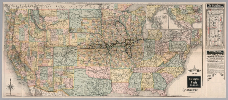
Chicago, Burlington & Quincy Railroad Company
Full Title
Correct map of the Burlington Route C.B. & Q.R.R. and connecting lines. Copyright 1883 by Rand, McNally & Co., Chicago.
List No
10091.003
Note
Edition for September 1885. Relief shown by hachures. Covers U.S. except for southern parts of Texas and Florida and eastern and northern Maine. Includes inset maps of the route from Chicago to Australia and "Map showing location of railroad depots, public buildings, etc. in Chicago," and text. Printed in full color.
Author
Tunis, W.E.
Full Title
Tunis' New Colored Railroad Map Of The United States & Canadas. Revised And Corrected Every Month. William E. Tunis, Bookseller and Stationer, 153 Jefferson Avenue, Detroit, Michigan ... Entered ... 1859, by W.E. Tunis ... New York.
List No
1014.000
Note
Map is in black and white with railroad lines shown in red. "The continuous red lines represent rail roads completed. The dotted red lines represent roads projected." With a view of a train traveling across a bridge, engraved by J.W. Orr in New York.
Author
شكوفه مقبل [Şukufe Mukbil]
Full Title
(North and Central America with Railroads)
List No
10992.038
Note
Dimensions are sheet size.
Author
شكوفه مقبل [Şukufe Mukbil]
Full Title
(United States with railroads)
List No
10992.041
Note
Dimensions are sheet size.
Author
Union Pacific Railroad Company
Full Title
Geographically correct map of the United States, issued by Union Pacific Railroad. Rand McNally & Company, Chicago. Copyright, 1942 by C. J. Collins Union Pacific Railroad. (insets) Union Pacific Railroad, connecting lines over Pacific Ocean. (with) Union Pacific Railroad, connecting lines over Atlantic Ocean. (cover title) Military map of the United States. The progressive Union Pacific Railroad. 6-52544. Printed in U.S.A. Copyright 1944. Rand McNally, Chicago.
List No
11259.003
Note
Color map of the United States on sheet 46x81, folded to 23x10. Showing state boundaries, place names, roads, rivers, railroad stations, locations of air fields, naval and army installations. Text on verso includes List of military posts, strategic middle routes and location of Union Pacific Offices.
Author
[Whitney-Graham Company, Inc., Southern Railway (U.S.), Funk & Wagnalls Company.]
Full Title
Map of the Southern railway system. 1929. The Southern Railway. 2-29. (to accompany) The blue book of map making : America's map makers. R.W.C. The Whitney-Graham Co. Inc. (insets) Southern Florida. (with) Cuba.
List No
11489.020
Note
Color map of the Southern and Eastern States. Showing state boundaries, cities, towns and roads. Southern Railway single and double tracks in red and tracks operated separately shown in blue. Includes station index and legend.
Author
[Walling, H.F., Hitchcock, C.H.]
Full Title
Railroad Map of the United States.
List No
1149.027
Note
Hand tinted in full color.
Author
[Union Atlas Co., Warner & Beers]
Full Title
New railroad map of the United States, and Dominion of Canada. (Union Atlas Co., Warner & Beers, Proprietors. Lakeside Building Cor: of Clark & Adams Sts. Chicago. 1876. Entered ... 1876 by Warner & Beers ... Washington D.C.)
List No
1159.144
Note
Col. lithographed map. Relief shown by hachures. Includes small view below title.
Author
Atchison, Topeka and Santa Fe Railway Co.
Full Title
Santa Fe - The Atchison, Topeka and Santa Fe Railway Co. and Connections.
List No
12045.024
Note
Two page (four panel) spread.
Author
[Cram, George F., Bennett, J.Q.A., Beers, J.H.]
Full Title
United States.
List No
12048.008
Author
J.L. Smith Co.
Full Title
Locomotive Map of the United States.
List No
12339.000
Author
Rand McNally and Company
Full Title
Southern Pacific's Four Great Routes to the West Coast.
List No
12341.000
Note
Date estimated.
Author
Lloyd, James T.
Full Title
Lloyd's Map of the Lower Mississippi River from St. Louis to the Gulf of Mexico.
List No
12387.002
Note
Made up of 5 map panels which form a single map, when assembled (see our composite map, List No. 12387.003).
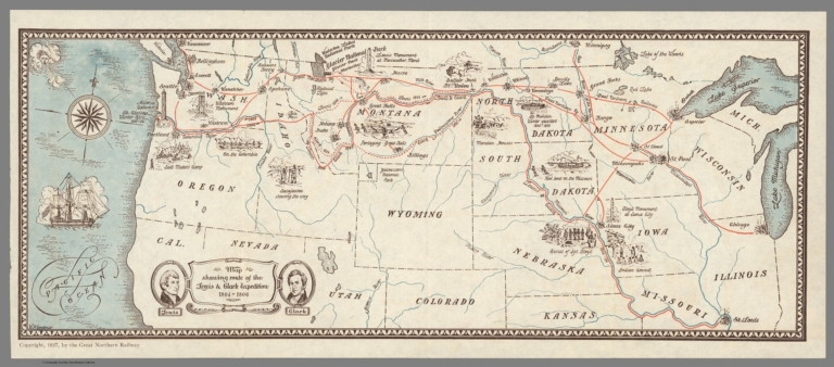
Author
Gordenier, W.H.
Full Title
Map showing route of the Lewis & Clark Expedition 1804-1806.
List No
12414.000
Note
Also shows route of the Great Northern Railway.
Author
[James, Kerns & Abbott Co., Southern Pacific Lines]
Full Title
Southern Pacific Lines.
List No
12457.003
Note
Date estimated.
|