|
Author
A. Phillips & Co.
Full Title
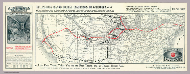
Phillips Tourist Excursions. 1880. 1896. The Great Rock Island Route. A. Phillips & Co., Phillips-Rock Island Excursions, No. 296 Washington Street, Boston. Knight, Leonard & Co., Engravers, Chicago ... Phillips-Rock Island Excursions to California ...
List No
5279.001
Note
Relief shown by hachures. Railroad route printed in red.
Author
A. Phillips & Co.
Full Title
(Covers to) Phillips Tourist Excursions. 1880. 1896. The Great Rock Island Route. Take The every week one way personally conducted "From anywhere east to everywhere west." Boston, Buffalo, Chicago ... and all points in California and the Pacific Coast ... A. Phillips & Co. ...
List No
5279A
Author
A. Phillips & Co.
Full Title
(Text Page to) Phillips Tourist Excursions. 1880. 1896. The Great Rock Island Route. Take The every week one way personally conducted "From anywhere east to everywhere west." Boston, Buffalo, Chicago ... and all points in California and the Pacific Coast ... A. Phillips & Co.
List No
5279B
Note
(6) p. on 1 sheet. Tourist information, time tables and self wrapper.
Author
New York Central Railroad Company
Full Title
Map of the New York Central Lines ... The Matthews-Northrup Works, Buffalo, N.Y.
List No
5285.003
Note
Covers area from Boston to St. Louis and from Quebec to Richmond, Va. Includes text, illus., and map: Map of Chicago showing location of New York Central Lines city ticket offices ...
Author
Chicago, Burlington & Quincy Railroad Company
Full Title
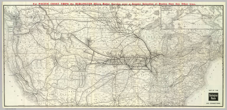
Map of the Burlington Route and connections. Poole Bros. Chicago. 5-20-'07 ... (inset map) Direct routes to the Orient. Great Northern Steamship Co. and Chicago, Burlington & Quincy Railway Company.
List No
5286.001
Note
Relief shown by hachures. Covers U.S. and southern Canada except for southern Texas, Louisiana and Florida, and northern Maine. Inset map: scale (ca. 1:100,000,000); "6-19-'05." Line of text in red in upper margin.
Author
Chicago, Burlington & Quincy Railroad Company
Full Title
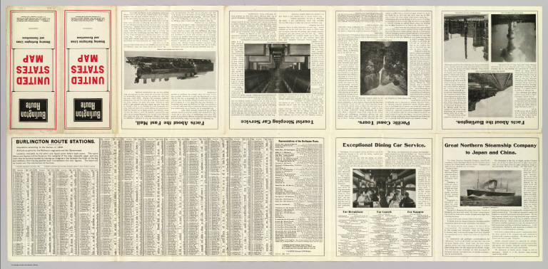
(Covers to) Burlington Route. United States map showing Burlington Lines and connections ...
List No
5286A
Author
Chicago, Burlington & Quincy Railroad Company
Full Title
(Text Page to) Burlington Route. United States map showing Burlington Lines and connections ...
List No
5286B
Note
Text, photos, timetables.
Author
Lloyd, J. T.
Full Title
Lloyd's New Map of the United States The Canadas and New Brunswick From The Latest Surveys Showing Every Railroad & Station Finished to June 1862... 1866. (On verso: ) Lloyd's Topographical Railway Map of North America or the United States Continent in 1900....
List No
2859.002
Note
Two sided wall map -see 1866 copy. On this side, in addition to the U.S. map, there are insets of major cities and their rail lines. Similar to the 1866 edition, but some changes - on the verso North America map, adds inset of South America, the Pacific Railway route has been changed to go north of Salt Lake, some of the ads on the steamship routes have been deleted.
Author
Rand McNally and Company
Full Title
Rand McNally & Co.'s New Railroad Junction Point And County Map Of The Eastern & Middle States. Prepared from the Latest Government Surveys, and Verified by the Working Time Tables of the Various Railroads. Drawn, Engraved, Printed, Colored By Hand And Published By Rand McNally & Co., Chicago. The Railroads on this Map are bought up to date of September 1885. Copyright, 1882, By Rand, McNally & Co. (inset) General Map Of The United States Of America Showing The Relative Geographical Position Of The Several States And Territories.
List No
3117.000
Note
Copyright 1882. Inset map of the United States. 1 of six sections. Very large map of the northeast and middle coastal areas, which, although complete by itself, was also part of a twelve sheet map in six parts (two sheets to each part) that extended west to the 105th parallel and south to Florida and measured 10x15 feet (see Modelski). All the existing railroads are shown in great detail at a scale of six miles to one inch. Because of it great size, the map was hand colored. Dissected into 49 sections and backed with linen. See our 5802.000 for a related map. Folds into dark blue cloth covered boards 31x23.
Author
Rand McNally and Company
Full Title
(Composite Map of) Rand, McNally & Co.'s New Shippers' Railroad Map of the United States. Scale: 8 miles to one inch. Showing all railroads, each in a separate color, and all railroad stations in large, plain type. This is the El Paso section only, of the above named map. (Below the neatline) Rand, McNally & Co.'s New Shippers' Railroad Map of the United States, Copyright, 1888 by Rand, McNally & Co. Copyright, 1891 by Rand, McNally & Co.
List No
5802.017
Note
This is a composite of all 13 maps. The owner of the 13 maps did not include the 2 western maps in this group for some reason, roughly Dakota and Indian Territory, or they may have been lost over time. Each set of these maps was made to order custom by Rand McNally so it is possible that these 13 maps comprise the entire set. The other 2 maps of the western US to the pacific are in the set but they are at a smaller scale so they are not in this composite image.
Author
Rand McNally and Company
Full Title
Rand, McNally & Co's. New Commercial Railroad Map Of The United States With Portions Of The Dominion Of Canada, The Republic Of Mexico, And The West Indies. Compiled from the most reliable sources, and engraved by Rand, McNally & Co., Map Engravers and Publishers, 160-174 Adams Street, Chicago, Ill. 1907.
List No
5413.001
Note
The full printed color map is folded into a cloth covered brown binding 17x11 with gilt letters stating "Rand, McNally & Co's New Commercial Map Of The United States And Adjacent Portions Of Canada, Mexico, And The West Indies."
Author
Rand McNally and Company
Full Title
(Covers to) Rand, McNally & Co's. New Commercial Railroad Map Of The United States With Portions Of The Dominion Of Canada, The Republic Of Mexico, And The West Indies. Compiled from the most reliable sources, and engraved by Rand, McNally & Co., Map Engravers and Publishers, 160-174 Adams Street, Chicago, Ill. 1907.
List No
5413A
Note
The full printed color map is folded into a cloth covered brown binding 17x11 with gilt letters stating "Rand, McNally & Co's New Commercial Map Of The United States And Adjacent Portions Of Canada, Mexico, And The West Indies."
Author
Tanner, Henry S.
Full Title
(Title Page to) A Connected View of The Whole Internal Navigation of the United States; ... Corrected and Improved From the Edition of 1826, And Much Enlarged, ... With A Sheet Map, ... The Map Has Been Engraved For the Purpose ... On A Reduced Scale, From Tanner's Excellent Four Sheet Map of the United States, Recently Published. ... By a Citizen of the United States. Philadelphia: Published by the Author ... Printed by Lydia R. Bailey. 1830. (on verso) ...on the seventeenth day of April ... 1830, George Armroyd ... hath deposited ... a Book ... Pennsylvania.
List No
3067A
Author
Tanner, Henry S.
Full Title
A Connected View of The Whole Internal Navigation of the United States; ... Corrected and Improved From the Edition of 1826, And Much Enlarged, ... With A Sheet Map, ... The Map Has Been Engraved For the Purpose ... On A Reduced Scale, From Tanner's Excellent Four Sheet Map of the United States, Recently Published. ... By a Citizen of the United States. Philadelphia: Published by the Author ... Printed by Lydia R. Bailey. 1830. (on verso) ...on the seventeenth day of April ... 1830, George Armroyd ... hath deposited ... a Book ... Pennsylvania.
List No
3067.001
Note
2nd (and best) edition, first with Tanner's Map of the Canals and Railroads of the United States. The map is copyright 1830. The book lists over 150 canals and navigation improvements in great detail. The map shows the most important canals and two railroads in operation, and one proposed railroad (the Great Western Railroad, from New York to the Mississippi River)plus two others. The canals and railroad lines are in color. The first edition appeared in 1826 with 10 maps but without the Tanner map (see our copy #4214). Tanner in 1834 and 1840 (see our copies, #2655 and #979) published a book on Canals and Railroads that uses the same map, updated. Modelski lists the 1834 Tanner map as "one of the earliest general maps of the eastern United States showing railroads in operation." Since this 1830 copy is an earlier state of the same map, it probably qualifies as the true "first." Two folding plates of profiles of canals and railroads at the back. Not in Streeter, Eberstadt, or Graff. Bound in half leather boards with "A Connected View" on the spine.
Author
Canada Government Railways
Full Title
Map Shewing the Railways of Canada to Accompany Annual Report on Railway Statistics. 1886. Collingwood Schreiber, Chief Engineer and General Manager of Government Railways. Office Of The Chief Engineer And General Manager Of Government Railways. Compiled by E.V. Johnson, M.C.S.C.E., In charge of Draughting Offices. Drawn by A.M. Edmonds. The Burland Lithographic Co. Montreal. (seal) Department Of Railways And Canals Canada. (in red) Railways Of Canada. In Operation And Under Construction. 31st December, 1886 ...
List No
0121.001
Note
Accompanies the Annual Report on Railway Statistics. With full printed color, the railways shown in red. The map is in two sheets, each dissected into 54 sections. The map sheets are folding with marbled end sheets and a brown cloth slip case 21x14 with a label reading "Canadian Dominion. London: Edward Stanford, Wholesale & Retail Mapseller, &c. 55, Charing Cross. Schreiber ..."
Author
Canada Government Railways
Full Title
(Covers to) Map Shewing the Railways of Canada to Accompany Annual Report on Railway Statistics. 1886. Collingwood Schreiber, Chief Engineer and General Manager of Government Railways. Office Of The Chief Engineer And General Manager Of Government Railways. Compiled by E.V. Johnson, M.C.S.C.E., In charge of Draughting Offices. Drawn by A.M. Edmonds. The Burland Lithographic Co. Montreal. (seal) Department Of Railways And Canals Canada. (in red) Railways Of Canada. In Operation And Under Construction. 31st December, 1886 ...
List No
0121A
Note
Accompanies the Annual Report on Railway Statistics. With full printed color, the railways shown in red. The map is in two sheets, each dissected into 54 sections. The map sheets are folding with marbled end sheets and a brown cloth slip case 21x14 with a label reading "Canadian Dominion. London: Edward Stanford, Wholesale & Retail Mapseller, &c. 55, Charing Cross. Schreiber ..."
Author
Galveston, Houston, & Henderson Railroad
Full Title
United States of America.
List No
5179.002
Note
Partial color with Texas in pink.
Author
Rand McNally and Company
Full Title
Commercial Atlas of America. Black and White Mileage Map of the United States (eastern half).
List No
5028.006
Note
Shows railroad lines and destinations.
Author
Rand McNally and Company
Full Title
Commercial Atlas of America. Black and White Mileage Map of the United States (western half).
List No
5028.007
Note
Shows railroad lines and destinations.
Author
Rand McNally and Company
Full Title
(Composite of) Commercial Atlas of America. Black and White Mileage Map of the United States.
List No
5028.008
Note
Shows railroad lines and destinations.
Author
Rand McNally and Company
Full Title
(Text Page) Commercial Atlas of America. Shortest Railroad Travel Distance Tables of the United States.
List No
5028M
Note
International travel distance tables by states.
Author
Rand McNally and Company
Full Title
(Text Page) Commercial Atlas of America. Shortest Railroad Travel Distance Tables of the United States.
List No
5028N
Note
International travel distance tables by states.
Author
Rand McNally and Company
Full Title
(Text Page) Commercial Atlas of America. Travel Distance Table.
List No
5028O
Note
Travel distance tables including some overseas destinations.
Author
Rand McNally and Company
Full Title
(Text Page) Alphabetical List of All Railroads.
List No
5028R
Note
Railroads include Canada, Mexico, Cuba, Puerto Rico, and Hawaii.
Author
Rand McNally and Company
Full Title
(Text Page) Alphabetical List of All Railroads.
List No
5028S
Note
Railroads include Canada, Mexico, Cuba, Puerto Rico, and Hawaii.
Author
Rand McNally and Company
Full Title
(Text Page) Alphabetical List of All Railroads.
List No
5028T
Note
Railroads include Canada, Mexico, Cuba, Puerto Rico, and Hawaii.
Author
Rand McNally and Company
Full Title
(Text Page) Alphabetical List of All Railroads. Railroads Grouped by Systems.
List No
5028U
Note
Railroads include Canada, Mexico, Cuba, Puerto Rico, and Hawaii.
Author
New England Railway Publishing Company
Full Title
ABC The Pathfinder Railway Guide Map, Western Section. (insets) Alaska. Yellowstone Park. Philippine Islands. Hawaiian Islands.
List No
9060.000
Author
Haasis & Lubrecht
Full Title
The American Union Railroad Map Of The United States, British Possessions, West Indies, Mexico, And Central America. 1871. Published by Haasis & Lubrecht, 107 Liberty Street, New York. Smith & McDougal, Electrotypers, 82 Beekman Street, New York. (inset) Central America.
List No
3822.000
Note
This is a reworking of the Lubrecht and Rosa map "The American Continent" of 1864, and the first edition, first issue in a new format. Statistics at the top of the 1864 map are here replaced with a view "From the Atlantic to the Pacific Ocean" emphasizing the recently completed transcontinental railroad. Also, an elaborate title and view of a steam engine and train station have replaced the more subdued 1864 title. Population tables of the United States are added to the left and right sides of the map. The map itself has been updated to show political and some topographical changes of the ensuing seven years. Projected railroad lines are shown running everywhere in the west. The coloring is very bright, to match the decidedly optimistic (expansionist) flavor of the map. D.L. Guernsey published editions of 1871 and 1874 in Concord New Hampshire, with no major changes in the map. WH has an 1873 edition by Haasis and Lubrecht that adds text next to the population figures, more railroads, no changes in topography. Issued in a cover with a label in German from Wilhelm Lubrecht in Stuttgart, Germany, indicating it may have been sold to emigrants. Full color. Map has green paper edging, is dissected into 16 sections, and fold into a new gray cloth folding case 35x27 with "American Union Railroad Map Haasis & Lubrecht 1871" stamped in gilt on the spine.
Author
[Pershing, John J. (John Joseph), 1860-1948, Geological Survey (U.S.)]
Full Title
Map of France superimposed on that of the United States : Showing relative distances and the extent of railroad systems used by the American Expeditionary Forces. House Doc. No. 626; 66th Cong., 2d Sess. Engraved and printed by the U. S. Geological Survey.
List No
14379.023
Note
Military map of France, overlaid upon the United States in order to show the relative distances between different cities. Features the railroad systems used by the American Expeditionary Forces during World War I. Shows political boundaries, cities, drainage, coastlines and islands. Includes a legend, explanatory notes and two bar scales given in kilometers and miles, as well as a compass rose with north oriented toward top of sheet (for the United States). Colored engraving. Map is 20 x 24 cm, on fold-out sheet 23 x 27 cm.
Author
Rand McNally and Company
Full Title
Miles of railroads in the United States, 1830-1893. Miles of railroads, by states, January 1st, 1894. Freight traffic on the Great Lakes, by ports, 1889. Rand, McNally & Co., Engravers, Chicago. (1897)
List No
3565.114
Note
Three statistical charts. "Rand, McNally & Company's" in upper margin.
Author
Snyder, Van Vechten & Co.
Full Title
New rail road map of the United States. (Compiled and published by Snyder, Van Vechten & Co., Milwaukee. 1878)
List No
0936.010
Note
Hand col. lithographed map. Relief shown by hachures. Includes 2 small views.
Author
[Union Atlas Co., Warner & Beers]
Full Title
New railroad map of the United States, and Dominion of Canada. (Union Atlas Co., Warner & Beers, Proprietors. Lakeside Building Cor: of Clark & Adams Sts. Chicago. 1876. Entered ... 1876 by Warner & Beers ... Washington D.C.)
List No
1159.144
Note
Col. lithographed map. Relief shown by hachures. Includes small view below title.
Author
Watson, Gaylord
Full Title
(Covers to) Watson's New County and Railroad Map of the United States and the Dominion of Canada Compiled From the Latest Official Sources, 1874. Published by Gaylord Watson, 16 Beekman St., New York. Entered ... 1871, by Gaylord Watson ... Washington. (with) 5 inset maps: Routes of the Union, Central & Kansas Pacific Railroad; Vicinity of Boston; Vicinity of Philadelphia; Vicinity of New York; Lower Part of Florida.
List No
2540A
Note
5 inset maps, Vignette of Locomotive under title. Shows the route of the "Proposed Atlantic and Great Western Canal." Also an inset of the Union, Central & Kansas Pacific Railroad. Population tables, statistics, etc. Highly detailed map showing railroads and counties and cities in the eastern part of the U.S. and Canada. Has "United States" on the cover and is the companion map to the Map of the Western States... with "Territories" (see #2539.000) on its cover. Copyright date is 1871. For some reason, Modelski does not list all these early Watson maps, but only a few maps dated 1874 and later; perhaps Watson did not deposit all his maps with the LOC.
Author
Watson, Gaylord
Full Title
(Covers to) Watson's new rail-road and distance map of the United States and Canada. Compiled from the latest official sources. Published by Gaylord Watson, 16 Beekman Street, New York. 1871. Entered ... 1868, by Gaylord Watson ... New York. Engraved by Fisk & Russell, N. York. (with) Routes Of The Union Pacific Railroads. (with) Vicinity of New York. (with) Vicinity of Philadelphia. (with) Vicinity of Boston.
List No
3436A
Note
With the railroad engine "San Francisco" as the cartouche. Shows railroad lines of the eastern half of the U.S. going west to Nebraska and Texas. Includes 4 inset maps. Copyrighted in 1868, although Modelski shows no earlier edition than 1871. With lists of all the railroads in the United States, length of track and cost of road and equipment. The style of the map is very different from the later Watson maps of the mid 1870's -- it is more diagrammatic, showing only the railroads and drainage and political boundaries. Catalogue of Watson's maps on inside front cover. Outline color by state; covers are dark brown cloth 18 x 12 stamped with "Watson's rail-road and distance map of United States and Canada." Prime meridians: Greenwich and Washington.
Author
Watson, Gaylord
Full Title
Watson's New County and Railroad Map of the United States and the Dominion of Canada Compiled From the Latest Official Sources, 1874. Published by Gaylord Watson, 16 Beekman St., New York. Entered ... 1871, by Gaylord Watson ... Washington. (with) 5 inset maps: Routes of the Union, Central & Kansas Pacific Railroad; Vicinity of Boston; Vicinity of Philadelphia; Vicinity of New York; Lower Part of Florida.
List No
2540.001
Note
5 inset maps, Vignette of Locomotive under title. Shows the route of the "Proposed Atlantic and Great Western Canal." Also an inset of the Union, Central & Kansas Pacific Railroad. Population tables, statistics, etc. Highly detailed map showing railroads and counties and cities in the eastern part of the U.S. and Canada. Has "United States" on the cover and is the companion map to the Map of the Western States... with "Territories" (see #2539.000) on its cover. Copyright date is 1871. For some reason, Modelski does not list all these early Watson maps, but only a few maps dated 1874 and later; perhaps Watson did not deposit all his maps with the LOC.
Author
Watson, Gaylord
Full Title
Watson's new rail-road and distance map of the United States and Canada. Compiled from the latest official sources. Published by Gaylord Watson, 16 Beekman Street, New York. 1871. Entered ... 1868, by Gaylord Watson ... New York. Engraved by Fisk & Russell, N. York. (with) Routes Of The Union Pacific Railroads. (with) Vicinity of New York. (with) Vicinity of Philadelphia. (with) Vicinity of Boston.
List No
3436.001
Note
With the railroad engine "San Francisco" as the cartouche. Shows railroad lines of the eastern half of the U.S. going west to Nebraska and Texas. Includes 4 inset maps. Copyrighted in 1868, although Modelski shows no earlier edition than 1871. With lists of all the railroads in the United States, length of track and cost of road and equipment. The style of the map is very different from the later Watson maps of the mid 1870's -- it is more diagrammatic, showing only the railroads and drainage and political boundaries. Catalogue of Watson's maps on inside front cover. Outline color by state; covers are dark brown cloth 18 x 12 stamped with "Watson's rail-road and distance map of United States and Canada." Prime meridians: Greenwich and Washington.
Author
Keeler, William J.
Full Title
National Map Of The Territory Of The United States From The Mississippi River To The Pacific Ocean. Made by the authority of the Hon. O.H. Browning Secretary of the Interior. In the Office of the Indian Bureau Chiefly For Government Purposes under the direction of the Hon. N.G. Taylor Commisr. of Indian affairs & Hon. Chas. E. Mix Chief Clerk of the Indian Bureau; Compiled from authorized explorations of Pacific Rail Road Routes, Public Surveys, and other reliable data from the Departments from the Government at Washington, D.C., by W.J. Keeler, Civil Engineer. 1867. N. DuBois Draughtsman. J.F. Gedney, Lithographer, Engraver & Plate Printer, Washington, D.C. Entered ... 1867 by Wm. J. Keeler ... District of Columbia.
List No
4737.002
Author
[Rand McNally, Southern Pacific Lines]
Full Title
4 Scenic Routes to San Francisco.
List No
12422.005
Author
Keeler, William J.
Full Title
National Map Of The Territory Of The United States From The Mississippi River To The Pacific Ocean. Made by the authority of the Hon. O.H. Browning Secretary of the Interior. In the Office of the Indian Bureau Chiefly For Government Purposes under the direction of the Hon. N.G. Taylor Commisr. of Indian affairs & Hon. Chas. E. Mix Chief Clerk of the Indian Bureau; Compiled from authorized explorations of Pacific Rail Road Routes, Public Surveys, and other reliable data from the Departments from the Government at Washington, D.C., by W.J. Keeler, Civil Engineer. 1867. N. DuBois Draughtsman. J.F. Gedney, Lithographer, Engraver & Plate Printer, Washington, D.C. Entered ... 1867 by Wm. J. Keeler ... District of Columbia.
List No
0397.002
Author
Colton, G.W. & C.B.
Full Title
Colton's Railroad Map (Intermediate Size) Of The United States. Reduced Fom "Colton's Railroad & Commercial Map of the United States." Published By G.W. And C.B. Colton & Co. 172 William St. New York. Entered .. 1870 by G.W. & C.B. Colton & Co. ... New York. (inset) Plan Of The Western Portion of the United States.
List No
2689.000
Author
Andriveau-Goujon, E. (Eugène), 1832-1897
Full Title
(24) Carte générale des États-Unis et du Mexique comprenant l'Amérique centrale et les Antilles. E. Andriveau-Goujon, éditeur. Paris, Rue du Bac, 4. Nouvelle édition, 1876.
List No
14008.028
Note
Hand-colored, engraved map of the United States, Mexico, Central America and the Antilles, showing railroads and water routes (on double plate with decorative border). Includes legend indicating European colonies (French, English, Dutch, Danish, Spain and Swedish), as well as 4 bar scales. "No. 24" in upper right. With 4 insets: États de l'Amérique Centrale -- Entré de New-York -- Carte des rapports entre l'Europe & l'Amérique -- Petites Antilles et Nord de l'Amérique du Sud.
Author
Cram, George Franklin, 1841-1928
Full Title
Map of the United States of America.
List No
14372.291
Note
Map of the United States. Shows political boundaries, cities, railroads, topography, bodies of water, drainage, shorelines and islands. Relief shown with hachures. Includes latitudinal and longitudinal lines. Inset map: Alaska. Colored lithograph. Map is 32 x 49 cm, on double sheet 45 x 67 cm.
Author
Keeler, William J.
Full Title
National Map Of The Territory Of The United States From The Mississippi River To The Pacific Ocean. Made by the authority of the Hon. O.H. Browning Secretary of the Interior. In the Office of the Indian Bureau Chiefly For Government Purposes under the direction of the Hon. N.G. Taylor Commisr. of Indian affairs & Hon. Chas. E. Mix Chief Clerk of the Indian Bureau; Compiled from authorized explorations of Pacific Rail Road Routes, Public Surveys, and other reliable data from the Departments from the Government at Washington, D.C., by W.J. Keeler, Civil Engineer. 1867. N. DuBois Draughtsman. J.F. Gedney, Lithographer, Engraver & Plate Printer, Washington, D.C. Entered ... 1867 by Wm. J. Keeler ... District of Columbia.
List No
4694.002
Author
[Bauer, Hubert A. (Hubert Anton), 1886-, American Airlines Inc., News Map of the Week, Inc.]
Full Title
World News of the Week : Monday, Feb. 12, 1951. Covering period Feb. 2 to Feb. 8. Volume 13, No. 24. Published and copyrighted (weekly), 1951, by News Map of the Week, Inc., 1512 Orleans Street, Chicago, Illinois. Published in two sections : Section one. Lithographed in U. S. A. Cartographer, H. A. Bauer. Base map copyrighted by American Airlines, Inc.
List No
14223.000
Note
Lithographed world map, in color. Shows political boundaries and significant events from February 2 to 8, 1951. Relief illustrated with hachures. "This map - an azimuthal projection focused upon the geographical center of the United States - was developed by air-age education research of American Airlines, Inc." Includes information on bauxite across the globe, with explanation, as well as descriptive text throughout, e.g.: Gold Coast : 120,000 tons. Map indexed according to historical notes beneath map. With inset map: The rail strike. Also, with three diagrams: The rail strike -- Deaths from accidents -- Highlights of the administration's $10,000,000,000 tax program. Map is 61 x 64 cm, on sheet 89 x 120 cm, folded to 31 x 23 cm.
Author
Rand, McNally & Co.
Full Title
How the Public Domain Has Been Squandered : Map showing the 139,403,026 acres of the peoples land - equal to 871,268 Farms of 160 Acres Each Worth at $2 an acre, $278,806,052, Given By Republican Congresses to Railroad Corporations. This is more land than is contained in New York, New Jersey, Pennsylvania, Ohio, and Indiana.
List No
13665.000
Note
Political broadside map of the United States, 30x40 on sheet 59x42. setting forth the Democratic Party Platform of 1884 and illustrating "Land Grants to Railroads and Wagon Roadsap
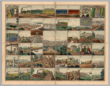
Author
Union Pacific Railroad Game
Full Title
The Voyage from New York to San Francisco upon the Union Pacific Railroad. El Viage De Nueva York A San Francisco Sobre el ferro-carril pacifico de los estados unidos. Reise von New-York nach San Francisco auf der Union-Pacific Bahn. Il viaggio di Nuova York a San Francisco sulla strada ferrata pacifica degli stati uniti. De reis van New-York na San-francisco op de Pacific-ijzerbaan van de vereenigte Staaten. Le voyage de New-york a San Francisco sur le chemin de fer pacific des etats unis.
List No
4781.002
Note
The game board. Date and author estimated, not indicated in the printed materials. An unusual board game based on the "new Union Pacific Railroad." The game board shows forty five beautifully executed views of places along the Union Pacific route, starting with "Rail road depot in New York" and ending in "San Francisco, the metropolis of California." Along the way, we have, among others, views of Pittsburgh, Omaha, "surprise by savage Indians," "wild heard of buffalloes," "railroad bridge over the Platte river," Cheyenne, Green River, Humboldt Valley, "Trukee" Valley, Sierra Nevada and Sacramento. The text is titled "Trip from New-York to San Francisco by the Union Pacific Rail Road. A new illustrated Travel-game with 45 stations, 1 dy, 12 cars and 12 numbers charts." The text is written in German and English and explains the game and the views. The cover of the game box (19x24) has a lovely colored litho view of two women joining hands across the American Continent, one representing America and the other Asia. Not in any of the standard game references - rare.
Author
[Whitney-Graham Company, Inc., Southern Railway (U.S.), Funk & Wagnalls Company.]
Full Title
Map of the Southern railway system. 1929. The Southern Railway. 2-29. (to accompany) The blue book of map making : America's map makers. R.W.C. The Whitney-Graham Co. Inc. (insets) Southern Florida. (with) Cuba.
List No
11489.020
Note
Color map of the Southern and Eastern States. Showing state boundaries, cities, towns and roads. Southern Railway single and double tracks in red and tracks operated separately shown in blue. Includes station index and legend.
Author
Booth, Cameron
Full Title
Amtrak Passenger Rail Services
List No
15878.000
|