|
Author
Booth, Cameron
Full Title
Amtrak Passenger Rail Services
List No
15878.000
Author
[Rand McNally, Southern Pacific Lines]
Full Title
4 Scenic Routes to San Francisco.
List No
12422.005
Author
Cram, George Franklin, 1841-1928
Full Title
Map of the United States of America.
List No
14372.291
Note
Map of the United States. Shows political boundaries, cities, railroads, topography, bodies of water, drainage, shorelines and islands. Relief shown with hachures. Includes latitudinal and longitudinal lines. Inset map: Alaska. Colored lithograph. Map is 32 x 49 cm, on double sheet 45 x 67 cm.
Author
Andriveau-Goujon, E. (Eugène), 1832-1897
Full Title
(24) Carte générale des États-Unis et du Mexique comprenant l'Amérique centrale et les Antilles. E. Andriveau-Goujon, éditeur. Paris, Rue du Bac, 4. Nouvelle édition, 1876.
List No
14008.028
Note
Hand-colored, engraved map of the United States, Mexico, Central America and the Antilles, showing railroads and water routes (on double plate with decorative border). Includes legend indicating European colonies (French, English, Dutch, Danish, Spain and Swedish), as well as 4 bar scales. "No. 24" in upper right. With 4 insets: États de l'Amérique Centrale -- Entré de New-York -- Carte des rapports entre l'Europe & l'Amérique -- Petites Antilles et Nord de l'Amérique du Sud.
Author
Colton, G.W. & C.B.
Full Title
Colton's Railroad Map (Intermediate Size) Of The United States. Reduced Fom "Colton's Railroad & Commercial Map of the United States." Published By G.W. And C.B. Colton & Co. 172 William St. New York. Entered .. 1870 by G.W. & C.B. Colton & Co. ... New York. (inset) Plan Of The Western Portion of the United States.
List No
2689.000
Author
Keeler, William J.
Full Title
National Map Of The Territory Of The United States From The Mississippi River To The Pacific Ocean. Made by the authority of the Hon. O.H. Browning Secretary of the Interior. In the Office of the Indian Bureau Chiefly For Government Purposes under the direction of the Hon. N.G. Taylor Commisr. of Indian affairs & Hon. Chas. E. Mix Chief Clerk of the Indian Bureau; Compiled from authorized explorations of Pacific Rail Road Routes, Public Surveys, and other reliable data from the Departments from the Government at Washington, D.C., by W.J. Keeler, Civil Engineer. 1867. N. DuBois Draughtsman. J.F. Gedney, Lithographer, Engraver & Plate Printer, Washington, D.C. Entered ... 1867 by Wm. J. Keeler ... District of Columbia.
List No
4737.002
Author
Keeler, William J.
Full Title
National Map Of The Territory Of The United States From The Mississippi River To The Pacific Ocean. Made by the authority of the Hon. O.H. Browning Secretary of the Interior. In the Office of the Indian Bureau Chiefly For Government Purposes under the direction of the Hon. N.G. Taylor Commisr. of Indian affairs & Hon. Chas. E. Mix Chief Clerk of the Indian Bureau; Compiled from authorized explorations of Pacific Rail Road Routes, Public Surveys, and other reliable data from the Departments from the Government at Washington, D.C., by W.J. Keeler, Civil Engineer. 1867. N. DuBois Draughtsman. J.F. Gedney, Lithographer, Engraver & Plate Printer, Washington, D.C. Entered ... 1867 by Wm. J. Keeler ... District of Columbia.
List No
0397.002
Author
Keeler, William J.
Full Title
National Map Of The Territory Of The United States From The Mississippi River To The Pacific Ocean. Made by the authority of the Hon. O.H. Browning Secretary of the Interior. In the Office of the Indian Bureau Chiefly For Government Purposes under the direction of the Hon. N.G. Taylor Commisr. of Indian affairs & Hon. Chas. E. Mix Chief Clerk of the Indian Bureau; Compiled from authorized explorations of Pacific Rail Road Routes, Public Surveys, and other reliable data from the Departments from the Government at Washington, D.C., by W.J. Keeler, Civil Engineer. 1867. N. DuBois Draughtsman. J.F. Gedney, Lithographer, Engraver & Plate Printer, Washington, D.C. Entered ... 1867 by Wm. J. Keeler ... District of Columbia.
List No
4694.002
Author
[Pershing, John J. (John Joseph), 1860-1948, Geological Survey (U.S.)]
Full Title
Map of France superimposed on that of the United States : Showing relative distances and the extent of railroad systems used by the American Expeditionary Forces. House Doc. No. 626; 66th Cong., 2d Sess. Engraved and printed by the U. S. Geological Survey.
List No
14379.023
Note
Military map of France, overlaid upon the United States in order to show the relative distances between different cities. Features the railroad systems used by the American Expeditionary Forces during World War I. Shows political boundaries, cities, drainage, coastlines and islands. Includes a legend, explanatory notes and two bar scales given in kilometers and miles, as well as a compass rose with north oriented toward top of sheet (for the United States). Colored engraving. Map is 20 x 24 cm, on fold-out sheet 23 x 27 cm.
Author
Rand, McNally & Co.
Full Title
How the Public Domain Has Been Squandered : Map showing the 139,403,026 acres of the peoples land - equal to 871,268 Farms of 160 Acres Each Worth at $2 an acre, $278,806,052, Given By Republican Congresses to Railroad Corporations. This is more land than is contained in New York, New Jersey, Pennsylvania, Ohio, and Indiana.
List No
13665.000
Note
Political broadside map of the United States, 30x40 on sheet 59x42. setting forth the Democratic Party Platform of 1884 and illustrating "Land Grants to Railroads and Wagon Roadsap
Author
Lloyd, James T.
Full Title
NW Sheet Lloyd's American Railroad Map, Showing the Whole Seat of War.
List No
10543.001
Author
Lloyd, James T.
Full Title
NE Sheet Lloyd's American Railroad Map, Showing the Whole Seat of War.
List No
10543.002
Author
Lloyd, James T.
Full Title
SW Sheet Lloyd's American Railroad Map, Showing the Whole Seat of War.
List No
10543.003
Author
Lloyd, James T.
Full Title
SE Sheet Lloyd's American Railroad Map, Showing the Whole Seat of War.
List No
10543.004
Author
Lloyd, James T.
Full Title
(Composite map of) NW, NE, SW, SE Sheets Lloyd's American Railroad Map, Showing the Whole Seat of War
List No
10543.005
Author
Bowers, David
Full Title
Locomotive map of the United States : A collection of representative types and classes. Dedicated to the romance and history of American Railroading. Designed and drawn by David Bowers. Published and copyright 1935 by J.L. Smith Co. Philadelphia, U.S.A.
List No
11607.000
Note
Color map of the United States, surrounded by illustration of various types of locomotives, with name of steam and electric trains, representing the history and progress of American railroad. Shows state boundaries. Includes railroad equipment, compass rose and notes. "The named trains on the map shows the modern movements in steam and electric transportation in the United States."
Author
Santa Fe (Railway).
Full Title
Growth of the Santa Fe (Railway).
List No
12340.000
Author
Lloyd, James T.
Full Title
Lloyd's New Map of the United States, the Canadas and New Brunswick, From the latest Surveys showing every Railroad & Station Finished to June 1864, and the Atlantic and Gulf Coasts.
List No
12387.001
Note
Color. Has a pasted-in sheet which provides a legend relating to map colors and areas of Unioin and Confederate control in the American Civil War as of October 4, 1864. Also includes a note warning customers of a substandard series of maps being sold under the brand "Lloyd's Maps".
Author
New England Railway Publishing Company
Full Title
ABC The Pathfinder Railway Guide Map, Western Section. (insets) Alaska. Yellowstone Park. Philippine Islands. Hawaiian Islands.
List No
9060.000
Author
Rand McNally & Co.
Full Title
Rand McNally & Co.'s new railway guide map. Printed expressly for J. Bride & Co.'s Great American 25 Cent package, 767 and 769 Broadway, New York City. A.W. Barber, Del. Rand McNally & Co. Printers, engravers and electrotypers, 79 Madison Street, Chicago. (with 2 insets). (on verso) Rand McNally & Co.'s sectional map of the Dakota and the Black Hills.
List No
6878.002
Note
Uncolored map with 2 insets: Vicinity of Boston, Map of the Territories and Pacific Coast. Includes illustrations. Relief shown by hachures. This is one of the earliest Rand McNally maps that we have seen. The date of 1873 is determined from the only date on the map, in the inset map of Cincinnati. Uncolored sectional map with 8 insets: New mining map of Utah, St. Louis, Railroads around Baltimore and Washington, Philadelphia, New York and vicinity, Chicago, Railroad around Cincinnati, 1872-3, Denver. Showing boundaries of township, counties, states and territories, and detail diagram of township numbering system. Includes references, illustrations and advertisements. Relief shown by hachures. Prime meridian is Greenwich.
Author
Union Pacific Railroad Game
Full Title
(Cover to) The Voyage from New York to San Francisco upon the Union Pacific Railroad. El Viage De Nueva York A San Francisco Sobre el ferro-carril pacifico de los estados unidos. Reise von New-York nach San Francisco auf der Union-Pacific Bahn. Il viaggio di Nuova York a San Francisco sulla strada ferrata pacifica degli stati uniti. De reis van New-York na San-francisco op de Pacific-ijzerbaan van de vereenigte Staaten. Le voyage de New-york a San Francisco sur le chemin de fer pacific des etats unis.
List No
4781.001
Note
Date and author estimated, not indicated in the printed materials. An unusual board game based on the "new Union Pacific Railroad." The game board shows forty five beautifully executed views of places along the Union Pacific route, starting with "Rail road depot in New York" and ending in "San Francisco, the metropolis of California." Along the way, we have, among others, views of Pittsburgh, Omaha, "surprise by savage Indians," "wild heard of buffalloes," "railroad bridge over the Platte river," Cheyenne, Green River, Humboldt Valley, "Trukee" Valley, Sierra Nevada and Sacramento. The text is titled "Trip from New-York to San Francisco by the Union Pacific Rail Road. A new illustrated Travel-game with 45 stations, 1 dy, 12 cars and 12 numbers charts." The text is written in German and English and explains the game and the views. The cover of the game box (19x24) has a lovely colored litho view of two women joining hands across the American Continent, one representing America and the other Asia. Not in any of the standard game references - rare.
Author
Union Pacific Railroad Game
Full Title
The Voyage from New York to San Francisco upon the Union Pacific Railroad. El Viage De Nueva York A San Francisco Sobre el ferro-carril pacifico de los estados unidos. Reise von New-York nach San Francisco auf der Union-Pacific Bahn. Il viaggio di Nuova York a San Francisco sulla strada ferrata pacifica degli stati uniti. De reis van New-York na San-francisco op de Pacific-ijzerbaan van de vereenigte Staaten. Le voyage de New-york a San Francisco sur le chemin de fer pacific des etats unis.
List No
4781.002
Note
The game board. Date and author estimated, not indicated in the printed materials. An unusual board game based on the "new Union Pacific Railroad." The game board shows forty five beautifully executed views of places along the Union Pacific route, starting with "Rail road depot in New York" and ending in "San Francisco, the metropolis of California." Along the way, we have, among others, views of Pittsburgh, Omaha, "surprise by savage Indians," "wild heard of buffalloes," "railroad bridge over the Platte river," Cheyenne, Green River, Humboldt Valley, "Trukee" Valley, Sierra Nevada and Sacramento. The text is titled "Trip from New-York to San Francisco by the Union Pacific Rail Road. A new illustrated Travel-game with 45 stations, 1 dy, 12 cars and 12 numbers charts." The text is written in German and English and explains the game and the views. The cover of the game box (19x24) has a lovely colored litho view of two women joining hands across the American Continent, one representing America and the other Asia. Not in any of the standard game references - rare.
Author
Rand McNally and Company
Full Title
(Composite Map of) Rand, McNally & Co.'s New Shippers' Railroad Map of the United States. Scale: 8 miles to one inch. Showing all railroads, each in a separate color, and all railroad stations in large, plain type. This is the El Paso section only, of the above named map. (Below the neatline) Rand, McNally & Co.'s New Shippers' Railroad Map of the United States, Copyright, 1888 by Rand, McNally & Co. Copyright, 1891 by Rand, McNally & Co.
List No
5802.017
Note
This is a composite of all 13 maps. The owner of the 13 maps did not include the 2 western maps in this group for some reason, roughly Dakota and Indian Territory, or they may have been lost over time. Each set of these maps was made to order custom by Rand McNally so it is possible that these 13 maps comprise the entire set. The other 2 maps of the western US to the pacific are in the set but they are at a smaller scale so they are not in this composite image.
Author
Tanner, Henry S.
Full Title
(Title Page to) A Connected View of The Whole Internal Navigation of the United States; ... Corrected and Improved From the Edition of 1826, And Much Enlarged, ... With A Sheet Map, ... The Map Has Been Engraved For the Purpose ... On A Reduced Scale, From Tanner's Excellent Four Sheet Map of the United States, Recently Published. ... By a Citizen of the United States. Philadelphia: Published by the Author ... Printed by Lydia R. Bailey. 1830. (on verso) ...on the seventeenth day of April ... 1830, George Armroyd ... hath deposited ... a Book ... Pennsylvania.
List No
3067A
Author
Tanner, Henry S.
Full Title
A Connected View of The Whole Internal Navigation of the United States; ... Corrected and Improved From the Edition of 1826, And Much Enlarged, ... With A Sheet Map, ... The Map Has Been Engraved For the Purpose ... On A Reduced Scale, From Tanner's Excellent Four Sheet Map of the United States, Recently Published. ... By a Citizen of the United States. Philadelphia: Published by the Author ... Printed by Lydia R. Bailey. 1830. (on verso) ...on the seventeenth day of April ... 1830, George Armroyd ... hath deposited ... a Book ... Pennsylvania.
List No
3067.001
Note
2nd (and best) edition, first with Tanner's Map of the Canals and Railroads of the United States. The map is copyright 1830. The book lists over 150 canals and navigation improvements in great detail. The map shows the most important canals and two railroads in operation, and one proposed railroad (the Great Western Railroad, from New York to the Mississippi River)plus two others. The canals and railroad lines are in color. The first edition appeared in 1826 with 10 maps but without the Tanner map (see our copy #4214). Tanner in 1834 and 1840 (see our copies, #2655 and #979) published a book on Canals and Railroads that uses the same map, updated. Modelski lists the 1834 Tanner map as "one of the earliest general maps of the eastern United States showing railroads in operation." Since this 1830 copy is an earlier state of the same map, it probably qualifies as the true "first." Two folding plates of profiles of canals and railroads at the back. Not in Streeter, Eberstadt, or Graff. Bound in half leather boards with "A Connected View" on the spine.
Author
Houston And Texas Central Railway
Full Title
Texas and Mexico showing Houston and Texas Central system of railways. Rand, McNally & Co, Engr's, Chicago. (inset) Map of United States and Mexico reduced scale; showing the Houston and Texas Central Railway and connections. (1885)
List No
5237.001
Note
Col. map. Includes statistical table: Counties traversed by the Houston & Texas Central Railway
Author
Andreas, A. T. (Alfred Theodore), 1839-1900
Full Title
New railroad map of the United States, the Dominion of Canada, Mexico and the West Indies. (Published by the Andreas Atlas Co., Lakeside Building, Chicago, Ills. Engraved & printed by Chas. Shober & Co., Props. of Chicago Lithographing Co.)
List No
0018.012
Note
Hand col. lithographed map. Relief shown by hachures. Title includes view. Prime meridians: Washington and Greenwich.
Author
[Andreas, A. T. (Alfred Theodore), 1839-1900, Baskin, Forster and Company]
Full Title
New railroad map of the United States and Dominion of Canada. (Published by Baskin, Forster & Co. Lakeside Building Chicago, Ills. 1876. Engraved & Printed by Chas. Shober & Co. Props. of Chicago Lithographing Co.)
List No
0019.006
Note
Lithographed map. Hand col. Relief shown by hachures. Includes farm scene below title.
Author
Breese, Sidney
Full Title
(Title Page to) Reports of Committees, Printed by Order of the Senate of the United States, during the Second Session of the Thirtieth Congress, begun and held at the City of Washington, December 4, 1848 ... Containing Reports from No. 244 to No. 331. Washington: 1849. Accompanied with Skeleton Map Showing the Railroads completed and in Progress in the United States, and those projected through the Public Lands and their connection with the principal Harbours on the Lakes and on the Seaboard. Printed by order of the Senate of the United States the 9th Sess: 31st Congress 1848-9.
List No
0091.001
Note
Very early U.S. Gov't Railroad Map. With proposed and existing railway lines in color. Bound with the "Reports of Committees, Printed by Order of the Senate of the United States, during the Second Session of the Thirtieth Congress, begun and held at the City of Washington, December 4, 1848 ... Containing Reports from No. 244 to No. 331. Washington: 1849." In full leather covers 23x15 with "Senate Reports 2d S. 30th C." on spine.
Author
Breese, Sidney
Full Title
(Text Page to) Report: In Senate of the United States. December 19, 1848 ... Mr. Breese made the following Report (to accompany bill S. No. 355.) 30 Congress, 2nd Session, Rep. Com., No. 244. (at head of title) Senate. (to accompany) Reports of Committees, Printed by Order of the Senate of the United States, during the Second Session of the Thirtieth Congress, begun and held at the City of Washington, December 4, 1848 ... Containing Reports from No. 244 to No. 331. Washington: 1849. Accompanied with Skeleton Map Showing the Railroads completed and in Progress in the United States, and those projected through the Public Lands and their connection with the principal Harbours on the Lakes and on the Seaboard. Printed by order of the Senate of the United States the 9th Sess: 31st Congress 1848-9.
List No
0091.002
Note
Very early U.S. Gov't Railroad Map. With proposed and existing railway lines in color. Bound with the "Reports of Committees, Printed by Order of the Senate of the United States, during the Second Session of the Thirtieth Congress, begun and held at the City of Washington, December 4, 1848 ... Containing Reports from No. 244 to No. 331. Washington: 1849." In full leather covers 23x15 with "Senate Reports 2d S. 30th C." on spine.
Author
Breese, Sidney
Full Title
(Text Page to) Report: In Senate of the United States. December 19, 1848 ... Mr. Breese made the following Report (to accompany bill S. No. 355.) 30 Congress, 2nd Session, Rep. Com., No. 244. (at head of title) Senate. (to accompany) Reports of Committees, Printed by Order of the Senate of the United States, during the Second Session of the Thirtieth Congress, begun and held at the City of Washington, December 4, 1848 ... Containing Reports from No. 244 to No. 331. Washington: 1849. Accompanied with Skeleton Map Showing the Railroads completed and in Progress in the United States, and those projected through the Public Lands and their connection with the principal Harbours on the Lakes and on the Seaboard. Printed by order of the Senate of the United States the 9th Sess: 31st Congress 1848-9.
List No
0091.003
Note
Very early U.S. Gov't Railroad Map. With proposed and existing railway lines in color. Bound with the "Reports of Committees, Printed by Order of the Senate of the United States, during the Second Session of the Thirtieth Congress, begun and held at the City of Washington, December 4, 1848 ... Containing Reports from No. 244 to No. 331. Washington: 1849." In full leather covers 23x15 with "Senate Reports 2d S. 30th C." on spine.
Author
Breese, Sidney
Full Title
(Text Page to) Report: In Senate of the United States. December 19, 1848 ... Mr. Breese made the following Report (to accompany bill S. No. 355.) 30 Congress, 2nd Session, Rep. Com., No. 244. (at head of title) Senate. (to accompany) Reports of Committees, Printed by Order of the Senate of the United States, during the Second Session of the Thirtieth Congress, begun and held at the City of Washington, December 4, 1848 ... Containing Reports from No. 244 to No. 331. Washington: 1849. Accompanied with Skeleton Map Showing the Railroads completed and in Progress in the United States, and those projected through the Public Lands and their connection with the principal Harbours on the Lakes and on the Seaboard. Printed by order of the Senate of the United States the 9th Sess: 31st Congress 1848-9.
List No
0091.004
Note
Very early U.S. Gov't Railroad Map. With proposed and existing railway lines in color. Bound with the "Reports of Committees, Printed by Order of the Senate of the United States, during the Second Session of the Thirtieth Congress, begun and held at the City of Washington, December 4, 1848 ... Containing Reports from No. 244 to No. 331. Washington: 1849." In full leather covers 23x15 with "Senate Reports 2d S. 30th C." on spine.
Author
Breese, Sidney
Full Title
(Text Page to) Report: In Senate of the United States. December 19, 1848 ... Mr. Breese made the following Report (to accompany bill S. No. 355.) 30 Congress, 2nd Session, Rep. Com., No. 244. (at head of title) Senate. (to accompany) Reports of Committees, Printed by Order of the Senate of the United States, during the Second Session of the Thirtieth Congress, begun and held at the City of Washington, December 4, 1848 ... Containing Reports from No. 244 to No. 331. Washington: 1849. Accompanied with Skeleton Map Showing the Railroads completed and in Progress in the United States, and those projected through the Public Lands and their connection with the principal Harbours on the Lakes and on the Seaboard. Printed by order of the Senate of the United States the 9th Sess: 31st Congress 1848-9.
List No
0091.005
Note
Very early U.S. Gov't Railroad Map. With proposed and existing railway lines in color. Bound with the "Reports of Committees, Printed by Order of the Senate of the United States, during the Second Session of the Thirtieth Congress, begun and held at the City of Washington, December 4, 1848 ... Containing Reports from No. 244 to No. 331. Washington: 1849." In full leather covers 23x15 with "Senate Reports 2d S. 30th C." on spine.
Author
Breese, Sidney
Full Title
(Text Page to) Report: In Senate of the United States. December 19, 1848 ... Mr. Breese made the following Report (to accompany bill S. No. 355.) 30 Congress, 2nd Session, Rep. Com., No. 244. (at head of title) Senate. (to accompany) Reports of Committees, Printed by Order of the Senate of the United States, during the Second Session of the Thirtieth Congress, begun and held at the City of Washington, December 4, 1848 ... Containing Reports from No. 244 to No. 331. Washington: 1849. Accompanied with Skeleton Map Showing the Railroads completed and in Progress in the United States, and those projected through the Public Lands and their connection with the principal Harbours on the Lakes and on the Seaboard. Printed by order of the Senate of the United States the 9th Sess: 31st Congress 1848-9.
List No
0091.006
Note
Very early U.S. Gov't Railroad Map. With proposed and existing railway lines in color. Bound with the "Reports of Committees, Printed by Order of the Senate of the United States, during the Second Session of the Thirtieth Congress, begun and held at the City of Washington, December 4, 1848 ... Containing Reports from No. 244 to No. 331. Washington: 1849." In full leather covers 23x15 with "Senate Reports 2d S. 30th C." on spine.
Author
Breese, Sidney
Full Title
(Text Page to) Report: In Senate of the United States. December 19, 1848 ... Mr. Breese made the following Report (to accompany bill S. No. 355.) 30 Congress, 2nd Session, Rep. Com., No. 244. (at head of title) Senate. (to accompany) Reports of Committees, Printed by Order of the Senate of the United States, during the Second Session of the Thirtieth Congress, begun and held at the City of Washington, December 4, 1848 ... Containing Reports from No. 244 to No. 331. Washington: 1849. Accompanied with Skeleton Map Showing the Railroads completed and in Progress in the United States, and those projected through the Public Lands and their connection with the principal Harbours on the Lakes and on the Seaboard. Printed by order of the Senate of the United States the 9th Sess: 31st Congress 1848-9.
List No
0091.007
Note
Very early U.S. Gov't Railroad Map. With proposed and existing railway lines in color. Bound with the "Reports of Committees, Printed by Order of the Senate of the United States, during the Second Session of the Thirtieth Congress, begun and held at the City of Washington, December 4, 1848 ... Containing Reports from No. 244 to No. 331. Washington: 1849." In full leather covers 23x15 with "Senate Reports 2d S. 30th C." on spine.
Author
Breese, Sidney
Full Title
(Text Page to) Report: In Senate of the United States. December 19, 1848 ... Mr. Breese made the following Report (to accompany bill S. No. 355.) 30 Congress, 2nd Session, Rep. Com., No. 244. (at head of title) Senate. (to accompany) Reports of Committees, Printed by Order of the Senate of the United States, during the Second Session of the Thirtieth Congress, begun and held at the City of Washington, December 4, 1848 ... Containing Reports from No. 244 to No. 331. Washington: 1849. Accompanied with Skeleton Map Showing the Railroads completed and in Progress in the United States, and those projected through the Public Lands and their connection with the principal Harbours on the Lakes and on the Seaboard. Printed by order of the Senate of the United States the 9th Sess: 31st Congress 1848-9.
List No
0091.008
Note
Very early U.S. Gov't Railroad Map. With proposed and existing railway lines in color. Bound with the "Reports of Committees, Printed by Order of the Senate of the United States, during the Second Session of the Thirtieth Congress, begun and held at the City of Washington, December 4, 1848 ... Containing Reports from No. 244 to No. 331. Washington: 1849." In full leather covers 23x15 with "Senate Reports 2d S. 30th C." on spine.
Author
Breese, Sidney
Full Title
(Text Page to) Report: In Senate of the United States. December 19, 1848 ... Mr. Breese made the following Report (to accompany bill S. No. 355.) 30 Congress, 2nd Session, Rep. Com., No. 244. (at head of title) Senate. (to accompany) Reports of Committees, Printed by Order of the Senate of the United States, during the Second Session of the Thirtieth Congress, begun and held at the City of Washington, December 4, 1848 ... Containing Reports from No. 244 to No. 331. Washington: 1849. Accompanied with Skeleton Map Showing the Railroads completed and in Progress in the United States, and those projected through the Public Lands and their connection with the principal Harbours on the Lakes and on the Seaboard. Printed by order of the Senate of the United States the 9th Sess: 31st Congress 1848-9.
List No
0091.009
Note
Very early U.S. Gov't Railroad Map. With proposed and existing railway lines in color. Bound with the "Reports of Committees, Printed by Order of the Senate of the United States, during the Second Session of the Thirtieth Congress, begun and held at the City of Washington, December 4, 1848 ... Containing Reports from No. 244 to No. 331. Washington: 1849." In full leather covers 23x15 with "Senate Reports 2d S. 30th C." on spine.
Author
Breese, Sidney
Full Title
(Text Page to) Report: In Senate of the United States. December 19, 1848 ... Mr. Breese made the following Report (to accompany bill S. No. 355.) 30 Congress, 2nd Session, Rep. Com., No. 244. (at head of title) Senate. (to accompany) Reports of Committees, Printed by Order of the Senate of the United States, during the Second Session of the Thirtieth Congress, begun and held at the City of Washington, December 4, 1848 ... Containing Reports from No. 244 to No. 331. Washington: 1849. Accompanied with Skeleton Map Showing the Railroads completed and in Progress in the United States, and those projected through the Public Lands and their connection with the principal Harbours on the Lakes and on the Seaboard. Printed by order of the Senate of the United States the 9th Sess: 31st Congress 1848-9.
List No
0091.010
Note
Very early U.S. Gov't Railroad Map. With proposed and existing railway lines in color. Bound with the "Reports of Committees, Printed by Order of the Senate of the United States, during the Second Session of the Thirtieth Congress, begun and held at the City of Washington, December 4, 1848 ... Containing Reports from No. 244 to No. 331. Washington: 1849." In full leather covers 23x15 with "Senate Reports 2d S. 30th C." on spine.
Author
Breese, Sidney
Full Title
Skeleton Map Showing the Railroads completed and in Progress in the United States, and those projected through the Public Lands and their connection with the principal Harbours on the Lakes and on the Seaboard. Printed by order of the Senate of the United States the 9th Sess: 31st Congress 1848-9. Accompanied with a report from Hon. Sidney Breese, for granting land to the State if Illinois to aid in the completion of her rail roads. C.B. Graham's Lithy. Washington City, D.C. (to accompany) Report: In Senate of the United States. December 19, 1848.
List No
0091.011
Note
Very early U.S. Gov't Railroad Map. With proposed and existing railway lines in color. Shows the eastern half of the United States indicating drainage, state boundaries, major cities, and constructed and contemplated railroads. The southern portion of map indicates proposed shipping routes to points in the West Indies and Middle America. Includes table showing the time by the shortest railroad route, and the average time by steam boat route. Bound with the "Reports of Committees, Printed by Order of the Senate of the United States, during the Second Session of the Thirtieth Congress, begun and held at the City of Washington, December 4, 1848.
Author
Canada Government Railways
Full Title
(Covers to) Map Shewing the Railways of Canada to Accompany Annual Report on Railway Statistics. 1886. Collingwood Schreiber, Chief Engineer and General Manager of Government Railways. Office Of The Chief Engineer And General Manager Of Government Railways. Compiled by E.V. Johnson, M.C.S.C.E., In charge of Draughting Offices. Drawn by A.M. Edmonds. The Burland Lithographic Co. Montreal. (seal) Department Of Railways And Canals Canada. (in red) Railways Of Canada. In Operation And Under Construction. 31st December, 1886 ...
List No
0121A
Note
Accompanies the Annual Report on Railway Statistics. With full printed color, the railways shown in red. The map is in two sheets, each dissected into 54 sections. The map sheets are folding with marbled end sheets and a brown cloth slip case 21x14 with a label reading "Canadian Dominion. London: Edward Stanford, Wholesale & Retail Mapseller, &c. 55, Charing Cross. Schreiber ..."
Author
Canada Government Railways
Full Title
Map Shewing the Railways of Canada to Accompany Annual Report on Railway Statistics. 1886. Collingwood Schreiber, Chief Engineer and General Manager of Government Railways. Office Of The Chief Engineer And General Manager Of Government Railways. Compiled by E.V. Johnson, M.C.S.C.E., In charge of Draughting Offices. Drawn by A.M. Edmonds. The Burland Lithographic Co. Montreal. (seal) Department Of Railways And Canals Canada. (in red) Railways Of Canada. In Operation And Under Construction. 31st December, 1886 ...
List No
0121.001
Note
Accompanies the Annual Report on Railway Statistics. With full printed color, the railways shown in red. The map is in two sheets, each dissected into 54 sections. The map sheets are folding with marbled end sheets and a brown cloth slip case 21x14 with a label reading "Canadian Dominion. London: Edward Stanford, Wholesale & Retail Mapseller, &c. 55, Charing Cross. Schreiber ..."
Author
Colton, G.W. & C.B.
Full Title
(Covers to) Colton's Railroad & Commercial Atlas Of The United States, Canada Etc. Map No. 5. Michigan, Wisconsin & Minnesota. Published by G.W. & C.B. Colton. & Co. New York, 1869.
List No
0160.001
Note
This map is one of several pocket maps that Colton published as a "Railroad & Commercial Atlas of the United States..." These are probably descendants of an earlier series on the same scale that Colton published for H.V. Poor in 1860 - see Modelski North America plate 28 and Modelski 111 and 121. See also our #3940. These must have been among the largest scale regional railroad maps of the period. Full color by county, folded into stamped dark brown cloth covers 16x10 with "G. Woolworth Colton's County & Distance Railroad Map of Michigan, Wisconsin, & Minnesota. Showing every Station &c" in gilt. Prime meridians are Greenwich and Washington D.C.
Author
Colton, G.W. & C.B.
Full Title
Colton's Railroad & Commercial Atlas Of The United States, Canada Etc. Map No. 5. Michigan, Wisconsin & Minnesota. Published by G.W. & C.B. Colton. & Co. New York, 1869.
List No
0160.002
Note
This map is one of several pocket maps that Colton published as a "Railroad & Commercial Atlas of the United States..." These are probably descendants of an earlier series on the same scale that Colton published for H.V. Poor in 1860 - see Modelski North America plate 28 and Modelski 111 and 121. See also our #3940. These must have been among the largest scale regional railroad maps of the period. Full color by county, folded into stamped dark brown cloth covers 16x10 with "G. Woolworth Colton's County & Distance Railroad Map of Michigan, Wisconsin, & Minnesota. Showing every Station &c" in gilt. Prime meridians are Greenwich and Washington D.C.
Author
Colton, G.W. & C.B.
Full Title
(Covers to) Colton's New Rail Road & County Map Of The United States, The Canadas &c. 1871. Published By G.W. And C.B. Colton, 172 William St. New York. Entered ... 1869 by G.W. & C.B. Colton & Co ... New York. (inset) Colton's Map Of The United States showing the Proposed Railroad Routes To The Pacific Ocean. (inset) Southern Part Of Florida.
List No
0163.001
Note
This is a later version of our #4812, with the map extended west to the 106th meridian, and the first tier of eastern counties in Dakota shown, along with further county development in Nebraska and Kansas. Folded into stamped dark brown cloth covers 15.5x10 with "Colton's Rail Road And County Map Of The United States Canadas &c. G.W. & C.B. Colton. New York." in gilt. Full color by county. Prime meridians are Greenwich and Washington D.C.
Author
Colton, G.W. & C.B.
Full Title
(Covers to) Colton's New Rail Road & County Map Of The United States, The Canadas &c. 1871. Published By G.W. And C.B. Colton, 172 William St. New York. Entered ... 1869 by G.W. & C.B. Colton & Co ... New York. (inset) Colton's Map Of The United States showing the Proposed Railroad Routes To The Pacific Ocean. (inset) Southern Part Of Florida.
List No
0163.002
Note
This is a later version of our #4812, with the map extended west to the 106th meridian, and the first tier of eastern counties in Dakota shown, along with further county development in Nebraska and Kansas. Folded into stamped dark brown cloth covers 15.5x10 with "Colton's Rail Road And County Map Of The United States Canadas &c. G.W. & C.B. Colton. New York." in gilt. Full color by county. Prime meridians are Greenwich and Washington D.C.
Author
Leahy, J.F.
Full Title
(Covers to) Leahy's Hotel Guide and Railway Distance Maps of America. The Green book, It Shows the Way. Published by American Hotel Register Company. Leahy Building 228-234 W. Ontario street, Chicago, Ill. Established Nearly Half a Century. Established Nearly Half Century. Revised Edition No. 59, Copyrighted Jan. 1934. Price of this book complete $5.00. Subscription, Five Years .... $20.00, Combined Guide and Map of any Individual State 25 cents.
List No
0425.001
Note
A guide to accompany the revised edition No. 59 of Leahy's Hotel Guide and Railway Distance Maps of America. It lists the Hotels of the town with the number of rooms of each, their rates per day and the population of the town. It includes the name of the railroads entering the town and where the town can be found on the map. Maps of each state are opposite the State lists of towns and hotels making it easy and convenient to refer from the one to the other. The maps give the railroad distance between towns. The Guide includes the Provinces of Canada, as well as the United States. The railroad distance maps of Europe, Mexico, South and Central America ... Maps printed without color, Railroad lines shown in red on some maps. The Guidebook is bound in Green paper covers with title in gold: Leahy's Hotel Guide and R.R. Distance Maps. Southern Pacific Lines.
Author
Leahy, J.F.
Full Title
Leahy's Railway Distance Map of the United States. Published by American Hotel Register Company. Leahy Building 228-234 W. Ontario street, Chicago. (Copyrighted).
List No
0425.002
Note
Map printed without color. The railway lines shown in red and back. All lines represent the train routes and the mileage between points.
Author
Leahy, J.F.
Full Title
Leahy's Railway Distance Map of the United States. Published by American Hotel Register Company. Leahy Building 228-234 W. Ontario street, Chicago. (Copyrighted).
List No
0425.003
Note
Map printed without color. Showing the Eastern States. The railway lines shown in red and back. All lines represent the train routes and the mileage between points.
Author
Leahy, J.F.
Full Title
Leahy's Railway Distance Map of the United States. Published by American Hotel Register Company. Leahy Building 228-234 W. Ontario street, Chicago. (Copyrighted).
List No
0425.004
Note
Map printed without color. The railway lines shown in red and back. All lines represent the train routes and the mileage between points.
Author
Leahy, J.F.
Full Title
(Title Page to) Leahy's Hotel Guide and Railway Distance Maps of America. The Green book, It Shows the Way. Published by American Hotel Register Company. Leahy Building 228-234 W. Ontario street, Chicago, Ill. Established Nearly Half Century. Revised Edition No. 59, Copyrighted Jan. 1934. Price of this book, complete $5.00. Subscription, Five Years .... $20.00, Combined Guide and Map of any Individual State 25 cents.
List No
0425.005
Note
A guide to accompany the revised edition No. 59 of Leahy's Hotel Guide and Railway Distance Maps of America. It lists the Hotels of the town with the number of rooms of each, their rates per day and the population of the town. It includes the name of the railroads entering the town and where the town can be found on the map. Maps of each state are opposite the State lists of towns and hotels making it easy and convenient to refer from the one to the other. The maps give the railroad distance between towns. The Guide includes Index, explanation of Hotel listing, and explanatory map, the Provinces of Canada, as well as the United States. The railroad distance maps of Europe, Mexico, South and Central America ... Maps printed without color, Railroad lines shown in red on some maps. The Guidebook is bound in Green paper covers with title in gold: Leahy's Hotel Guide and R.R. Distance Maps. Southern Pacific Lines.
Author
Leahy, J.F.
Full Title
Chart of Distances Between Important Cities of the United States.
List No
0425.147
Note
Table of distances "compiled from the war Department's Official table of distances, and other reliable sources."
Author
Leahy, J.F.
Full Title
Leahy's Railway Distance Map of the United States. Published by American Hotel Register Company. Leahy Building 228-234 W. Ontario street, Chicago. (Copyrighted).
List No
0425.148
Note
Map printed without color. The railway lines shown in red and back. All lines represent the train routes and the mileage between points.
Author
Leahy, J.F.
Full Title
Leahy's Railway Distance Map of the United States. Published by American Hotel Register Company. Leahy Building 228-234 W. Ontario street, Chicago. (Copyrighted).
List No
0425.149
Note
Map printed without color. The railway lines shown in red and back. All lines represent the train routes and the mileage between points.
Author
Leahy, J.F.
Full Title
Leahy's Railway Distance Map of the United States. Published by American Hotel Register Company. Leahy Building 228-234 W. Ontario street, Chicago. (Copyrighted).
List No
0425.150
Note
Map printed without color. The railway lines shown in red and back. All lines represent the train routes and the mileage between points.
Author
Lizars, William Home, 1788-1859
Full Title
United States & Texas. With all the railways and canals. Published by W. Lizars, Edinburgh. (to accompany) Lizars' Edinburgh Geographical General Atlas ... 1841.
List No
0438.074
Note
Double page engraved hand colored in outline. Relief shown by hachures. Shows "Republic of Texas," the eastern United States and its western territories, Indian settlements, towns, roads, railroads, rivers, canals and mountains. Prime meridian is Greenwich.
Author
Mitchell, Samuel Augustus
Full Title
(Covers to) Mitchell's Compendium Of The Internal Improvements Of The United States; Comprising General Notices Of All The Most Important Canals and Rail-Roads... Philadelphia: Published By Mitchell & Hinman, No. 6, North-Fifth Street. 1838. (on verso) Entered ... 1835, by Mitchell & Hinman ... Pennsylvania. Stereotyped by John Fagan ... Philadelphia. (with) Mitchell's Map Of The United States Showing the Principal Travelling, Turnpike and Common Roads ... Philadelphia: Published By S. Augustus Mitchell. 1838. Sold by Mitchell & Hinman. No. 6 North Fifth Street. Entered ... 1835, by S. Augustus Mitchell... Pennsylvania. (with 8 inset maps).
List No
0521.001
Note
The second edition. No obvious changes noted from the 1835 edition of the map. Full color. 84 Page book is bound into patterned teal blue cloth covers with "The American Traveller, And Guide Through The United States." on cover label. Four page catalogue of Mitchell's maps.
Author
Mitchell, Samuel Augustus
Full Title
(Title Page to) Mitchell's Compendium Of The Internal Improvements Of The United States; Comprising General Notices Of All The Most Important Canals and Rail-Roads... Philadelphia: Published By Mitchell & Hinman, No. 6, North-Fifth Street. 1838. (on verso) Entered ... 1835, by Mitchell & Hinman ... Pennsylvania. Stereotyped by John Fagan ... Philadelphia. (with) Mitchell's Map Of The United States Showing the Principal Travelling, Turnpike and Common Roads ... Philadelphia: Published By S. Augustus Mitchell. 1838. Sold by Mitchell & Hinman. No. 6 North Fifth Street. Entered ... 1835, by S. Augustus Mitchell... Pennsylvania. (with 8 inset maps).
List No
0521.002
Note
The second edition. No obvious changes noted from the 1835 edition of the map. Full color. 84 Page book is bound into patterned teal blue cloth covers with "The American Traveller, And Guide Through The United States." on cover label. Four page catalogue of Mitchell's maps.
Author
Mitchell, Samuel Augustus
Full Title
Mitchell's Map Of The United States Showing the Principal Travelling, Turnpike and Common Roads ... Philadelphia: Published By S. Augustus Mitchell. 1838. Sold by Mitchell & Hinman. No. 6 North Fifth Street. Entered ... 1835, by S. Augustus Mitchell... Pennsylvania. (with 8 inset maps. (with) Mitchell's Compendium Of The Internal Improvements Of The United States; Comprising General Notices Of All The Most Important Canals and Rail-Roads... Philadelphia: Published By Mitchell & Hinman, No. 6, North-Fifth Street. 1838. (on verso) Entered ... 1835, by Mitchell & Hinman ... Pennsylvania. Stereotyped by John Fagan ... Philadelphia.
List No
0521.003
Note
The second edition. No obvious changes noted from the 1835 edition of the map. Full color. 84 Page book is bound into patterned teal blue cloth covers with "The American Traveller, And Guide Through The United States." on cover label. Four page catalogue of Mitchell's maps.
Author
Mitchell, Samuel Augustus Jr.
Full Title
Railroad map of the United States, showing the through lines of communication from the Atlantic to the Pacific, together with the various steamship lines along the seaboard. Copyright by Wm. M. Bradley & Bro. 1884.
List No
0592.010
Note
Red printed colored lines. Relief shown by hachures. Shows settlements, rivers, named railroads and steamship lines, etc. Prime meridians: Greenwich and Washington.
Full Title
Railroad map of the United States, showing the through lines of communication from the Atlantic to the Pacific, together with the various steamship lines along the seaboard. Copyright 1886 by Wm. M. Bradley & Bro. (1890)
List No
0594.009
Note
Colored map. Relief shown by hachures. Shows settlements, rivers, named railroads and steamship lines, etc. Prime meridians: Greenwich and Washington.
Author
[Pacific Railroad Survey, Warren, Gouverneur Kemble, 1830-1882]
Full Title
(Covers to) Reports of Explorations and Surveys, to Ascertain the Most Practicable and Economical Route for a Railroad From the Mississippi River to the Pacific Ocean. Made Under the Direction of the Secretary of War, In 1853-56, According to Acts of Congress of March 3, 1853, May 31, 1854, and August 5, 1854. Volume XI. Washington: George W. Bowman, Printer. 1861. 36th Congress, 2d Session, Senate, Ex. Doc.
List No
0693A
Author
[Pacific Railroad Survey, Warren, Gouverneur Kemble, 1830-1882]
Full Title
(Title Page to) Reports of Explorations and Surveys, to Ascertain the Most Practicable and Economical Route for a Railroad From the Mississippi River to the Pacific Ocean. Made Under the Direction of the Secretary of War, In 1853-56, According to Acts of Congress of March 3, 1853, May 31, 1854, and August 5, 1854. Volume XI. Washington: George W. Bowman, Printer. 1861. 36th Congress, 2d Session, Senate, Ex. Doc.
List No
0693B
Note
This Quarto issue of the report is the House issue, except for volume XI which is the Senate issue. W. Heckrotte has an unusual copy of the Warren U.S. map found in this report. It is dissected on linen and is an earlier version of the map published with the Quarto report. It has 40 authorities vs. 42 in the quarto issue map, shorter note to left of authorities, lots of plate differences, especially: nothing in Owyhee area, differences in N.M., Calif., etc. Looks like someone asked for the map before it was finished -see the Lack of ocean lines in the top half south of Gray's Harbor. In 13 volumes. Bound in full leather with "Explorations and Surveys for a Railroad to the Pacific Ocean" and the volume number on the spine in gold.
Author
[Pacific Railroad Survey, Warren, Gouverneur Kemble, 1830-1882]
Full Title
(Contents Page to) Reports of Explorations and Surveys, to Ascertain the Most Practicable and Economical Route for a Railroad From the Mississippi River to the Pacific Ocean. Made Under the Direction of the Secretary of War, In 1853-56, According to Acts of Congress of March 3, 1853, May 31, 1854, and August 5, 1854. Volume XI. Washington: George W. Bowman, Printer. 1861. 36th Congress, 2d Session, Senate, Ex. Doc.
List No
0693C
Note
"Contents of volume XI."
Author
[Pacific Railroad Survey, Warren, Gouverneur Kemble, 1830-1882]
Full Title
(Title Page to) Memoir to accompany the Map of the territory of the United States from the Mississippi River to the Pacific Ocean, giving a brief account of each of the exploring expeditions since A.D. 1800, with a detailed description of the method adopted in compiling the general map. By Lieut. Gouverneur K. Warren, Corps of Topographical Engineers, U.S.A. 1859.
List No
0693D
Author
[Pacific Railroad Survey, Warren, Gouverneur Kemble, 1830-1882]
Full Title
(Contents Page to) Memoir to accompany the Map of the territory of the United States from the Mississippi River to the Pacific Ocean, giving a brief account of each of the exploring expeditions since A.D. 1800, with a detailed description of the method adopted in compiling the general map. By Lieut. Gouverneur K. Warren, Corps of Topographical Engineers, U.S.A. 1859.
List No
0693E
Note
"List of illustrations."
Author
[Pacific Railroad Survey, Warren, Gouverneur Kemble, 1830-1882]
Full Title
(Title Page to) Topographical maps, profiles, and sketches to illustrate the various Reports of Surveys for railroad routes from the Mississippi River to the Pacific Ocean. Washington, D.C., 1861.
List No
0693F
Author
[Pacific Railroad Survey, Warren, Gouverneur Kemble, 1830-1882]
Full Title
(Contents Page to) Topographical maps, profiles, and sketches to illustrate the various Reports of Surveys for railroad routes from the Mississippi River to the Pacific Ocean. Washington, D.C., 1861.
List No
0693G
Author
[Pacific Railroad Survey, Warren, Gouverneur Kemble, 1830-1882]
Full Title
(Contents Page to) Topographical maps, profiles, and sketches to illustrate the various Reports of Surveys for railroad routes from the Mississippi River to the Pacific Ocean. Washington, D.C., 1861.
List No
0693H
Author
[Abbot, Henry L., Humphreys, A.A., Warren, Gouverneur Kemble, 1830-1882]
Full Title
Profiles of the main routes surveyed, compiled in 1855, by Lieutenants G.K. Warren & H.L. Abbot, Corps Topl. Engineers; with revisions and additional compilations from the results of subsequent examinations and surveys. Prepared in the Office of Pacific Rail Road Explorations and Surveys. Captain A.A. Humphreys, Corps Topl. Engineers, in charge, by direction of Hon. Jefferson Davis, Secretary of War. 1856. Explorations and Surveys for the Rail Road Routes from the Mississippi River to the Pacific Ocean, War Department. (with) Profiles of rail roads constructed across the Alleghany mountains.
List No
0693.019
Note
Uncolored map profiles with inset profile. Printed on 2 sheets; joined as 1.
Author
Rand McNally and Company
Full Title
The Rand-McNally Official Railway Guide Map. Corrected To November 1st, 1877. (inset) Vicinity Of Boston. (inset) Vicinity Of New York And Philadelphia. (on verso) Rand-McNally Official Railway Guide Map of the Territories and the Pacific Coast.
List No
0748.001
Note
Full color by state.; Western states shown on verso without color. Advertisements, and "Table of comparison, showing the difference in time of different localities." on verso. Relief shown by hachures. Prime meridian is Greenwich.
Author
Rand McNally and Company
Full Title
Rand-McNally Official Railway Guide Map of the Territories and the Pacific Coast. (on verso)The Rand-McNally Official Railway Guide Map. Corrected To November 1st, 1877. (inset) Vicinity Of Boston. (inset) Vicinity Of New York And Philadelphia.
List No
0748.002
Note
Uncolored map of Western states.; Eastern states shown on verso in full color by state. Includes advertisements, and "Table of comparison, showing the difference in time of different localities." Relief shown by hachures. Prime meridian is Greenwich.
Author
Rand McNally and Company
Full Title
(Covers to) United States. Rand, McNally & Co., Map Publishers and Engravers, Chicago, 1898. Rand, McNally & Co.'s New Business Atlas Map of the United States. Copyright, 1895, by Rand, McNally & Co. (inset) Alaska. (on verso) Chicago To Denver. Rand, McNally & Co.'s New Commercial Railroad Map of the United States. Copyright, 1898, ... 1896 ... (with) East of Chicago ... (with 2 inset maps). (on verso) Denver To Pacific Coast ...
List No
0772.001
Note
Four full printed color maps from large U.S. Commercial Map. Folded into brown card board covers 17x11 printed with "Rand-McNally New Commercial Map Of The United States In Section. East Of Chicago. Chicago To Denver. Denver To Pacific Coast. United States In One Map. Rand, McNally & Co., Publishers, Chicago And New York." Prime meridian is Greenwich, Relief shown by hachures.
Author
Rand McNally and Company
Full Title
United States. Rand, McNally & Co., Map Publishers and Engravers, Chicago, 1898. Rand, McNally & Co.'s New Business Atlas Map of the United States. Copyright, 1895, by Rand, McNally & Co. (inset) Alaska. (on verso) Chicago To Denver. Rand, McNally & Co.'s New Commercial Railroad Map of the United States. Copyright, 1898, ... 1896 ... (with) East of Chicago ... (with 2 inset maps). (on verso) Denver To Pacific Coast ...
List No
0772.002
Note
Four full printed color maps from large U.S. Commercial Map. Folded into brown card board covers 17x11 printed with "Rand-McNally New Commercial Map Of The United States In Section. East Of Chicago. Chicago To Denver. Denver To Pacific Coast. United States In One Map. Rand, McNally & Co., Publishers, Chicago And New York." Prime meridian is Greenwich, Relief shown by hachures.
Author
Rand McNally and Company
Full Title
United States. Rand, McNally & Co., Map Publishers and Engravers, Chicago, 1898. Rand, McNally & Co.'s New Business Atlas Map of the United States. Copyright, 1895, by Rand, McNally & Co. (inset) Alaska. (on verso) Chicago To Denver. Rand, McNally & Co.'s New Commercial Railroad Map of the United States. Copyright, 1898, ... 1896 ... (with) East of Chicago ... (with 2 inset maps). (on verso) Denver To Pacific Coast ...
List No
0772.003
Note
Four full printed color maps from large U.S. Commercial Map. Folded into brown card board covers 17x11 printed with "Rand-McNally New Commercial Map Of The United States In Section. East Of Chicago. Chicago To Denver. Denver To Pacific Coast. United States In One Map. Rand, McNally & Co., Publishers, Chicago And New York." Prime meridian is Greenwich, Relief shown by hachures.
Author
Rand McNally and Company
Full Title
United States. Rand, McNally & Co., Map Publishers and Engravers, Chicago, 1898. Rand, McNally & Co.'s New Business Atlas Map of the United States. Copyright, 1895, by Rand, McNally & Co. (inset) Alaska. (on verso) Chicago To Denver. Rand, McNally & Co.'s New Commercial Railroad Map of the United States. Copyright, 1898, ... 1896 ... (with) East of Chicago ... (with 2 inset maps). (on verso) Denver To Pacific Coast ...
List No
0772.004
Note
Four full printed color maps from large U.S. Commercial Map. Folded into brown card board covers 17x11 printed with "Rand-McNally New Commercial Map Of The United States In Section. East Of Chicago. Chicago To Denver. Denver To Pacific Coast. United States In One Map. Rand, McNally & Co., Publishers, Chicago And New York." Prime meridian is Greenwich, Relief shown by hachures.
Author
Rand McNally and Company
Full Title
United States. Rand, McNally & Co., Map Publishers and Engravers, Chicago, 1898. Rand, McNally & Co.'s New Business Atlas Map of the United States. Copyright, 1895, by Rand, McNally & Co. (inset) Alaska. (on verso) Chicago To Denver. Rand, McNally & Co.'s New Commercial Railroad Map of the United States. Copyright, 1898, ... 1896 ... (with) East of Chicago ... (with 2 inset maps). (on verso) Denver To Pacific Coast ...
List No
0772.005
Note
Four full printed color maps from large U.S. Commercial Map. Folded into brown card board covers 17x11 printed with "Rand-McNally New Commercial Map Of The United States In Section. East Of Chicago. Chicago To Denver. Denver To Pacific Coast. United States In One Map. Rand, McNally & Co., Publishers, Chicago And New York." Prime meridian is Greenwich, Relief shown by hachures.
Author
Rand McNally and Company
Full Title
(Covers to) (Rand, McNally & Co.'s New Official Railroad Map Of The United States And Dominion Of Canada). Compiled from the most reliable sources, and engraved by Rand, McNally & Co., Map Engravers and Publishers, 160-174 Adams Street, Chicago, Ill. The Rand-McNally Railway Guide Map. Copyright, 1901, ... 1892 ... (with 8 inset maps).
List No
0776.001
Note
Map is untitled, title above it taken from covers. Population statistics are given for each state and larger city. The insets are titled: Porto Rico, San Juan (Porto Rico Island), Islands East Of Porto Rico, Philippine Islands, Hawaii, Western Islands of Hawaii, Alaska, and one untitled map of the Aleutian Islands. Map is full printed color by state, folded into brown card board covers 16x9 printed with "Rand, McNally & Co.'s New Official Railroad Map Of The United States And Dominion Of Canada. Rand, McNally & Company, Publishers, Chicago - New York." Prime meridian is Greenwich. Relief shown by hachures.
Author
Rand McNally and Company
Full Title
(Rand, McNally & Co.'s New Official Railroad Map Of The United States And Dominion Of Canada). Compiled from the most reliable sources, and engraved by Rand, McNally & Co., Map Engravers and Publishers, 160-174 Adams Street, Chicago, Ill. The Rand-McNally Railway Guide Map. Copyright, 1901, ... 1892 ... (with 8 inset maps).
List No
0776.002
Note
Map is untitled, title above it taken from covers. Population statistics are given for each state and larger city. The insets are titled: Porto Rico, San Juan (Porto Rico Island), Islands East Of Porto Rico, Philippine Islands, Hawaii, Western Islands of Hawaii, Alaska, and one untitled map of the Aleutian Islands. Map is full printed color by state, folded into brown card board covers 16x9 printed with "Rand, McNally & Co.'s New Official Railroad Map Of The United States And Dominion Of Canada. Rand, McNally & Company, Publishers, Chicago - New York." Prime meridian is Greenwich. Relief shown by hachures.
Author
Rand McNally and Company
Full Title
Rand McNally standard map of the United States. Copyright by Rand McNally & Company, Chicago. Made in U.S.A.
List No
0813.001
Note
Relief shown by spot heights. Full color by state. Shows railroads, canals, national parks and monuments, Indian reservations, etc.
Author
Snyder, Van Vechten & Co.
Full Title
New rail road map of the United States. (Compiled and published by Snyder, Van Vechten & Co., Milwaukee. 1878)
List No
0936.010
Note
Hand col. lithographed map. Relief shown by hachures. Includes 2 small views.
Author
Tanner, Henry S.
Full Title
The Travellers Guide Or Map Of the Roads, Canals & Rail Roads Of The United States, With the Distances From Place To Place. By H.S. Tanner. (to accompany) The American Traveller; Or Guide Through the United States. Containing Brief Notices of the Several States, Cities, Principal Towns ... Third Edition. By H.S. Tanner. Philadelphia: Published by the Author, No. 51 South Third Street. 1837. (on verso) Entered ... 1834, by H.S. Tanner ... Pennsylvania.
List No
0978.003
Note
Full color map. With References and 18 inset maps. 3rd edition; 1st was 1834; map unchanged. Catalog of Tanner's works at end of book. 144 page Guide Book with four maps of city plans. Fifth map is a large colored map entitled, "The Traveller's Guide or Map of the Roads, Canals & Rail Roads of the United States, With the distances from place to place by H.S. Tanner." At bottom of map, "Entered ... 1834, by H.S. Tanner ... Pennsylvania." Bound with linen embossed with a rose pattern. Label on cover states, "Tanner's American Traveller, or Guide through the United States."
Author
Tanner, Henry S.
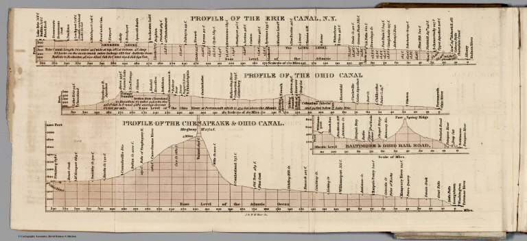
Full Title
Profile of the Erie Canal N.Y. ; Profile of the Ohio Canal ; Profile of the Chesapeake & Ohio Canal. (with inset profile) Baltimore & Ohio railroad. (to accompany) A Description of the Canals and Railroads of the United States.
List No
0979.005
Note
Three profiles on one page.
Author
Tanner, Henry S.
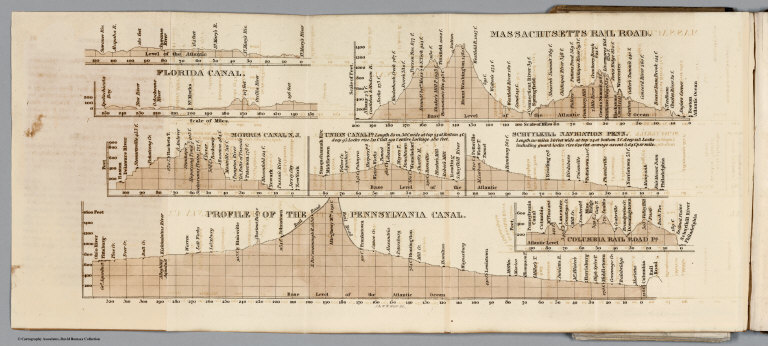
Full Title
Florida Canal ; Morris Canal N. J. ; Union Canal Pa. ; Schuylkill Navigation Penn. ; Profile of the Pennsylvania Canal. (with inset profile) Columbia railroad Pa. (to accompany) A Description of the Canals and Railroads of the United States.
List No
0979.006
Note
Six profiles on one page.
Author
Tanner, Henry S.
Full Title
Map of the canals & railroads of the United States, reduced from the large map of the U.S. by H. S. Tanner. Published T. R. Tanner & J. Disturnell, 124 Broadway, New York, 1840. Engraved by J. Knight. Entered ... 1840, by T.R. Tanner ... Pennsylvania. ( inset continuation map of ) South part of Florida ; Chesapeake & Delaware Canal ; Dismal Swamp Canal ; Welland Canal ; Lehigh navigation.
List No
0979.010
Note
Map shows canals and roads in color, folded into brown cloth covered boards. With one inset and four cross sections. Includes explanation. Prime meridian is Washington.
Author
Tanner, Henry S.
Full Title
The Travellers Guide or Map of the Roads, Canals & Rail Roads of The United States, With the Distances From Place to Place. By H.S. tanner 1844. Published by H.S. Tanner... Philadelphia. Entered ... 1834, by H.S. Tanner ... Pennsylvania.
List No
0983.003
Note
Full color map. With references and 11 insets showing major cities. Rail Roads are hand colored in red. Bookplate of Tanner's Map Store, N.Y. 144 page Guide Book. Includes maps and reference guides. New copyright notice of 1844 indicating that this is a very late edition; the map is changed from the earlier editions but is still copyright 1834, as in the earlier editions. Full color map entitled, "The Travellers Guide or Map of The Roads, Canals & Rail Roads of the United States, With the distances from place to place by H.S. Tanner 1844." at bottom, "Entered ... 1834, by H.S. Tanner ... Pennsylvania." Bound in linen with gild title, "Tanner's American Traveller or Guide through the United States with Maps, Plans &c."
Author
Chicago, Burlington & Quincy Railroad Company
Full Title
Correct map of the Burlington Route C.B. & Q.R.R. and connecting lines. Copyright 1883 by Rand, McNally & Co., Chicago.
List No
10091.003
Note
Edition for September 1885. Relief shown by hachures. Covers U.S. except for southern parts of Texas and Florida and eastern and northern Maine. Includes inset maps of the route from Chicago to Australia and "Map showing location of railroad depots, public buildings, etc. in Chicago," and text. Printed in full color.
Author
Tunis, W.E.
Full Title
Tunis' New Colored Railroad Map Of The United States & Canadas. Revised And Corrected Every Month. William E. Tunis, Bookseller and Stationer, 153 Jefferson Avenue, Detroit, Michigan ... Entered ... 1859, by W.E. Tunis ... New York.
List No
1014.000
Note
Map is in black and white with railroad lines shown in red. "The continuous red lines represent rail roads completed. The dotted red lines represent roads projected." With a view of a train traveling across a bridge, engraved by J.W. Orr in New York.
Author
شكوفه مقبل [Şukufe Mukbil]
Full Title
(North and Central America with Railroads)
List No
10992.038
Note
Dimensions are sheet size.
Author
شكوفه مقبل [Şukufe Mukbil]
Full Title
(United States with railroads)
List No
10992.041
Note
Dimensions are sheet size.
Author
Union Pacific Railroad Company
Full Title
Geographically correct map of the United States, issued by Union Pacific Railroad. Rand McNally & Company, Chicago. Copyright, 1942 by C. J. Collins Union Pacific Railroad. (insets) Union Pacific Railroad, connecting lines over Pacific Ocean. (with) Union Pacific Railroad, connecting lines over Atlantic Ocean. (cover title) Military map of the United States. The progressive Union Pacific Railroad. 6-52544. Printed in U.S.A. Copyright 1944. Rand McNally, Chicago.
List No
11259.003
Note
Color map of the United States on sheet 46x81, folded to 23x10. Showing state boundaries, place names, roads, rivers, railroad stations, locations of air fields, naval and army installations. Text on verso includes List of military posts, strategic middle routes and location of Union Pacific Offices.
Author
[Whitney-Graham Company, Inc., Southern Railway (U.S.), Funk & Wagnalls Company.]
Full Title
Map of the Southern railway system. 1929. The Southern Railway. 2-29. (to accompany) The blue book of map making : America's map makers. R.W.C. The Whitney-Graham Co. Inc. (insets) Southern Florida. (with) Cuba.
List No
11489.020
Note
Color map of the Southern and Eastern States. Showing state boundaries, cities, towns and roads. Southern Railway single and double tracks in red and tracks operated separately shown in blue. Includes station index and legend.
Author
[Walling, H.F., Hitchcock, C.H.]
Full Title
Railroad Map of the United States.
List No
1149.027
Note
Hand tinted in full color.
Author
[Union Atlas Co., Warner & Beers]
Full Title
New railroad map of the United States, and Dominion of Canada. (Union Atlas Co., Warner & Beers, Proprietors. Lakeside Building Cor: of Clark & Adams Sts. Chicago. 1876. Entered ... 1876 by Warner & Beers ... Washington D.C.)
List No
1159.144
Note
Col. lithographed map. Relief shown by hachures. Includes small view below title.
Author
Atchison, Topeka and Santa Fe Railway Co.
Full Title
Santa Fe - The Atchison, Topeka and Santa Fe Railway Co. and Connections.
List No
12045.024
Note
Two page (four panel) spread.
Author
[Cram, George F., Bennett, J.Q.A., Beers, J.H.]
Full Title
United States.
List No
12048.008
Author
J.L. Smith Co.
Full Title
Locomotive Map of the United States.
List No
12339.000
Author
Rand McNally and Company
Full Title
Southern Pacific's Four Great Routes to the West Coast.
List No
12341.000
Note
Date estimated.
Author
Lloyd, James T.
Full Title
Lloyd's Map of the Lower Mississippi River from St. Louis to the Gulf of Mexico.
List No
12387.002
Note
Made up of 5 map panels which form a single map, when assembled (see our composite map, List No. 12387.003).
Author
Gordenier, W.H.
Full Title
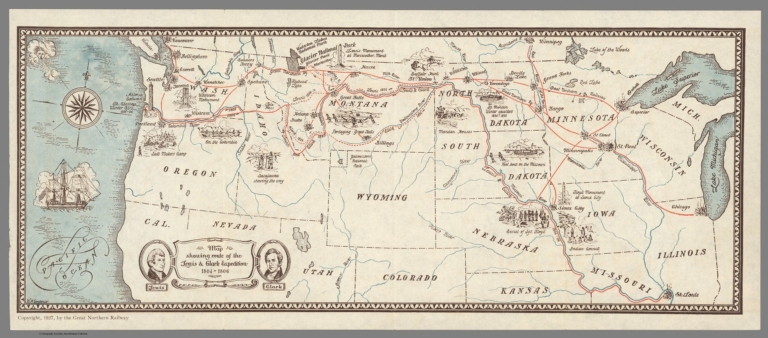
Map showing route of the Lewis & Clark Expedition 1804-1806.
List No
12414.000
Note
Also shows route of the Great Northern Railway.
Author
[James, Kerns & Abbott Co., Southern Pacific Lines]
Full Title
Southern Pacific Lines.
List No
12457.003
Note
Date estimated.
Author
[Southern Pacific Lines, Gifford]
Full Title
(Composite Text) Southern Pacific Lines.
List No
12457.004
Note
Date estimated.
Author
[Ministere des Travaux Publics, Cheysson, Émile]
Full Title
Mouvement Sur les Chemins de Fer du Monde Pendant L'Annee 1883. (Movement on the railroads of the world in 1883.)
List No
12516.014
Note
Graph type: concentric circle.
Author
[Ministere des Travaux Publics, Cheysson, Émile]
Full Title
Resultats D'Exploitation des Chemins de Fer du Monde Pendant L'Annee 1883. (Turnover of the railroads of the world in 1883.)
List No
12516.017
Note
Graph type: divided concentric circle.
Author
Southern Pacific Company
Full Title
Southern Pacific Lines map of the United States and Mexico. By Southern Pacific Co., 1929. Southern Pacific Lines. Office of Chief Engineer, Southern Pacific Company. Rev. Mar. 15, 1934, Rev. Sept. 12, 1934.
List No
13521.000
Author
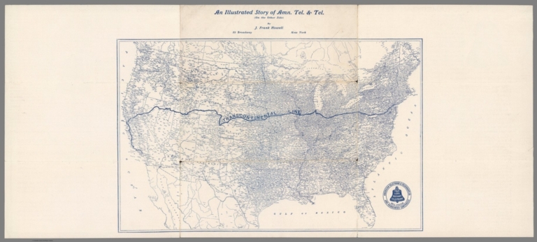
Howell, J. Frank
Full Title
(Transcontinental line) : An illustrated story of Amn. Tel. & Tel. (on the other side) by J. Frank Howell, 52 Broadway, New York.
List No
14040.001
Note
Map of the United States showing the "Transcontinental Line" spanning the country from New York City to Los Angeles. Printed with blue ink. Includes seal for American Telephone & Telegraph Co. Map 22 x 35 cm, on sheet 27 x 61 cm.
Author
New England Railway Publishing Company
Full Title
ABC, The pathfinder railway guide map : Western section. Issued by the New England Railway Publishing Company, 67 Federal St., Boston, Mass. Copyright, 1902.
List No
14042.000
Note
Map of the United States showing railroads in red lines, with stations. Map 70 x 108 cm, on sheet 77 x 115 cm. With 5 insets: Alaska -- Yellowstone Park -- Philippine Islands -- Guam -- Hawaiian Islands.
Author
[Bauer, Hubert A. (Hubert Anton), 1886-, American Airlines Inc., News Map of the Week, Inc.]
Full Title
World News of the Week : Monday, Feb. 12, 1951. Covering period Feb. 2 to Feb. 8. Volume 13, No. 24. Published and copyrighted (weekly), 1951, by News Map of the Week, Inc., 1512 Orleans Street, Chicago, Illinois. Published in two sections : Section one. Lithographed in U. S. A. Cartographer, H. A. Bauer. Base map copyrighted by American Airlines, Inc.
List No
14223.000
Note
Lithographed world map, in color. Shows political boundaries and significant events from February 2 to 8, 1951. Relief illustrated with hachures. "This map - an azimuthal projection focused upon the geographical center of the United States - was developed by air-age education research of American Airlines, Inc." Includes information on bauxite across the globe, with explanation, as well as descriptive text throughout, e.g.: Gold Coast : 120,000 tons. Map indexed according to historical notes beneath map. With inset map: The rail strike. Also, with three diagrams: The rail strike -- Deaths from accidents -- Highlights of the administration's $10,000,000,000 tax program. Map is 61 x 64 cm, on sheet 89 x 120 cm, folded to 31 x 23 cm.
Author
[Geological Survey (U.S.), Shaw, W. James II., United States. Army]
Full Title
Major rail network : 1966 / W. James Shaw, II, U. S. Department of the Army, 1966.
List No
14359.174
Note
Transportation map representing the United States, featuring the geographic locations of the major railway network, including primary and secondary railroads, as of 1966. Map also shows political boundaries, time zones, topography, bodies of water, drainage, coastlines and islands. Relief shown with shading. Includes a legend, as well as a bar scale and scale statement. Presented with Albers Equal Area Projection. With two inset maps: Principal islands of Hawaii -- Alaska. Colored lithograph. Map is 43 x 66 cm, on double sheet 49 x 71 cm. Appears in Special subject maps section, subsection Economic : Transportation.
Author
Whitney, Asa
Full Title
No. 2 ( A map of North America showing possible rail routes across the continent.) Miller's Lith. 102 Broadway, N.Y. "N.B. this map shews very nealy the sphere of the Globe, and the line from Baltimore and the line from Panama to Puget Sound, would be the air line route. (to accompany) A Project For A Railroad To The Pacific. By Asa Whitney, of New York.
List No
1466.005
Note
Untitled map of North America showing possible rail routes across the continent. Includes notes on Northern route and Southern route, The Galveston route and St. Louis routes, with distances in miles from place to place. Relief shown by hachures. Title supplied by cataloger.
Author
United States. Central Intelligence Agency
Full Title
(Text Page to) Railroads. (to accompany) People's Republic of China - Atlas. November 1971. Central Intelligence Agency.
List No
1507.024
Note
Includes two color map of the United States and China. with three black and white views of railroad construction.
Full Title
372. Railroad systems of the United States: 1890. Julius Bien & Co. Lith., N.Y. (1898)
List No
1873.060
Note
Color lithographed map.
Author
Bradford, Thomas G.
Full Title
United States, exhibiting the railroads & canals. (to accompany) A Comprehensive Atlas, Geographical, Historical & Commercial. By T.G. Bradford. Boston: American Stationers' Company. Entered ... 1835, by Thos. G. Bradford ... Massachusetts.
List No
2120.064
Note
Color map. Shows administrative boundaries, railroads, canals, Indian territories, rivers, etc. Relief shown pictorially. Prime meridian is Washington.
Author
Bradford, Thomas G.
Full Title
(Text Page to) Railroads and canals. (to accompany) A Comprehensive Atlas, Geographical, Historical & Commercial. By T.G. Bradford. Boston: American Stationers' Company. Entered ... 1835, by Thos. G. Bradford ... Massachusetts.
List No
2120.065
Note
Text to the railroads and canals in the United States and other countries.
Author
Warren, Gouverneur Kemble, 1830-1882
Full Title
Map Of The Territory Of The United States From The Mississippi To The Pacific Ocean Ordered by the Hon. Jeff'n Davis, Secretary Of War To accompany the Reports of the Explorations For A Railroad Route ... Compiled from authorized explorations and other reliable data by Lieut. G.K. Warren, Topl. Engrs. In the Office of Pacific R.R. Surveys, War Dep. under the direction of Bvt. Maj. W.H. Emory and Capt. A.A. Humphreys, Topl. Engrs. 1855. Engr. by Selmar Siebert.
List No
2289.000
Note
Very early issue of Warren's Pacific Railroad general map of the U.S. When the Pacific Railway Survey reports were published in 1855, the large Warren map of the U.S. was not completed and a smaller map was issued with a note by Warren that the larger map would soon be ready for publication. This issue of the map is dated 1855 only, unlike the final issue which was dated 1854-5-6-7 (see our #0693). Also, the list of authorities here is shorter than the later issue and has no dates later than 1855. Most importantly, this issue has major areas blank that are filled in the final issue. Various routes are drawn in ms on the map, in red and blue lines, all proceeding from points in the Midwest to the west coast, as well as some north - south routes. Also, a red line is drawn from east to west next to the 38th parallel. We think these are the trails used by travelers, perhaps a few years later, but we can't be sure. There is another early issue of this map that is between this 1855 issue and the version published with the final reports - it is dated 1857, has fewer "blank" areas that this and has more and later dated authorities (see WH copy).
Author
Poussin, Guillaume Tell, 1794-1876
Full Title
Carte generale des Etats-Unis d'Amerique. Avec l'indication de la partie navigable de chaque riviere ainsi que le trace des canaux de navigation et chemins de fer tant executes qu'en execution. Dressee par le Major Poussin, pour servir a son ouvrage sur les travaux d'ameliorations interieures executes ou projetes par le gouvernement des Etats-Unis de 1824 a 1831. 1834.
List No
2329.001
Note
Engraved map showing settlements, Indian villages, post roads, etc. Includes inset of southern Florida. Prime meridian: [Washington]
Author
Powell, John Wesley, 1834-1902.
Full Title
Map of the United States exhibiting the grants of lands made by the general government to aid in the construction of railroads and wagon roads. For explanation see chapter on "L̀and grants in aid of internal improvements". Julius Bien, Lithographer. (at head of title) Department of the Interior, U.S. Geographical and Geological Survey of the Rocky Mountain region, J.W. Powell in charge. (on upper margin) To accompany report on the Lands of the Arid Region of the U.S.
List No
2347.010
Note
Color map. Shows land grant s to railroads and wagon roads, and limit to grants. "The base chart was engraved for the Statistical atlas of the United States".
Author
Powell, John Wesley, 1834-1902.
Full Title
Rain chart of the United States : showing by isohyetal lines the distribution of the mean annual precipitation in rain and melted snow. This is a copy of the chart constructed for the Smithsonian Institution in 1868 by Charles A Schott ... Julius Bien, Lithographer. (at head of title) Department of the Interior, U.S. Geographical and Geological Survey of the Rocky Mountain region, J.W. Powell in charge. (on upper margin) To accompany report on the Lands of the Arid Region of the U.S.
List No
2347.011
Note
Color map. Showing isothermal lines. Includes explanation. "The base chart was engraved for the Statistical atlas of the United States".
Author
Tanner, Henry S.
Full Title
(Covers to) The American Traveller; Or Guide Through the United States. Containing Brief Notices of the Several States, Cities, Principal Towns ... Alphabetically arranged, Eighth Edition. By H.S. Tanner. Philadelphia: Published by H. Tanner, Jr. New York: T.R. Tanner. 1842. (on verso) Entered ... 1839, by H.S. Tanner ... Pennsylvania. With direct References to the accompanying Map "The Travellers Guide or Map of the Roads, Canals, and Railways of the United States. With the distances from place to place by H.S. Tanner.
List No
2528.001
Note
8th edition, published by H. Tanner Jr. in Philadelphia and T.R. Tanner in New York, both presumably H. Tanner senior's sons. The large map appears unchanged from the 1840 edition. Large outline color map bound in back entitled, "The Travellers Guide or Map of the Roads, Canals & Rail Roads of the United States, With the distances from place to place by H.S. Tanner." At bottom of map, "Entered ... 1834, by H.S. Tanner ... Pennsylvania." Book bound with linen and with title embossed on cover, "Tanner's American Traveller or Guide through the United States with Maps, Plans &c. 1842."
Author
Tanner, Henry S.
Full Title
(Title Page to) The American Traveller; Or Guide Through the United States. Containing Brief Notices of the Several States, Cities, Principal Towns ... Alphabetically arranged, Eighth Edition. By H.S. Tanner. Philadelphia: Published by H. Tanner, Jr. New York: T.R. Tanner. 1842. (on verso) Entered ... 1839, by H.S. Tanner ... Pennsylvania. With direct References to the accompanying Map "The Travellers Guide or Map of the Roads, Canals, and Railways of the United States. With the distances from place to place by H.S. Tanner.
List No
2528.002
Note
8th edition, published by H. Tanner Jr. in Philadelphia and T.R. Tanner in New York, both presumably H. Tanner senior's sons. The large map appears unchanged from the 1840 edition. Large outline color map bound in back entitled, "The Travellers Guide or Map of the Roads, Canals & Rail Roads of the United States, With the distances from place to place by H.S. Tanner." At bottom of map, "Entered ... 1834, by H.S. Tanner ... Pennsylvania." Book bound with linen and with title embossed on cover, "Tanner's American Traveller or Guide through the United States with Maps, Plans &c. 1842."
Author
Tanner, Henry S.
Full Title
The Travellers Guide or Map of the Roads, Canals, and Railways of the United States. With the Distances from Place to Place by H.S. Tanner. (with inset 8 inset maps). (with the accompanying guide) The American Traveller; Or Guide Through the United States. Containing Brief Notices of the Several States, Cities, Principal Towns ... Alphabetically arranged, Eighth Edition. By H.S. Tanner. Philadelphia: Published by H. Tanner, Jr. New York: T.R. Tanner. 1842. (on verso) Entered ... 1839, by H.S. Tanner ... Pennsylvania.
List No
2528.003
Note
8th edition, published by H. Tanner Jr. in Philadelphia and T.R. Tanner in New York, both presumably H. Tanner senior's sons. The large map appears unchanged from the 1840 edition. Large outline color map bound in back entitled, "The Travellers Guide or Map of the Roads, Canals & Rail Roads of the United States, With the distances from place to place by H.S. Tanner." At bottom of map, "Entered ... 1834, by H.S. Tanner ... Pennsylvania." Book bound with linen and with title embossed on cover, "Tanner's American Traveller or Guide through the United States with Maps, Plans &c. 1842."
Author
Tanner, Henry S.
Full Title
Baltimore
List No
2528.004
Note
8th edition, published by H. Tanner Jr. in Philadelphia and T.R. Tanner in New York, both presumably H. Tanner senior's sons. The large map appears unchanged from the 1840 edition. Large outline color map bound in back entitled, "The Travellers Guide or Map of the Roads, Canals & Rail Roads of the United States, With the distances from place to place by H.S. Tanner." At bottom of map, "Entered ... 1834, by H.S. Tanner ... Pennsylvania." Book bound with linen and with title embossed on cover, "Tanner's American Traveller or Guide through the United States with Maps, Plans &c. 1842."
Author
Tanner, Henry S.
Full Title
Boston
List No
2528.005
Note
8th edition, published by H. Tanner Jr. in Philadelphia and T.R. Tanner in New York, both presumably H. Tanner senior's sons. The large map appears unchanged from the 1840 edition. Large outline color map bound in back entitled, "The Travellers Guide or Map of the Roads, Canals & Rail Roads of the United States, With the distances from place to place by H.S. Tanner." At bottom of map, "Entered ... 1834, by H.S. Tanner ... Pennsylvania." Book bound with linen and with title embossed on cover, "Tanner's American Traveller or Guide through the United States with Maps, Plans &c. 1842."
Author
Tanner, Henry S.
Full Title
New York
List No
2528.006
Note
8th edition, published by H. Tanner Jr. in Philadelphia and T.R. Tanner in New York, both presumably H. Tanner senior's sons. The large map appears unchanged from the 1840 edition. Large outline color map bound in back entitled, "The Travellers Guide or Map of the Roads, Canals & Rail Roads of the United States, With the distances from place to place by H.S. Tanner." At bottom of map, "Entered ... 1834, by H.S. Tanner ... Pennsylvania." Book bound with linen and with title embossed on cover, "Tanner's American Traveller or Guide through the United States with Maps, Plans &c. 1842."
Author
Tanner, Henry S.
Full Title
Philadelphia and Environs
List No
2528.007
Note
8th edition, published by H. Tanner Jr. in Philadelphia and T.R. Tanner in New York, both presumably H. Tanner senior's sons. The large map appears unchanged from the 1840 edition. Large outline color map bound in back entitled, "The Travellers Guide or Map of the Roads, Canals & Rail Roads of the United States, With the distances from place to place by H.S. Tanner." At bottom of map, "Entered ... 1834, by H.S. Tanner ... Pennsylvania." Book bound with linen and with title embossed on cover, "Tanner's American Traveller or Guide through the United States with Maps, Plans &c. 1842."
Author
Tanner, Henry S.
Full Title
Manuscript Drawing
List No
2528.008
Note
8th edition, published by H. Tanner Jr. in Philadelphia and T.R. Tanner in New York, both presumably H. Tanner senior's sons. The large map appears unchanged from the 1840 edition. Large outline color map bound in back entitled, "The Travellers Guide or Map of the Roads, Canals & Rail Roads of the United States, With the distances from place to place by H.S. Tanner." At bottom of map, "Entered ... 1834, by H.S. Tanner ... Pennsylvania." Book bound with linen and with title embossed on cover, "Tanner's American Traveller or Guide through the United States with Maps, Plans &c. 1842."
Author
Watson, Gaylord
Full Title
(Covers to) Watson's New County and Railroad Map of the United States and the Dominion of Canada Compiled From the Latest Official Sources, 1874. Published by Gaylord Watson, 16 Beekman St., New York. Entered ... 1871, by Gaylord Watson ... Washington. (with) 5 inset maps: Routes of the Union, Central & Kansas Pacific Railroad; Vicinity of Boston; Vicinity of Philadelphia; Vicinity of New York; Lower Part of Florida.
List No
2540A
Note
5 inset maps, Vignette of Locomotive under title. Shows the route of the "Proposed Atlantic and Great Western Canal." Also an inset of the Union, Central & Kansas Pacific Railroad. Population tables, statistics, etc. Highly detailed map showing railroads and counties and cities in the eastern part of the U.S. and Canada. Has "United States" on the cover and is the companion map to the Map of the Western States... with "Territories" (see #2539.000) on its cover. Copyright date is 1871. For some reason, Modelski does not list all these early Watson maps, but only a few maps dated 1874 and later; perhaps Watson did not deposit all his maps with the LOC.
Author
Watson, Gaylord
Full Title
Watson's New County and Railroad Map of the United States and the Dominion of Canada Compiled From the Latest Official Sources, 1874. Published by Gaylord Watson, 16 Beekman St., New York. Entered ... 1871, by Gaylord Watson ... Washington. (with) 5 inset maps: Routes of the Union, Central & Kansas Pacific Railroad; Vicinity of Boston; Vicinity of Philadelphia; Vicinity of New York; Lower Part of Florida.
List No
2540.001
Note
5 inset maps, Vignette of Locomotive under title. Shows the route of the "Proposed Atlantic and Great Western Canal." Also an inset of the Union, Central & Kansas Pacific Railroad. Population tables, statistics, etc. Highly detailed map showing railroads and counties and cities in the eastern part of the U.S. and Canada. Has "United States" on the cover and is the companion map to the Map of the Western States... with "Territories" (see #2539.000) on its cover. Copyright date is 1871. For some reason, Modelski does not list all these early Watson maps, but only a few maps dated 1874 and later; perhaps Watson did not deposit all his maps with the LOC.
Author
Lloyd, J.T.
Full Title
(Covers to) Lloyd's New Map of the United States The Canadas And New Brunswick From the latest Surveys Showing Every Railroad & Station Finished to June 1863 And The Atlantic And Gulf Coasts ... 1863 ... Address J.T. Lloyd, No. 164 Broadway, New York, and 1 Strand, London, England. Entered ... 1863, by J.T. Lloyd ... New York.
List No
2591.001
Note
1st edition was issued in June, 1862. Interesting note on his competitor, H.H. Lloyd. Shows U.S. west to the 103 meridian. Dated 1864 on the cover. Has a catalogue of Lloyd's works. Map is full color by county, folded into embossed light brown cloth covers 18x11.5 with "Lloyd's New-Map Of The United States And Canadas. 1864" in gold.
Author
Lloyd, J.T.
Full Title
Lloyd's New Map of the United States The Canadas And New Brunswick From the latest Surveys Showing Every Railroad & Station Finished to June 1863 And The Atlantic And Gulf Coasts ... 1863 ... Address J.T. Lloyd, No. 164 Broadway, New York, and 1 Strand, London, England. Entered ... 1863, by J.T. Lloyd ... New York.
List No
2591.002
Note
1st edition was issued in June, 1862. Interesting note on his competitor, H.H. Lloyd. Shows U.S. west to the 103 meridian. Dated 1864 on the cover. Has a catalogue of Lloyd's works. Map is full color by county, folded into embossed light brown cloth covers 18x11.5 with "Lloyd's New-Map Of The United States And Canadas. 1864" in gold. Prime meridian is Greenwich. Relief shown by hacures.
Author
Perris, William
Full Title
(Covers to) A New And Complete Rail Road Map Of The United States, Compiled from Reliable Sources by William Perris, C.E. & Surveyor, New York. Presented by the Home Insurance Company of New York ... Office Nos. 112 & 114 Broadway ... Korff Brothers Practical Lithographers 54 William St. New York.
List No
2617.001
Note
Presented by the Home Insurance Co., New York. Elaborate cartouche with an advertisement for the Home Insurance Co. in the middle. Shows railroads west to the 97th meridian. Full color by state. Folded into textured brown cloth covers 15x9.5 with "Presented By The Home Insurance Company. Of New-York. Cash Capital $600,000. Surplus over $250,000. 1858" stamped in gilt.
Author
Perris, William
Full Title
A New And Complete Rail Road Map Of The United States, Compiled from Reliable Sources by William Perris, C.E. & Surveyor, New York. Presented by the Home Insurance Company of New York ... Office Nos. 112 & 114 Broadway ... Korff Brothers Practical Lithographers 54 William St. New York.
List No
2617.002
Note
Presented by the Home Insurance Co., New York. Elaborate cartouche with an advertisement for the Home Insurance Co. in the middle. Shows railroads west to the 97th meridian. Full color by state. Folded into textured brown cloth covers 15x9.5 with "Presented By The Home Insurance Company. Of New-York. Cash Capital $600,000. Surplus over $250,000. 1858" stamped in gilt.
Author
Bradford, Thomas G.
Full Title
United States, exhibiting the railroads & canals. (to accompany) A Comprehensive Atlas, Geographical, Historical & Commercial. By T.G. Bradford. William D. Ticknor, Boston. Wiley & Long, New-York. Entered ... 1835, by Thos. G. Bradford ... Massachusetts.
List No
2643.064
Note
Outline color map by administrative boundaries. Shows railroads, canals, Indian territories, rivers, etc. Relief shown pictorially. Prime meridian is Washington.
Author
[Freyhold, Edward, Warren, Gouverneur Kemble, 1830-1882]
Full Title
Map Of The Territory Of The United States From The Mississippi To The Pacific Ocean; Ordered by the Hon. Jeff'n Davis, Secretary Of War To accompany the Reports of the Explorations For A Railroad Route ... Compiled from authorized explorations and other reliable data by Lieut. G.K. Warren, Topl. Engrs. In the Office of Pacific R.R. Surveys, War Dep. under the direction of Bvt. Maj. W.H. Emory, Topl. Engrs. in 1854 and of Capt. A.A. Humphreys, Topl. Engrs. 1854-5-6-7-8. Drawn by E. Freyhold. Engr. on Stone by J. Bien, 60 Fulton St. N.Y.
List No
2750.000
Note
2nd 1858 edition, adds Ives Grand Canyon expedition. Also adds information from Warren's third expedition. Schubert says there was an earlier 1858 edition that filled in information in Oregon but did not include the Ives information. Schubert also quotes a letter from Warren stating that this edition was sent to the printer in 1859. Freyhold's name appears on the title for the first time. It is dropped in the next (1867) edition and then reappears in the 1868 edition. Rare - apparently there is only one other copy of this map - in the Millard Fillmore Map Collection in the LOC (see Stephenson article in Map Collector No. 12). This copy came from the Bancroft Library as a duplicate - perhaps they thought it was a duplicate of the 1857 edition. With brown wood side rollers. Map is without color and mounted on linen.
Author
Goldthwait, J.H.
Full Title
(Covers to) Goldthwait's Map Of The United States, British Provinces, Mexico, Central America, W. India Is. &c. Exhibiting The Railroads ... by J.H. Goldthwait. Published by D. Chester, 119 & 121 Nassau St. New York. Entered ... 1861 by J.H. Goldthwait ... New York. (inset) Great Rail Road Routes from the Middle Atlantic Ports To The Mississippi River by J.H. Goldthwait. (inset) Of The Railroads Of New England And Eastern N . York by J.H. Goldthwait.
List No
2762.001
Note
Important U.S. Railroad map; civil war references. Goldthwait did an early map of the Mississippi Valley in 1833 (see Karrow index), engraved for Johnson (large N.A. 1859) and Colton (County Map of N.A. 1864) and produced several beautiful railroad maps. Colton put out a later edition of this map (see Phillips 909). This map is extraordinary for its graphic clarity and elegance. Two inset maps show railroad routes in New England and the Mid West. The west is largely empty except for California where many towns are listed along with topographical features. Many lists of statistics are provided (showing population growth) as well as a list of the seceding southern states with dates of secession. Railroad routes are shown as single and double track, including the width of the gauge. Full color map, folded into textured brown cloth covers 14.5x9 with "Goldthwait's Map Of The United States & Canada" stamped in gilt. Relief shown by hachures.
Author
Goldthwait, J.H.
Full Title
Goldthwait's Map Of The United States, British Provinces, Mexico, Central America, W. India Is. &c. Exhibiting The Railroads ... by J.H. Goldthwait. Published by D. Chester, 119 & 121 Nassau St. New York. Entered ... 1861 by J.H. Goldthwait ... New York. (inset) Great Rail Road Routes from the Middle Atlantic Ports To The Mississippi River by J.H. Goldthwait. (inset) Of The Railroads Of New England And Eastern N . York by J.H. Goldthwait.
List No
2762.002
Note
Important U.S. Railroad map; civil war references. Goldthwait did an early map of the Mississippi Valley in 1833 (see Karrow index), engraved for Johnson (large N.A. 1859) and Colton (County Map of N.A. 1864) and produced several beautiful railroad maps. Colton put out a later edition of this map (see Phillips 909). This map is extraordinary for its graphic clarity and elegance. Two inset maps show railroad routes in New England and the Mid West. The west is largely empty except for California where many towns are listed along with topographical features. Many lists of statistics are provided (showing population growth) as well as a list of the seceding southern states with dates of secession. Railroad routes are shown as single and double track, including the width of the gauge. Full color map, folded into textured brown cloth covers 14.5x9 with "Goldthwait's Map Of The United States & Canada" stamped in gilt. Relief shown by hachures.
Author
[Mitchell, Samuel Augustus, Drake, Ira S.]
Full Title
(Covers to) Mitchell's New Traveller's Guide Through The United States, Containing The Principal Cities, Towns &c. ... Illustrated By An Accurate Map Of The United States. Philadelphia: Thomas, Cowperthwait & Co. 1849. (on verso) Entered ... 1848, by Thomas, Cowperthwait & Co. ... Pennsylvania. Stereotyped by J. Fagan. Printed by Smith & Peters. (with map) Mitchell's New Traveller's Guide Through The United States, Showing the Rail Roads, Canals, Stage Roads &c. ... Drawn and Engraved by Ira S. Drake. Philadelphia 1849 Published by Thomas, Cowperthwait & Co. Entered ... 1848, by Thomas, Cowperthwait, & Co. ... Pennsylvania. (with 5 inset maps).
List No
2766.001
Note
This is a major revision of the guide with an entirely new map by Ira S. Drake (about whom we find nothing) with five inset maps entitled - "Vicinity Of Niagara Falls", "Map Of The Copper Mine Region", "Map of the Gold and Quicksilver district of California", "Map of the Maritime and Overland Routes to California", and "Map Of New England Or Eastern States". The map emphasis on the California gold rush is clear, although the 128 pages of expanded text do not yet list routes to the gold fields, while they do add routes west from St. Louis and Independence. The main map is larger than the earlier Mitchell/Young maps, but shows roughly the same area on a somewhat larger scale. An "Advertisement" (actually a preface) dated Nov. 1, 1848, states: "The following work is similar in design to 'Mitchell's Traveller's Guide,' first published about twelve years ago, and which has been so extremely patronized, that it may be safely asserted no book of the kind ever printed in this country has met with so wide a circulation." Covers are black stamped leather with "Mitchell's New Traveller's Guide Through The United States" and a beautiful illustration of a steam boat and train stamped in gilt. Map is outline color. Catalogue of Thomas, Cowperthwait School Books included in the text.
Author
[Mitchell, Samuel Augustus, Drake, Ira S.]
Full Title
(Title Page to) Mitchell's New Traveller's Guide Through The United States, Containing The Principal Cities, Towns &c. ... Illustrated By An Accurate Map Of The United States. Philadelphia: Thomas, Cowperthwait & Co. 1849. (on verso) Entered ... 1848, by Thomas, Cowperthwait & Co. ... Pennsylvania. Stereotyped by J. Fagan. Printed by Smith & Peters. (with map) Mitchell's New Traveller's Guide Through The United States, Showing the Rail Roads, Canals, Stage Roads &c. ... Drawn and Engraved by Ira S. Drake. Philadelphia 1849 Published by Thomas, Cowperthwait & Co. Entered ... 1848, by Thomas, Cowperthwait, & Co. ... Pennsylvania. (with 5 inset maps).
List No
2766.002
Note
This is a major revision of the guide with an entirely new map by Ira S. Drake (about whom we find nothing) with five inset maps entitled - "Vicinity Of Niagara Falls", "Map Of The Copper Mine Region", "Map of the Gold and Quicksilver district of California", "Map of the Maritime and Overland Routes to California", and "Map Of New England Or Eastern States". The map emphasis on the California gold rush is clear, although the 128 pages of expanded text do not yet list routes to the gold fields, while they do add routes west from St. Louis and Independence. The main map is larger than the earlier Mitchell/Young maps, but shows roughly the same area on a somewhat larger scale. An "Advertisement" (actually a preface) dated Nov. 1, 1848, states: "The following work is similar in design to 'Mitchell's Traveller's Guide,' first published about twelve years ago, and which has been so extremely patronized, that it may be safely asserted no book of the kind ever printed in this country has met with so wide a circulation." Covers are black stamped leather with "Mitchell's New Traveller's Guide Through The United States" and a beautiful illustration of a steam boat and train stamped in gilt. Map is outline color. Catalogue of Thomas, Cowperthwait School Books included in the text.
Author
[Mitchell, Samuel Augustus, Drake, Ira S.]
Full Title
Mitchell's New Traveller's Guide Through The United States, Showing the Rail Roads, Canals, Stage Roads &c. ... Drawn and Engraved by Ira S. Drake. Philadelphia 1849 Published by Thomas, Cowperthwait & Co. Entered ... 1848, by Thomas, Cowperthwait, & Co. ... Pennsylvania. (with 5 inset maps). (with guide book) Mitchell's New Traveller's Guide Through The United States, Containing The Principal Cities, Towns &c. ... Illustrated By An Accurate Map Of The United States. Philadelphia: Thomas, Cowperthwait & Co. 1849. (on verso) Entered ... 1848, by Thomas, Cowperthwait & Co. ... Pennsylvania. Stereotyped by J. Fagan. Printed by Smith & Peters.
List No
2766.003
Note
This is a major revision of the guide with an entirely new map by Ira S. Drake (about whom we find nothing) with five inset maps entitled - "Vicinity Of Niagara Falls", "Map Of The Copper Mine Region", "Map of the Gold and Quicksilver district of California", "Map of the Maritime and Overland Routes to California", and "Map Of New England Or Eastern States". The map emphasis on the California gold rush is clear, although the 128 pages of expanded text do not yet list routes to the gold fields, while they do add routes west from St. Louis and Independence. The main map is larger than the earlier Mitchell/Young maps, but shows roughly the same area on a somewhat larger scale. An "Advertisement" (actually a preface) dated Nov. 1, 1848, states: "The following work is similar in design to 'Mitchell's Traveller's Guide,' first published about twelve years ago, and which has been so extremely patronized, that it may be safely asserted no book of the kind ever printed in this country has met with so wide a circulation." Covers are black stamped leather with "Mitchell's New Traveller's Guide Through The United States" and a beautiful illustration of a steam boat and train stamped in gilt. Map is outline color. Catalogue of Thomas, Cowperthwait School Books included in the text. Prime meridian is Washington D.C.
Author
Cram, George Franklin
Full Title
Map of the United States of America. (inset) Alaska.
List No
2809.108
Note
Relief shown by hachures. Prime meridians Washington D.C. and Greenwich.
Author
Lloyd, J. T.
Full Title
Lloyd's New Map of the United States The Canadas and New Brunswick From The Latest Surveys Showing Every Railroad & Station Finished to June 1862... 1866. (On verso: ) Lloyd's Topographical Railway Map of North America or the United States Continent in 1900....
List No
2859.002
Note
Two sided wall map -see 1866 copy. On this side, in addition to the U.S. map, there are insets of major cities and their rail lines. Similar to the 1866 edition, but some changes - on the verso North America map, adds inset of South America, the Pacific Railway route has been changed to go north of Salt Lake, some of the ads on the steamship routes have been deleted.
Author
Mitchell, Samuel Augustus
Full Title
Mitchell's Map Of The United States Showing the Principal Travelling, Turnpike and Common Roads ... Philadelphia: Published By S. Augustus Mitchell. 1835. Sold by Mitchell & Hinman No. 6 North Fifth Street. Entered ... 1835, by S. Augustus Mitchell... Pennsylvania. (with 8 inset maps). (with text) Mitchell's Compendium Of The Internal Improvements Of The United States; Comprising General Notices Of All The Most Important Canals and Rail-Roads... Philadelphia: Published By Mitchell & Hinman, No. 6 North-Fifth Street. 1835. (on verso) Entered ... 1835, by Mitchell & Hinman ... Pennsylvania. Stereotyped by John Fagan ... Philadelphia.
List No
2869.003
Note
1st edition. This guide is scarcer than Mitchell's Traveller's Guide. The outline color map is very similar to the Traveller's Guide Map - it is probably from the same plate, but covers slightly more area, has eight inset maps (the Traveller's map drops the Hartford /New Haven inset and adds two - Niagara Falls and New Orleans) instead of nine, and has a table of distances below the title. The 84 page text in this guide is a descriptive listing of Canals, Railroads, etc.; the Traveller's Guide text functions as a route book and was certainly more generally useful and had many more editions. There was only one other edition of this Compendium, in 1838 (see our #521). The map was issued separately in 1839 (see our #4950) and a printing on silk was issued in 1835 (see our #4544). Book is bound into black leather covers with "Mitchell's Compendium Of Canals & Railroads" and a decorative border stamped in gilt. Four page catalogue of Mitchell's maps. Prime meridians are Washington D.C. and Greenwich.
Author
Everts, L.H.
Full Title
Rail Road Map of the United States. Prepared Expecially for Evert's Illustrated Historical Atlas by H.H. Lloyd & Co..21 John St., N.Y.
List No
2870.005
Author
Tanner, Henry S.
Full Title
(Covers to) The Traveller's Guide Or Map Of The Roads, Canals & Rail Roads of the United States With the distances from place to place. By H.S. Tanner 1846. Published by H.S Tanner, 144 Chestnut St. Philadelphia. Entered ... 1844, by H.S. Tanner ... Pennsylvania. (with 11 inset maps).
List No
2985.001
Note
Separate issue of the map normally found with the guide. Inset maps show the environs of Albany Saratoga, Niagara Falls, Quebec, Providence, Boston, Richmond, New York, Charleston, Baltimore and Washington, Washington D.C., and Philadelphia. Full color by state. Brown cloth covers 13.5x8.5 are stamped "U. States" in gold.
Author
Tanner, Henry S.
Full Title
The Traveller's Guide Or Map Of The Roads, Canals & Rail Roads of the United States With the distances from place to place. By H.S. Tanner 1846. Published by H.S Tanner, 144 Chestnut St. Philadelphia. Entered ... 1844, by H.S. Tanner ... Pennsylvania. (with 11 inset maps).
List No
2985.002
Note
Separate issue of the map normally found with the guide. Inset maps show the environs of Albany Saratoga, Niagara Falls, Quebec, Providence, Boston, Richmond, New York, Charleston, Baltimore and Washington, Washington D.C., and Philadelphia. Full color by state. Brown cloth covers 13.5x8.5 are stamped "U. States" in gold.
Author
Rand McNally and Company
Full Title
Rand McNally & Co.'s New Railroad Junction Point And County Map Of The Eastern & Middle States. Prepared from the Latest Government Surveys, and Verified by the Working Time Tables of the Various Railroads. Drawn, Engraved, Printed, Colored By Hand And Published By Rand McNally & Co., Chicago. The Railroads on this Map are bought up to date of September 1885. Copyright, 1882, By Rand, McNally & Co. (inset) General Map Of The United States Of America Showing The Relative Geographical Position Of The Several States And Territories.
List No
3117.000
Note
Copyright 1882. Inset map of the United States. 1 of six sections. Very large map of the northeast and middle coastal areas, which, although complete by itself, was also part of a twelve sheet map in six parts (two sheets to each part) that extended west to the 105th parallel and south to Florida and measured 10x15 feet (see Modelski). All the existing railroads are shown in great detail at a scale of six miles to one inch. Because of it great size, the map was hand colored. Dissected into 49 sections and backed with linen. See our 5802.000 for a related map. Folds into dark blue cloth covered boards 31x23.
Author
[Lubrecht, Charles, Rosa, R.]
Full Title
(Covers to) The American Continent. Topographical and railroad map of the United States, British Possessions, West Indies, Mexico and Central America. Compiled from the best authorities, by R. Rosa, late Col. 46th Regt. N.Y.S. Vol. Published by Ch. Lubrecht & Co., 12 Frankfort Street, New York. 1864. Agents For Great Britain: Bacon & Co., 48 Paternoster Row, London, England. For Germany, Switzerland And Italy: Fr. Volkmar, Leipsic. Lubrecht & Co., Stuttgart. Revised Edition. Entered ... 1864, by Ch. Lubrecht & Co. ... New York. (with) Central America.
List No
3127A
Note
1st edition. 2nd edition was1865, another edition in 1869 (Karrow 1-1683). German edition published in 1864. (Karrow 1-1655). Inset of Central America, text on top of map describing British American Possessions, Time Tables, and U.S. Census for 1860. We can find no earlier edition of this map, so the "Revised Edition" is puzzling. Lubrecht lists three foreign publishers for this map: Bacon in London, Volkmar in Leipsic, and Lubrecht & Co. in Stuttgart. An edition in German is described in Karrow. Later, this map became the more elaborate 1871 "American Union Railroad Map of the United States..." by Hassis & Lubrecht, also published by D.L. Gurnsey (see our copy, WH's copy, and Heaston Cat. 19 for a reproduction). The Proposed transcontinental railroad is shown going south of Salt Lake City, Wyoming is still part of Dakota, and a Proposed Southern Pacific Railroad runs from Fort Smith to Sacramento. Full color by state. Map is dissected into 24 sections and mounted on linen. Folded into black paper covered boards 24.5x21 with "The American Continent" stamped in gilt. Relief shown by hachures.
Author
[Lubrecht, Charles, Rosa, R.]
Full Title
The American Continent. Topographical and railroad map of the United States, British Possessions, West Indies, Mexico and Central America. Compiled from the best authorities, by R. Rosa, late Col. 46th Regt. N.Y.S. Vol. Published by Ch. Lubrecht & Co., 12 Frankfort Street, New York. 1864. Agents For Great Britain: Bacon & Co., 48 Paternoster Row, London, England. For Germany, Switzerland And Italy: Fr. Volkmar, Leipsic. Lubrecht & Co., Stuttgart. Revised Edition. Entered ... 1864, by Ch. Lubrecht & Co. ... New York. (with) Central America.
List No
3127.001
Note
1st edition. 2nd edition was1865, another edition in 1869 (Karrow 1-1683). German edition published in 1864. (Karrow 1-1655). Inset of Central America, text on top of map describing British American Possessions, Time Tables, and U.S. Census for 1860. We can find no earlier edition of this map, so the "Revised Edition" is puzzling. Lubrecht lists three foreign publishers for this map: Bacon in London, Volkmar in Leipsic, and Lubrecht & Co. in Stuttgart. An edition in German is described in Karrow. Later, this map became the more elaborate 1871 "American Union Railroad Map of the United States..." by Hassis & Lubrecht, also published by D.L. Gurnsey (see our copy, WH's copy, and Heaston Cat. 19 for a reproduction). The Proposed transcontinental railroad is shown going south of Salt Lake City, Wyoming is still part of Dakota, and a Proposed Southern Pacific Railroad runs from Fort Smith to Sacramento. Full color by state. Map is dissected into 24 sections and mounted on linen. Folded into black paper covered boards 24.5x21 with "The American Continent" stamped in gilt. Relief shown by hachures.
Author
Southern Pacific Company
Full Title
(Covers to:) California, Texas, Mexico And Arizona Southern Pacific Co. "Sunset route" from New Orleans to the Pacific Coast ... January, 1892. American Bank Note Co., N.Y.
List No
3139A
Note
Self wrapper cover in color, illustrated.
Author
Southern Pacific Company
Full Title
California, Texas, Mexico And Arizona Southern Pacific Co. "Sunset route" from New Orleans to the Pacific Coast ... January, 1892. American Bank Note Co., N.Y.
List No
3139B
Note
Timetables and travel information (20 p.) including self wrapper cover in color, illustrated. Folded to 21 x 10 cm.
Author
Southern Pacific Company
Full Title
Correct map of the railway & steamship lines operated by the Southern Pacific Company [United States and Mexico]. Poole Bros., Map Engravers, Chicago. (inset) County map of Texas showing the Atlantic System of the Southern Pacific Company. (inset) San Francisco, California. (inset) Los Angeles, California. (inset) New Orleans. (inset) San Antonio, Texas.
List No
3139.001
Note
Col. map with 5 insets. Relief shown by hachures. Shows connecting steamship routes from New York to New Orleans. Text descriptions of California and Texas. Interior view of Sleeping Car.
Author
Rand McNally and Company
Full Title
(Covers to) Pocket railroad map and business guide for Philadelphia, Pa., 1883, 1884.
List No
3144A
Note
Red paper covered boards printed with advertisements.
Author
Rand McNally and Company
Full Title
(Text Page to) Pocket railroad map and business guide for Philadelphia, Pa., 1883, 1884.
List No
3144B
Note
Includes business directory, list of points of interest, distance tables and various statistical tables.
Author
Rand McNally and Company
Full Title
Pennsylvania Railroad Great Trunk Line, and United States mail route ... copyright, 1881, by Rand, McNally & Co., Chicago ... (inset) Vicinity of Boston. (inset) Vicinity of New York and Philadelphia.
List No
3144.001
Note
Relief shown by hachures. States shown in full color. Covers area from Rocky Mtns. eastward. Advertisements in margin.
Author
Tanner, Henry S.
Full Title
The Traveller's Guide or Map Of The Roads, Canals & Rail Roads of the United States. With the distances from place to place by H.S. Tanner." On bottom of map: "Entered ... 1834, by H.S. Tanner ... Pennsylvania. (to accompany) The American Traveller; Or Guide Through the United States. Containing Brief Notices of the Several States, Cities, Principal Towns ... With tables of Distances, ... Second Edition. By H.S. Tanner. Philadelphia: Published by the Author, Shakespeare Buildings. 1836. (on verso) Entered ... 1836, By H.S. Tanner ... Pennsylvania.
List No
3181.004
Note
Colored map, has 17 inset maps of cities or regions. Second edition. Three pages of views are added. Maps include four city plans. Bound in tan linen with a mostly removed label which carried the title.
Author
[Central Pacific Railroad Company, Union Pacific Railroad Company]
Full Title
(Covers to) Union and Central Pacific Railroad Line. The Great American Over-land Route. Rand, McNally & Co., Printers, Engravers and Electrotypers, 77 and 79 Madison Street, Chicago.
List No
3256A
Note
A joint Union and Central Pacific Railway timetable and land promotion. Also has promotions for the Black Hills and Leadville Mines, Yosemite, Arizona and Montana, Pullman cars, and Pacific Mail Steamers to Japan, China and India. Plus illustrations of 24 scenes along the route. Map has printed outline color by state. Folded into light blue paper self wrappers 18x10.
Author
[Central Pacific Railroad Company, Union Pacific Railroad Company]
Full Title
(Text Page to) Union and Central Pacific Railroad Line. The Great American Over-land Route. Rand, McNally & Co., Printers, Engravers and Electrotypers, 77 and 79 Madison Street, Chicago.
List No
3256B
Note
Timetables, 24 ills. along the route, promotions for the Black Hills and Leadville Mines, Yosemite, Arizona and Montana, Pullman cars, and Pacific Mail Steamers to Japan, China and India.
Author
[Central Pacific Railroad Company, Union Pacific Railroad Company]
Full Title
New map of the American Overland Route showing its connections, and land grants of 30,000,000 acres. Rand, McNally & Co., Chicago. (1879)
List No
3256.001
Note
Relief shown by hachures. Covers most of the United States. Shows also stage routes and proposed railroads.
Author
[New York Central Railroad Company, Rand McNally and Company, Funk & Wagnalls Company.]
Full Title
(Covers to) Map of the United States showing the New York Central Lines and connections ... Copyright, Rand McNally & Company. (with 2 inset maps). (1929)
List No
3257A
Note
Light blue heavy paper covers with "New York Central Lines. Map of the United States showing New York Central Lines with list of traffic representatives."
Author
[New York Central Railroad Company, Rand McNally and Company, Funk & Wagnalls Company.]
Full Title
Map of the United States showing the New York Central Lines and connections ... Copyright, Rand McNally & Company. (inset map) Atlantic Ocean and surrounding countries. (inset map) The water level route, New York Central Lines. (1929)
List No
3257.001
Note
Relief shown pictorially and by spot heights. Printed in full color. "The water level route" shows relief by altitude tints. "7111-N.Y.-4-29."
Author
[New York Central Railroad Company, Rand McNally and Company, Funk & Wagnalls Company.]
Full Title
(Text Page to) Map of the United States showing the New York Central Lines and connections ... Copyright, Rand McNally & Company. (with 2 inset maps). (1929)
List No
3257B
Note
Gives names of New York Central Lines officials. On sheet 46 x 81.
Author
[Dripps, Matthew, Rand McNally and Company]
Full Title
(Covers to) New Official Railroad Map Of The United States And Canada. Address, M. Dripps, 111 & 113, Fulton Street, New York. Copyright, 1883, by Rand, McNally & Co. Map Publishers, Chicago. (inset) Map Of Atlantic Coast States Engraved On Enlarged Scale. (with 8 additional inset maps).
List No
3259.001
Note
A Rand McNally map reissued by Dripps. Catalogue of Dripp's maps. The eight small insets include: Boston, New York, Philadelphia, Cincinnati, St. Louis, Chicago, Buffalo & Niagara Falls, and Washington. Map is full color and folded into dark brown cloth covers 14x9 with "Dripps' Map Of The United States And Canada" stamped in gilt. Prime meridian is Washington D.C. Relief shown by hachures.
Author
[Dripps, Matthew, Rand McNally and Company]
Full Title
New Official Railroad Map Of The United States And Canada. Address, M. Dripps, 111 & 113, Fulton Street, New York. Copyright, 1883, by Rand, McNally & Co. Map Publishers, Chicago. (inset) Map Of Atlantic Coast States Engraved On Enlarged Scale. (with 8 additional inset maps).
List No
3259.002
Note
A Rand McNally map reissued by Dripps. Catalogue of Dripp's maps. The eight small insets include: Boston, New York, Philadelphia, Cincinnati, St. Louis, Chicago, Buffalo & Niagara Falls, and Washington. Map is full color and folded into dark brown cloth covers 14x9 with "Dripps' Map Of The United States And Canada" stamped in gilt. Prime meridian is Washington D.C. Relief shown by hachures.
Author
Rand McNally and Company
Full Title
(Covers to) Rand, McNally & Co.'s New Commercial Map Of The United States And Canada Showing All The Railroads, Counties and Principal Towns Up To Date. Constructed from the latest Government and Railroad Surveys. 1883. Engraved And Published By Rand, McNally & Co., Map Publishers, Chicago. Copyright, 1883, by Rand, McNally & Co. ...
List No
3330.001
Note
Early, large pocket map showing the entire U.S. 1st edition, copyright 1883. Catalogue of "Pocket Maps of Foreign Countries" on inside front cover. See the 1883 Chicago & Alton Railway map - it is this map used as a railway map. Printed outline color by county. Map is folded into plain dark brown cloth covers measuring 17.5x10.
Author
Rand McNally and Company
Full Title
Rand, McNally & Co.'s New Commercial Map Of The United States And Canada Showing All The Railroads, Counties and Principal Towns Up To Date. Constructed from the latest Government and Railroad Surveys. 1883. Engraved And Published By Rand, McNally & Co., Map Publishers, Chicago. Copyright, 1883, by Rand, McNally & Co. ...
List No
3330.002
Note
Early, large pocket map showing the entire U.S. 1st edition, copyright 1883. Catalogue of "Pocket Maps of Foreign Countries" on inside front cover. See the 1883 Chicago & Alton Railway map - it is this map used as a railway map. Printed outline color by county. Map is folded into plain dark brown cloth covers measuring 17.5x10. Prime meridians are Greenwich and Washington D.C.
Author
Colton, J. H.
Full Title
(Covers to) Colton's New Railroad & County Map Of The United States, The Canadas &c. Published By J.H. Colton, No. 172 William St., New York 1862. Entered ... 1861 by J.H. Colton ... New York. (inset) Colton's Map of the United States Showing the Proposed Railroad Routes To The Pacific Ocean. (inset) Southern Part Of Florida.
List No
3358A
Author
Colton, J. H.
Full Title
Colton's New Railroad & County Map Of The United States, The Canadas &c. Published By J.H. Colton, No. 172 William St., New York 1862. Entered ... 1861 by J.H. Colton ... New York. (inset) Colton's Map of the United States Showing the Proposed Railroad Routes To The Pacific Ocean. (inset) Southern Part Of Florida.
List No
3358.001
Note
Civil War map - Confederacy green, North red, border states yellow. A pasted down sheet in the bottom margin explains the color coding and gives population statistics for the three regions. There is an ad for "Colton's...Complete Series of War Maps" on the verso of the cover and a pasted down list of Union and Confederate Political and Military leaders on the verso of the map. The map was sold in London by Sampson Low, Son & Co., by arrangement with Colton. All the prices quoted for Colton's maps on the paste down are in pounds. There was great demand in England for maps of the American Civil War, and Colton exploited it by providing his maps to English map sellers. W.H. has an identical copy of this map sold by Crutchly. Stanford also sold this map under his imprint. Full color. Dissected into 32 sections. Folds into dark green cloth covers 23x14.5 with a green paper label reading "Colton's Map Of Thr (sic) The United States Of America And The Canadas."
Author
Colton, J. H.
Full Title
(Composite of) Colton's New Railroad & County Map Of The United States, The Canadas &c. Published By J.H. Colton, No. 172 William St., New York 1862. Entered ... 1861 by J.H. Colton ... New York. (inset) Colton's Map of the United States Showing the Proposed Railroad Routes To The Pacific Ocean. (inset) Southern Part Of Florida.
List No
3358.002
Note
A composite version joining all the separate panels. Civil War map - Confederacy green, North red, border states yellow. A pasted down sheet in the bottom margin explains the color coding and gives population statistics for the three regions. There is an ad for "Colton's...Complete Series of War Maps" on the verso of the cover and a pasted down list of Union and Confederate Political and Military leaders on the verso of the map. The map was sold in London by Sampson Low, Son & Co., by arrangement with Colton. All the prices quoted for Colton's maps on the paste down are in pounds. There was great demand in England for maps of the American Civil War, and Colton exploited it by providing his maps to English map sellers. W.H. has an identical copy of this map sold by Crutchly. Stanford also sold this map under his imprint. Full color. Dissected into 32 sections. Folds into dark green cloth covers 23x14.5 with a green paper label reading "Colton's Map Of Thr (sic) The United States Of America And The Canadas."
Author
Watson, Gaylord
Full Title
(Covers to) Watson's new rail-road and distance map of the United States and Canada. Compiled from the latest official sources. Published by Gaylord Watson, 16 Beekman Street, New York. 1871. Entered ... 1868, by Gaylord Watson ... New York. Engraved by Fisk & Russell, N. York. (with) Routes Of The Union Pacific Railroads. (with) Vicinity of New York. (with) Vicinity of Philadelphia. (with) Vicinity of Boston.
List No
3436A
Note
With the railroad engine "San Francisco" as the cartouche. Shows railroad lines of the eastern half of the U.S. going west to Nebraska and Texas. Includes 4 inset maps. Copyrighted in 1868, although Modelski shows no earlier edition than 1871. With lists of all the railroads in the United States, length of track and cost of road and equipment. The style of the map is very different from the later Watson maps of the mid 1870's -- it is more diagrammatic, showing only the railroads and drainage and political boundaries. Catalogue of Watson's maps on inside front cover. Outline color by state; covers are dark brown cloth 18 x 12 stamped with "Watson's rail-road and distance map of United States and Canada." Prime meridians: Greenwich and Washington.
Author
Watson, Gaylord
Full Title
Watson's new rail-road and distance map of the United States and Canada. Compiled from the latest official sources. Published by Gaylord Watson, 16 Beekman Street, New York. 1871. Entered ... 1868, by Gaylord Watson ... New York. Engraved by Fisk & Russell, N. York. (with) Routes Of The Union Pacific Railroads. (with) Vicinity of New York. (with) Vicinity of Philadelphia. (with) Vicinity of Boston.
List No
3436.001
Note
With the railroad engine "San Francisco" as the cartouche. Shows railroad lines of the eastern half of the U.S. going west to Nebraska and Texas. Includes 4 inset maps. Copyrighted in 1868, although Modelski shows no earlier edition than 1871. With lists of all the railroads in the United States, length of track and cost of road and equipment. The style of the map is very different from the later Watson maps of the mid 1870's -- it is more diagrammatic, showing only the railroads and drainage and political boundaries. Catalogue of Watson's maps on inside front cover. Outline color by state; covers are dark brown cloth 18 x 12 stamped with "Watson's rail-road and distance map of United States and Canada." Prime meridians: Greenwich and Washington.
Author
Rand McNally and Company
Full Title
New County And Railway Map Of The United States And The Dominion Of Canada Compiled From Information Obtained From Official Sources Showing The Lines Of The Chicago And Alton R.R. And Its Connections ... Rand, McNally & Co., Map Publishers and Engravers, Chicago. Copyright, 1883, by Rand, McNally & Co. ...
List No
3457.000
Note
Overprinted in red across the top of map: Chicago And Alton R.R. Large map of the entire U.S. printed with outline color by county, showing all the railroads and the Chicago & Alton Railway in heavier black, running from Chicago to Kansas City and St. Louis. Inset views of Dining Cars and "Palace Reclining Chair Cars." All counties are outlined in color. Some of the maps of the Dollar Atlas and the New Family Atlas are taken from the plate for this sheet. See the 1883 Commercial Map of the U.S. for the same map without the Chicago and Alton Railway shown. Relief shown by hachures. Prime meridians are Greenwich and Washington, D.C.
Author
Rand McNally and Company
Full Title
Miles of railroads in the United States, 1830-1893. Miles of railroads, by states, January 1st, 1894. Freight traffic on the Great Lakes, by ports, 1889. Rand, McNally & Co., Engravers, Chicago. (1897)
List No
3565.114
Note
Three statistical charts. "Rand, McNally & Company's" in upper margin.
Author
Smith, J. Calvin
Full Title
(Covers to) The Illustrated Hand-Book, A New Guide for Travelers Through The United States of America... Embellished with 125 highly finished Engravings. Accompanied By A Large and Accurate Map. By J. Calvin Smith. New York: Published By Sherman & Smith, 122 Broadway, N.W. Cor. Cedar-St. 1847. Entered ...1846, by Sherman & Smith ... (with) A New Map For Travellers Through the United States of America Showing the Railroads, Canals & Stage Roads, With The Distances, by J. Calvin Smith. Published by Sherman & Smith, New-York. 1846. Entered ... 1846, by J. Calvin Smith ... (inset) Map Of Oregon Northern California Santa Fe &c. (4 additional inset maps).
List No
3689.001
Note
Second edition of the book, first edition of the map. The first edition of the book and map was 1846; Howes lists editions of 1847, 1848, 1849, 1850 - undoubtedly there were others (see our 1856). The map was also issued separately (see our #4954, 4955). On the map, five vignettes and a decorative border are in the best Smith engraved style. 233 pages of text, black cloth patterned boards 14.5x9.5, with "The Illustrated Hand Book For Travelers Through The United States Of America" in gilt and blind stamped. Map colored in outline.
Author
Smith, J. Calvin
Full Title
(Title Page to) The Illustrated Hand-Book, A New Guide for Travelers Through The United States of America... Embellished with 125 highly finished Engravings. Accompanied By A Large and Accurate Map. By J. Calvin Smith. New York: Published By Sherman & Smith, 122 Broadway, N.W. Cor. Cedar-St. 1847. Entered ...1846, by Sherman & Smith ... (with) A New Map For Travellers Through the United States of America Showing the Railroads, Canals & Stage Roads, With The Distances, by J. Calvin Smith. Published by Sherman & Smith, New-York. 1846. Entered ... 1846, by J. Calvin Smith ... (inset) Map Of Oregon Northern California Santa Fe &c. (4 additional inset maps).
List No
3689.002
Note
Second edition of the book, first edition of the map. The first edition of the book and map was 1846; Howes lists editions of 1847, 1848, 1849, 1850 - undoubtedly there were others (see our 1856). The map was also issued separately (see our #4954, 4955). On the map, five vignettes and a decorative border are in the best Smith engraved style. 233 pages of text, black cloth patterned boards 14.5x9.5, with "The Illustrated Hand Book For Travelers Through The United States Of America" in gilt and blind stamped. Map colored in outline.
Author
Smith, J. Calvin
Full Title
The Illustrated Hand-Book, A New Guide for Travelers Through The United States of America... Embellished with 125 highly finished Engravings. Accompanied By A Large and Accurate Map. By J. Calvin Smith. New York: Published By Sherman & Smith, 122 Broadway, N.W. Cor. Cedar-St. 1847. Entered ...1846, by Sherman & Smith ... (with) A New Map For Travellers Through the United States of America Showing the Railroads, Canals & Stage Roads, With The Distances, by J. Calvin Smith. Published by Sherman & Smith, New-York. 1846. Entered ... 1846, by J. Calvin Smith ... (inset) Map Of Oregon Northern California Santa Fe &c. (4 additional inset maps).
List No
3689.003
Note
Second edition of the book, first edition of the map. The first edition of the book and map was 1846; Howes lists editions of 1847, 1848, 1849, 1850 - undoubtedly there were others (see our 1856). The map was also issued separately (see our #4954, 4955). On the map, five vignettes and a decorative border are in the best Smith engraved style. 233 pages of text, black cloth patterned boards 14.5x9.5, with "The Illustrated Hand Book For Travelers Through The United States Of America" in gilt and blind stamped. Map colored in outline.
Author
Higgins, Belden & Co.
Full Title
General Railway Map of the United States and Canada, Engraved and Printed by Rand, McNally & Co., Chicago.
List No
3739.092
Author
Kingman Brothers.
Full Title
New Railroad Map of the United States.
List No
3740.004
Author
Higgins, Belden & Co.
Full Title
General Railway Map of the United States and Canada. Engraved and Printed by Rand, McNally & Co., Chicago.
List No
3746.079
Note
Fold out. Relief shown by hachures.
Author
Haasis & Lubrecht
Full Title
The American Union Railroad Map Of The United States, British Possessions, West Indies, Mexico, And Central America. 1871. Published by Haasis & Lubrecht, 107 Liberty Street, New York. Smith & McDougal, Electrotypers, 82 Beekman Street, New York. (inset) Central America.
List No
3822.000
Note
This is a reworking of the Lubrecht and Rosa map "The American Continent" of 1864, and the first edition, first issue in a new format. Statistics at the top of the 1864 map are here replaced with a view "From the Atlantic to the Pacific Ocean" emphasizing the recently completed transcontinental railroad. Also, an elaborate title and view of a steam engine and train station have replaced the more subdued 1864 title. Population tables of the United States are added to the left and right sides of the map. The map itself has been updated to show political and some topographical changes of the ensuing seven years. Projected railroad lines are shown running everywhere in the west. The coloring is very bright, to match the decidedly optimistic (expansionist) flavor of the map. D.L. Guernsey published editions of 1871 and 1874 in Concord New Hampshire, with no major changes in the map. WH has an 1873 edition by Haasis and Lubrecht that adds text next to the population figures, more railroads, no changes in topography. Issued in a cover with a label in German from Wilhelm Lubrecht in Stuttgart, Germany, indicating it may have been sold to emigrants. Full color. Map has green paper edging, is dissected into 16 sections, and fold into a new gray cloth folding case 35x27 with "American Union Railroad Map Haasis & Lubrecht 1871" stamped in gilt on the spine.
Author
Colton, G.W. & C.B.
Full Title
(Covers to) Colton's Railroad & Commercial Atlas Of The United States, Canada Etc. Map No. 6. Delaware, Maryland, Virginia, West Virginia, N. Carolina, Kentucky & Tennessee. Published by G.W. And C.B. Colton, & Co. 172 William St. New York. 1870. Entered ... 1866, by G.W. & C.B. Colton & Co ... N.Y.
List No
3940.001
Note
One of a series of regional pocket railroad maps that comprised Colton's "Railroad & Commercial Atlas Of The United States..." (see our #160). Full color by county, folded into dark brown cloth covers 15.5x10 with "G. Woolworth Colton's County & Distance Railroad Map of Virginia, West Va., N. Car., Kentucky & Tennessee. Showing every Station &c" in gilt.
Author
Colton, G.W. & C.B.
Full Title
Colton's Railroad & Commercial Atlas Of The United States, Canada Etc. Map No. 6. Delaware, Maryland, Virginia, West Virginia, N. Carolina, Kentucky & Tennessee. Published by G.W. And C.B. Colton, & Co. 172 William St. New York. 1870. Entered ... 1866, by G.W. & C.B. Colton & Co ... N.Y.
List No
3940.002
Note
One of a series of regional pocket railroad maps that comprised Colton's "Railroad & Commercial Atlas Of The United States..." (see our #160). Full color by county, folded into dark brown cloth covers 15.5x10 with "G. Woolworth Colton's County & Distance Railroad Map of Virginia, West Va., N. Car., Kentucky & Tennessee. Showing every Station &c" in gilt.
Author
Poor, Henry Varnum
Full Title
(Covers to) Map of all the Railroads In The United States in Operation and Progress. Published by H.V. Poor, Editor of "The American Railroad Journal," 9 Spruce St., N.Y. D. McLellan, Lithographer, 26 Spruce St. New York.
List No
3941.001
Note
Illustrated in Modelski Railroad Maps of North America as plate 21. Poor was a major figure in U.S. railroading. Poor's maps were printed by David McLellen until 1860, then by Colton. Outline color by state. Folded into brown cloth covers 16x10.5 with "Poor's Railroad Map of the United States." stamped in gilt.
Author
Poor, Henry Varnum
Full Title
Map of all the Railroads In The United States in Operation and Progress. Published by H.V. Poor, Editor of "The American Railroad Journal," 9 Spruce St., N.Y. D. McLellan, Lithographer, 26 Spruce St. New York.
List No
3941.002
Note
Illustrated in Modelski Railroad Maps of North America as plate 21. Poor was a major figure in U.S. railroading. Poor's maps were printed by David McLellen until 1860, then by Colton. Outline color by state. Folded into brown cloth covers 16x10.5 with "Poor's Railroad Map of the United States." stamped in gilt.
Author
Chisholm, C.R.
Full Title
Chisholm's Railway Map Of The United States And Canada. Published By C.R. Chisholm & Bros., Railway General News Agents, 162 St. James Street, Montreal. Fisk & Russell, Engravers, New York. (inset) Eastern Part Of Massachusetts.
List No
3983.001
Note
Obscure railroad map of the U.S. and Canada, with poems, time and distance indicator, a calendar for 1874, and six views on the verso. Without color. Shows railroads, completed and unfinished. Covers eastern half of the United States. "Fisk & Russell, engravers." Prime meridians are Washington, D.C. and Greenwich.
Author
Chisholm, C.R.
Full Title
(Verso to) Chisholm's Railway Map Of The United States And Canada. Published By C.R. Chisholm & Bros., Railway General News Agents, 162 St. James Street, Montreal. Fisk & Russell, Engravers, New York. (inset) Eastern Part Of Massachusetts.
List No
3983.002
Note
Obscure railroad map of the U.S. and Canada, with poems, time and distance indicator, a calendar for 1874, and six views on the verso. Without color. Shows railroads, completed and unfinished. Covers eastern half of the United States. "Fisk & Russell, engravers." Prime meridians are Washington, D.C. and Greenwich.
Author
Tanner, Henry S.
Full Title
(Covers to) A Brief Description of the Canals and Railroads of the United States; Comprehending notices of all the most important works of Internal Improvement throughout the Several States. By H.S. Tanner. Philadelphia: Published by the Author. November, 1834.
List No
4050.001
Note
First edition. Modelski: " One of the earliest general maps of the eastern United States showing railroads in operation." The issue of the map with Armroyd's "Connected View..." is an earlier state - it does not show railroads in South Carolina and Alabama that appear on this state of the map. This is the second state of the first edition, with two plates of canal profiles added. Map in outline color by state and measuring 44x57. With paper covered boards. Title page printed on the gold colored covers.
Author
Tanner, Henry S.
Full Title
Map of the Canals & Railroads of the United States, Reduced from the large map of the U.S. by H.S. Tanner.
List No
4050.002
Note
First edition. Modelski: " One of the earliest general maps of the eastern United States showing railroads in operation." The issue of the map with Armroyd's "Connected View..." is an earlier state - it does not show railroads in South Carolina and Alabama that appear on this state of the map. This is the second state of the first edition, with two plates of canal profiles added. Map in outline color by state and measuring 44x57. With paper covered boards. Title page printed on the gold colored covers.
Author
Tanner, Henry S.
Full Title
Profiles of Erie, Ohio, and Chesapeake Canals, Ohio Railroad
List No
4050.003
Note
First edition. Modelski: " One of the earliest general maps of the eastern United States showing railroads in operation." The issue of the map with Armroyd's "Connected View..." is an earlier state - it does not show railroads in South Carolina and Alabama that appear on this state of the map. This is the second state of the first edition, with two plates of canal profiles added. Map in outline color by state and measuring 44x57. With paper covered boards. Title page printed on the gold colored covers.
Author
Tanner, Henry S.
Full Title
Profiles of the Massachusetts Railroad, Florida Canal, Morris Canal N.J., Union Canal, Schuylkill Navigation, Pennsylvania Canal, Columbia Railroad.
List No
4050.004
Note
First edition. Modelski: " One of the earliest general maps of the eastern United States showing railroads in operation." The issue of the map with Armroyd's "Connected View..." is an earlier state - it does not show railroads in South Carolina and Alabama that appear on this state of the map. This is the second state of the first edition, with two plates of canal profiles added. Map in outline color by state and measuring 44x57. With paper covered boards. Title page printed on the gold colored covers.
Author
[Chicago, Burlington & Quincy Railroad Company, Northern Pacific Railroad Company]
Full Title
(Text Page to) Burlington Route - Northern Pacific Railway. Yellowstone National Park. Copyrighted, 1898, by Poole Bros., Chicago ... (1901)
List No
4088B
Note
Includes text, illustrations, distance chart, statistical table, list of agents, and map: Map of Burlington Route and connecting lines "4-1-'01"
Author
[Rand McNally and Company, Smith, J.L.]
Full Title
(Covers to) Rand, McNally & Co.'s New Official Railroad Map Of The United States, Canada And Mexico. Engraved And Printed By Rand, McNally & Co., Chicago. 1889. Rand, McNally & Co., Map Publishers and Engravers, Chicago And New York. Copyright, 1889, by Rand, McNally & Co. Map Publishers, Chicago. (inset) Map Of Atlantic Coast States Engraved On Enlarged Scale. (with 8 additional inset maps).
List No
4090.001
Note
An example of J.L. Smith issuing Rand McNally maps. On the map is a red rubber stamp with Smith's name and logo. The map is classic Rand McNally for the period, showing railroads only in the eastern half of the U.S. and railroads and roads in the less settled western half. This is a later, enlarged (into Mexico) issue of the 1883 Rand/Dripps U.S. (our #3259). Eight small insets are titled: Boston, New York, Philadelphia, Cincinnati, St. Louis, Chicago, Buffalo & Niagara Falls, and Washington. Outline color by state, map folded into black cloth covers 16x11 with label reading "Map Of The United States And Territories J.L. Smith." Prime meridian is Washington D.C.
Author
[Rand McNally and Company, Smith, J.L.]
Full Title
Rand, McNally & Co.'s New Official Railroad Map Of The United States, Canada And Mexico. Engraved And Printed By Rand, McNally & Co., Chicago. 1889. Rand, McNally & Co., Map Publishers and Engravers, Chicago And New York. Copyright, 1889, by Rand, McNally & Co. Map Publishers, Chicago. (inset) Map Of Atlantic Coast States Engraved On Enlarged Scale. (with 8 additional inset maps).
List No
4090.002
Note
An example of J.L. Smith issuing Rand McNally maps. On the map is a red rubber stamp with Smith's name and logo. The map is classic Rand McNally for the period, showing railroads only in the eastern half of the U.S. and railroads and roads in the less settled western half. This is a later, enlarged (into Mexico) issue of the 1883 Rand/Dripps U.S. (our #3259). Eight small insets are titled: Boston, New York, Philadelphia, Cincinnati, St. Louis, Chicago, Buffalo & Niagara Falls, and Washington. Outline color by state, map folded into black cloth covers 16x11 with label reading "Map Of The United States And Territories J.L. Smith." Prime meridian is Washington D.C.
Author
Rand McNally and Company
Full Title
(Covers to) Rand McNally New Official Railroad Map Of The United States And Southern Canada. Copyright, by Rand McNally & Co.
List No
4091.001
Note
A printed color map of the United States with "Main Auto Roads" superimposed in red showing the early highway system with names (Lincoln Highway, Midland Trail, Pioneer Way, etc.) and not route numbers, which were probably not in use yet. This is an early national road map overlaid on a railroad map showing the related trends of the rise of the automobile and the demise of the railroads. Map is folded into tan card board covers 17x10.5 printed with "Rand-McNally New Official Railroad Map Of The United States And Southern Canada ... 25(cents). Rand McNally & Company, Chicago, New York." Prime meridian is Greenwich.
Author
Rand McNally and Company
Full Title
Rand McNally New Official Railroad Map Of The United States And Southern Canada. Copyright, by Rand McNally & Co.
List No
4091.002
Note
A printed color map of the United States with "Main Auto Roads" superimposed in red showing the early highway system with names (Lincoln Highway, Midland Trail, Pioneer Way, etc.) and not route numbers, which were probably not in use yet. This is an early national road map overlaid on a railroad map showing the related trends of the rise of the automobile and the demise of the railroads. Map is folded into tan card board covers 17x10.5 printed with "Rand-McNally New Official Railroad Map Of The United States And Southern Canada ... 25(cents). Rand McNally & Company, Chicago, New York." Prime meridian is Greenwich.
Author
Ensign, Bridgman & Fanning
Full Title
(Covers to) Ensign, Bridgman & Fanning's Rail Road Map Of The United States Showing the Depots & Stations. Published at No. 156 William St. N.Y. 1860. Printed by D. & J. McLellan, 26 Spruce St. N.Y. Entered ... 1856, by Ensign, Bridgman & Fanning ... New York. (inset) Plan of the New England States.
List No
4113.001
Note
First edition listed by Modelski is 1857. With an inset map of the New England States and vignettes of an eagle and steam engine above the title. A publisher's notice states "The publishers of this map intend printing small editions at a time in order that additions may be made as Railroads are completed. They will feel under obligation to Contractors, Superintendents & others who will forward to their address reliable information respecting Proposed or Completed Railroads." Outline color by state. Folded into dark brown cloth covers 15.5x10 with the title "The American Railway Map Showing The Depots & Stations. Ensign, Bridgman & Fanning." and an illustration of an eagle and American flag stamped in gilt.
Author
Ensign, Bridgman & Fanning
Full Title
Ensign, Bridgman & Fanning's Rail Road Map Of The United States Showing the Depots & Stations. Published at No. 156 William St. N.Y. 1860. Printed by D. & J. McLellan, 26 Spruce St. N.Y. Entered ... 1856, by Ensign, Bridgman & Fanning ... New York. (inset) Plan of the New England States.
List No
4113.002
Note
First edition listed by Modelski is 1857. With an inset map of the New England States and vignettes of an eagle and steam engine above the title. A publisher's notice states "The publishers of this map intend printing small editions at a time in order that additions may be made as Railroads are completed. They will feel under obligation to Contractors, Superintendents & others who will forward to their address reliable information respecting Proposed or Completed Railroads." Outline color by state. Folded into dark brown cloth covers 15.5x10 with the title "The American Railway Map Showing The Depots & Stations. Ensign, Bridgman & Fanning." and an illustration of an eagle and American flag stamped in gilt.
Author
[Mitchell, Samuel Augustus, Drake, Ira S.]
Full Title
(Covers to) Mitchell's New Traveller's Guide Through The United States, Containing The Principal Cities, Towns &c. ... Illustrated By An Accurate Map Of The United States. Philadelphia: Thomas, Cowperthwait & Co. 1853. (on verso) Entered ... 1848, by Thomas, Cowperthwait & Co. ... Pennsylvania. Stereotyped by J. Fagan. Printed by Smith & Peters. (with map) Mitchell's New Traveller's Guide Through The United States, Showing the Rail Roads, Canals, Stage Roads &c. ... Drawn and Engraved by Ira S. Drake. Philadelphia 1854. Published by Thomas, Cowperthwait & Co. Entered ... 1848, by Thomas, Cowperthwait, & Co. ... Pennsylvania. (with 5 inset maps).
List No
4196.001
Note
The text is not changed from the 1850 edition, nor are any major changes noted on the map from the 1851 edition map (even though this map is dated 1854). The catalogue of Thomas, Cowperthwait is enlarged from the 1850 edition, with an excellent description of the Mitchell New Universal Atlas: "The results of the latest geographical and nautical discoveries are to be found on the Maps, including those of the most recent date by Wilkes, Nicollet, and Fremont." Outline color. Bound in black stamped leather covers with "Mitchell's New Traveller's Guide Through The United States" and a beautiful illustration of a steam boat and train stamped in gilt.
Author
[Mitchell, Samuel Augustus, Drake, Ira S.]
Full Title
(Title Page to) Mitchell's New Traveller's Guide Through The United States, Containing The Principal Cities, Towns &c. ... Illustrated By An Accurate Map Of The United States. Philadelphia: Thomas, Cowperthwait & Co. 1853. (on verso) Entered ... 1848, by Thomas, Cowperthwait & Co. ... Pennsylvania. Stereotyped by J. Fagan. Printed by Smith & Peters. (with map) Mitchell's New Traveller's Guide Through The United States, Showing the Rail Roads, Canals, Stage Roads &c. ... Drawn and Engraved by Ira S. Drake. Philadelphia 1854. Published by Thomas, Cowperthwait & Co. Entered ... 1848, by Thomas, Cowperthwait, & Co. ... Pennsylvania. (with 5 inset maps).
List No
4196.002
Note
The text is not changed from the 1850 edition, nor are any major changes noted on the map from the 1851 edition map (even though this map is dated 1854). The catalogue of Thomas, Cowperthwait is enlarged from the 1850 edition, with an excellent description of the Mitchell New Universal Atlas: "The results of the latest geographical and nautical discoveries are to be found on the Maps, including those of the most recent date by Wilkes, Nicollet, and Fremont." Outline color. Bound in black stamped leather covers with "Mitchell's New Traveller's Guide Through The United States" and a beautiful illustration of a steam boat and train stamped in gilt.
Author
[Mitchell, Samuel Augustus, Drake, Ira S.]
Full Title
Mitchell's New Traveller's Guide Through The United States, Containing The Principal Cities, Towns &c. ... Illustrated By An Accurate Map Of The United States. Philadelphia: Thomas, Cowperthwait & Co. 1853. (on verso) Entered ... 1848, by Thomas, Cowperthwait & Co. ... Pennsylvania. Stereotyped by J. Fagan. Printed by Smith & Peters. (with map) Mitchell's New Traveller's Guide Through The United States, Showing the Rail Roads, Canals, Stage Roads &c. ... Drawn and Engraved by Ira S. Drake. Philadelphia 1854. Published by Thomas, Cowperthwait & Co. Entered ... 1848, by Thomas, Cowperthwait, & Co. ... Pennsylvania. (with 5 inset maps).
List No
4196.003
Note
Map in outline color. Titled Mitchell's New Traveller's Guide Through The United States, Showing the Rail Roads, Canals, Stage Roads &c. ... Drawn and Engraved by Ira S. Drake. Philadelphia 1854. Five inset maps include: Map of the Copper Mine Region, ... Maritime And Overland Routes to California, ... Gold And Quicksilver District of California, ... Map of New England Or Eastern States. Prime meridian is Washington D.C.
Author
Louisville and Nashville Railroad Company
Full Title
(Covers to) L&N winter resorts. L&N Gulf Coast sports. Poole Bros. Chicago. (1890?)
List No
4207A
Author
Louisville and Nashville Railroad Company
Full Title
(Text Page to) L&N winter resorts. L&N Gulf Coast sports. Poole Bros. Chicago. (1890?)
List No
4207B
Note
18 p. on 1 sheet. Includes illus., col. folded title, text, small illustrations, timetables, etc.
Author
Louisville and Nashville Railroad Company
Full Title
Tourist through car line, Louisville & Nashville Railroad. Poole Bros., map engr's., Chicago. (1890?) (with) Birds eye view of Gulf Coast, Louisville and Nashville Railroad.
List No
4207.001
Note
Col. map. Relief shown pictorially. Covers area from Cleveland and Chicago south to Lake Okeechobee, Florida. "Birds eye view ..." is a map, not a view, of area from New Orleans to Mobile at (ca. 1:730,000) scale.
Author
[Mitchell, Samuel Augustus, Young, James H., Drake, Ira S., Hazzard, John L.]
Full Title
(Covers to) Mitchell's New Traveller's Guide Through The United States and the Canadas, Containing The Principal Cities And Towns ... Illustrated By An Accurate Map Of The United States ... Philadelphia: Charles Desilver, 253 Market Street. 1856. (on verso) Entered ... 1855, by Charles Desilver ... Pennsylvania. (with) A New Map Of The United States of America. By J.H. Young. Philadelphia. Published by Charles Desilver ... Entered ... 1856, by Charles Desilver ... Pennsylvania (with 2 inset maps). (with map) Mitchell's New Traveller's Guide Through The United States ... Drawn and Engraved by I.S. Drake & J.L. Hazzard. Philadelphia 1856. Published by Charles Desilver ... Entered ... 1856 by Charles Desilver... Pennsylvania (with 5 inset maps).
List No
4226.001
Note
The contents calls for only one map but a second new map is added of the entire U.S., from the Mitchell Universal Atlas plate. The Drake1856 map adds J.L. Hazzard to the title and compared to the 1855 issue shows several new proposed railroads, particularly in the area west of the Missouri River (possibly the proposed Pacific Railroad routes). The Mitchell/Young U.S. map is slightly different from the same map in the 1856 Universal Atlas, in its showing of the Pacific Railroad routes. Bound in dark green leather covers with "Mitchell's New Traveler's Guide Through The United States" and a beautiful illustration stamped in gilt. The two insets in the first map are titled "Gold Region Of California" and "District Of Columbia". Both maps in outline color. Prime meridians are in Washington D.C. and Greenwich.
Author
[Mitchell, Samuel Augustus, Young, James H., Drake, Ira S., Hazzard, John L.]
Full Title
(Title page to) Mitchell's New Traveller's Guide Through The United States and the Canadas, Containing The Principal Cities And Towns. Alphabetically Arranged, Together with Rail Road, Steamboat, Stage, and Canal Routes, With table of Places, and Distances from Place to Place. Illustrated By An Accurate Map Of The United States, Showing the Lines of Finished Rail Roads, And their More Important Connections. Philadelphia: Charles Desilver, 253 Market Street. 1856. (on verso) Entered ... 1855, by Charles Desilver ... Pennsylvania.
List No
4226.002
Note
Guide Book, 124 p., includes: Index to Rail Roads and Index to General Routes. The contents calls for only one map but a second new map is added of the entire U.S., from the Mitchell Universal Atlas plate. The Drake1856 map adds J.L. Hazzard to the title and compared to the 1855 issue shows several new proposed railroads, particularly in the area west of the Missouri River (possibly the proposed Pacific Railroad routes). The Mitchell/Young U.S. map is slightly different from the same map in the 1856 Universal Atlas, in its showing of the Pacific Railroad routes. Bound in dark green leather covers with "Mitchell's New Traveler's Guide Through The United States" and a beautiful illustration stamped in gilt. The two insets in the first map are titled "Gold Region Of California" and "District Of Columbia". Both maps in outline color. Prime meridians are in Washington D.C. and Greenwich.
Author
[Mitchell, Samuel Augustus, Young, James H., Drake, Ira S., Hazzard, John L.]
Full Title
A New Map Of The United States of America. By J.H. Young. Philadelphia. (with 2 inset maps) Gold Regions of California and District of Columbia. Published by Charles Desilver, No. 253 Market St.
List No
4226.003
Note
The contents calls for only one map but a second new map is added of the entire U.S., from the Mitchell Universal Atlas plate. The Drake1856 map adds J.L. Hazzard to the title and compared to the 1855 issue shows several new proposed railroads, particularly in the area west of the Missouri River (possibly the proposed Pacific Railroad routes). The Mitchell/Young U.S. map is slightly different from the same map in the 1856 Universal Atlas, in its showing of the Pacific Railroad routes. Bound in dark green leather covers with "Mitchell's New Traveler's Guide Through The United States" and a beautiful illustration stamped in gilt. The two insets in the first map are titled "Gold Region Of California" and "District Of Columbia". Both maps in outline color. Prime meridians are in Washington D.C. and Greenwich.
Author
[Mitchell, Samuel Augustus, Young, James H., Drake, Ira S., Hazzard, John L.]
Full Title
Mitchell's New Traveller's Guide Through The United States, Showing the Rail Roads, Canals, Stage Roads &c. With Distances from Place to Place. Drawn and Engraved by I.S. Drake & J.L. Hazzard. Philadelphia 1856. (with 5 inset maps) Map of New England or Eastern States; Map of Maritime and Overland Routes to California; Map of the Gold and Quicksilver District of California; Map of Coper Mine Region; Vicinity of Niagara Falls. Published by Charles Desilver, No. 253 Market St. Entered ... 1856 by Charles Desilver... Pennsylvania.
List No
4226.004
Note
The contents calls for only one map but a second new map is added of the entire U.S., from the Mitchell Universal Atlas plate. The Drake1856 map adds J.L. Hazzard to the title and compared to the 1855 issue shows several new proposed railroads, particularly in the area west of the Missouri River (possibly the proposed Pacific Railroad routes). The Mitchell/Young U.S. map is slightly different from the same map in the 1856 Universal Atlas, in its showing of the Pacific Railroad routes. Bound in dark green leather covers with "Mitchell's New Traveler's Guide Through The United States" and a beautiful illustration stamped in gilt. The two insets in the first map are titled "Gold Region Of California" and "District Of Columbia". Both maps in outline color. Prime meridians are in Washington D.C. and Greenwich.
Author
State Farm Insurance Companies Travel Bureau
Full Title
(Title Page to) State Farm Road Atlas United States. Canada. Mexico. Copyright by Rand McNally & Company, Chicago. Printed in U.S.A.
List No
4246.0032
Note
Rand McNally published this for State Farm. "This 1944 State Farm Road Atlas is designed and complied by the State Farm Travel Bureau ... This road atlas is not for sale but is distributed exclusively through authorized State Farm Agents." Includes: Table of Contents, Military map of the World, State and Province maps, City maps. On opposite page: Imprint and State Farm Insurance Company advertisements.
Author
State Farm Insurance Companies Travel Bureau
Full Title
Rand McNally Map of the United States; Showing Railroads and U.S. Airmail Routes. Copyright by Rand McNally & Company, Chicago. Made in U.S.A. 1-44. (at head of sheet) U.S. Railway, Air mail and Air express routes map.
List No
4246.003
Note
Uncolored map. Includes legend, note, railroad mileage, etc.
Author
State Farm Insurance Companies Travel Bureau
Full Title
(Index Page to) Index to Counties, Cities, and Towns with populations. United States Total area: 3,022,387 sq. miles. (to accompany) State Farm Road Atlas United States. Canada. Mexico.
List No
4246.004
Note
For index to Canadian cities and towns, see pages 14 and 15. Population based on 1940 Census.
Author
American Photo Lithographic Company
Full Title
The Great Railroad Routes To The Pacific, And Their Connections. 1869. American Photo-Lithographic Company, New York, (Osborne's Process).
List No
4271.000
Note
Shows the proposed routes of the Northern and Southern Pacific Railroads, as well as the just completed Central and Union Pacific lines. Folded. Probably originally in a railroad annual report. Map is without color. Relief shown by hachures. Prime meridians are Washington, D.C. and Greenwich.
Author
Lloyd, H.H.
Full Title
Rail road map of the United States. Published by H. H. Lloyd & Co. New York. (to accompany) Lloyd's Handy Atlas ... Published By D.L. Guernsey, Concord, N.H. 1874. Entered ... 1872, by H.H. Lloyd, & Co. ... Washington.
List No
4474.016
Note
Double page outline hand colored map. Shows political and administrative boundaries, numerous cities, railroads, roads, rivers, and mountains. Relief shown by hachures. Prime meridians are Greenwich and Washington.
Author
Lloyd, H.H.
Full Title
Railroad and post office map of Vermont. (to accompany) Lloyd's Handy Atlas ... Published By D.L. Guernsey, Concord, N.H. 1874. Entered ... 1872, by H.H. Lloyd, & Co. ... Washington.
List No
4474.026
Note
Outline hand colored maps Shows administrative boundaries, numerous cities, postal routes, railroads, roads, rivers, and mountains. Relief shown by hachures. Prime meridians are Greenwich and Washington.
Author
Rand McNally and Company
Full Title
Rand, McNally & Co.'s United States.
List No
4520.004
Note
Map in outline color. The major railroads are shown in red. Relief shown by hachures.
Full Title
Carriage by rail. Based on returns of the tenth census. (map) Estimated railway earnings, per capita, by states, 1880. Copyright, 1883, by Charles Scribner's Sons.
List No
4521.146
Note
Color lithographed map and 7 charts. Charts: Estimated railway earnings, per capita, by states, 1880 -- Estimated total railway earnings, by states, 1880 -- Analysis of railway earnings and expenses, 1880 -- Balance sheet, 1880 -- Total rolling stock, 1880 -- Profit on capital stock, 1880 -- Assets, liabilities, &c., per mile, 1880. "Transportation."
Full Title
Government land grants, in aid of railroads, canals, and wagon roads. Drawn from the maps of the Department of the Interior. Railways, 1880. Copyright, 1883, by Charles Scribner's Sons.
List No
4521.148
Note
Color lithographed map. Inset map: Ratio of area to mileage, by states, 1880. Charts: Railway mileage, by states, 1880 -- Total railway mileage of the United States, by years -- Railway mileage of the world, 1880 -- Iron and steel bars: total product, total import, total retained for home consumption. "Railways."
Author
Cram, George Franklin
Full Title
Cram's Railroad Map of the United States and Territories.
List No
4533.039
Author
Tanner, Henry S.
Full Title
The Traveller's Guide or Map Of The Roads, Canals & Rail Roads of the United States. With the distances from place to place by H.S. Tanner. " On bottom of map: "Published by H.S. Tanner. Entered ... 1834, by H.S. Tanner ... Pennsylvania. (to accompany) The American Traveller; Or Guide Through the United States. Containing Brief Notices of the Several States, Cities, Principal Towns ... By H.S. Tanner. Philadelphia: Published by the Author, Shakespeare Buildings. 1834. (on verso) Entered ... 1834, by H.S. Tanner ... Pennsylvania.
List No
4542.003
Note
Outline color map, has 17 inset maps of cities or regions. The first edition. This is the only edition of the map to have a date on it; we can find no other changes to the maps in the 1836 and 1837 editions. Includes references to Capitals, important towns ... roads canals and railroads. In the 1842 edition many of the upper left inset maps are dropped to allow better coverage of Iowa. There is an extra map of Pennsylvania tipped in that is the Anthony Finley 1834 double page atlas map of Pennsylvania, but with Tanner's name as publisher and printed on thin folding paper. Included are four small maps of Baltimore, Philadelphia, New York and Boston. With a catalogue of Tanner's works. Linen covered boards with label affixed to the cover with title, "Tanner's American Traveller, or Guide Through the United States."
Author
Ohio and Mississippi Railway
Full Title
(Covers to) Ohio and Mississippi Railway. St. Louis, Louisville, Cincinnati. Direct route between the east and west ... Jan. 1st., 1883. American Bank Note Company, 142 Broadway, New York.
List No
4596A
Author
Ohio and Mississippi Railway
Full Title
(Text Page to) Ohio and Mississippi Railway. St. Louis, Louisville, Cincinnati. Direct route between the east and west ... Jan. 1st., 1883. American Bank Note Company, 142 Broadway, New York.
List No
4596B
Note
(16) p. on 1 sheet. Time tables, passenger information, illus. self wrapper.
Author
Ohio and Mississippi Railway
Full Title
Map of the Ohio and Mississippi Railway and connections. Rand, McNally & Co., Engravers, Chicago ... (1883)
List No
4596.001
Note
Relief shown by hachures. Text in margin.
Author
Murray, J. Morrison
Full Title
Murray's Matchless Historical County, Railroad, Distance And Index Map Of The United States And Illustrated Reference Map Of The World. J. Morrison Murray, Publisher. Elizabeth, New Jersey. 1883. Copyrighted 1882. Price $4.00 ... (on verso) The Illustrated Reference Map Of The World, For Students, Business Men and Families ... Published By J.M. Murray ... (with 3 large inset maps).
List No
4605.001
Note
Murray was a small publisher who undoubtedly got his maps from others - in this case, Tunison. The western states on this wall map are from the same plates (although slightly reduced) as the same maps in Tunison's Peerless Universal Atlas of 1885. The eastern states are from a different source than the Tunison atlas, but still probably from another larger scale Tunison wall map of the eastern U.S. The verso of this wall map has wonderful pictures, maps of the other continents, two large hemispheres, and charts. This is a very colorful production, dense with county, railroad, and topographical information. It is similar and perhaps derived from the Watson map of the same year (see our #4793). Full color by county. Includes chrnological and statistical tables. Relief shown by hachures. Prime meridians are Greenwich and Washington, D.C.
Author
Cram, George Franklin
Full Title
United States, Engraved Expressly for the Standard World Atlas.
List No
4727.095
Note
Prime meridians Washington D.C. and Greenwich. Relief shown by hachures. With printed color.
Author
Cram, George Franklin
Full Title
(Statistical Diagrams by state (and selected foreign countries) for railroads, manufactures, debts, telegraph miles, and religious sects (worldwide)).
List No
4727.134
Note
With printed color.
Author
Colton, G.W. & C.B.
Full Title
(Covers to) Colton's New Rail Road & County Map Of The United States, The Canadas &c. Published By G.W. And C.B. Colton, 172 William St. New York. (inset) Colton's Map Of The United States showing the Proposed Railroad Routes To The Pacific Ocean. (inset) Southern Part Of Florida.
List No
4812.001
Note
This is from the same plate as our #4811, but with a different title and the counties colored separately. Extends to the 104th meridian. The date is estimated, based on the similarity to #4811. See our #163 for the edition of 1871. Folded into stamped dark brown cloth covers 16x10.5 with "Colton's Rail Road And County Map Of The United States Canadas &c. G.W. & C.B. Colton. New York." in gilt. prime meridians are Greenwich and Washington D.C.
Author
Colton, G.W. & C.B.
Full Title
Colton's New Rail Road & County Map Of The United States, The Canadas &c. Published By G.W. And C.B. Colton, 172 William St. New York. (inset) Colton's Map Of The United States showing the Proposed Railroad Routes To The Pacific Ocean. (inset) Southern Part Of Florida.
List No
4812.002
Note
This is from the same plate as our #4811, but with a different title and the counties colored separately. Extends to the 104th meridian. The date is estimated, based on the similarity to #4811. See our #163 for the edition of 1871. Folded into stamped dark brown cloth covers 16x10.5 with "Colton's Rail Road And County Map Of The United States Canadas &c. G.W. & C.B. Colton. New York." in gilt. prime meridians are Greenwich and Washington D.C.
Author
[Fisher, Richard Swainson, Dinsmore & Co.]
Full Title
(Covers to) Dinsmore's Complete Map Of The Railroads & Canals In The United States & Canada Carefully Compiled from Authentic Sources by Richard S. Fisher, Editor Of The American Rail Road & Steam Navigator Guide. New-York. Published By Dinsmore & Company, No. 9 Spruce St. Engraved In Relief For Power Press Printing by Schonberg & Co. Acrographers, 75 Nassau Street New York 1856. Entered ... 1856 by Dinsmore & Co. ... New York.
List No
4818.001
Note
A scarce railroad map of the eastern U.S. with an untitled inset map of North America. The style is a greatly simplified cartography showing railroads and canals. At least two other versions of this map appeared in 1856: one without the inset map (Karrow 1-1609), and one with a different inset map of the City of New York (Modelski 30). Dinsmore published the American Railway Guide in the 1850's which included a smaller railway map (see Modelski 10, 16). Richard Fisher wrote for both Colton and Johnson - Statistical Gazetteer, History of the Civil War, text in the Johnson Family Atlas and Colton's General Atlas, and others. In covers of J.G. Wells, who is also listed as publisher of Karrow 1-1610. Schonberg & Co. are listed as "Acrographers" which is a form of printing we have never seen before. Map is full color by state, and folded into embossed brown cloth covers 16x10 with "New Rail Road Map Of The U. States & Canada J.G. Wells" and a decorative leaf design stamped in gilt. Relief shown by hachure.
Author
[Fisher, Richard Swainson, Dinsmore & Co.]
Full Title
Dinsmore's Complete Map Of The Railroads & Canals In The United States & Canada Carefully Compiled from Authentic Sources by Richard S. Fisher, Editor Of The American Rail Road & Steam Navigator Guide. New-York. Published By Dinsmore & Company, No. 9 Spruce St. Engraved In Relief For Power Press Printing by Schonberg & Co. Acrographers, 75 Nassau Street New York 1856. Entered ... 1856 by Dinsmore & Co. ... New York.
List No
4818.002
Note
A scarce railroad map of the eastern U.S. with an untitled inset map of North America. The style is a greatly simplified cartography showing railroads and canals. At least two other versions of this map appeared in 1856: one without the inset map (Karrow 1-1609), and one with a different inset map of the City of New York (Modelski 30). Dinsmore published the American Railway Guide in the 1850's which included a smaller railway map (see Modelski 10, 16). Richard Fisher wrote for both Colton and Johnson - Statistical Gazetteer, History of the Civil War, text in the Johnson Family Atlas and Colton's General Atlas, and others. In covers of J.G. Wells, who is also listed as publisher of Karrow 1-1610. Schonberg & Co. are listed as "Acrographers" which is a form of printing we have never seen before. Map is full color by state, and folded into embossed brown cloth covers 16x10 with "New Rail Road Map Of The U. States & Canada J.G. Wells" and a decorative leaf design stamped in gilt. Relief shown by hachure.
Author
Colton, G.W & C.B.
Full Title
(Covers to) Colton's Railroad And Military Map Of The United States, Mexico, The West Indies &c. By J.H. Colton, New York, 1862. Entered ... 1862, by J.H. Colton ... New York.
List No
4858A
Note
Full color map showing the slave, border, and free states by green, yellow and red coloring, explained by the usual Bacon & Co. paste down slip in the lower margin. Nine inset maps show the world, various harbors and battle areas. There are also tables of population for 1850 and 1860. This was #2 in Bacon's London issue six map series of Colton maps depicting the areas of the Civil War. It is derived from a similar Colton map of 1861 (see our #2554) which itself was derived from earlier Johnson maps. Dissected into 32 sections. Folds into brown cloth covers 22x15 with "Price in Sheets 5s. In Case 9s. On Rollers 10s. Colton's Steel Plate Map Of The United States Of America, And the Canadas, Showing the boundaries of the Free, Border Slave, and Seceded States, the Census of 1860, Forts and Fortifications, Area, Exports and Imports, &c. &c." printed on a green paper label.
Author
Colton, G.W & C.B.
Full Title
Colton's Railroad And Military Map Of The United States, Mexico, The West Indies &c. Published By G.W. & C.B. Colton, 172 William St. New York. 1865. Printed by Cooper 117 Fulton St. N.Y. (inset) Colton's Map Of The Americas, Africa And A Portion Of Europe, Showing The Atlantic And Part Of The Pacific Oceans. (8 additional inset maps).
List No
4858.001
Note
Full color map showing the slave, border, and free states by green, yellow and red coloring, explained by the usual Bacon & Co. paste down slip in the lower margin. Nine inset maps show the world, various harbors and battle areas. There are also tables of population for 1850 and 1860. This was #2 in Bacon's London issue six map series of Colton maps depicting the areas of the Civil War. It is derived from a similar Colton map of 1861 (see our #2554) which itself was derived from earlier Johnson maps. Dissected into 32 sections. Folds into brown cloth covers 22x15 with "Price in Sheets 5s. In Case 9s. On Rollers 10s. Colton's Steel Plate Map Of The United States Of America, And the Canadas, Showing the boundaries of the Free, Border Slave, and Seceded States, the Census of 1860, Forts and Fortifications, Area, Exports and Imports, &c. &c." printed on a green paper label.
Author
Tanner, Henry S.
Full Title
The Travellers Guide or Map of the Roads, Canals & Rail Roads of The United States, With the Distances From Place to Place. By H.S. tanner 1846. Published by H.S. Tanner... Philadelphia. Entered ... 1844, by H.S. Tanner ... Pennsylvania. (to accompany) The American Traveller, or Tourists' and Emigrants' Guide Through the United States. Containing Brief Notices of the Several States, Cities, Principal Towns ... Tenth Edition. With Several Additional Routes, and a Map, in which the various routes described in the work, are represented by appropriate lines. By H.S. Tanner. New York: Published at the Map Establishment, No. 237 Broadway. 1846. (on verso) Entered ... 1846, By H.S. Tanner ... New York.
List No
4947.003
Note
Full color map. With references and 11 insets showing major cities. Rail Roads are hand colored in red. See our separate issue of the map (#2985). Howes shows this as the last edition. With 144 page Guide Book. Boards covered with purple linen with the title embossed on cover, "Tanner's American Traveller or Guide Through the United States with Maps, Plans, &c."
Author
Smith, J. Calvin
Full Title
A New Map For Travelers Through the United States of America Showing the Railroads, Canals & Stage Roads, With The Distances, by J. Calvin Smith. Published by Sherman & Smith New-York. MDCCCLII. Entered ... 1846, by J. Calvin Smith ... New York. (inset) Map Of Oregon Northern California Santa Fe &c. (4 additional inset maps).
List No
4954.002
Note
A separate issue of the map usually found in the Illustrated Hand Book (see our 1847, 1849, and 1856 editions). Changes from the 1850 edition are in the inset map of the west - California, Utah, and New Mexico appear in place of one large California in the 1850 map. With a nice paste down double hemisphere advertising book plate of J. Disturnell. Outline color. Folded into green patterned covers 14x9 with "Smith's New Guide For Travelers Through The United States Of America" stamped in gilt and blind stamped. Prime meridian is Washington D.C.
Author
Smith, J. Calvin
Full Title
A New Map For Travelers Through the United States of America Showing the Railroads, Canals & Stage Roads, With The Distances, by J. Calvin Smith. Published by Sherman & Smith New-York. MDCCCLIII. Entered ... 1846, by J. Calvin Smith ... New York. (inset) Map Of Oregon Northern California Santa Fe &c. (4 additional inset maps).
List No
4955.002
Note
Outline colored map. Another separate issue of the map without the text - compared to the 1852 issue, many railroads are added in the mid west, and Oregon is split into Oregon and Washington in the inset map of the west. Map is folded into dark brown patterned cloth covers 14x9, with "Smith's New Guide For Travelers Through The United States Of America" stamped in gilt and blind stamped.
Author
Caldwell, Joseph A.
Full Title
Map of the Pittsburg, Cincinnati and St. Louis R.R., Pan Handle Route and Principal Connections.
List No
4974.061
Author
Rand McNally and Company
Full Title
Commercial Atlas of America. Black and White Mileage Map of the United States (eastern half).
List No
5028.006
Note
Shows railroad lines and destinations.
Author
Rand McNally and Company
Full Title
Commercial Atlas of America. Black and White Mileage Map of the United States (western half).
List No
5028.007
Note
Shows railroad lines and destinations.
Author
Rand McNally and Company
Full Title
(Composite of) Commercial Atlas of America. Black and White Mileage Map of the United States.
List No
5028.008
Note
Shows railroad lines and destinations.
Author
Rand McNally and Company
Full Title
(Text Page) Commercial Atlas of America. Shortest Railroad Travel Distance Tables of the United States.
List No
5028M
Note
International travel distance tables by states.
Author
Rand McNally and Company
Full Title
(Text Page) Commercial Atlas of America. Shortest Railroad Travel Distance Tables of the United States.
List No
5028N
Note
International travel distance tables by states.
Author
Rand McNally and Company
Full Title
(Text Page) Commercial Atlas of America. Travel Distance Table.
List No
5028O
Note
Travel distance tables including some overseas destinations.
Author
Rand McNally and Company
Full Title
(Text Page) Alphabetical List of All Railroads.
List No
5028R
Note
Railroads include Canada, Mexico, Cuba, Puerto Rico, and Hawaii.
Author
Rand McNally and Company
Full Title
(Text Page) Alphabetical List of All Railroads.
List No
5028S
Note
Railroads include Canada, Mexico, Cuba, Puerto Rico, and Hawaii.
Author
Rand McNally and Company
Full Title
(Text Page) Alphabetical List of All Railroads.
List No
5028T
Note
Railroads include Canada, Mexico, Cuba, Puerto Rico, and Hawaii.
Author
Rand McNally and Company
Full Title
(Text Page) Alphabetical List of All Railroads. Railroads Grouped by Systems.
List No
5028U
Note
Railroads include Canada, Mexico, Cuba, Puerto Rico, and Hawaii.
Author
Williams, Wellington
Full Title
A New Map of the United States. Upon Which Are Delineated its Vast Works of Internal communication ... Showing also Canada and the Island of Cuba. By W. Williams. Philadelphia. Published by Lippincott, Grambo & Co. ... 1854. (to accompany) The Traveller's and Tourist's Guide Through the United States of America, Canada, etc. Containing the Routes of Travel by Railroad, Steamboat, Stage and Canal ... Accompanied by an Entirely New and Authentic Map of the United States, Including California, Oregon, etc., and a Map of the Island of Cuba. By W. Williams. Philadelphia: Lippincott, Grambo & Co. MDCCCLIV. (on verso) Entered ... 1851, by W. Williams ... Pennsylvania. Stereotyped by J.Fagan. Printed by T.K. & P.G. Collins. Includes: (4 additional inset maps).
List No
5052.003
Note
Outline color map. The map is dated 1854, but differs from our other 1854 map in Lippincott's Gazetteer in that it shows the new territories of Kansas and Nebraska. This is the latest issue of the map that we have seen. The four inset maps also in outline color are of the Niagara River and Falls; California, Oregon, New Mexico, Utah &c.; the island of Cuba; and the city and harbor of Havana. The guide includes routes, fares, healthful resorts, and statistics. Bound with brown cloth covered boards. Title in gilt with vignettes on cover.
Author
Galveston, Houston, & Henderson Railroad
Full Title
United States of America.
List No
5179.002
Note
Partial color with Texas in pink.
Author
Tanner, Henry S.
Full Title
(Covers to) The American Traveller; Or Guide Through the United States. Containing Brief Notices of the Several States, Cities, Principal Towns ... Sixth Edition. By H.S. Tanner. Philadelphia: Published by the Author, No. 309 Market Street. 1840. (on verso) Entered ... 1839, by H.S. Tanner ... Pennsylvania.
List No
5194.001
Note
This sixth edition book is larger in size than the 1837 third edition, with the large outline color map (146x55) undated, and changed considerably from the 1837 edition - the insets of city maps on the left border have been eliminated to reveal more of the settling up of Missouri and Iowa. Title of large map is, "The Travellers Guide or Map of the Roads, Canals & Rail Roads of the United States, With the distances from place to place by H.S. Tanner." In dark cloth covers, gilt stamped "Tanner's American Traveller Or Guide Through The United States With Maps Plans &c 1840," 144 pages, 4 plans - Baltimore, Boston, New York, and Philadelphia, and large folding map.
Author
Tanner, Henry S.
Full Title
(Title Page to) The American Traveller; Or Guide Through the United States. Containing Brief Notices of the Several States, Cities, Principal Towns ... Sixth Edition. By H.S. Tanner. Philadelphia: Published by the Author, No. 309 Market Street. 1840. (on verso) Entered ... 1839, by H.S. Tanner ... Pennsylvania.
List No
5194.002
Note
This sixth edition book is larger in size than the 1837 third edition, with the large outline color map (146x55) undated, and changed considerably from the 1837 edition - the insets of city maps on the left border have been eliminated to reveal more of the settling up of Missouri and Iowa. Title of large map is, "The Travellers Guide or Map of the Roads, Canals & Rail Roads of the United States, With the distances from place to place by H.S. Tanner." In dark cloth covers, gilt stamped "Tanner's American Traveller Or Guide Through The United States With Maps Plans &c 1840," 144 pages, 4 plans - Baltimore, Boston, New York, and Philadelphia, and large folding map.
Author
Tanner, Henry S.
Full Title
The Travellers Guide or Map of the Roads, Canals & Rail Roads of the United States, With the distances from place to place by H.S. Tanner. (with) "The American Traveller; Or Guide Through the United States. Containing Brief Notices of the Several States, Cities, Principal Towns ... Sixth Edition. By H.S. Tanner. Philadelphia: Published by the Author, No. 309 Market Street. 1840. (on verso) Entered ... 1839, by H.S. Tanner ... Pennsylvania".
List No
5194.003
Note
This sixth edition book is larger in size than the 1837 third edition, with the large outline color map (146x55) undated, and changed considerably from the 1837 edition - the insets of city maps on the left border have been eliminated to reveal more of the settling up of Missouri and Iowa. Title of large map is, "The Travellers Guide or Map of the Roads, Canals & Rail Roads of the United States, With the distances from place to place by H.S. Tanner." In dark cloth covers, gilt stamped "Tanner's American Traveller Or Guide Through The United States With Maps Plans &c 1840," 144 pages, 4 plans - Baltimore, Boston, New York, and Philadelphia, and large folding map.
Author
Watson, Gaylord
Full Title
(Covers to) The American Republic and rail-road map of the United States, British Provinces, West-Indies, Mexico and Central America. Compiled from the latest official sources. Published by Gaylord Watson, 16 Beekman Street, New York. 1867. Entered ... 1866, by Gaylord Watson ... New York. Engraved by Fisk & Russell, N. York.
List No
5209A
Note
Stamped cloth covers 18x12 with "Watson's Rail-Road Map Of The United States Mexico Etc." in gilt on the cover. Catalog of Watson's maps and charts on the inside cover with a paste down stamp of "H.T. Wright & Co... Kansas City, Missouri."
Author
Watson, Gaylord
Full Title
(Inside Covers to) The American Republic and rail-road map of the United States, British Provinces, West-Indies, Mexico and Central America. Compiled from the latest official sources. Published by Gaylord Watson, 16 Beekman Street, New York. 1867. Entered ... 1866, by Gaylord Watson ... New York. Engraved by Fisk & Russell, N. York.
List No
5209B
Note
Inside front cover. List of maps, charts, guide books, etc. issued by Gaylord Watson with a paste down stamp of "H.T. Wright & Co... Kansas City, Missouri."
Author
Watson, Gaylord
Full Title
The American Republic and rail-road map of the United States, British Provinces, West-Indies, Mexico and Central America. Compiled from the latest official sources. Published by Gaylord Watson, 16 Beekman Street, New York. 1867. Entered ... 1866, by Gaylord Watson ... New York. Engraved by Fisk & Russell, N. York.
List No
5209.001
Note
First edition, not listed in Karrow or Modelski. Karrow shows editions of 1869 and 1870. Full color, with vignette title showing a large steam engine and, at the top, "Panoramic View of the Country between San Francisco and St. Louis." Population tables and tables of distances, listings of railroads. There is an inset map of Central America. This is one of the best pocket railroad maps of the period and one of the most decorative. Folded into stamped cloth covers 18x12 with "Watson's Rail-Road Map of the United States Mexico Etc." in gilt on the cover. Catalog of Watson's maps and charts on the inside cover with a paste down stamp of "H.T. Wright & Co... Kansas City, Missouri." Relief shown by hachures and spot heights. Prime meridians: Washington and Greenwich.
|