|
Author
[Southern Pacific Lines, Gifford]
Full Title
(Composite Text) Southern Pacific Lines.
List No
12457.004
Note
Date estimated.
Author
[Ministere des Travaux Publics, Cheysson, Émile]
Full Title
Mouvement Sur les Chemins de Fer du Monde Pendant L'Annee 1883. (Movement on the railroads of the world in 1883.)
List No
12516.014
Note
Graph type: concentric circle.
Author
[Ministere des Travaux Publics, Cheysson, Émile]
Full Title
Resultats D'Exploitation des Chemins de Fer du Monde Pendant L'Annee 1883. (Turnover of the railroads of the world in 1883.)
List No
12516.017
Note
Graph type: divided concentric circle.
Author
Southern Pacific Company
Full Title
Southern Pacific Lines map of the United States and Mexico. By Southern Pacific Co., 1929. Southern Pacific Lines. Office of Chief Engineer, Southern Pacific Company. Rev. Mar. 15, 1934, Rev. Sept. 12, 1934.
List No
13521.000
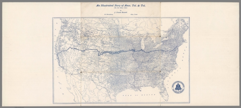
Author
Howell, J. Frank
Full Title
(Transcontinental line) : An illustrated story of Amn. Tel. & Tel. (on the other side) by J. Frank Howell, 52 Broadway, New York.
List No
14040.001
Note
Map of the United States showing the "Transcontinental Line" spanning the country from New York City to Los Angeles. Printed with blue ink. Includes seal for American Telephone & Telegraph Co. Map 22 x 35 cm, on sheet 27 x 61 cm.
Author
New England Railway Publishing Company
Full Title
ABC, The pathfinder railway guide map : Western section. Issued by the New England Railway Publishing Company, 67 Federal St., Boston, Mass. Copyright, 1902.
List No
14042.000
Note
Map of the United States showing railroads in red lines, with stations. Map 70 x 108 cm, on sheet 77 x 115 cm. With 5 insets: Alaska -- Yellowstone Park -- Philippine Islands -- Guam -- Hawaiian Islands.
Author
[Bauer, Hubert A. (Hubert Anton), 1886-, American Airlines Inc., News Map of the Week, Inc.]
Full Title
World News of the Week : Monday, Feb. 12, 1951. Covering period Feb. 2 to Feb. 8. Volume 13, No. 24. Published and copyrighted (weekly), 1951, by News Map of the Week, Inc., 1512 Orleans Street, Chicago, Illinois. Published in two sections : Section one. Lithographed in U. S. A. Cartographer, H. A. Bauer. Base map copyrighted by American Airlines, Inc.
List No
14223.000
Note
Lithographed world map, in color. Shows political boundaries and significant events from February 2 to 8, 1951. Relief illustrated with hachures. "This map - an azimuthal projection focused upon the geographical center of the United States - was developed by air-age education research of American Airlines, Inc." Includes information on bauxite across the globe, with explanation, as well as descriptive text throughout, e.g.: Gold Coast : 120,000 tons. Map indexed according to historical notes beneath map. With inset map: The rail strike. Also, with three diagrams: The rail strike -- Deaths from accidents -- Highlights of the administration's $10,000,000,000 tax program. Map is 61 x 64 cm, on sheet 89 x 120 cm, folded to 31 x 23 cm.
Author
[Geological Survey (U.S.), Shaw, W. James II., United States. Army]
Full Title
Major rail network : 1966 / W. James Shaw, II, U. S. Department of the Army, 1966.
List No
14359.174
Note
Transportation map representing the United States, featuring the geographic locations of the major railway network, including primary and secondary railroads, as of 1966. Map also shows political boundaries, time zones, topography, bodies of water, drainage, coastlines and islands. Relief shown with shading. Includes a legend, as well as a bar scale and scale statement. Presented with Albers Equal Area Projection. With two inset maps: Principal islands of Hawaii -- Alaska. Colored lithograph. Map is 43 x 66 cm, on double sheet 49 x 71 cm. Appears in Special subject maps section, subsection Economic : Transportation.
Author
Whitney, Asa
Full Title
No. 2 ( A map of North America showing possible rail routes across the continent.) Miller's Lith. 102 Broadway, N.Y. "N.B. this map shews very nealy the sphere of the Globe, and the line from Baltimore and the line from Panama to Puget Sound, would be the air line route. (to accompany) A Project For A Railroad To The Pacific. By Asa Whitney, of New York.
List No
1466.005
Note
Untitled map of North America showing possible rail routes across the continent. Includes notes on Northern route and Southern route, The Galveston route and St. Louis routes, with distances in miles from place to place. Relief shown by hachures. Title supplied by cataloger.
Author
United States. Central Intelligence Agency
Full Title
(Text Page to) Railroads. (to accompany) People's Republic of China - Atlas. November 1971. Central Intelligence Agency.
List No
1507.024
Note
Includes two color map of the United States and China. with three black and white views of railroad construction.
Full Title
372. Railroad systems of the United States: 1890. Julius Bien & Co. Lith., N.Y. (1898)
List No
1873.060
Note
Color lithographed map.
Author
Bradford, Thomas G.
Full Title
United States, exhibiting the railroads & canals. (to accompany) A Comprehensive Atlas, Geographical, Historical & Commercial. By T.G. Bradford. Boston: American Stationers' Company. Entered ... 1835, by Thos. G. Bradford ... Massachusetts.
List No
2120.064
Note
Color map. Shows administrative boundaries, railroads, canals, Indian territories, rivers, etc. Relief shown pictorially. Prime meridian is Washington.
Author
Bradford, Thomas G.
Full Title
(Text Page to) Railroads and canals. (to accompany) A Comprehensive Atlas, Geographical, Historical & Commercial. By T.G. Bradford. Boston: American Stationers' Company. Entered ... 1835, by Thos. G. Bradford ... Massachusetts.
List No
2120.065
Note
Text to the railroads and canals in the United States and other countries.
Author
Warren, Gouverneur Kemble, 1830-1882
Full Title
Map Of The Territory Of The United States From The Mississippi To The Pacific Ocean Ordered by the Hon. Jeff'n Davis, Secretary Of War To accompany the Reports of the Explorations For A Railroad Route ... Compiled from authorized explorations and other reliable data by Lieut. G.K. Warren, Topl. Engrs. In the Office of Pacific R.R. Surveys, War Dep. under the direction of Bvt. Maj. W.H. Emory and Capt. A.A. Humphreys, Topl. Engrs. 1855. Engr. by Selmar Siebert.
List No
2289.000
Note
Very early issue of Warren's Pacific Railroad general map of the U.S. When the Pacific Railway Survey reports were published in 1855, the large Warren map of the U.S. was not completed and a smaller map was issued with a note by Warren that the larger map would soon be ready for publication. This issue of the map is dated 1855 only, unlike the final issue which was dated 1854-5-6-7 (see our #0693). Also, the list of authorities here is shorter than the later issue and has no dates later than 1855. Most importantly, this issue has major areas blank that are filled in the final issue. Various routes are drawn in ms on the map, in red and blue lines, all proceeding from points in the Midwest to the west coast, as well as some north - south routes. Also, a red line is drawn from east to west next to the 38th parallel. We think these are the trails used by travelers, perhaps a few years later, but we can't be sure. There is another early issue of this map that is between this 1855 issue and the version published with the final reports - it is dated 1857, has fewer "blank" areas that this and has more and later dated authorities (see WH copy).
Author
Poussin, Guillaume Tell, 1794-1876
Full Title
Carte generale des Etats-Unis d'Amerique. Avec l'indication de la partie navigable de chaque riviere ainsi que le trace des canaux de navigation et chemins de fer tant executes qu'en execution. Dressee par le Major Poussin, pour servir a son ouvrage sur les travaux d'ameliorations interieures executes ou projetes par le gouvernement des Etats-Unis de 1824 a 1831. 1834.
List No
2329.001
Note
Engraved map showing settlements, Indian villages, post roads, etc. Includes inset of southern Florida. Prime meridian: [Washington]
Author
Powell, John Wesley, 1834-1902.
Full Title
Map of the United States exhibiting the grants of lands made by the general government to aid in the construction of railroads and wagon roads. For explanation see chapter on "L̀and grants in aid of internal improvements". Julius Bien, Lithographer. (at head of title) Department of the Interior, U.S. Geographical and Geological Survey of the Rocky Mountain region, J.W. Powell in charge. (on upper margin) To accompany report on the Lands of the Arid Region of the U.S.
List No
2347.010
Note
Color map. Shows land grant s to railroads and wagon roads, and limit to grants. "The base chart was engraved for the Statistical atlas of the United States".
Author
Powell, John Wesley, 1834-1902.
Full Title
Rain chart of the United States : showing by isohyetal lines the distribution of the mean annual precipitation in rain and melted snow. This is a copy of the chart constructed for the Smithsonian Institution in 1868 by Charles A Schott ... Julius Bien, Lithographer. (at head of title) Department of the Interior, U.S. Geographical and Geological Survey of the Rocky Mountain region, J.W. Powell in charge. (on upper margin) To accompany report on the Lands of the Arid Region of the U.S.
List No
2347.011
Note
Color map. Showing isothermal lines. Includes explanation. "The base chart was engraved for the Statistical atlas of the United States".
Author
Tanner, Henry S.
Full Title
(Covers to) The American Traveller; Or Guide Through the United States. Containing Brief Notices of the Several States, Cities, Principal Towns ... Alphabetically arranged, Eighth Edition. By H.S. Tanner. Philadelphia: Published by H. Tanner, Jr. New York: T.R. Tanner. 1842. (on verso) Entered ... 1839, by H.S. Tanner ... Pennsylvania. With direct References to the accompanying Map "The Travellers Guide or Map of the Roads, Canals, and Railways of the United States. With the distances from place to place by H.S. Tanner.
List No
2528.001
Note
8th edition, published by H. Tanner Jr. in Philadelphia and T.R. Tanner in New York, both presumably H. Tanner senior's sons. The large map appears unchanged from the 1840 edition. Large outline color map bound in back entitled, "The Travellers Guide or Map of the Roads, Canals & Rail Roads of the United States, With the distances from place to place by H.S. Tanner." At bottom of map, "Entered ... 1834, by H.S. Tanner ... Pennsylvania." Book bound with linen and with title embossed on cover, "Tanner's American Traveller or Guide through the United States with Maps, Plans &c. 1842."
Author
Tanner, Henry S.
Full Title
(Title Page to) The American Traveller; Or Guide Through the United States. Containing Brief Notices of the Several States, Cities, Principal Towns ... Alphabetically arranged, Eighth Edition. By H.S. Tanner. Philadelphia: Published by H. Tanner, Jr. New York: T.R. Tanner. 1842. (on verso) Entered ... 1839, by H.S. Tanner ... Pennsylvania. With direct References to the accompanying Map "The Travellers Guide or Map of the Roads, Canals, and Railways of the United States. With the distances from place to place by H.S. Tanner.
List No
2528.002
Note
8th edition, published by H. Tanner Jr. in Philadelphia and T.R. Tanner in New York, both presumably H. Tanner senior's sons. The large map appears unchanged from the 1840 edition. Large outline color map bound in back entitled, "The Travellers Guide or Map of the Roads, Canals & Rail Roads of the United States, With the distances from place to place by H.S. Tanner." At bottom of map, "Entered ... 1834, by H.S. Tanner ... Pennsylvania." Book bound with linen and with title embossed on cover, "Tanner's American Traveller or Guide through the United States with Maps, Plans &c. 1842."
Author
Tanner, Henry S.
Full Title
The Travellers Guide or Map of the Roads, Canals, and Railways of the United States. With the Distances from Place to Place by H.S. Tanner. (with inset 8 inset maps). (with the accompanying guide) The American Traveller; Or Guide Through the United States. Containing Brief Notices of the Several States, Cities, Principal Towns ... Alphabetically arranged, Eighth Edition. By H.S. Tanner. Philadelphia: Published by H. Tanner, Jr. New York: T.R. Tanner. 1842. (on verso) Entered ... 1839, by H.S. Tanner ... Pennsylvania.
List No
2528.003
Note
8th edition, published by H. Tanner Jr. in Philadelphia and T.R. Tanner in New York, both presumably H. Tanner senior's sons. The large map appears unchanged from the 1840 edition. Large outline color map bound in back entitled, "The Travellers Guide or Map of the Roads, Canals & Rail Roads of the United States, With the distances from place to place by H.S. Tanner." At bottom of map, "Entered ... 1834, by H.S. Tanner ... Pennsylvania." Book bound with linen and with title embossed on cover, "Tanner's American Traveller or Guide through the United States with Maps, Plans &c. 1842."
Author
Tanner, Henry S.
Full Title
Baltimore
List No
2528.004
Note
8th edition, published by H. Tanner Jr. in Philadelphia and T.R. Tanner in New York, both presumably H. Tanner senior's sons. The large map appears unchanged from the 1840 edition. Large outline color map bound in back entitled, "The Travellers Guide or Map of the Roads, Canals & Rail Roads of the United States, With the distances from place to place by H.S. Tanner." At bottom of map, "Entered ... 1834, by H.S. Tanner ... Pennsylvania." Book bound with linen and with title embossed on cover, "Tanner's American Traveller or Guide through the United States with Maps, Plans &c. 1842."
Author
Tanner, Henry S.
Full Title
Boston
List No
2528.005
Note
8th edition, published by H. Tanner Jr. in Philadelphia and T.R. Tanner in New York, both presumably H. Tanner senior's sons. The large map appears unchanged from the 1840 edition. Large outline color map bound in back entitled, "The Travellers Guide or Map of the Roads, Canals & Rail Roads of the United States, With the distances from place to place by H.S. Tanner." At bottom of map, "Entered ... 1834, by H.S. Tanner ... Pennsylvania." Book bound with linen and with title embossed on cover, "Tanner's American Traveller or Guide through the United States with Maps, Plans &c. 1842."
Author
Tanner, Henry S.
Full Title
New York
List No
2528.006
Note
8th edition, published by H. Tanner Jr. in Philadelphia and T.R. Tanner in New York, both presumably H. Tanner senior's sons. The large map appears unchanged from the 1840 edition. Large outline color map bound in back entitled, "The Travellers Guide or Map of the Roads, Canals & Rail Roads of the United States, With the distances from place to place by H.S. Tanner." At bottom of map, "Entered ... 1834, by H.S. Tanner ... Pennsylvania." Book bound with linen and with title embossed on cover, "Tanner's American Traveller or Guide through the United States with Maps, Plans &c. 1842."
Author
Tanner, Henry S.
Full Title
Philadelphia and Environs
List No
2528.007
Note
8th edition, published by H. Tanner Jr. in Philadelphia and T.R. Tanner in New York, both presumably H. Tanner senior's sons. The large map appears unchanged from the 1840 edition. Large outline color map bound in back entitled, "The Travellers Guide or Map of the Roads, Canals & Rail Roads of the United States, With the distances from place to place by H.S. Tanner." At bottom of map, "Entered ... 1834, by H.S. Tanner ... Pennsylvania." Book bound with linen and with title embossed on cover, "Tanner's American Traveller or Guide through the United States with Maps, Plans &c. 1842."
Author
Tanner, Henry S.
Full Title
Manuscript Drawing
List No
2528.008
Note
8th edition, published by H. Tanner Jr. in Philadelphia and T.R. Tanner in New York, both presumably H. Tanner senior's sons. The large map appears unchanged from the 1840 edition. Large outline color map bound in back entitled, "The Travellers Guide or Map of the Roads, Canals & Rail Roads of the United States, With the distances from place to place by H.S. Tanner." At bottom of map, "Entered ... 1834, by H.S. Tanner ... Pennsylvania." Book bound with linen and with title embossed on cover, "Tanner's American Traveller or Guide through the United States with Maps, Plans &c. 1842."
Author
Watson, Gaylord
Full Title
(Covers to) Watson's New County and Railroad Map of the United States and the Dominion of Canada Compiled From the Latest Official Sources, 1874. Published by Gaylord Watson, 16 Beekman St., New York. Entered ... 1871, by Gaylord Watson ... Washington. (with) 5 inset maps: Routes of the Union, Central & Kansas Pacific Railroad; Vicinity of Boston; Vicinity of Philadelphia; Vicinity of New York; Lower Part of Florida.
List No
2540A
Note
5 inset maps, Vignette of Locomotive under title. Shows the route of the "Proposed Atlantic and Great Western Canal." Also an inset of the Union, Central & Kansas Pacific Railroad. Population tables, statistics, etc. Highly detailed map showing railroads and counties and cities in the eastern part of the U.S. and Canada. Has "United States" on the cover and is the companion map to the Map of the Western States... with "Territories" (see #2539.000) on its cover. Copyright date is 1871. For some reason, Modelski does not list all these early Watson maps, but only a few maps dated 1874 and later; perhaps Watson did not deposit all his maps with the LOC.
Author
Watson, Gaylord
Full Title
Watson's New County and Railroad Map of the United States and the Dominion of Canada Compiled From the Latest Official Sources, 1874. Published by Gaylord Watson, 16 Beekman St., New York. Entered ... 1871, by Gaylord Watson ... Washington. (with) 5 inset maps: Routes of the Union, Central & Kansas Pacific Railroad; Vicinity of Boston; Vicinity of Philadelphia; Vicinity of New York; Lower Part of Florida.
List No
2540.001
Note
5 inset maps, Vignette of Locomotive under title. Shows the route of the "Proposed Atlantic and Great Western Canal." Also an inset of the Union, Central & Kansas Pacific Railroad. Population tables, statistics, etc. Highly detailed map showing railroads and counties and cities in the eastern part of the U.S. and Canada. Has "United States" on the cover and is the companion map to the Map of the Western States... with "Territories" (see #2539.000) on its cover. Copyright date is 1871. For some reason, Modelski does not list all these early Watson maps, but only a few maps dated 1874 and later; perhaps Watson did not deposit all his maps with the LOC.
Author
Lloyd, J.T.
Full Title
(Covers to) Lloyd's New Map of the United States The Canadas And New Brunswick From the latest Surveys Showing Every Railroad & Station Finished to June 1863 And The Atlantic And Gulf Coasts ... 1863 ... Address J.T. Lloyd, No. 164 Broadway, New York, and 1 Strand, London, England. Entered ... 1863, by J.T. Lloyd ... New York.
List No
2591.001
Note
1st edition was issued in June, 1862. Interesting note on his competitor, H.H. Lloyd. Shows U.S. west to the 103 meridian. Dated 1864 on the cover. Has a catalogue of Lloyd's works. Map is full color by county, folded into embossed light brown cloth covers 18x11.5 with "Lloyd's New-Map Of The United States And Canadas. 1864" in gold.
Author
Lloyd, J.T.
Full Title
Lloyd's New Map of the United States The Canadas And New Brunswick From the latest Surveys Showing Every Railroad & Station Finished to June 1863 And The Atlantic And Gulf Coasts ... 1863 ... Address J.T. Lloyd, No. 164 Broadway, New York, and 1 Strand, London, England. Entered ... 1863, by J.T. Lloyd ... New York.
List No
2591.002
Note
1st edition was issued in June, 1862. Interesting note on his competitor, H.H. Lloyd. Shows U.S. west to the 103 meridian. Dated 1864 on the cover. Has a catalogue of Lloyd's works. Map is full color by county, folded into embossed light brown cloth covers 18x11.5 with "Lloyd's New-Map Of The United States And Canadas. 1864" in gold. Prime meridian is Greenwich. Relief shown by hacures.
Author
Perris, William
Full Title
(Covers to) A New And Complete Rail Road Map Of The United States, Compiled from Reliable Sources by William Perris, C.E. & Surveyor, New York. Presented by the Home Insurance Company of New York ... Office Nos. 112 & 114 Broadway ... Korff Brothers Practical Lithographers 54 William St. New York.
List No
2617.001
Note
Presented by the Home Insurance Co., New York. Elaborate cartouche with an advertisement for the Home Insurance Co. in the middle. Shows railroads west to the 97th meridian. Full color by state. Folded into textured brown cloth covers 15x9.5 with "Presented By The Home Insurance Company. Of New-York. Cash Capital $600,000. Surplus over $250,000. 1858" stamped in gilt.
Author
Perris, William
Full Title
A New And Complete Rail Road Map Of The United States, Compiled from Reliable Sources by William Perris, C.E. & Surveyor, New York. Presented by the Home Insurance Company of New York ... Office Nos. 112 & 114 Broadway ... Korff Brothers Practical Lithographers 54 William St. New York.
List No
2617.002
Note
Presented by the Home Insurance Co., New York. Elaborate cartouche with an advertisement for the Home Insurance Co. in the middle. Shows railroads west to the 97th meridian. Full color by state. Folded into textured brown cloth covers 15x9.5 with "Presented By The Home Insurance Company. Of New-York. Cash Capital $600,000. Surplus over $250,000. 1858" stamped in gilt.
Author
Bradford, Thomas G.
Full Title
United States, exhibiting the railroads & canals. (to accompany) A Comprehensive Atlas, Geographical, Historical & Commercial. By T.G. Bradford. William D. Ticknor, Boston. Wiley & Long, New-York. Entered ... 1835, by Thos. G. Bradford ... Massachusetts.
List No
2643.064
Note
Outline color map by administrative boundaries. Shows railroads, canals, Indian territories, rivers, etc. Relief shown pictorially. Prime meridian is Washington.
Author
[Freyhold, Edward, Warren, Gouverneur Kemble, 1830-1882]
Full Title
Map Of The Territory Of The United States From The Mississippi To The Pacific Ocean; Ordered by the Hon. Jeff'n Davis, Secretary Of War To accompany the Reports of the Explorations For A Railroad Route ... Compiled from authorized explorations and other reliable data by Lieut. G.K. Warren, Topl. Engrs. In the Office of Pacific R.R. Surveys, War Dep. under the direction of Bvt. Maj. W.H. Emory, Topl. Engrs. in 1854 and of Capt. A.A. Humphreys, Topl. Engrs. 1854-5-6-7-8. Drawn by E. Freyhold. Engr. on Stone by J. Bien, 60 Fulton St. N.Y.
List No
2750.000
Note
2nd 1858 edition, adds Ives Grand Canyon expedition. Also adds information from Warren's third expedition. Schubert says there was an earlier 1858 edition that filled in information in Oregon but did not include the Ives information. Schubert also quotes a letter from Warren stating that this edition was sent to the printer in 1859. Freyhold's name appears on the title for the first time. It is dropped in the next (1867) edition and then reappears in the 1868 edition. Rare - apparently there is only one other copy of this map - in the Millard Fillmore Map Collection in the LOC (see Stephenson article in Map Collector No. 12). This copy came from the Bancroft Library as a duplicate - perhaps they thought it was a duplicate of the 1857 edition. With brown wood side rollers. Map is without color and mounted on linen.
Author
Goldthwait, J.H.
Full Title
(Covers to) Goldthwait's Map Of The United States, British Provinces, Mexico, Central America, W. India Is. &c. Exhibiting The Railroads ... by J.H. Goldthwait. Published by D. Chester, 119 & 121 Nassau St. New York. Entered ... 1861 by J.H. Goldthwait ... New York. (inset) Great Rail Road Routes from the Middle Atlantic Ports To The Mississippi River by J.H. Goldthwait. (inset) Of The Railroads Of New England And Eastern N . York by J.H. Goldthwait.
List No
2762.001
Note
Important U.S. Railroad map; civil war references. Goldthwait did an early map of the Mississippi Valley in 1833 (see Karrow index), engraved for Johnson (large N.A. 1859) and Colton (County Map of N.A. 1864) and produced several beautiful railroad maps. Colton put out a later edition of this map (see Phillips 909). This map is extraordinary for its graphic clarity and elegance. Two inset maps show railroad routes in New England and the Mid West. The west is largely empty except for California where many towns are listed along with topographical features. Many lists of statistics are provided (showing population growth) as well as a list of the seceding southern states with dates of secession. Railroad routes are shown as single and double track, including the width of the gauge. Full color map, folded into textured brown cloth covers 14.5x9 with "Goldthwait's Map Of The United States & Canada" stamped in gilt. Relief shown by hachures.
Author
Goldthwait, J.H.
Full Title
Goldthwait's Map Of The United States, British Provinces, Mexico, Central America, W. India Is. &c. Exhibiting The Railroads ... by J.H. Goldthwait. Published by D. Chester, 119 & 121 Nassau St. New York. Entered ... 1861 by J.H. Goldthwait ... New York. (inset) Great Rail Road Routes from the Middle Atlantic Ports To The Mississippi River by J.H. Goldthwait. (inset) Of The Railroads Of New England And Eastern N . York by J.H. Goldthwait.
List No
2762.002
Note
Important U.S. Railroad map; civil war references. Goldthwait did an early map of the Mississippi Valley in 1833 (see Karrow index), engraved for Johnson (large N.A. 1859) and Colton (County Map of N.A. 1864) and produced several beautiful railroad maps. Colton put out a later edition of this map (see Phillips 909). This map is extraordinary for its graphic clarity and elegance. Two inset maps show railroad routes in New England and the Mid West. The west is largely empty except for California where many towns are listed along with topographical features. Many lists of statistics are provided (showing population growth) as well as a list of the seceding southern states with dates of secession. Railroad routes are shown as single and double track, including the width of the gauge. Full color map, folded into textured brown cloth covers 14.5x9 with "Goldthwait's Map Of The United States & Canada" stamped in gilt. Relief shown by hachures.
Author
[Mitchell, Samuel Augustus, Drake, Ira S.]
Full Title
(Covers to) Mitchell's New Traveller's Guide Through The United States, Containing The Principal Cities, Towns &c. ... Illustrated By An Accurate Map Of The United States. Philadelphia: Thomas, Cowperthwait & Co. 1849. (on verso) Entered ... 1848, by Thomas, Cowperthwait & Co. ... Pennsylvania. Stereotyped by J. Fagan. Printed by Smith & Peters. (with map) Mitchell's New Traveller's Guide Through The United States, Showing the Rail Roads, Canals, Stage Roads &c. ... Drawn and Engraved by Ira S. Drake. Philadelphia 1849 Published by Thomas, Cowperthwait & Co. Entered ... 1848, by Thomas, Cowperthwait, & Co. ... Pennsylvania. (with 5 inset maps).
List No
2766.001
Note
This is a major revision of the guide with an entirely new map by Ira S. Drake (about whom we find nothing) with five inset maps entitled - "Vicinity Of Niagara Falls", "Map Of The Copper Mine Region", "Map of the Gold and Quicksilver district of California", "Map of the Maritime and Overland Routes to California", and "Map Of New England Or Eastern States". The map emphasis on the California gold rush is clear, although the 128 pages of expanded text do not yet list routes to the gold fields, while they do add routes west from St. Louis and Independence. The main map is larger than the earlier Mitchell/Young maps, but shows roughly the same area on a somewhat larger scale. An "Advertisement" (actually a preface) dated Nov. 1, 1848, states: "The following work is similar in design to 'Mitchell's Traveller's Guide,' first published about twelve years ago, and which has been so extremely patronized, that it may be safely asserted no book of the kind ever printed in this country has met with so wide a circulation." Covers are black stamped leather with "Mitchell's New Traveller's Guide Through The United States" and a beautiful illustration of a steam boat and train stamped in gilt. Map is outline color. Catalogue of Thomas, Cowperthwait School Books included in the text.
Author
[Mitchell, Samuel Augustus, Drake, Ira S.]
Full Title
(Title Page to) Mitchell's New Traveller's Guide Through The United States, Containing The Principal Cities, Towns &c. ... Illustrated By An Accurate Map Of The United States. Philadelphia: Thomas, Cowperthwait & Co. 1849. (on verso) Entered ... 1848, by Thomas, Cowperthwait & Co. ... Pennsylvania. Stereotyped by J. Fagan. Printed by Smith & Peters. (with map) Mitchell's New Traveller's Guide Through The United States, Showing the Rail Roads, Canals, Stage Roads &c. ... Drawn and Engraved by Ira S. Drake. Philadelphia 1849 Published by Thomas, Cowperthwait & Co. Entered ... 1848, by Thomas, Cowperthwait, & Co. ... Pennsylvania. (with 5 inset maps).
List No
2766.002
Note
This is a major revision of the guide with an entirely new map by Ira S. Drake (about whom we find nothing) with five inset maps entitled - "Vicinity Of Niagara Falls", "Map Of The Copper Mine Region", "Map of the Gold and Quicksilver district of California", "Map of the Maritime and Overland Routes to California", and "Map Of New England Or Eastern States". The map emphasis on the California gold rush is clear, although the 128 pages of expanded text do not yet list routes to the gold fields, while they do add routes west from St. Louis and Independence. The main map is larger than the earlier Mitchell/Young maps, but shows roughly the same area on a somewhat larger scale. An "Advertisement" (actually a preface) dated Nov. 1, 1848, states: "The following work is similar in design to 'Mitchell's Traveller's Guide,' first published about twelve years ago, and which has been so extremely patronized, that it may be safely asserted no book of the kind ever printed in this country has met with so wide a circulation." Covers are black stamped leather with "Mitchell's New Traveller's Guide Through The United States" and a beautiful illustration of a steam boat and train stamped in gilt. Map is outline color. Catalogue of Thomas, Cowperthwait School Books included in the text.
Author
[Mitchell, Samuel Augustus, Drake, Ira S.]
Full Title
Mitchell's New Traveller's Guide Through The United States, Showing the Rail Roads, Canals, Stage Roads &c. ... Drawn and Engraved by Ira S. Drake. Philadelphia 1849 Published by Thomas, Cowperthwait & Co. Entered ... 1848, by Thomas, Cowperthwait, & Co. ... Pennsylvania. (with 5 inset maps). (with guide book) Mitchell's New Traveller's Guide Through The United States, Containing The Principal Cities, Towns &c. ... Illustrated By An Accurate Map Of The United States. Philadelphia: Thomas, Cowperthwait & Co. 1849. (on verso) Entered ... 1848, by Thomas, Cowperthwait & Co. ... Pennsylvania. Stereotyped by J. Fagan. Printed by Smith & Peters.
List No
2766.003
Note
This is a major revision of the guide with an entirely new map by Ira S. Drake (about whom we find nothing) with five inset maps entitled - "Vicinity Of Niagara Falls", "Map Of The Copper Mine Region", "Map of the Gold and Quicksilver district of California", "Map of the Maritime and Overland Routes to California", and "Map Of New England Or Eastern States". The map emphasis on the California gold rush is clear, although the 128 pages of expanded text do not yet list routes to the gold fields, while they do add routes west from St. Louis and Independence. The main map is larger than the earlier Mitchell/Young maps, but shows roughly the same area on a somewhat larger scale. An "Advertisement" (actually a preface) dated Nov. 1, 1848, states: "The following work is similar in design to 'Mitchell's Traveller's Guide,' first published about twelve years ago, and which has been so extremely patronized, that it may be safely asserted no book of the kind ever printed in this country has met with so wide a circulation." Covers are black stamped leather with "Mitchell's New Traveller's Guide Through The United States" and a beautiful illustration of a steam boat and train stamped in gilt. Map is outline color. Catalogue of Thomas, Cowperthwait School Books included in the text. Prime meridian is Washington D.C.
Author
Cram, George Franklin
Full Title
Map of the United States of America. (inset) Alaska.
List No
2809.108
Note
Relief shown by hachures. Prime meridians Washington D.C. and Greenwich.
Author
Lloyd, J. T.
Full Title
Lloyd's New Map of the United States The Canadas and New Brunswick From The Latest Surveys Showing Every Railroad & Station Finished to June 1862... 1866. (On verso: ) Lloyd's Topographical Railway Map of North America or the United States Continent in 1900....
List No
2859.002
Note
Two sided wall map -see 1866 copy. On this side, in addition to the U.S. map, there are insets of major cities and their rail lines. Similar to the 1866 edition, but some changes - on the verso North America map, adds inset of South America, the Pacific Railway route has been changed to go north of Salt Lake, some of the ads on the steamship routes have been deleted.
Author
Mitchell, Samuel Augustus
Full Title
Mitchell's Map Of The United States Showing the Principal Travelling, Turnpike and Common Roads ... Philadelphia: Published By S. Augustus Mitchell. 1835. Sold by Mitchell & Hinman No. 6 North Fifth Street. Entered ... 1835, by S. Augustus Mitchell... Pennsylvania. (with 8 inset maps). (with text) Mitchell's Compendium Of The Internal Improvements Of The United States; Comprising General Notices Of All The Most Important Canals and Rail-Roads... Philadelphia: Published By Mitchell & Hinman, No. 6 North-Fifth Street. 1835. (on verso) Entered ... 1835, by Mitchell & Hinman ... Pennsylvania. Stereotyped by John Fagan ... Philadelphia.
List No
2869.003
Note
1st edition. This guide is scarcer than Mitchell's Traveller's Guide. The outline color map is very similar to the Traveller's Guide Map - it is probably from the same plate, but covers slightly more area, has eight inset maps (the Traveller's map drops the Hartford /New Haven inset and adds two - Niagara Falls and New Orleans) instead of nine, and has a table of distances below the title. The 84 page text in this guide is a descriptive listing of Canals, Railroads, etc.; the Traveller's Guide text functions as a route book and was certainly more generally useful and had many more editions. There was only one other edition of this Compendium, in 1838 (see our #521). The map was issued separately in 1839 (see our #4950) and a printing on silk was issued in 1835 (see our #4544). Book is bound into black leather covers with "Mitchell's Compendium Of Canals & Railroads" and a decorative border stamped in gilt. Four page catalogue of Mitchell's maps. Prime meridians are Washington D.C. and Greenwich.
Author
Everts, L.H.
Full Title
Rail Road Map of the United States. Prepared Expecially for Evert's Illustrated Historical Atlas by H.H. Lloyd & Co..21 John St., N.Y.
List No
2870.005
Author
Tanner, Henry S.
Full Title
(Covers to) The Traveller's Guide Or Map Of The Roads, Canals & Rail Roads of the United States With the distances from place to place. By H.S. Tanner 1846. Published by H.S Tanner, 144 Chestnut St. Philadelphia. Entered ... 1844, by H.S. Tanner ... Pennsylvania. (with 11 inset maps).
List No
2985.001
Note
Separate issue of the map normally found with the guide. Inset maps show the environs of Albany Saratoga, Niagara Falls, Quebec, Providence, Boston, Richmond, New York, Charleston, Baltimore and Washington, Washington D.C., and Philadelphia. Full color by state. Brown cloth covers 13.5x8.5 are stamped "U. States" in gold.
Author
Tanner, Henry S.
Full Title
The Traveller's Guide Or Map Of The Roads, Canals & Rail Roads of the United States With the distances from place to place. By H.S. Tanner 1846. Published by H.S Tanner, 144 Chestnut St. Philadelphia. Entered ... 1844, by H.S. Tanner ... Pennsylvania. (with 11 inset maps).
List No
2985.002
Note
Separate issue of the map normally found with the guide. Inset maps show the environs of Albany Saratoga, Niagara Falls, Quebec, Providence, Boston, Richmond, New York, Charleston, Baltimore and Washington, Washington D.C., and Philadelphia. Full color by state. Brown cloth covers 13.5x8.5 are stamped "U. States" in gold.
Author
Rand McNally and Company
Full Title
Rand McNally & Co.'s New Railroad Junction Point And County Map Of The Eastern & Middle States. Prepared from the Latest Government Surveys, and Verified by the Working Time Tables of the Various Railroads. Drawn, Engraved, Printed, Colored By Hand And Published By Rand McNally & Co., Chicago. The Railroads on this Map are bought up to date of September 1885. Copyright, 1882, By Rand, McNally & Co. (inset) General Map Of The United States Of America Showing The Relative Geographical Position Of The Several States And Territories.
List No
3117.000
Note
Copyright 1882. Inset map of the United States. 1 of six sections. Very large map of the northeast and middle coastal areas, which, although complete by itself, was also part of a twelve sheet map in six parts (two sheets to each part) that extended west to the 105th parallel and south to Florida and measured 10x15 feet (see Modelski). All the existing railroads are shown in great detail at a scale of six miles to one inch. Because of it great size, the map was hand colored. Dissected into 49 sections and backed with linen. See our 5802.000 for a related map. Folds into dark blue cloth covered boards 31x23.
Author
[Lubrecht, Charles, Rosa, R.]
Full Title
(Covers to) The American Continent. Topographical and railroad map of the United States, British Possessions, West Indies, Mexico and Central America. Compiled from the best authorities, by R. Rosa, late Col. 46th Regt. N.Y.S. Vol. Published by Ch. Lubrecht & Co., 12 Frankfort Street, New York. 1864. Agents For Great Britain: Bacon & Co., 48 Paternoster Row, London, England. For Germany, Switzerland And Italy: Fr. Volkmar, Leipsic. Lubrecht & Co., Stuttgart. Revised Edition. Entered ... 1864, by Ch. Lubrecht & Co. ... New York. (with) Central America.
List No
3127A
Note
1st edition. 2nd edition was1865, another edition in 1869 (Karrow 1-1683). German edition published in 1864. (Karrow 1-1655). Inset of Central America, text on top of map describing British American Possessions, Time Tables, and U.S. Census for 1860. We can find no earlier edition of this map, so the "Revised Edition" is puzzling. Lubrecht lists three foreign publishers for this map: Bacon in London, Volkmar in Leipsic, and Lubrecht & Co. in Stuttgart. An edition in German is described in Karrow. Later, this map became the more elaborate 1871 "American Union Railroad Map of the United States..." by Hassis & Lubrecht, also published by D.L. Gurnsey (see our copy, WH's copy, and Heaston Cat. 19 for a reproduction). The Proposed transcontinental railroad is shown going south of Salt Lake City, Wyoming is still part of Dakota, and a Proposed Southern Pacific Railroad runs from Fort Smith to Sacramento. Full color by state. Map is dissected into 24 sections and mounted on linen. Folded into black paper covered boards 24.5x21 with "The American Continent" stamped in gilt. Relief shown by hachures.
Author
[Lubrecht, Charles, Rosa, R.]
Full Title
The American Continent. Topographical and railroad map of the United States, British Possessions, West Indies, Mexico and Central America. Compiled from the best authorities, by R. Rosa, late Col. 46th Regt. N.Y.S. Vol. Published by Ch. Lubrecht & Co., 12 Frankfort Street, New York. 1864. Agents For Great Britain: Bacon & Co., 48 Paternoster Row, London, England. For Germany, Switzerland And Italy: Fr. Volkmar, Leipsic. Lubrecht & Co., Stuttgart. Revised Edition. Entered ... 1864, by Ch. Lubrecht & Co. ... New York. (with) Central America.
List No
3127.001
Note
1st edition. 2nd edition was1865, another edition in 1869 (Karrow 1-1683). German edition published in 1864. (Karrow 1-1655). Inset of Central America, text on top of map describing British American Possessions, Time Tables, and U.S. Census for 1860. We can find no earlier edition of this map, so the "Revised Edition" is puzzling. Lubrecht lists three foreign publishers for this map: Bacon in London, Volkmar in Leipsic, and Lubrecht & Co. in Stuttgart. An edition in German is described in Karrow. Later, this map became the more elaborate 1871 "American Union Railroad Map of the United States..." by Hassis & Lubrecht, also published by D.L. Gurnsey (see our copy, WH's copy, and Heaston Cat. 19 for a reproduction). The Proposed transcontinental railroad is shown going south of Salt Lake City, Wyoming is still part of Dakota, and a Proposed Southern Pacific Railroad runs from Fort Smith to Sacramento. Full color by state. Map is dissected into 24 sections and mounted on linen. Folded into black paper covered boards 24.5x21 with "The American Continent" stamped in gilt. Relief shown by hachures.
Author
Southern Pacific Company
Full Title
(Covers to:) California, Texas, Mexico And Arizona Southern Pacific Co. "Sunset route" from New Orleans to the Pacific Coast ... January, 1892. American Bank Note Co., N.Y.
List No
3139A
Note
Self wrapper cover in color, illustrated.
Author
Southern Pacific Company
Full Title
California, Texas, Mexico And Arizona Southern Pacific Co. "Sunset route" from New Orleans to the Pacific Coast ... January, 1892. American Bank Note Co., N.Y.
List No
3139B
Note
Timetables and travel information (20 p.) including self wrapper cover in color, illustrated. Folded to 21 x 10 cm.
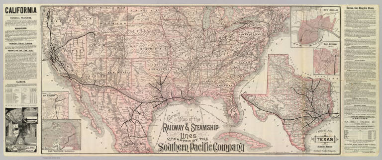
Author
Southern Pacific Company
Full Title
Correct map of the railway & steamship lines operated by the Southern Pacific Company [United States and Mexico]. Poole Bros., Map Engravers, Chicago. (inset) County map of Texas showing the Atlantic System of the Southern Pacific Company. (inset) San Francisco, California. (inset) Los Angeles, California. (inset) New Orleans. (inset) San Antonio, Texas.
List No
3139.001
Note
Col. map with 5 insets. Relief shown by hachures. Shows connecting steamship routes from New York to New Orleans. Text descriptions of California and Texas. Interior view of Sleeping Car.
|