|
Author
Cram, George Franklin, 1841-1928
Full Title
(Composite Map to) Western half of Pennsylvania. -- Eastern half of Pennsylvania. 1899, by Geo. F. Cram.
List No
14372.036
Note
Composite map of Pennsylvania (western and eastern halves). Shows political boundaries, counties, towns, railroads, steamship lines, topography, bodies of water, drainage, coastlines and islands. Relief shown with hachures. Includes keys with explanations, latitudinal and longitudinal lines, as well as bar scales given in miles. With alphanumeric grid corresponding to "Index of Pennsylvania" on pages 45-55, 58-61 and 64-67. Colored lithograph. Together, maps are 54 x 85 cm, on two double sheets 67 x 90 cm. "Index of maps" and "Index of cities" in margins, providing navigation for atlas as a whole.
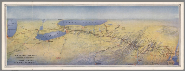
Author
Lackawanna Railroad
Full Title
Lackawanna Railroad. The Road of Anthracite. Through Car Routes New York to Chicago.
List No
10610.003
Author
Leahy, J.F.
Full Title
(Index to) Leahy's Hotel Guide and Railway Distance Maps. Pennsylvania.
List No
0425.104
Note
Alphabetical index list of the Hotels of the town with the number of rooms of each, their rates per day and the population of the town. Includes population of the state, Explanation of abbreviation of the railroad of the state, and advertisement.
Author
Leahy, J.F.
Full Title
Leahy's Hotel Guide and Railway Distance Map of the State of Pennsylvania. Published by American Hotel Register Company. Leahy Build., 228-234 W. Ontario St., Chicago, Ill. Copyrighted by J.F. Leahy, Jan., 1934.
List No
0425.105
Note
Map printed without color. Includes name of the railroad entering the town, and distance between towns.
Author
Leahy, J.F.
Full Title
(Index to) Leahy's Hotel Guide and Railway Distance Maps. Pennsylvania.
List No
0425.106
Note
Alphabetical index list of the Hotels of the town with the number of rooms of each, their rates per day and the population of the town. Includes population of the state, Explanation of abbreviation of the railroad of the state, and advertisement.
Author
Leahy, J.F.
Full Title
Leahy's Hotel Guide and Railway Distance Map of the State of Pennsylvania. Published by American Hotel Register Company. Leahy Build., 228-234 W. Ontario St., Chicago, Ill. Copyrighted by J.F. Leahy, Jan., 1934.
List No
0425.107
Note
Map printed without color. Includes name of the railroad entering the town, and distance between towns.
Author
Leahy, J.F.
Full Title
(Index to) Leahy's Hotel Guide and Railway Distance Maps. Pennsylvania.
List No
0425.108
Note
Pennsylvania and South Carolina alphabetical index list of the Hotels of the town with the number of rooms of each, their rates per day and the population of the town. Includes population of the states, Explanation of abbreviation of the railroad of the state, and advertisement.
Author
Tanner, Henry S.
Full Title
A new map of Pennsylvania with its canals, roads & distances from place to place along the stage roads. Published by H. S. tanner. Engraved by W. Brose, Philadelphia. Entered ... 1840, by T.R. Tanner ... Pennsylvania. (inset) Profile of the Pennsylvania Canal, and Columbia railroad.
List No
0979.004
Note
Maps show canals and roads in color with distances, folded into brown cloth covered boards. With explanation, note and table of steam boat routes to various places. Relief shown by hachures. Prime meridian is Washington.
Author
Tanner, Henry S.
Full Title
Florida Canal ; Morris Canal N. J. ; Union Canal Pa. ; Schuylkill Navigation Penn. ; Profile of the Pennsylvania Canal. (with inset profile) Columbia railroad Pa. (to accompany) A Description of the Canals and Railroads of the United States.
List No
0979.006
Note
Six profiles on one page.
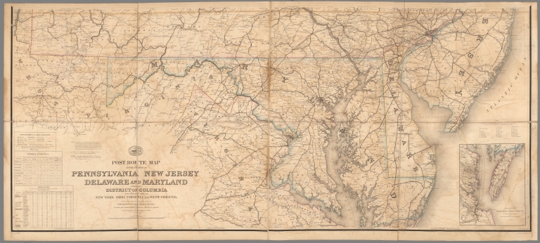
Author
United States. Post Office Department
Full Title
Upper Part Post Route Map of the States of Pennsylvania, New Jersey, Delaware, Maryland and of the District of Columbia.
List No
10436.002
Note
Updated to 1879 from 1869. 8 panels.
Author
United States. Post Office Department
Full Title
Lower Part Post Route Map of the States of Pennsylvania, New Jersey, Delaware, Maryland and of the District of Columbia.
List No
10436.004
Note
Updated to 1879 from 1869. 8 panels.
Author
United States. Post Office Department
Full Title
(Composite Map) Post Route Map of the States of Pennsylvania, New Jersey, Delaware, Maryland and of the District of Columbia.
List No
10436.005
Note
Updated to 1879 from 1869. 8 panels.
Author
Gray, Frank Arnold
Full Title
Railway map of the state of Pennsylvania, 1872. Drawn by F.A. Gray. (Published by Stedman, Brown & Lyon, Philadelphia)
List No
1155.005
Note
Col. lithographed map. Shows settlements, counties, railroads (completed and proposed), and canals.
Author
Cram, George Franklin, 1841-1928
Full Title
Western half of Pennsylvania. 1899, by Geo. F. Cram.
List No
14372.032
Note
Map of Pennsylvania (western half). Shows political boundaries, counties, towns, railroads, steamship lines, topography, bodies of water, drainage, coastlines and islands. Relief shown with hachures. Includes key with explanation, latitudinal and longitudinal lines, as well as a bar scale given in miles. With alphanumeric grid corresponding to "Index of Pennsylvania" on pages 45-55, 58-61 and 64-67. Colored lithograph. Map is 54 x 42 cm, on double sheet 67 x 45 cm. "Index of maps" and "Index of cities" in margins, providing navigation for atlas as a whole. Eastern half of map follows on pages 62-63.
Author
Cram, George Franklin, 1841-1928
Full Title
Eastern half of Pennsylvania. 1899, by Geo. F. Cram.
List No
14372.035
Note
Map of Pennsylvania (eastern half). Shows political boundaries, counties, towns, railroads, steamship lines, topography, bodies of water, drainage, coastlines and islands. Relief shown with hachures. Includes key with explanation, latitudinal and longitudinal lines, as well as a bar scale given in miles. With alphanumeric grid corresponding to "Index of Pennsylvania" on pages 45-55, 58-61 and 64-67. Colored lithograph. Map is 54 x 43 cm, on double sheet 67 x 45 cm. "Index of maps" and "Index of cities" in margins, providing navigation for atlas as a whole. Western half of map precedes on pages 56-57.
Author
Cram, George Franklin, 1841-1928
Full Title
Pennsylvania. 1899, by Geo. F. Cram.
List No
14372.039
Note
Map of Pennsylvania. Shows political boundaries, counties, towns, railroads, steamship lines, topography, bodies of water, drainage, coastlines and islands. Relief shown with hachures. Includes key with explanation, latitudinal and longitudinal lines, as well as a bar scale given in miles. With alphanumeric grid corresponding to "Index of Pennsylvania" on pages 45-55, 58-61 and 64-67. Colored lithograph. Map is 40 x 55 cm, on double sheet 45 x 67 cm. "Index of maps" and "Index of cities" in margins, providing navigation for atlas as a whole.
Author
Cram, George Franklin
Full Title
Western Half of Pennsylvania.
List No
2809.012
Note
Locations of banking towns shown by red circles. Railroads are indicated by numbers and colors and patterns, and each railroad has the same number and color and pattern in every state through which it passes. All railroads on each map are in a list keyed to the map. Border of map has a table of contents for the atlas. Relief shown by hachures. Prime meridians Washington D.C. and Greenwich.
Author
Cram, George Franklin
Full Title
Eastern Half of Pennsylvania.
List No
2809.013
Note
Locations of banking towns shown by red circles. Railroads are indicated by numbers and colors and patterns, and each railroad has the same number and color and pattern in every state through which it passes. All railroads on each map are in a list keyed to the map. Border of map has a table of contents for the atlas. Relief shown by hachures. Prime meridians Washington D.C. and Greenwich.
Author
Cram, George Franklin
Full Title
(Composite of) Pennsylvania.
List No
2809.014
Note
Locations of banking towns shown by red circles. Railroads are indicated by numbers and colors and patterns, and each railroad has the same number and color and pattern in every state through which it passes. All railroads on each map are in a list keyed to the map. Border of map has a table of contents for the atlas. Relief shown by hachures. Prime meridians Washington D.C. and Greenwich.
Author
Cram, George Franklin
Full Title
Pennsylvania. Copyright 1899, by Geo. F. Cram.
List No
2809.015
Note
Locations of banking towns shown by red circles. Railroads are indicated by numbers and colors and patterns, and each railroad has the same number and color and pattern in every state through which it passes. All railroads on each map are in a list keyed to the map. Border of map has a table of contents for the atlas. Relief shown by hachures. Prime meridians Washington D.C. and Greenwich.
Author
Barnes, R.L.
Full Title
County, Township & Railroad Map Of The State Of Pennsylvania. Philadelphia, Published By R.L. Barnes No. 7 Hart's Building 6th above Chestnut St. 1857. Entered ... 1856 by R.L. Barnes ... Pennsylvania.
List No
3350.000
Note
1st issued in 1856. This copy originally a pocket map. Barnes published the reissue of Melish's Map of Pennsylvania in 1849 updated by Morris (see our copy). This map is smaller in scale, but still very well done. Counties outlined in red, townships in full color. Relief shown by hachures. Includes list of the counties with population. Prime meridians are Greenwich and Washington, D.C.
Author
Tanner, Henry S.
Full Title
(Covers to) A Brief Description Of The Canals And Rail Roads Of Pennsylvania And New Jersey, Comprehending Notices Of All The Most Important Works Of Internal Improvements, In Those States. By H.S. Tanner. Philadelphia: Published By The Author, November, 1834. (on verso) Entered ... 1834, by H.S. Tanner ... Pennsylvania. Joseph & William Kite, Printers. (with) A Map Of The Canals & Rail Roads Of Pennsylvania And New Jersey And The Adjoining States. By H.S. Tanner. Published by H.S. Tanner ... Entered ... 1833, by H.S. Tanner ... Pennsylvania. Engraved by H.S. Tanner & Assistants.
List No
3942.001
Note
One of the earliest canal and railroads guides of these two states. The map is based on the 1823 atlas map and the later 1830 edition published separately (see our copy). Full color. Map and guide are in brown leather covers with "Canals & Railroads Of Penna. & Jersey." stamped in gold on the front. Prime meridians are Washington D.C. and Greenwich. Relief shown by hachures.
Author
Tanner, Henry S.
Full Title
(Title Page to) A Brief Description Of The Canals And Rail Roads Of Pennsylvania And New Jersey, Comprehending Notices Of All The Most Important Works Of Internal Improvements, In Those States. By H.S. Tanner. Philadelphia: Published By The Author, November, 1834. (on verso) Entered ... 1834, by H.S. Tanner ... Pennsylvania. Joseph & William Kite, Printers. (with) A Map Of The Canals & Rail Roads Of Pennsylvania And New Jersey And The Adjoining States. By H.S. Tanner. Published by H.S. Tanner ... Entered ... 1833, by H.S. Tanner ... Pennsylvania. Engraved by H.S. Tanner & Assistants.
List No
3942.002
Note
One of the earliest canal and railroads guides of these two states. The map is based on the 1823 atlas map and the later 1830 edition published separately (see our copy). Full color. Map and guide are in brown leather covers with "Canals & Railroads Of Penna. & Jersey." stamped in gold on the front. Prime meridians are Washington D.C. and Greenwich. Relief shown by hachures.
Author
Tanner, Henry S.
Full Title
A Map Of The Canals & Rail Roads Of Pennsylvania And New Jersey And The Adjoining States. By H.S. Tanner. Published by H.S. Tanner ... Entered ... 1833, by H.S. Tanner ... Pennsylvania. Engraved by H.S. Tanner & Assistants. (with) A Brief Description Of The Canals And Rail Roads Of Pennsylvania And New Jersey, Comprehending Notices Of All The Most Important Works Of Internal Improvements, In Those States. By H.S. Tanner. Philadelphia: Published By The Author, November, 1834. (on verso) Entered ... 1834, by H.S. Tanner ... Pennsylvania. Joseph & William Kite, Printers.
List No
3942.003
Note
One of the earliest canal and railroads guides of these two states. The map is based on the 1823 atlas map and the later 1830 edition published separately (see our copy). Full color. Map and guide are in brown leather covers with "Canals & Railroads Of Penna. & Jersey." stamped in gold on the front. Prime meridians are Washington D.C. and Greenwich. Relief shown by hachures.
Author
Cram, George Franklin
Full Title
Cram's Rail Road & County Map of Pennsylvania, Maryland, New Jersey & Delaware.
List No
4533.023
Author
Tanner, Henry S.
Full Title
(Covers to) A Map Of The Canals & Rail Roads Of Pennsylvania And New Jersey And The Adjoining States. By H.S. Tanner. Published by H.S. Tanner, Philadelphia ... Entered ... 1839, by H.S. Tanner ... Pennsylvania. Engraved by H.S. Tanner & Assistants.
List No
4551.001
Note
The copyright date has been changed to 1839. Phillips shows the 1839 edition appearing in the 1839 edition of the New American Atlas. Most of the additions and changes involve railroads; the canal development is about the same as the 1834 edition. The dark brown cloth covers 14.5x9.5 have printed in gilt "Tanner's Travelling Map Of Penna. & N. Jersey With The Roads, Canals, Railroads, Counties .& 1840." Full color by county. Prime meridians are Washington D.C. and Greenwich. Relief shown by hachures.
Author
Tanner, Henry S.
Full Title
A Map Of The Canals & Rail Roads Of Pennsylvania And New Jersey And The Adjoining States. By H.S. Tanner. Published by H.S. Tanner, Philadelphia ... Entered ... 1839, by H.S. Tanner ... Pennsylvania. Engraved by H.S. Tanner & Assistants.
List No
4551.002
Note
The copyright date has been changed to 1839. Phillips shows the 1839 edition appearing in the 1839 edition of the New American Atlas. Most of the additions and changes involve railroads; the canal development is about the same as the 1834 edition. The dark brown cloth covers 14.5x9.5 have printed in gilt "Tanner's Travelling Map Of Penna. & N. Jersey With The Roads, Canals, Railroads, Counties .& 1840." Full color by county. Prime meridians are Washington D.C. and Greenwich. Relief shown by hachures.
Author
Cram, George Franklin
Full Title
New Rail Road and County Map of Pennsylvania, New Jersey, Delaware & Maryland.
List No
4558.027
Author
Cram, George Franklin
Full Title
Western Half of Pennsylvania.
List No
4727.009
Note
Prime meridians Washington D.C. and Greenwich. Relief shown by hachures. With printed color.
Author
Cram, George Franklin
Full Title
Eastern Half of Pennsylvania.
List No
4727.010
Note
Prime meridians Washington D.C. and Greenwich. Relief shown by hachures. With printed color.
Author
Cram, George Franklin
Full Title
(Composite of) Pennsylvania.
List No
4727.011
Note
Prime meridians Washington D.C. and Greenwich. Relief shown by hachures. With printed color.
Author
Cram, George Franklin
Full Title
Pennsylvania.
List No
4727.012
Note
Prime meridians Washington D.C. and Greenwich. Relief shown by hachures. With printed color.
Author
[Howden, J.A., Odbert, A.]
Full Title
Railway Map of the State of Pennsylvania, 1878. Entered ... 1876 by J.A. Caldwell ... Washington. Engraved & Printed by Otto Krebs, Pittsburgh, Pa.
List No
4753.027
Author
Meyer, Joseph, 1796-1856
Full Title
Neueste Karte von Pennsylvania mit seinen Canaelen, Eisenbahnen &c. Nach den bessten Quellen bearbeitet. 1845. (with) Profil des Pennsylvania Canals, Columbia Eisenbahn. Aus der Geographischen Graviranstalt des Bibliographischen Instituts zu Hildburghausen, Amsterdam, Paris u. Philadelphia, (1860)
List No
4807.143
Note
Engraved map. State boundaries hand col. Relief shown by hachures. Includes distance tables. "Meyer's Handatlas No. 57." Prime meridians: Ferro and Washington.
Author
Rand McNally and Company
Full Title
(Covers to) Rand, McNally & Co.'s Railroad, County and Township Map Of Pennsylvania. Rand, McNally & Co., Map Publishers and Engravers, Chicago. Copyright, 1883, By Rand, McNally & Co., Chicago. ... (with 134 page index) Rand, McNally & Co.'s Indexed County And Township Map Of Pennsylvania ... Chicago, U.S.A.: Rand, McNally & Co. ... (on verso) Entered ... 1882, by Rand, McNally & Co. ... Washington.
List No
4891.001
Note
The map has a slightly different title: "Rand McNally & Co.'s Railroad, County and Township Map of Pennsylvania." The same map appeared in the Indexed Atlas. Outline color by county and township. In dark green cloth covers 17.5x10.5 stamped in gold with title "Rand, McNally & Co's Indexed County And Township Map Of Pennsylvania." Prime meridian is Washington D.C.
Author
Rand McNally and Company
Full Title
(Title Page to) Rand, McNally & Co.'s Railroad, County and Township Map Of Pennsylvania. Rand, McNally & Co., Map Publishers and Engravers, Chicago. Copyright, 1883, By Rand, McNally & Co., Chicago. ... (with 134 page index) Rand, McNally & Co.'s Indexed County And Township Map Of Pennsylvania ... Chicago, U.S.A.: Rand, McNally & Co. ... (on verso) Entered ... 1882, by Rand, McNally & Co. ... Washington.
List No
4891.002
Note
The map has a slightly different title: "Rand McNally & Co.'s Railroad, County and Township Map of Pennsylvania." The same map appeared in the Indexed Atlas. Outline color by county and township. In dark green cloth covers 17.5x10.5 stamped in gold with title "Rand, McNally & Co's Indexed County And Township Map Of Pennsylvania." Prime meridian is Washington D.C.
Author
Rand McNally and Company
Full Title
Rand, McNally & Co.'s Railroad, County and Township Map Of Pennsylvania. Rand, McNally & Co., Map Publishers and Engravers, Chicago. Copyright, 1883, By Rand, McNally & Co., Chicago. ... (with 134 page index) Rand, McNally & Co.'s Indexed County And Township Map Of Pennsylvania ... Chicago, U.S.A.: Rand, McNally & Co. ... (on verso) Entered ... 1882, by Rand, McNally & Co. ... Washington.
List No
4891.003
Note
The map has a slightly different title: "Rand McNally & Co.'s Railroad, County and Township Map of Pennsylvania." The same map appeared in the Indexed Atlas. Outline color by county and township. In dark green cloth covers 17.5x10.5 stamped in gold with title "Rand, McNally & Co's Indexed County And Township Map Of Pennsylvania." Prime meridian is Washington D.C.
Author
Tanner, Henry S.
Full Title
(Covers to) A New Map Of Pennsylvania with its Canals, Rail-Roads & Distances from Place to Place along the Stage Roads. by H.S. Tanner. Published by H.S. Tanner, No. 144 Chestnut St. Philadelphia. Entered ... 1833, by H.S. Tanner ... Pennsylvania. Engraved by W. Brose, Philadelphia. (above the neat line) Tanner's Universal Atlas. (inset) Profile Of The Pennsylvania Canal. Columbia Rail Road.
List No
4917.001
Note
The same map appears in Tanner's Universal Atlas of 1833-35; all of the U.S.atlas maps were issued as pocket maps for "Travellers." Full color by county, folded into reddish brown leather covers 10.5x6.5 with "Pennsylvania Traveller." embossed in gold. Prime meridian is Washington D.C. Relief shown by hachures.
Author
Tanner, Henry S.
Full Title
A New Map Of Pennsylvania with its Canals, Rail-Roads & Distances from Place to Place along the Stage Roads. by H.S. Tanner. Published by H.S. Tanner, No. 144 Chestnut St. Philadelphia. Entered ... 1833, by H.S. Tanner ... Pennsylvania. Engraved by W. Brose, Philadelphia. (above the neat line) Tanner's Universal Atlas. (inset) Profile Of The Pennsylvania Canal. Columbia Rail Road.
List No
4917.002
Note
The same map appears in Tanner's Universal Atlas of 1833-35; all of the U.S.atlas maps were issued as pocket maps for "Travellers." Full color by county, folded into reddish brown leather covers 10.5x6.5 with "Pennsylvania Traveller." embossed in gold. Prime meridian is Washington D.C. Relief shown by hachures.
Author
Caldwell, Joseph A.
Full Title
Railway Map of the State of Pennsylvania, J.A. Caldwell. 1876.
List No
4974.019
Author
Rand McNally and Company
Full Title
Commercial Atlas of America. Rand McNally Standard Map of Pennsylvania, Eastern Section.
List No
5028.036
Note
List of railroads keyed to map. List of principal cities keyed to map.
Author
Rand McNally and Company
Full Title
Commercial Atlas of America. Rand McNally Standard Map of Pennsylvania, Western Section.
List No
5028.037
Note
Shows river navigability. List of railroads keyed to map. List of principal cities keyed to map.
Author
Rand McNally and Company
Full Title
Commercial Atlas of America. Rand McNally Black and White Mileage Map, Pennsylvania.
List No
5028.038
Author
Rand McNally and Company
Full Title
(Text Page) Pennsylvania Electric Lines.
List No
5028BD
Note
List of electric rail lines keyed to map.
Author
Caldwell, Joseph A.
Full Title
Railway Map of the State of Pennsylvania. J.A. Caldwell. 1876. Engraved & printed by Otto Krebs, Pittsburg, Pa. Entered ... 1876 by J.A. Caldwell ... Washington. (to accompany) Caldwell's Illustrated, Historical, Centennial Atlas Of Beaver County, Pennsylvania. From actual Surveys by & under the directions of J.A. Caldwell. Assisted by C.T. Arms, Sr. C.E. J.A. Underwood, C.E. J.A. Howden. P.L. Mason. W.J. Kerstetter, C.E. W.F. Arms, C.E. J.J. Power, C.E. Published By J.A. Caldwell, Condit, Ohio. 1876. Engraved, Lithographed & Printed By Otto Krebs, Pittsburgh, Pa.
List No
5043.016
Note
Full colored map by counties. Shows railroads, roads, cities and townships.
Author
Caldwell, Joseph A.
Full Title
Map of the Pittsburgh, Cincinnati and St. Louis R.R. Pan Handle Route and Principal Connections. Rand Mcnally & Co., Engraver, Chicago. Printed under Patent of January 12, 1875. ( (to accompany) Caldwell's Illustrated, Historical, Centennial Atlas Of Beaver County, Pennsylvania. From actual Surveys by & under the directions of J.A. Caldwell. Assisted by C.T. Arms, Sr. C.E. J.A. Underwood, C.E. J.A. Howden. P.L. Mason. W.J. Kerstetter, C.E. W.F. Arms, C.E. J.J. Power, C.E. Published By J.A. Caldwell, Condit, Ohio. 1876. Engraved, Lithographed & Printed By Otto Krebs, Pittsburgh, Pa.
List No
5043.067
Note
Full color map of the Northeastern United States, showing cities and towns, and the railroad network with named lines. Emphasis on the main lines. Relief shown by hachures.
Author
Caldwell, Joseph A.
Full Title
(Advertisement to) The Great Pan Handle Route. D.W. Caldwell, General Manage, Columbus, Ohio. W.L. O"Brian, General Passenger and Ticket Agent, Columbus, Ohio. ( (to accompany) Caldwell's Illustrated, Historical, Centennial Atlas Of Beaver County, Pennsylvania. From actual Surveys by & under the directions of J.A. Caldwell. Assisted by C.T. Arms, Sr. C.E. J.A. Underwood, C.E. J.A. Howden. P.L. Mason. W.J. Kerstetter, C.E. W.F. Arms, C.E. J.J. Power, C.E. Published By J.A. Caldwell, Condit, Ohio. 1876. Engraved, Lithographed & Printed By Otto Krebs, Pittsburgh, Pa.
List No
5043.068
Note
full page advertisement for "The great Pan Handle Route." Provides the featured routes, connecting North, South, East and West.
Author
[Kollner, Augustus, Sunbury and Erie Railroad]
Full Title
Pennsylvania's Great Highway And Its Tributary Lines. Engraved & printed at A. Kollner's Litho Establisht. cor. of Secd. & Dock Sts. Phila.
List No
5191.000
Note
Modelski dates this map circa 1850 - the map itself is undated. We presume that it was published by Kollner for the Sunbury and Erie Railroad, which is the only railroad labeled in Pennsylvania and presumably the state's "Great Highway" referred to in the title. The entire middle northern U.S. is shown, west to the Mississippi. Tributary railroads in Ohio, Indiana and Illinois are shown in detail. Limited topographical features are shown, as is typical for a railroad map. As an example of Kollner's lithographic work, it is quite simple in style and execution, with fairly elaborate hand coloring. Outline color by state. See our #4688 for another, more typical Kollner work. Relief shown by hachures.
Author
Cram, George Franklin
Full Title
Cram's Rail Road & Township Map of Pa. Md. N.J. & Del. Published by Geo. F. Cram. Proprietor of the Western Map Depot. 66, Lake St. Chicago Ills. 1875.
List No
5370.001
Note
Map in full color by county. The railroad lines are clearly marked. (Note: The map has been rotated 90 degrees clockwise for readability.)
Author
Rand McNally and Company
Full Title
(Covers to) Rand, McNally & Co.'s New Shippers' Railroad Map of the United States. Scale: 8 miles to one inch. Showing all railroads, each in a separate color, and all railroad stations in large, plain type. (Below the neatline) Rand, McNally & Co.'s New Shippers' Railroad Map of the United States, Copyright, 1888 by Rand, McNally & Co. Copyright, 1891 by Rand, McNally & Co.
List No
5802I
Note
This is the Indiana/Ohio/Pennsylvania/Michigan section of the larger map.
|