|
REFINE
Browse All : Railroad of Ohio
1-46 of 46
Author
Cram, George Franklin, 1841-1928
Full Title
(Composite Map to) Ohio : North half. -- Ohio : [South half]. 1899, by Geo. F. Cram.
List No
14372.067
Note
Composite map of Ohio (northern and southern halves). Shows political boundaries, counties, towns, railroads, steamship lines, topography, bodies of water, drainage, coastlines and islands. Relief shown with hachures. Includes keys with explanations, latitudinal and longitudinal lines, as well as bar scales given in miles. With alphanumeric grid corresponding to "Index of Ohio" on pages 111-113, 116-119, 122-125 and 128. Colored lithograph. Together, maps are 80 x 55 cm, on two double sheets 90 x 67 cm. "Index of maps" and "Index of cities" in margins, providing navigation for atlas as a whole.
Author
Cram, George Franklin, 1841-1928
Full Title
Railroad and county map of Ohio. Geo. F. Cram, engraver and publisher, Chicago. 1882.
List No
14250.007
Note
Map of Ohio, showing railroads (both finished and unfinished), county boundaries, cities and towns, post offices, drainage and coastline. Political boundary lines in color. Includes a legend and a bar scale. With index numbers along the perimeter, and decorative border. 43 x 57 cm, on sheet 45 x 58.
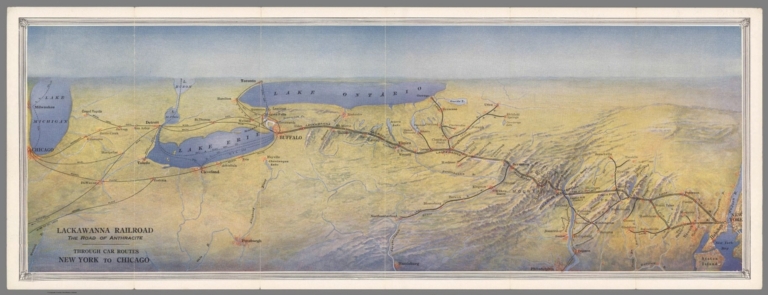
Author
Lackawanna Railroad
Full Title
Lackawanna Railroad. The Road of Anthracite. Through Car Routes New York to Chicago.
List No
10610.003
Author
Colton, G.W. & C.B.
Full Title
(Covers to) Colton's Railroad & Township Map of the State of Ohio. Published By G.W. & C.B. Colton, No. 172 William St. New York. 1867. Entered ... 1851 by J.H. Colton ... New York.
List No
0157.001
Note
As with all issues of this map, the primary difference between editions is the rapid railroad growth in the state. Full color by township. Map is folded into dark brown cloth covers 14.5x9 with "Colton's Township Map Of The State Of Ohio G.W. & C.B. Colton & Co." in gilt. Prime meridians are Greenwich and Washington D.C.
Author
Colton, G.W. & C.B.
Full Title
Colton's Railroad & Township Map of the State of Ohio. Published By G.W. & C.B. Colton, No. 172 William St. New York. 1867. Entered ... 1851 by J.H. Colton ... New York.
List No
0157.002
Note
As with all issues of this map, the primary difference between editions is the rapid railroad growth in the state. Full color by township. Map is folded into dark brown cloth covers 14.5x9 with "Colton's Township Map Of The State Of Ohio G.W. & C.B. Colton & Co." in gilt. Prime meridians are Greenwich and Washington D.C.
Author
Leahy, J.F.
Full Title
(Index to) Leahy's Hotel Guide and Railway Distance Maps. Ohio.
List No
0425.094
Note
Alphabetical index list of the Hotels of the town with the number of rooms of each, their rates per day and the population of the town. Includes population of the state, and Explanation of abbreviation of the railroad of the state.
Author
Leahy, J.F.
Full Title
Leahy's Hotel Guide and Railway Distance Map of the State of Ohio. Published by American Hotel Register Company. Leahy Build., 228-234 W. Ontario St., Chicago, Ill. Copyrighted by J.F. Leahy, Jan., 1934.
List No
0425.095
Note
Map printed without color. Includes name of the railroad entering the town, and distance between towns.
Author
Leahy, J.F.
Full Title
(Index to) Leahy's Hotel Guide and Railway Distance Maps. Ohio.
List No
0425.096
Note
Alphabetical index list of the Hotels of the town with the number of rooms of each, their rates per day and the population of the town. Includes population of the state, and Explanation of abbreviation of the railroad of the state.
Author
Leahy, J.F.
Full Title
Leahy's Hotel Guide and Railway Distance Map of the State of Ohio. Published by American Hotel Register Company. Leahy Build., 228-234 W. Ontario St., Chicago, Ill. Copyrighted by J.F. Leahy, Jan., 1934.
List No
0425.097
Note
Map printed without color. Includes name of the railroad entering the town, and distance between towns.
Author
Rand McNally and Company
Full Title
(Covers to) Ohio. Rand McNally & Co., Map Publishers and Engravers, Chicago, 1911. Rand, McNally & Co.'s New Business Atlas Map of Ohio. Copyright, 1911, ... 1902 ... (inset) Map Of Hamilton Co., Ohio. (with 110 page index) The Rand-McNally Indexed County And Railroad Pocket Map And Shippers' Guide Of Ohio ... Chicago And New York: Rand, McNally & Co. ... (on verso) Copyright, 1911, Rand, McNally & Co., Chicago.
List No
0789.001
Note
Full printed color by county. Map is folded into tan card board covers 17x10.5 with same title as index, but publisher information is given as "Rand McNally & Company, Chicago, New York, Los Angeles." Includes index to Ohio Chief Cities and the list of Ohio Railroads. The numbers in the list correspond to the numbers on the map.
Author
Rand McNally and Company
Full Title
(Title Page to) Ohio. Rand McNally & Co., Map Publishers and Engravers, Chicago, 1911. Rand, McNally & Co.'s New Business Atlas Map of Ohio. Copyright, 1911, ... 1902 ... (inset) Map Of Hamilton Co., Ohio. (with 110 page index) The Rand-McNally Indexed County And Railroad Pocket Map And Shippers' Guide Of Ohio ... Chicago And New York: Rand, McNally & Co. ... (on verso) Copyright, 1911, Rand, McNally & Co., Chicago.
List No
0789.002
Note
Full printed color by county. Map is folded into tan card board covers 17x10.5 with same title as index, but publisher information is given as "Rand McNally & Company, Chicago, New York, Los Angeles." Includes index to Ohio Chief Cities and the list of Ohio Railroads. The numbers in the list correspond to the numbers on the map.
Author
Rand McNally and Company
Full Title
Ohio. Rand McNally & Co., Map Publishers and Engravers, Chicago, 1911. Rand, McNally & Co.'s New Business Atlas Map of Ohio. Copyright, 1911, ... 1902 ... (inset) Map Of Hamilton Co., Ohio. (with 110 page index) The Rand-McNally Indexed County And Railroad Pocket Map And Shippers' Guide Of Ohio ... Chicago And New York: Rand, McNally & Co. ... (on verso) Copyright, 1911, Rand, McNally & Co., Chicago.
List No
0789.003
Note
Full printed color by county. Map is folded into tan card board covers 17x10.5 with same title as index, but publisher information is given as "Rand McNally & Company, Chicago, New York, Los Angeles." Includes index to Ohio Chief Cities and the list of Ohio Railroads. The numbers in the list correspond to the numbers on the map.
Author
Tanner, Henry S.
Full Title
Profile of the Erie Canal N.Y. ; Profile of the Ohio Canal ; Profile of the Chesapeake & Ohio Canal. (with inset profile) Baltimore & Ohio railroad. (to accompany) A Description of the Canals and Railroads of the United States.
List No
0979.005
Note
Three profiles on one page.
Author
United States. Post Office Department
Full Title
Post Route Map of Ohio and Indiana with Adjacent Parts of Pennsylvania, Michigan, Illinois, Kentucky and West Virginia.
List No
10437.002
Note
Updated to 1879 from 1870. 12 panels.
Author
[Cram, George F., Bennett, J.Q.A., Beers, J.H.]
Full Title
Ohio.
List No
12048.009
Author
Cram, George Franklin, 1841-1928
Full Title
Ohio : North half. 1899, by Geo. F. Cram.
List No
14372.063
Note
Map of Ohio (northern half). Shows political boundaries, counties, towns, railroads, steamship lines, topography, bodies of water, drainage, coastlines and islands. Relief shown with hachures. Includes key with explanation, latitudinal and longitudinal lines, as well as a bar scale given in miles. With alphanumeric grid corresponding to "Index of Ohio" on pages 111-113, 116-119, 122-125 and 128. Colored lithograph. Map is 40 x 54 cm, on double sheet 45 x 67 cm. "Index of maps" and "Index of cities" in margins, providing navigation for atlas as a whole. Southern half of map follows on pages 120-121.
Author
Cram, George Franklin, 1841-1928
Full Title
Ohio : [South half]. 1899, by Geo. F. Cram.
List No
14372.066
Note
Map of Ohio (southern half). Shows political boundaries, counties, towns, railroads, steamship lines, topography, bodies of water, drainage, coastlines and islands. Relief shown with hachures. Includes key with explanation, latitudinal and longitudinal lines, as well as a bar scale given in miles. Inset map: Map of Hamilton County, Ohio. With alphanumeric grid corresponding to "Index of Ohio" on pages 111-113, 116-119, 122-125 and 128. Colored lithograph. Map is 40 x 55 cm, on double sheet 45 x 67 cm. "Index of maps" and "Index of cities" in margins, providing navigation for atlas as a whole. Southern half of map precedes on pages 114-115.
Author
Cram, George Franklin, 1841-1928
Full Title
Ohio. 1899, by Geo. F. Cram.
List No
14372.070
Note
Map of Ohio. Shows political boundaries, counties, towns, railroads, steamship lines, topography, bodies of water, drainage, coastlines and islands. Relief shown with hachures. Includes key with explanation, latitudinal and longitudinal lines, as well as a bar scale given in miles. With alphanumeric grid corresponding to "Index of Ohio" on pages 111-113, 116-119, 122-125 and 128. Colored lithograph. Map is 42 x 55 cm, on double sheet 45 x 67 cm. "Index of maps" and "Index of cities" in margins, providing navigation for atlas as a whole.
Author
Howland, H.G.
Full Title
New Rail Road Map of Ohio. Drawn by H.G. Howland. Compiled & Published by R. Sutton, Ashland, O. 1880.
List No
2709.035
Note
Foldout.
Author
Gray, Frank Arnold
Full Title
New rail road map of the State of Ohio, compiled and drawn by Frank Arnold Gray, 1872. (Published by Stedman, Brown & Lyon, Cincinnati. 1872. Entered ... 1872, by H.F. Walling, and O.W. Gray, and H.H. Lloyd & Co. ... Washington)
List No
2710.006
Note
Hand col. lithographed map. Counties in full color.
Author
Cram, George Franklin
Full Title
Ohio. (inset) Map of Hamilton County.
List No
2809.022
Note
This map trimmed such that some information is lost on upper and right margins. Locations of banking towns shown by red circles. Railroads are indicated by numbers and colors and patterns, and each railroad has the same number and color and pattern in every state through which it passes. All railroads on each map are in a list keyed to the map. Border of map has a table of contents for the atlas. Relief shown by hachures. Prime meridians Washington D.C. and Greenwich.
Author
[Page, H.R. & Co., Barker, J.T.]
Full Title
J.T. Barker's Rail Road and Township Map of Ohio, Compiled & Engraved by H.R. Page & Co., Chicago, 1885.
List No
2871.017
Note
Prime meridians Washington D.C. and Greenwich.
Author
Colton, J.H.
Full Title
(Covers to) Colton's Railroad & Township Map of the State of Ohio. Published By J.H. Colton, No. 172 William St. New York. 1864. Entered ... 1851 by J.H. Colton ... New York.
List No
2960.001
Note
Compared to the 1860 edition, more railroads are added, plus a small population table in the lower left. The inside front cover ad is for G. Woolworth Colton alone, without the more usual C.B. Colton. This indicates that G.W. took over the firm alone for a short period and then brought in his brother. Full color by township. Map is folded into stamped brown cloth covers 14.5x9 with "Colton's Township Map Of The State Of Ohio J.H. Colton." in gilt. Prime meridians are Greenwich and Washington D.C.
Author
Colton, J.H.
Full Title
Colton's Railroad & Township Map of the State of Ohio. Published By J.H. Colton, No. 172 William St. New York. 1864. Entered ... 1851 by J.H. Colton ... New York.
List No
2960.002
Note
Compared to the 1860 edition, more railroads are added, plus a small population table in the lower left. The inside front cover ad is for G. Woolworth Colton alone, without the more usual C.B. Colton. This indicates that G.W. took over the firm alone for a short period and then brought in his brother. Full color by township. Map is folded into stamped brown cloth covers 14.5x9 with "Colton's Township Map Of The State Of Ohio J.H. Colton." in gilt. Prime meridians are Greenwich and Washington D.C.
Author
Norton, J.A.
Full Title
(Covers to) Railroad Map Of Ohio. Published By The State. 1890. Prepared By J.A. Norton, Commissioner of Railroads & Telegraphs. Columbus, Ohio. H.B. Stranahan & Co. Map Engravers & Publishers, Cleveland, Ohio. Copyright 1890 by H.B. Stranahan.
List No
3113.001
Note
1st edition 1887, last 1892. "Senatorial Map" stamped next to Title. The Senatorial Districts are outlined in red, with the District number stamped in blue ink. Covers are gray cloth 18.5x10 stamped with "Ohio Railway Map" in gilt.
Author
Norton, J.A.
Full Title
Railroad Map Of Ohio. Published By The State. 1890. Prepared By J.A. Norton, Commissioner of Railroads & Telegraphs. Columbus, Ohio. H.B. Stranahan & Co. Map Engravers & Publishers, Cleveland, Ohio. Copyright 1890 by H.B. Stranahan.
List No
3113.002
Note
1st edition 1887, last 1892. "Senatorial Map" stamped next to Title. The Senatorial Districts are outlined in red, with the District number stamped in blue ink. Covers are gray cloth 18.5x10 stamped with "Ohio Railway Map" in gilt.
Author
Thayer, Horace & Co.
Full Title
(Covers to) Railroad & Township Map Of Ohio. Published By Horace Thayer & Co. 50 Ann St. New York. 1853. Entered ... 1851 by Ensign, Thayer & Co. ... New York. W.S. Barnard Sc. J. Wells Del.
List No
3189.001
Note
Beautiful cartouche engraved by W.S. Barnard. 2nd ed., 1st ed. 1851. Very showy map with a picture of a steam engine smoking down the tracks through the title. Ensign and Thayer copyrighted the first edition in 1851. This is one of the clearest maps of Ohio done in the 19th century. Catalogue for Thayer's maps. Outline color by county, folded into ornately stamped red leather covers 14x9 with "Horace Thayer & Cos. Map Of Ohio" in gilt. Prime meridians are Greenwich and Washington D.C.
Author
Thayer, Horace & Co.
Full Title
Railroad & Township Map Of Ohio. Published By Horace Thayer & Co. 50 Ann St. New York. 1853. Entered ... 1851 by Ensign, Thayer & Co. ... New York. W.S. Barnard Sc. J. Wells Del.
List No
3189.002
Note
Beautiful cartouche engraved by W.S. Barnard. 2nd ed., 1st ed. 1851. Very showy map with a picture of a steam engine smoking down the tracks through the title. Ensign and Thayer copyrighted the first edition in 1851. This is one of the clearest maps of Ohio done in the 19th century. Catalogue for Thayer's maps. Outline color by county, folded into ornately stamped red leather covers 14x9 with "Horace Thayer & Cos. Map Of Ohio" in gilt. Prime meridians are Greenwich and Washington D.C.
Author
Titus, Clarence O.
Full Title
Titus' railroad & township map of the state of Ohio. (with view) State Capitol at Columbus. Published by C.O. Titus, 320 Chestnut St., Philadelphia, Pa. (1869)
List No
3748.038
Note
Hand col. lithographed map. Shows counties and townships, railroads, canals, post roads, etc. Prime meridians: Greenwich and Washington. "Colton's Ohio map is used without attribution and under Titus' imprint"--David Rumsey Collection catalog.
Author
Colton, J.H.
Full Title
(Covers to) Colton's Railroad & Township Map of the State of Ohio. Published By Johnson & Browning, No. 172 William St. New York. 1859. Entered ... 1851 by J.H. Colton ... New York. Drawn by George W. Colton. Engraved by J.M. Atwood, New York.
List No
4510.001
Note
Many new railroads compared to the 1853 edition. An example of Johnson & Browning publishing the Colton maps in 1859 and 1860. See also our #182, 4506, and 4096 for other Johnson & Browning/Colton pocket maps. Full color. Folded into stamped brown cloth covers 14.5x9 with "Colton's Township Map Of The State Of Ohio Johnson & Browning." in gilt. Prime meridians are Greenwich and Washington D.C.
Author
Colton, J.H.
Full Title
Colton's Railroad & Township Map of the State of Ohio. Published By Johnson & Browning, No. 172 William St. New York. 1859. Entered ... 1851 by J.H. Colton ... New York. Drawn by George W. Colton. Engraved by J.M. Atwood, New York.
List No
4510.002
Note
Many new railroads compared to the 1853 edition. An example of Johnson & Browning publishing the Colton maps in 1859 and 1860. See also our #182, 4506, and 4096 for other Johnson & Browning/Colton pocket maps. Full color. Folded into stamped brown cloth covers 14.5x9 with "Colton's Township Map Of The State Of Ohio Johnson & Browning." in gilt. Prime meridians are Greenwich and Washington D.C.
Author
Cram, George Franklin
Full Title
Cram's Rail Road & Township Map of Ohio.
List No
4533.013
Author
Colton, J.H.
Full Title
(Covers to) Colton's Railroad & Township Map of the State of Ohio. Published By J.H. Colton, No. 172 William St. New York. 1860. Entered ... 1851 by J.H. Colton ... New York.
List No
4553.001
Note
The 1859 edition was published by Johnson and Browning; this edition returns to J.H. Colton as the publisher, showing that Colton took back his publishing of pocket maps from Johnson (who only seems to have had the business for 1859 and part of 1860) in late 1860. Folded into stamped red cloth covers 14.5x9 with "Colton's Township Map Of The State Of Ohio J.H. Colton." in gilt. Full color by township. Prime meridians are Greenwich and Washington D.C.
Author
Colton, J.H.
Full Title
Colton's Railroad & Township Map of the State of Ohio. Published By J.H. Colton, No. 172 William St. New York. 1860. Entered ... 1851 by J.H. Colton ... New York.
List No
4553.002
Note
The 1859 edition was published by Johnson and Browning; this edition returns to J.H. Colton as the publisher, showing that Colton took back his publishing of pocket maps from Johnson (who only seems to have had the business for 1859 and part of 1860) in late 1860. Folded into stamped red cloth covers 14.5x9 with "Colton's Township Map Of The State Of Ohio J.H. Colton." in gilt. Full color by township. Prime meridians are Greenwich and Washington D.C.
Author
[Walling, Henry Francis, 1825-1888, Lloyd, H.H.]
Full Title
Railroad map of Ohio, Indiana and Illinois. Published for Henry S. Stebbins By H.H. Lloyd & Co. New York. (to accompany) Atlas Of The State Of Ohio. 1868.
List No
4726.036
Note
Hand colored map. Shows counties, roads, railroads, canals, cities and towns for Ohio, Indiana and Illinois. Relief shown by hachures.
Author
Cram, George Franklin
Full Title
Railroad and County Map of Oiho [sic] (Ohio). Geo. F. Cram. Engraver and Publisher, Chicago.
List No
4727.019
Note
Prime meridians Washington D.C. and Greenwich. Relief shown by hachures. With printed color.
Author
Rand McNally and Company
Full Title
Commercial Atlas of America. Rand McNally Standard Map of Ohio. (Northern Section)
List No
5028.071
Note
Shows railroads and distances. Includes tables of principal cities and railroads, keyed to map.
Author
Rand McNally and Company
Full Title
Commercial Atlas of America. Rand McNally Standard Map of Ohio. (Southern Section)
List No
5028.072
Note
Shows railroads and distances. Includes tables of principal cities and railroads, keyed to map.
Author
Rand McNally and Company
Full Title
Commercial Atlas of America. Rand McNally Black and White Mileage Map, Ohio.
List No
5028.073
Note
Shows railroads and distances.
Author
Caldwell, Joseph A.
Full Title
Map of the Pittsburgh, Cincinnati and St. Louis R.R. Pan Handle Route and Principal Connections. Rand Mcnally & Co., Engraver, Chicago. Printed under Patent of January 12, 1875. ( (to accompany) Caldwell's Illustrated, Historical, Centennial Atlas Of Beaver County, Pennsylvania. From actual Surveys by & under the directions of J.A. Caldwell. Assisted by C.T. Arms, Sr. C.E. J.A. Underwood, C.E. J.A. Howden. P.L. Mason. W.J. Kerstetter, C.E. W.F. Arms, C.E. J.J. Power, C.E. Published By J.A. Caldwell, Condit, Ohio. 1876. Engraved, Lithographed & Printed By Otto Krebs, Pittsburgh, Pa.
List No
5043.067
Note
Full color map of the Northeastern United States, showing cities and towns, and the railroad network with named lines. Emphasis on the main lines. Relief shown by hachures.
Author
Caldwell, Joseph A.
Full Title
(Advertisement to) The Great Pan Handle Route. D.W. Caldwell, General Manage, Columbus, Ohio. W.L. O"Brian, General Passenger and Ticket Agent, Columbus, Ohio. ( (to accompany) Caldwell's Illustrated, Historical, Centennial Atlas Of Beaver County, Pennsylvania. From actual Surveys by & under the directions of J.A. Caldwell. Assisted by C.T. Arms, Sr. C.E. J.A. Underwood, C.E. J.A. Howden. P.L. Mason. W.J. Kerstetter, C.E. W.F. Arms, C.E. J.J. Power, C.E. Published By J.A. Caldwell, Condit, Ohio. 1876. Engraved, Lithographed & Printed By Otto Krebs, Pittsburgh, Pa.
List No
5043.068
Note
full page advertisement for "The great Pan Handle Route." Provides the featured routes, connecting North, South, East and West.
Author
Cram, George Franklin
Full Title
Cram's Rail Road & Township Map of Ohio. Published by Geo. F. Cram. Proprietor of the Western Map Depot. 66, Lake St. Chicago Ills. 1875.
List No
5370.010
Note
Map in full color by county. The railroad lines are clearly marked.
Author
G.W. & C.B. Colton & Co.
Full Title
Maps showing the Indiana & Illinois Central Railway. And Its Connections. Prepared By G.W. & C.B. Colton & Co. 172 William Street New York. Entered ... 1872 by G.W. & C.B. Colton & Co. ... Washington. (with) Untitled inset map of railway connections from the Eastern Seaboard to Colorado and Wyoming.
List No
5439.000
Note
Outline hand coloring with rail lines highlighted in blue and red. Fingers point the way on the large map to New York, Boston, Philadelphia, Baltimore and Norfolk.
Author
Rand McNally and Company
Full Title
(Covers to) Rand, McNally & Co.'s New Shippers' Railroad Map of the United States. Scale: 8 miles to one inch. Showing all railroads, each in a separate color, and all railroad stations in large, plain type. (Below the neatline) Rand, McNally & Co.'s New Shippers' Railroad Map of the United States, Copyright, 1888 by Rand, McNally & Co. Copyright, 1891 by Rand, McNally & Co.
List No
5802I
Note
This is the Indiana/Ohio/Pennsylvania/Michigan section of the larger map.
Author
Rand McNally and Company
Full Title
Rand, McNally & Co.'s New Shippers' Railroad Map of the United States. Scale: 8 miles to one inch. Showing all railroads, each in a separate color, and all railroad stations in large, plain type. (Below the neatline) Rand, McNally & Co.'s New Shippers' Railroad Map of the United States, Copyright, 1888 by Rand, McNally & Co. Copyright, 1891 by Rand, McNally & Co.
List No
5802.009
Note
This is the Indiana/Ohio/Pennsylvania/Michigan section of the larger map.
Author
Horace Thayer & Co.
Full Title
Railroad and township map of Ohio. Published by Horace Thayer & Co., 50 Ann Street, New York. Entered ... 1852 by Horace Thayer & co., ... New York.
List No
8530.000
Note
Color map, outline color by county, framed with elaborate boarders. Backed on linen, Map attached to rods for hanging. Shows railroads, counties, township boundaries, canals, roads, cities, towns, and notable physical features. Includes population tables, note on "Description of Ohio", Seal of Ohio, and illustration. Prime meridians are Greenwich and Washington.
1-46 of 46
|
![Composite Map: Ohio : North half. -- Ohio : [South half].](https://www.davidrumsey.com/rumsey/Size2/RUMSEY~8~1/205/14372067.jpg)


![Ohio : [South half].](https://www.davidrumsey.com/rumsey/Size2/RUMSEY~8~1/205/14372066.jpg)


