|
REFINE
Browse All : Railroad of New Mexico
1-23 of 23
Author
New Mexico State Corporation Commission
Full Title
Railroad Map Of The State Of New Mexico Prepared Under the Direction of State Corporation Commission 1913 ... Commissioners, Hugh H. Williams, Chairman, M.S. Groves, Commissioner, O.L. Owen, Commissioner. Santa Fe, N.M. (seal) State Corporation Commission Of New Mexico.
List No
4236.002
Author
Atlantic & Pacific Railroad
Full Title
Map of the First Operating Division of the Western Division, Atlantic & Pacific R.R., From Albuquerque to Coolidge. Drawing No. J2-902. Lewis Kingman, Chief Engineer.
List No
6929.001
Note
A set of six hand-drawn maps on semi-transparent waxed linen with some color. Some areas are colored on the verso to highlight the areas in a muted style. We think that some type of backlighting was planned to be used to create a photolithographic plate from which printing would be done. No evidence was found that it was ever printed. These sheets were deaccessioned from the Santa Fe Railroad collection in the 1980s. Lewis Kingman did the route survey from Albuquerque to Needles. Relief shown by hachures. This sheet has colored lines on the verso to add color to the various areas depicted on the recto.
Author
Atlantic & Pacific Railroad
Full Title
Map of the 2nd Operating Division of the Western Division, Atlantic & Pacific R.R., From Coolidge to Winslow. Drawing No. J-2-902.
List No
6929.002
Note
Lavishly illustrated title block. No drawing on verso. A set of six hand-drawn maps on semi-transparent waxed linen with some color. Some areas are colored on the verso to highlight the areas in a muted style. We think that some type of backlighting was planned to be used to create a photolithographic plate from which printing would be done. No evidence was found that it was ever printed. These sheets were deaccessioned from the Santa Fe Railroad collection in the 1980s. Lewis Kingman did the route survey from Albuquerque to Needles. Relief shown by hachures.
Author
Atlantic & Pacific Railroad
Full Title
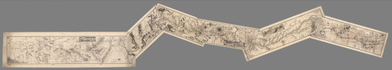
(Composite of) Maps of the First through Sixth Operating Divisions of the Western Division, Atlantic & Pacific Railroad, Albuquerque, New Mexico, to Mojave (Mohave), California.
List No
6929.007
Note
Composite of all six maps joined together end to end. This is a set of six hand-drawn maps on semi-transparent waxed linen with some color. Some areas are colored on the verso to highlight the areas in a muted style. We think that some type of backlighting was planned to be used to create a photolithographic plate from which printing would be done. No evidence was found that it was ever printed. These sheets were deaccessioned from the Santa Fe Railroad collection in the 1980s. Lewis Kingman did the route survey from Albuquerque to Needles. Relief shown by hachures.
Author
Leahy, J.F.
Full Title
(Index to) Leahy's Hotel Guide and Railway Distance Maps. New Jersey (Continued). New Mexico.
List No
0425.082
Note
Continuation index list of the Hotels of the town with the number of rooms of each, their rates per day and the population of the town in New Jersey and Index list of New Mexico. Includes population of the states, Explanation of abbreviation of the railroad of the state, and advertisement.
Author
Leahy, J.F.
Full Title
Leahy's Hotel Guide and Railway Distance Map of the State of New Mexico. Published by American Hotel Register Company. Leahy Build., 228-234 W. Ontario St., Chicago, Ill. Copyrighted by J.F. Leahy, Jan., 1934.
List No
0425.083
Note
Map printed without color. Includes name of the railroad entering the town, and distance between towns.
Author
Gunnison, J.W.
Full Title
From the Santa Fe Crossing to the Coo-che-to-pa Pass; from Explorations and Surveys made under the direction of the Hon. Jefferson Davis Secretary of War by Capt. J.W. Gunnison. Topl. Engrs. assisted by Capt. E.G. Beckwith 3d Artillery. R.H. Kern Topographer in the field. Map made under the supervision of Capt. E.G. Beckwith 3d Artillery by F.W. Egloffstein, Topographer for the Route. 1855. Explorations and surveys for a railroad route from the Mississippi River to the Pacific Ocean. War Department. Route near the 38th & 39th Parallels. Map No. 3. Engr. by Selmar Siebert.
List No
0693.035
Note
Uncolored map covers the area from Elk Island in the Arkansas River (Kansas) to Sahwatch Creek (Colorado). Pueblo, Colorado and Pike's Peak are shown. Settlements can be seen running south from the Sangre de Cristo Mountains to Taos (New Mexico).
Author
[Ives, J.C., Whipple, A.W.]
Full Title
From Fort Smith to the Rio Grande from explorations and surveys made under the direction of the Hon. Jefferson Davis, Secretary of War by Lieut. A.W. Whipple, Topogl. Engrs. and Lieut. J.C. Ives, Topogl. Engrs. A.H. Campbell, Civil Eng. and Surveyor, Asst. Surveyors: Wm. White Jr., N.H. Hutton, and J.P. Sherburne. 1853-4. Explorations and Surveys for a Rail Road Route from the Missisippi (sic) River to the Pacific Ocean, War Department, Route Near the 35th Parallel, Map No. 1. Engr. by Selmar Siebert.
List No
0693.037
Note
Map begins in the east at Ft. Smith (Arkansas) and continues along the Red River through Texas ending at the Rio Grande in present-day New Mexico. With inset map, "Sketch of the Rio Pecos at Anton Chico."
Author
[Ives, J.C., Whipple, A.W.]
Full Title
From the Rio Grande to the Pacific Ocean from explorations and surveys made under the direction of the Hon. Jefferson Davis, Secretary of War by Lieut. A.W. Whipple, Topogl. Engrs. and Lieut. J.C. Ives, Topogl. Engrs. A.H. Campbell, Civil Eng. and Surveyor, Asst. Surveyors: Wm. White Jr., N.H. Hutton, and J.P. Sherburne. 1853-4. Explorations and Surveys for a Rail Road Route from the Mississippi River to the Pacific Ocean, War Department, Route Near the 35th Parallel, Map No. 2. Engr. by Selmar Siebert. Drawn by John D. Hoffmann.
List No
0693.038
Note
The uncolored map stretches from Albuquerque in the east across the southwest to Los Angeles. With two inset maps: "Sketch of Campbell's Pass from Agua Azul to Salt Spring" and "Sketch of Aztec Pass."
Author
[United States. General Land Office, King, Harry]
Full Title
Department of Interior, General Land Office, Hon S. W. Lamoreeu Commissioner. Territory of New Mexico. 1896. Compiled from the official records of the General Land Office and other sources, under supervision of Harry King, C.E. Compiled and drawn by Robert H. Morton. A.B. Graham photo. lith. Washington, D.C.
List No
13041.000
Note
Color map, dissected and mounted on linen, folded to 20x14. Shows township grid, railroads, Indian reservations, military reservations, forests, private land grants, and mining activity. Includes legend. Prime meridians are Washington and Greenwich. Relief shown by hachures.
Author
Cram, George Franklin, 1841-1928
Full Title
New Mexico. 1899, by Geo. F. Cram.
List No
14372.197
Note
Map of New Mexico. Shows political boundaries, counties, towns, railroads, topography, bodies of water, drainage, coastlines and islands. Relief shown with hachures. Includes key with explanation, latitudinal and longitudinal lines, as well as a bar scale given in miles. With alphanumeric grid corresponding to "Index of New Mexico Territory" on pages 366-367. Colored lithograph. Map is 56 x 40 cm, on double sheet 67 x 45 cm. "Index of maps" and "Index of cities" in margins, providing navigation for atlas as a whole.
Author
Cram, George Franklin
Full Title
New Mexico.
List No
2809.054
Note
Locations of banking towns shown by red circles. Railroads are indicated by numbers and colors and patterns, and each railroad has the same number and color and pattern in every state through which it passes. All railroads on each map are in a list keyed to the map. Border of map has a table of contents for the atlas. Relief shown by hachures. Prime meridians Washington D.C. and Greenwich.
Author
Rand McNally and Company
Full Title
(Covers to) The Rand McNally New Commercial Atlas Map Of New Mexico ... Copyright by Rand McNally & Co. (on verso) New Mexico Automobile Road Map.(with 27 page index) Rand McNally Indexed Pocket Map Tourists' And Shippers' Guide Of New Mexico ... Rand McNally & Company, Chicago 536 South Clark St., New York 42 East 22nd St. (on verso) Copyright, 1920, by Rand McNally & Co., Chicago.
List No
3183.001
Note
The map is from the Commercial Atlas of the U.S. On the verso of the main map is "New Mexico Automobile Road Map" with Auto Roads shown in red on a base map that is the same as the main map. The main map is in full printed color. Covers are brown card board 17x11 printed with "New Mexico. Rand McNally Indexed Pocket Map Tourists' And Shippers' Guide ... Price 35 Cents. Rand McNally & Company ..." Includes index to New Mexico Principal Cities and the list of New Mexico Railroads. The numbers in the list correspond to the numbers on the map. Prime meridian is Greenwich. Relief shown by hachures.
Author
Rand McNally and Company
Full Title
(Title Page to) The Rand McNally New Commercial Atlas Map Of New Mexico ... Copyright by Rand McNally & Co. (on verso) New Mexico Automobile Road Map.(with 27 page index) Rand McNally Indexed Pocket Map Tourists' And Shippers' Guide Of New Mexico ... Rand McNally & Company, Chicago 536 South Clark St., New York 42 East 22nd St. (on verso) Copyright, 1920, by Rand McNally & Co., Chicago.
List No
3183.002
Note
The map is from the Commercial Atlas of the U.S. On the verso of the main map is "New Mexico Automobile Road Map" with Auto Roads shown in red on a base map that is the same as the main map. The main map is in full printed color. Covers are brown card board 17x11 printed with "New Mexico. Rand McNally Indexed Pocket Map Tourists' And Shippers' Guide ... Price 35 Cents. Rand McNally & Company ..." Includes index to New Mexico Principal Cities and the list of New Mexico Railroads. The numbers in the list correspond to the numbers on the map. Prime meridian is Greenwich. Relief shown by hachures.
Author
Rand McNally and Company
Full Title
The Rand McNally New Commercial Atlas Map Of New Mexico ... Copyright by Rand McNally & Co. (on verso) New Mexico Automobile Road Map.(with 27 page index) Rand McNally Indexed Pocket Map Tourists' And Shippers' Guide Of New Mexico ... Rand McNally & Company, Chicago 536 South Clark St., New York 42 East 22nd St. (on verso) Copyright, 1920, by Rand McNally & Co., Chicago.
List No
3183.003
Note
The map is from the Commercial Atlas of the U.S. On the verso of the main map is "New Mexico Automobile Road Map" with Auto Roads shown in red on a base map that is the same as the main map. The main map is in full printed color. Covers are brown card board 17x11 printed with "New Mexico. Rand McNally Indexed Pocket Map Tourists' And Shippers' Guide ... Price 35 Cents. Rand McNally & Company ..." Includes index to New Mexico Principal Cities and the list of New Mexico Railroads. The numbers in the list correspond to the numbers on the map. Prime meridian is Greenwich. Relief shown by hachures.
Author
Rand McNally and Company
Full Title
The Rand McNally New Commercial Atlas Map Of New Mexico ... Copyright by Rand McNally & Co. (on verso) New Mexico Automobile Road Map.(with 27 page index) Rand McNally Indexed Pocket Map Tourists' And Shippers' Guide Of New Mexico ... Rand McNally & Company, Chicago 536 South Clark St., New York 42 East 22nd St. (on verso) Copyright, 1920, by Rand McNally & Co., Chicago.
List No
3183.004
Note
The map is from the Commercial Atlas of the U.S. On the verso of the main map is "New Mexico Automobile Road Map" with Auto Roads shown in red on a base map that is the same as the main map. The main map is in full printed color. Covers are brown card board 17x11 printed with "New Mexico. Rand McNally Indexed Pocket Map Tourists' And Shippers' Guide ... Price 35 Cents. Rand McNally & Company ..." Includes index to New Mexico Principal Cities and the list of New Mexico Railroads. The numbers in the list correspond to the numbers on the map. Prime meridian is Greenwich. Relief shown by hachures.
Author
Cram, George Franklin
Full Title
Cram's Rail Road & Township Map of New Mexico.
List No
4533.032
Author
Cram, George Franklin
Full Title
New Rail Road and County Map of New Mexico.
List No
4558.055
Author
Cram, George Franklin
Full Title
Railroad and County Map of New Mexico. Geo. F. Cram. Engraver and Publisher, Chicago.
List No
4727.048
Note
Prime meridians Washington D.C. and Greenwich. Relief shown by hachures. With printed color.
Author
Rand McNally and Company
Full Title
Commercial Atlas of America. Rand McNally Standard Map of New Mexico.
List No
5028.126
Note
Shows railroads and distances. Includes tables of principal cities and railroads, keyed to map. Relief shown by hachures.
Author
Rand McNally and Company
Full Title
Commercial Atlas of America. Rand McNally Black and White Mileage Map, Arizona and New Mexico.
List No
5028.128
Note
Shows railroads and distances.
Author
Rand McNally and Company
Full Title
(Covers to) Rand, McNally & Co.'s New Shippers' Railroad Map of the United States. Scale: 8 miles to one inch. Showing all railroads, each in a separate color, and all railroad stations in large, plain type. This is the El Paso section only, of the above named map. (Below the neatline) Rand, McNally & Co.'s Shippers' Railway Map of the United States, Copyright, 1891 by Rand, McNally & Co.
List No
5802A
Note
This is the El Paso section of the larger map.
Author
Rand McNally and Company
Full Title
Rand, McNally & Co.'s New Shippers' Railroad Map of the United States. Scale: 8 miles to one inch. Showing all railroads, each in a separate color, and all railroad stations in large, plain type. This is the El Paso section only, of the above named map. (Below the neatline) Rand, McNally & Co.'s Shippers' Railway Map of the United States, Copyright, 1891 by Rand, McNally & Co.
List No
5802.001
Note
This is the El Paso section of the larger map.
1-23 of 23
|