|
REFINE
Browse All : Railroad of Morocco
1-3 of 3
Author
[Hauchecorne, G., Vandermaelen, Philippe, 1795-1869, Etablissement geographique de Bruxelles]
Full Title
Espagne meridle., Algerie et Maroc. (to accompany) Carte generale des chemins de fer de l' Europe dressee d' apres des documents officiels, par G. Hauchecorne, Agent General de Chemins de fer. 1863. Etablissement geographique de Bruxelles, fonde par Ph. Vander Maelen. (Cover title) Schweizerische Nordostbahn.
List No
11612.008
Note
First edition railroad map of Europe. 1 map in 9 double page sheets. Full color by country. One of several large-scale railway maps produced by G. Hauchecorne, Agent General de Chemins de Fer, for the great Brussels publisher Philippe Vandermaelen. Each map includes separate title, showing railway system of each country, roads, major cities, towns, stations and distances between the larger cities. Railway routes shown in solid and broken lines. All lines represent the route and distances. Relief shown by hachures. Atlas title is from the first plate. The first map (Great Britain) includes inset of map of London and fourth plate (France, Espagne) includes inset map of Paris. Bound in black paper cover boards with label "Schweizerische Nordostbahn" pasted on front cover.
Author
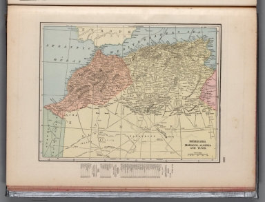
Cram, George Franklin, 1841-1928
Full Title
Northwest Africa, Morocco, Algeria and Tunis.
List No
14372.347
Note
Map of Northwest Africa, including Morocco, Algeria and Tunis (Tunisia). Shows political boundaries, cities, railroads, submarine telegraph lines, topography, deserts, bodies of water, drainage, coastlines, islands and water routes. Relief shown with hachures. Includes latitudinal and longitudinal lines, as well as a bar scale given in miles. Provides figures for square milage and population. Map indexed to indicate place names. Colored lithograph. Map is 24 x 32 cm, on sheet 33 x 45 cm.
Author
Cram, George Franklin
Full Title
Northwest Africa, Morocco, Algeria, and Tunis.
List No
2809.161
Note
Relief shown by hachures. Prime meridians Washington D.C. and Greenwich. Countries differentiated in full color.
1-3 of 3
|