|
REFINE
Browse All : Railroad of Cuba
1-13 of 13
Author
[Canet Alvarez, Gerardo A., 1911-, Raisz, Erwin, 1893-1968, Harvard University. Institute of Geographical Exploration, Cuba. Ministerio de Agricultura]
Full Title
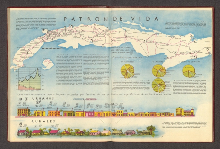
Patron de vida.
List No
14350.019
Note
Map showing the human geography of Cuba. Title translates to: Life patterns Features roads, railways, population and water consumption in the country. Includes a bar scale. With views comparing urban and rural communities. With charts depicting the economy, tracing changes in the twentieth century. Accompanied by descriptive text, which appears in Spanish, with English translations.
Instituto de Geografía (Academia de Cie... Principales ferrocarriles de uso publico... 1970 13566.081 Related Author
[Instituto de Geografía (Academia de Ciencias de Cuba), Akademiia nauk SSSR. Institut geografii.]
Full Title
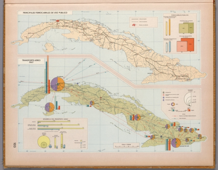
Principales ferrocarriles de uso publico. Transporte aereo, 1967. Atlas nacional de Cuba : en el decimo aniversario de la Revolucion. La Habana 1970.
List No
13566.081
Note
2 maps on 1 sheet. Shows railway system and air transportation system in Cuba. Includes graphs and diagrams.
Author
[Canet Alvarez, Gerardo A., 1911-, Raisz, Erwin, 1893-1968, Harvard University. Institute of Geographical Exploration, Cuba. Ministerio de Agricultura]
Full Title
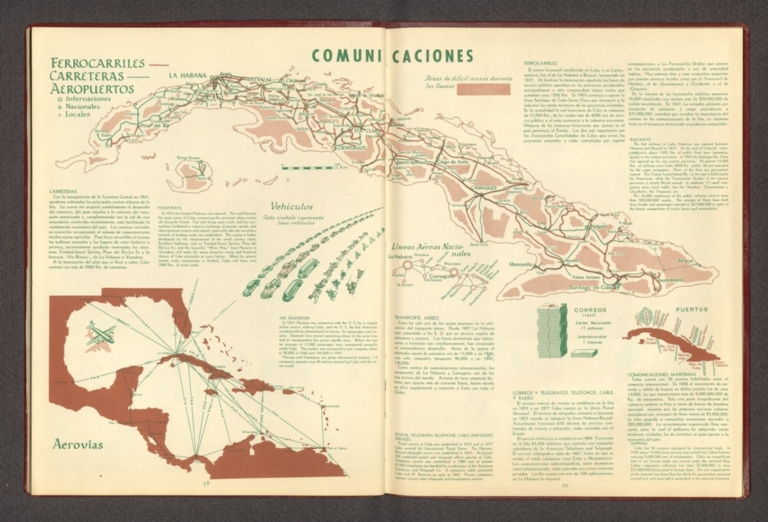
Comunicaciones.
List No
14350.033
Note
Map showing the geography of transportation and communication in Cuba. Title translates to: Communications. Features distribution of roads and railways in the country. Includes a bar scale. With three inset maps: Aerovías [= Airways] -- Líneas aéreas nacionales [= National airlines] -- Puertos [= Ports]. In addition, with charts and diagrams depicting vehicles and mail. Accompanied by descriptive text, which appears in Spanish, with English translations.
Author
Cram, George Franklin, 1841-1928
Full Title
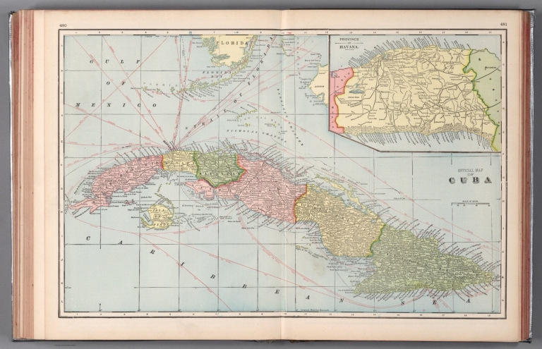
Official map of Cuba. 1899, by Geo. F. Cram.
List No
14372.270
Note
Map of Cuba. Shows political boundaries, provinces, towns, railroads, topography, bodies of water, drainage, marshes, coastlines and islands. Relief shown with hachures. Includes latitudinal and longitudinal lines, as well as water routes with distances and a bar scale given miles. Inset map: Province of Havana. With alphanumeric grid corresponding to "Index of Cuba" on pages 479 and 482. Colored lithograph. Map is 38 x 60 cm, on double sheet 45 x 67 cm. "Index of maps" and "Index of cities" in margins, providing navigation for atlas as a whole.
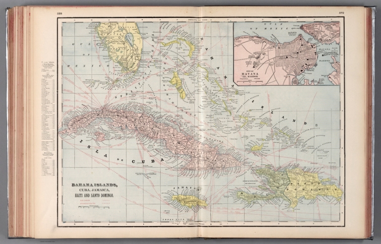
Author
Cram, George Franklin, 1841-1928
Full Title
Bahama Islands, Cuba, Jamaica, Haiti and Santo Domingo.
List No
14372.303
Note
Map of the Bahamas, Cuba, Jamaica, Haiti and Santo Domingo. Shows political boundaries, cities, railroads, topography, bodies of water, drainage, coastlines and islands. Relief shown with hachures. Includes latitudinal and longitudinal lines, as well as water routes with distances and a bar scale given in miles. Provides figures for square milage and population. Inset map: City of Havana and Harbor. Map indexed to indicate place names. Colored lithograph. Map is 39 x 56 cm, on double sheet 45 x 67 cm.
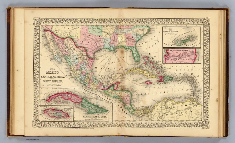
Mitchell, Samuel Augustus; Williams, W. ... Mexico, Central America, West Indies. 1870 2483.042 Related Author
[Mitchell, Samuel Augustus, Williams, W. (Wellington)]
Full Title
Map of Mexico, Central America, and the West Indies. (with) Map of the island of Cuba. (with) Map of the island of Jamaica. (with) Map of the Bermuda Islands. (with) Map of the Panama Railroad. Constructed & engraved by W. Williams, Philadelphia. Entered ... 1870 by S. Augustus Mitchell, Jr. ... Pennsylvania.
List No
2483.042
Note
Hand colored maps with 4 insets. Relief shown by hachures. Shows states, settlements, railroads, rivers, etc. Prime meridians: Greenwich and Washington.
Author
Cram, George Franklin
Full Title
Cuba. (inset) Province of Havana.
List No
2809.086
Note
Locations of banking towns shown by red circles. Railroads are indicated by numbers and colors and patterns, and each railroad has the same number and color and pattern in every state through which it passes. All railroads on each map are in a list keyed to the map. Border of map has a table of contents for the atlas. Relief shown by hachures. Prime meridians Washington D.C. and Greenwich.
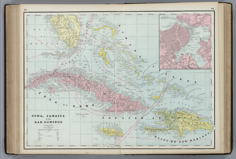
Author
Cram, George Franklin
Full Title
Cuba, Jamaica and San Domingo. (inset) City of Habana (Havana).
List No
4727.086
Note
Prime meridians Washington D.C. and Greenwich. Relief shown by hachures. With printed color. Steamship routes shown.
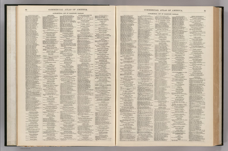
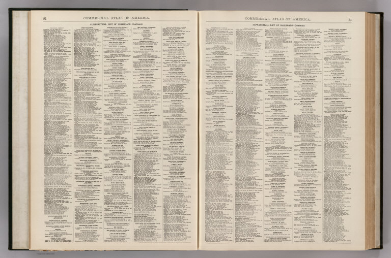
Author
Rand McNally and Company
Full Title
(Text Page) Alphabetical List of All Railroads.
List No
5028R
Note
Railroads include Canada, Mexico, Cuba, Puerto Rico, and Hawaii.
Author
Rand McNally and Company
Full Title
(Text Page) Alphabetical List of All Railroads.
List No
5028S
Note
Railroads include Canada, Mexico, Cuba, Puerto Rico, and Hawaii.
Author
Rand McNally and Company
Full Title
(Text Page) Alphabetical List of All Railroads.
List No
5028T
Note
Railroads include Canada, Mexico, Cuba, Puerto Rico, and Hawaii.
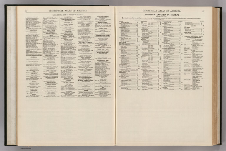
Author
Rand McNally and Company
Full Title
(Text Page) Alphabetical List of All Railroads. Railroads Grouped by Systems.
List No
5028U
Note
Railroads include Canada, Mexico, Cuba, Puerto Rico, and Hawaii.
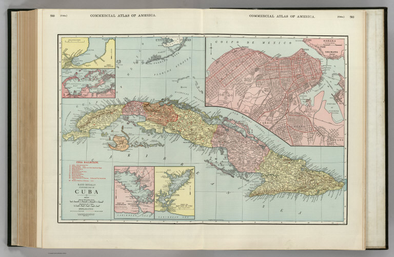
Author
Rand McNally and Company
Full Title
Commercial Atlas of America. Rand McNally Standard Map of Cuba. (with) Port Matanzas. (with) Cardenas and Santa Clara Bays. (with) Port of Cienfuegos. (with) Port of Santiago de Cuba. (with) Habana.
List No
5028.177
Note
Shows railroads and distances. Includes table of railroads keyed to map.
1-13 of 13
|