|
REFINE
Browse All : Railroad of Colorado
1-29 of 29
Author
Cram, George Franklin, 1841-1928
Full Title
Colorado. 1899, by Geo. F. Cram.
List No
14372.114
Note
Map of Colorado. Shows political boundaries, counties, towns, railroads, topography, bodies of water, drainage, coastlines and islands. Relief shown with hachures. Includes key with explanation, latitudinal and longitudinal lines, as well as a bar scale given in miles. With alphanumeric grid corresponding to "Index of Colorado" on pages 208-211 and 214-215. Colored lithograph. Map is 40 x 55 cm, on double sheet 45 x 67 cm. "Index of maps" and "Index of cities" in margins, providing navigation for atlas as a whole.
Author
Cram, George Franklin, 1841-1928
Full Title
Cram's railroad and township map of Colorado. Published by Geo. F. Cram. 262-264 Wabash Ave. Chicago, Ills. 1882.
List No
14250.028
Note
Map of Colorado, showing railroads, county boundaries, cities and towns, and drainage. Political boundary lines in color. With index numbers along the perimeter, and decorative border. Also, with hand-drawn annotations tracing routes of travel, both along railroads and across landscapes where no official transit appears. 40 x 52 cm, on sheet 45 x 58.
Author
Colorado Ry. Co.
Full Title
Topographical Map of Ralston Creek - Station 1283-2093 "H.T. Line T.R. Countryman Eng. 1886 Traced from Sheets Sept. 1914. P-3015-26_3
List No
10303.000
Note
Blueprint.
Author
[Hayden, Ferdinand Vandeveer, 1829-1887, Russell, Andrew Joseph, 1830-1902]
Full Title
Skull Rock - (granite) Sherman Station, Laramie Mountains. (to accompany) Sun pictures of Rocky Mountain scenery ... by F. V. Hayden, ... New York : Julius Bien, 1870.
List No
13389.007
Note
Black and white view of Skull Rock. Shows rock formation.
Author
Leahy, J.F.
Full Title
(Index Page to) Leahy's Hotel Guide and Railway Distance Maps. Colorado.
List No
0425.016
Note
Alphabetical index list of the Hotels of the town with the number of rooms of each, their rates per day and the population of the town. Includes population of the state.
Author
Leahy, J.F.
Full Title
Leahy's Hotel Guide and Railway Distance Map of the State of Colorado. Published by American Hotel Register Company. Leahy Build., 228-234 W. Ontario St., Chicago, Ill. Copyrighted by J.F. Leahy, Jan., 1934.
List No
0425.017
Note
Map printed without color. Includes name of the railroad entering the town, and distance between towns.
Author
Gunnison, J.W.
Full Title
From the Santa Fe Crossing to the Coo-che-to-pa Pass; from Explorations and Surveys made under the direction of the Hon. Jefferson Davis Secretary of War by Capt. J.W. Gunnison. Topl. Engrs. assisted by Capt. E.G. Beckwith 3d Artillery. R.H. Kern Topographer in the field. Map made under the supervision of Capt. E.G. Beckwith 3d Artillery by F.W. Egloffstein, Topographer for the Route. 1855. Explorations and surveys for a railroad route from the Mississippi River to the Pacific Ocean. War Department. Route near the 38th & 39th Parallels. Map No. 3. Engr. by Selmar Siebert.
List No
0693.035
Note
Uncolored map covers the area from Elk Island in the Arkansas River (Kansas) to Sahwatch Creek (Colorado). Pueblo, Colorado and Pike's Peak are shown. Settlements can be seen running south from the Sangre de Cristo Mountains to Taos (New Mexico).
Author
Gunnison, J.W.
Full Title
From the Coo-che-to-pa Pass to the Wahsatch Mountains; from Explorations and Surveys made under the direction of the Hon. Jefferson Davis Secretary of War by Capt. J.W. Gunnison. Topl. Engrs. assisted by Capt. E.G. Beckwith 3d Artillery. R.H. Kern Topographer in the field. Map made under the supervision of Capt. E.G. Beckwith 3d Artillery by F.W. Egloffstein, Topographer for the Route. 1855. Explorations and surveys for a railroad route from the Mississippi River to the Pacific Ocean. War Department. Route near the 38th & 39th Parallels. Map No. 4. Engr. by Selmar Siebert.
List No
0693.036
Note
Map spans the region from Sahwatch Creek (Colorado) in the east, through the Black Canyon of the Gunnison, and then along the Colorado River into Utah.
Author
Rand McNally and Company
Full Title
(Denver and Rio Grande Railroad System). Rand, McNally & Co., Engravers, Chicago. (view) Alabaster Hall. (untitled inset map of the Western States).
List No
0753.000
Note
Variant of Modelski. Map is not titled or dated. Relief shown by hachures and spot heights.
Author
Rand McNally and Company
Full Title
Denver and Rio Grande Railroad System. Denver & Rio Grande R.R. Scenic Line Of The World. (untitled inset map of the Western States).
List No
0755.000
Note
There is no date on map. Full color by county; inset is full color by state. Shows railroad lines: In operation, under construction, projected lines and also Stage roads. Relief shown by hachures, shading and spot heights.
Author
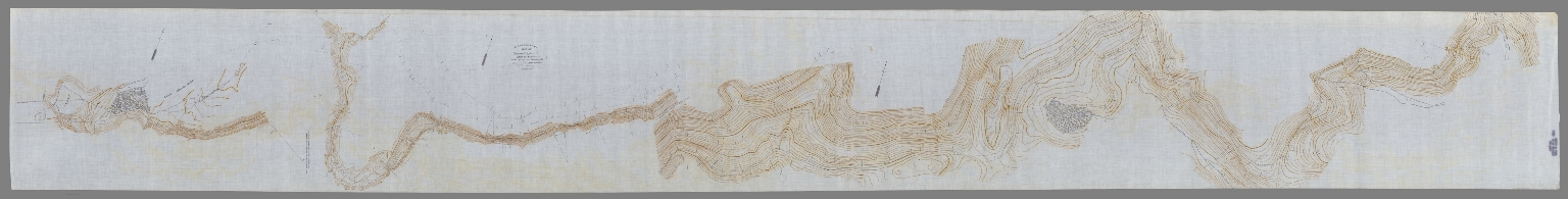
Colorado Ry. Co.
Full Title
Map of Preliminary Line "C.R." East of Range T.R. Countryman Eng. Traced Aug 1914 From Undated Plats Probably Run 1887 P-3015-26_2
List No
10293.000
Author
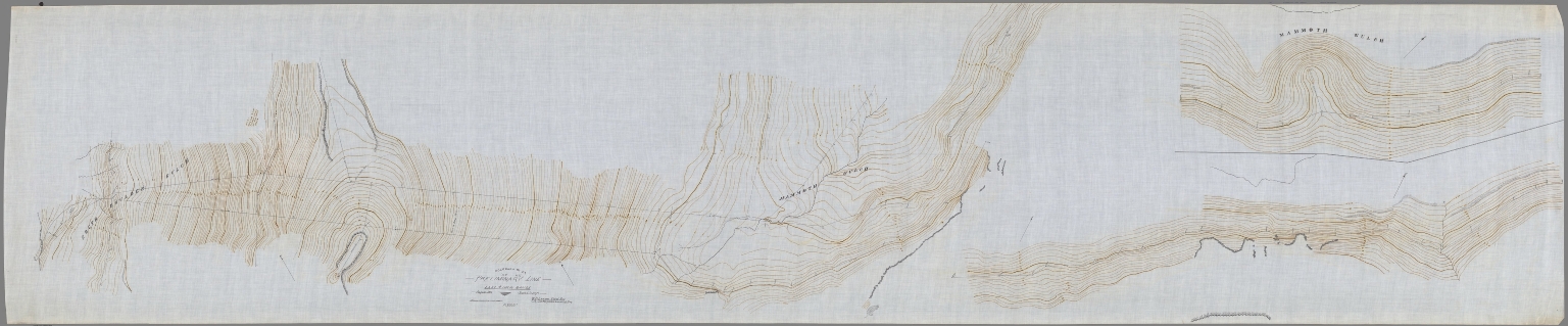
Colorado Ry. Co.
Full Title
Preliminary Line "H.T." "H.T.2" East of Main Range August 1886 W.B. Larson Chief Eng T.R. Countryman Locating Eng Traced August 1914 From Sheets. P-3015-26_1
List No
10294.000
Author
Cram, George Franklin
Full Title
Colorado.
List No
2809.030
Note
Locations of banking towns shown by red circles. Railroads are indicated by numbers and colors and patterns, and each railroad has the same number and color and pattern in every state through which it passes. All railroads on each map are in a list keyed to the map. Border of map has a table of contents for the atlas. Relief shown by hachures. Prime meridians Washington D.C. and Greenwich.
Author
Rand McNally and Company
Full Title
(Covers to) Rand, McNally & Co.'s Colorado. Rand McNally & Co., Map Publishers and Engravers, Chicago, 1907. Rand, McNally & Co.'s New Business Atlas Map of Colorado. Copyright, 1906, ... 1904 ... (with 33 page index) Rand, McNally & Co.'s Indexed County And Township Pocket Map And Shippers' Guide Of Colorado ... Chicago And New York: Rand, McNally & Co. ... (on verso) Copyright, 1907, by Rand, McNally & Co., Chicago.
List No
3379.001
Note
Same map as used in the New Business Atlas. 28 Colorado railroads shown. Catalogue for Rand McNally's "Indexed Pocket Maps of Foreign Countries," and their pocket maps of the United States and Canada. Full printed color by county, folded into brown card board covers 16.5x10.5 titled same as index. Includes index to Colorado Chief Cities and List of Colorado Railroads. The numbers in the list correspond to the numbers on the map. Prime meridian is Greenwich. Relief shown by hachures.
Author
Rand McNally and Company
Full Title
(Title Page to) Rand, McNally & Co.'s Colorado. Rand McNally & Co., Map Publishers and Engravers, Chicago, 1907. Rand, McNally & Co.'s New Business Atlas Map of Colorado. Copyright, 1906, ... 1904 ... (with 33 page index) Rand, McNally & Co.'s Indexed County And Township Pocket Map And Shippers' Guide Of Colorado ... Chicago And New York: Rand, McNally & Co. ... (on verso) Copyright, 1907, by Rand, McNally & Co., Chicago.
List No
3379.002
Note
Same map as used in the New Business Atlas. 28 Colorado railroads shown. Catalogue for Rand McNally's "Indexed Pocket Maps of Foreign Countries," and their pocket maps of the United States and Canada. Full printed color by county, folded into brown card board covers 16.5x10.5 titled same as index. Includes index to Colorado Chief Cities and List of Colorado Railroads. The numbers in the list correspond to the numbers on the map. Prime meridian is Greenwich. Relief shown by hachures.
Author
Rand McNally and Company
Full Title
Rand, McNally & Co.'s Colorado. Rand McNally & Co., Map Publishers and Engravers, Chicago, 1907. Rand, McNally & Co.'s New Business Atlas Map of Colorado. Copyright, 1906, ... 1904 ... (with 33 page index) Rand, McNally & Co.'s Indexed County And Township Pocket Map And Shippers' Guide Of Colorado ... Chicago And New York: Rand, McNally & Co. ... (on verso) Copyright, 1907, by Rand, McNally & Co., Chicago.
List No
3379.003
Note
Same map as used in the New Business Atlas. 28 Colorado railroads shown. Catalogue for Rand McNally's "Indexed Pocket Maps of Foreign Countries," and their pocket maps of the United States and Canada. Full printed color by county, folded into brown card board covers 16.5x10.5 titled same as index. Includes index to Colorado Chief Cities and List of Colorado Railroads. The numbers in the list correspond to the numbers on the map. Prime meridian is Greenwich. Relief shown by hachures.
Author
Rand McNally and Company
Full Title
(Covers to) Rand, McNally & Co.'s Colorado. Rand McNally & Co., Map Publishers and Engravers, Chicago, 1912. The Rand-McNally & Co.'s New Commercial Atlas Map of Colorado. Copyright by Rand-McNally & Co. (with 62 page index) Rand McNally & Co.'s Indexed County And Township Pocket Map And Shippers' Guide Of Colorado ... Chicago And New York: Rand McNally & Co. ... (on verso) Copyright, 1912, by Rand, McNally & Co., Chicago.
List No
3380.001
Note
Same map as used in the New Commercial Atlas. 32 Colorado railroads shown. Many ads for railroads, etc. after the index. Full printed color by county, folded into brown card board covers 17x10.5 printed with "The Rand-McNally Indexed County And Township Pocket Map And Shippers' Guide Of Colorado ... Rand McNally & Company Chicago, New York, Los Angeles." Includes index to Colorado Chief Cities and List of Colorado Railroads. The numbers in the list correspond to the numbers on the map. Prime meridian is Greenwich. Relief shown by hachures.
Author
Rand McNally and Company
Full Title
(Title Page to) Rand, McNally & Co.'s Colorado. Rand McNally & Co., Map Publishers and Engravers, Chicago, 1912. The Rand-McNally & Co.'s New Commercial Atlas Map of Colorado. Copyright by Rand-McNally & Co. (with 62 page index) Rand McNally & Co.'s Indexed County And Township Pocket Map And Shippers' Guide Of Colorado ... Chicago And New York: Rand McNally & Co. ... (on verso) Copyright, 1912, by Rand, McNally & Co., Chicago.
List No
3380.002
Note
Same map as used in the New Commercial Atlas. 32 Colorado railroads shown. Many ads for railroads, etc. after the index. Full printed color by county, folded into brown card board covers 17x10.5 printed with "The Rand-McNally Indexed County And Township Pocket Map And Shippers' Guide Of Colorado ... Rand McNally & Company Chicago, New York, Los Angeles." Includes index to Colorado Chief Cities and List of Colorado Railroads. The numbers in the list correspond to the numbers on the map. Prime meridian is Greenwich. Relief shown by hachures.
Author
Rand McNally and Company
Full Title
Rand, McNally & Co.'s Colorado. Rand McNally & Co., Map Publishers and Engravers, Chicago, 1912. The Rand-McNally & Co.'s New Commercial Atlas Map of Colorado. Copyright by Rand-McNally & Co. (with 62 page index) Rand McNally & Co.'s Indexed County And Township Pocket Map And Shippers' Guide Of Colorado ... Chicago And New York: Rand McNally & Co. ... (on verso) Copyright, 1912, by Rand, McNally & Co., Chicago.
List No
3380.003
Note
Same map as used in the New Commercial Atlas. 32 Colorado railroads shown. Many ads for railroads, etc. after the index. Full printed color by county, folded into brown card board covers 17x10.5 printed with "The Rand-McNally Indexed County And Township Pocket Map And Shippers' Guide Of Colorado ... Rand McNally & Company Chicago, New York, Los Angeles." Includes index to Colorado Chief Cities and List of Colorado Railroads. The numbers in the list correspond to the numbers on the map. Prime meridian is Greenwich. Relief shown by hachures.
Author
Cram, George Franklin
Full Title
Cram's Rail Road & Township Map of Colorado.
List No
4533.026
Author
Cram, George Franklin
Full Title
New Rail Road and County Map of Colorado.
List No
4558.047
Author
Cram, George Franklin
Full Title
Colorado.
List No
4727.029
Note
Prime meridians Washington D.C. and Greenwich. Relief shown by hachures. With printed color.
Author
Rand McNally and Company
Full Title
Commercial Atlas of America. Rand McNally Standard Map of Colorado.
List No
5028.130
Note
Shows railroads and distances. Includes tables of principal cities and railroads, keyed to map. Relief shown by hachures.
Author
Rand McNally and Company
Full Title
Commercial Atlas of America. Rand McNally Black and White Mileage Map, Utah and Colorado.
List No
5028.131
Note
Shows railroads and distances.
Author
Rand McNally and Company
Full Title
Commercial Atlas of America. Rand McNally Auto Trails Map, District No. 13. Montana, Wyoming, N.W. Colorado, East. Idaho, Nor. Utah, N.E. Nevada.
List No
5028.143
Note
Shows roads and distances. Shows table of highway names, numbers, and markings. Relief shown by hachures.
Author
Cram, George Franklin
Full Title
Cram's Rail Road & Township Map of Colorado. Published by Geo. F. Cram. Proprietor of the Western Map Depot. 66, Lake St. Chicago Ills. 1875.
List No
5370.028
Note
Map in full color by county. Railroad lines clearly shown. (Note: The map has been rotated 90 degrees clockwise for readability.)
Author
Rand McNally and Company
Full Title
(Covers to) Rand, McNally & Co.'s New Shippers' Railroad Map of the United States. Scale: 8 miles to one inch. Showing all railroads, each in a separate color, and all railroad stations in large, plain type. This is the Denver section, only, of the above-named map. (Below the neatline) Rand, McNally & Co.'s New Shippers' Railroad Map of the United States, Copyright, 1888 by Rand, McNally & Co. Copyright, 1891 by Rand, McNally & Co.
List No
5802E
Note
This is the Denver section of the larger map.
Author
Rand McNally and Company
Full Title
Rand, McNally & Co.'s New Shippers' Railroad Map of the United States. Scale: 8 miles to one inch. Showing all railroads, each in a separate color, and all railroad stations in large, plain type. This is the Denver section, only, of the above-named map. (Below the neatline) Rand, McNally & Co.'s New Shippers' Railroad Map of the United States, Copyright, 1888 by Rand, McNally & Co. Copyright, 1891 by Rand, McNally & Co.
List No
5802.005
Note
This is the Denver section of the larger map.
Author
[Westcott, Linn, Trains Magazine]
Full Title
Colorado Railroads.
List No
8846.003
Note
Color. Shaded relief. Includes numerous detailed map insets and a few vignettes.
1-29 of 29
|