|
REFINE
Browse All : Railroad of California and Nevada
1-20 of 20
Author
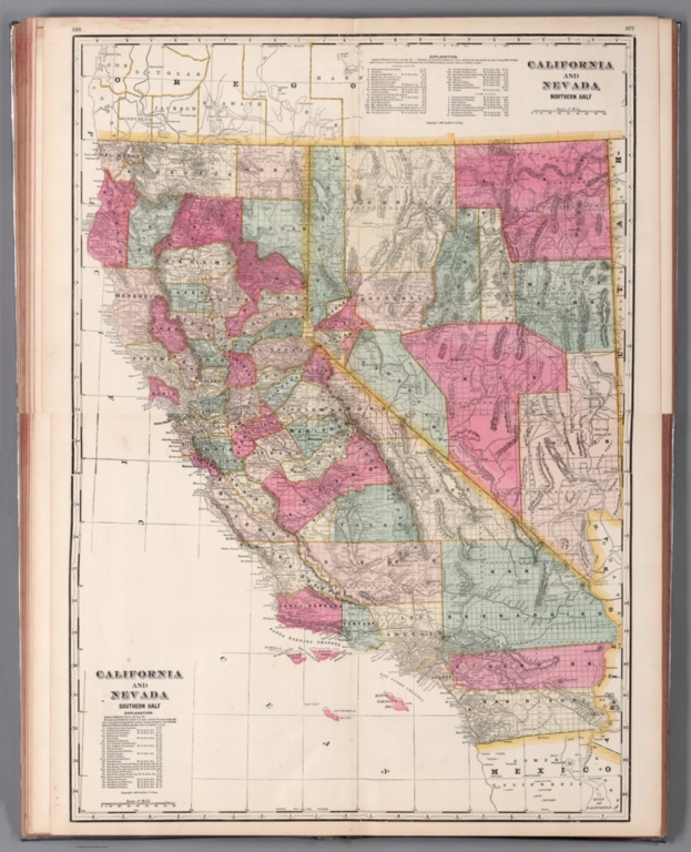
Cram, George Franklin, 1841-1928
Full Title
(Composite Map to) California and Nevada : Northern half. -- California and Nevada : Southern half. 1899, by Geo. F. Cram.
List No
14372.205
Note
Composite map of California and Nevada (northern and southern halves). Shows political boundaries, counties, towns, railroads, topography, bodies of water, drainage, coastlines and islands. Relief shown with hachures. Includes keys with explanations, latitudinal and longitudinal lines, as well as bar scales given in miles. With alphanumeric grid corresponding to "Index of Nevada" on page 371; "Index of California" on pages 374-375, 378-379 and 382. Colored lithograph. Together, maps are 82 x 57 cm, on two double sheets 90 x 67 cm. "Index of maps" and "Index of cities" in margins, providing navigation for atlas as a whole.
Author
Beckwith, E.G.
Full Title
From the Mud Lakes to the Pacific Ocean; from Explorations and Surveys made under the direction of the Hon. Jefferson Davis Secretary of War by Capt. E.G. Beckwith, 3d. Artillery. F.W. Egloffstein, Topographer for the Route. 1855. Explorations and surveys for a railroad route from the Mississippi River to the Pacific Ocean. War Department. Route near the 41st Parallel. Map No. 4. Selmar Siebert's Engraving & Printing Establishment. Washington, D.C.
List No
0693.031
Note
Uncolored map drawn in detail from Pyramid Lake in present-day Nevada to Mt. Shasta. The rest of the map is in sketchy detail.
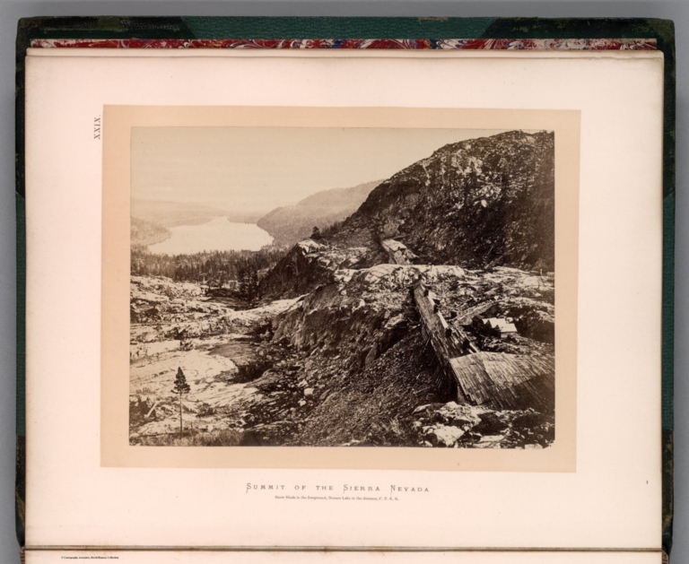
Hayden, Ferdinand Vandeveer, 1829-1887; ... XXIX. Summit of Sierra Nevada - snow she... 1870 13389.033 Related Author
[Hayden, Ferdinand Vandeveer, 1829-1887, Russell, Andrew Joseph, 1830-1902]
Full Title
Summit of Sierra Nevada - snow sheds in foreground, Donner Lake in the distance, C. P. R.R. (to accompany) Sun pictures of Rocky Mountain scenery ... by F. V. Hayden, ... New York : Julius Bien, 1870.
List No
13389.033
Note
Black and white view, shows snow sheds over railroad tracks between tunnels in the Sierra Nevada, with Donner Lake in the distance.
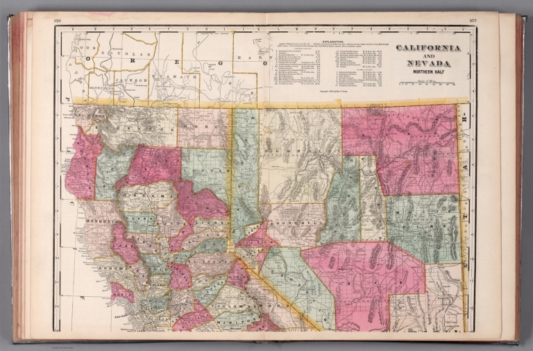
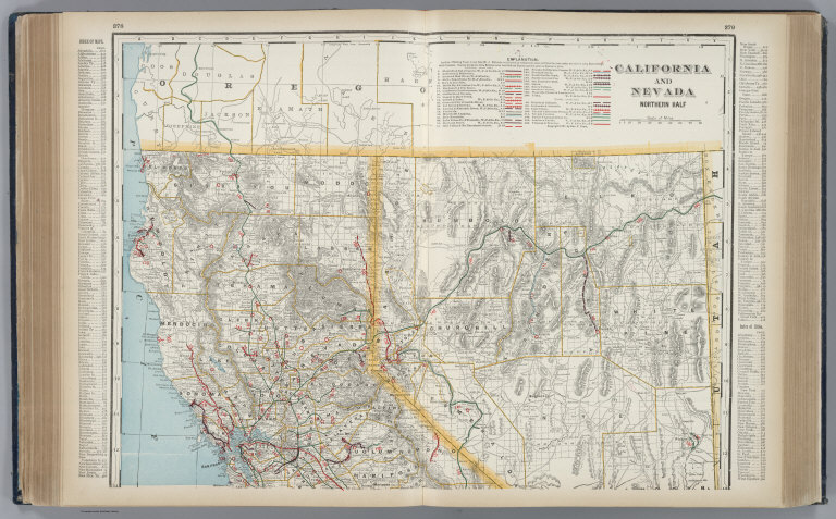
Author
Cram, George Franklin, 1841-1928
Full Title
California and Nevada : Northern half. 1899, by Geo. F. Cram.
List No
14372.202
Note
Map of California and Nevada (northern half). Shows political boundaries, counties, towns, railroads, topography, bodies of water, drainage, coastlines and islands. Relief shown with hachures. Includes key with explanation, latitudinal and longitudinal lines, as well as a bar scale given in miles. With alphanumeric grid corresponding to "Index of Nevada" on page 371; "Index of California" on pages 374-375, 378-379 and 382. Colored lithograph. Map is 41 x 57 cm, on double sheet 45 x 67 cm. "Index of maps" and "Index of cities" in margins, providing navigation for atlas as a whole. Southern half of map follows on pages 380-381.
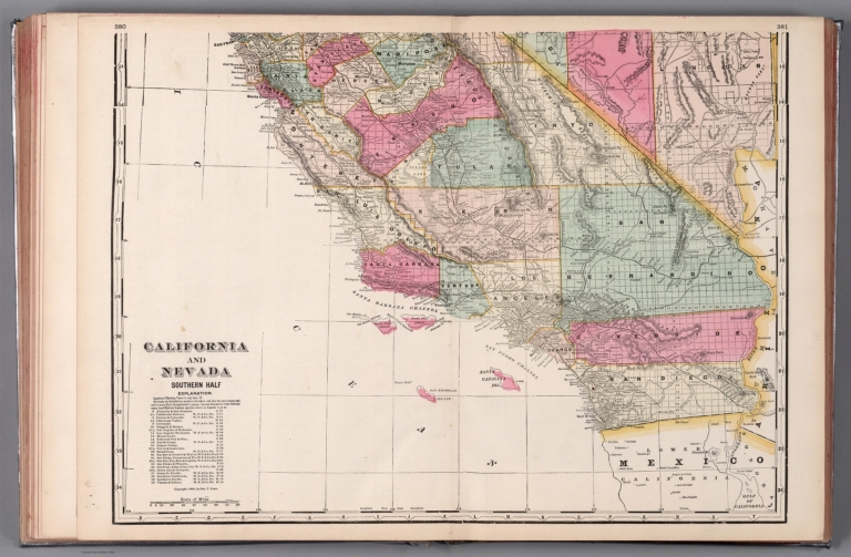
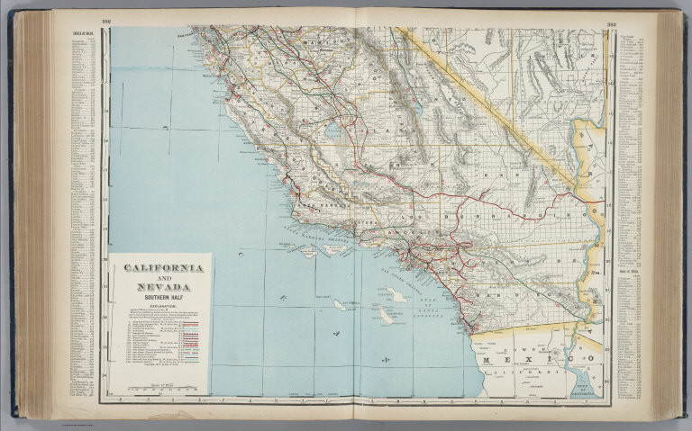
Author
Cram, George Franklin, 1841-1928
Full Title
California and Nevada : Southern half. 1899, by Geo. F. Cram.
List No
14372.204
Note
Map of California and Nevada (southern half). Shows political boundaries, counties, towns, railroads, topography, bodies of water, drainage, coastlines and islands. Relief shown with hachures. Includes key with explanation, latitudinal and longitudinal lines, as well as a bar scale given in miles. With alphanumeric grid corresponding to "Index of Nevada" on page 371; "Index of California" on pages 374-375, 378-379 and 382. Colored lithograph. Map is 41 x 56 cm, on double sheet 45 x 67 cm. "Index of maps" and "Index of cities" in margins, providing navigation for atlas as a whole. Northern half of map precedes on pages 376-377.
Author
Cram, George Franklin
Full Title
California and Nevada, Northern Half.
List No
2809.057
Note
Locations of banking towns shown by red circles. Railroads are indicated by numbers and colors and patterns, and each railroad has the same number and color and pattern in every state through which it passes. All railroads on each map are in a list keyed to the map. Border of map has a table of contents for the atlas. Relief shown by hachures. Prime meridians Washington D.C. and Greenwich.
Author
Cram, George Franklin
Full Title
California and Nevada, Southern Half.
List No
2809.058
Note
Locations of banking towns shown by red circles. Railroads are indicated by numbers and colors and patterns, and each railroad has the same number and color and pattern in every state through which it passes. All railroads on each map are in a list keyed to the map. Border of map has a table of contents for the atlas. Relief shown by hachures. Prime meridians Washington D.C. and Greenwich.
Author
Cram, George Franklin
Full Title
(Composite of) California and Nevada.
List No
2809.059
Note
Locations of banking towns shown by red circles. Railroads are indicated by numbers and colors and patterns, and each railroad has the same number and color and pattern in every state through which it passes. All railroads on each map are in a list keyed to the map. Border of map has a table of contents for the atlas. Relief shown by hachures. Prime meridians Washington D.C. and Greenwich.
Author
[Frey, A.C., Nell, Louis]
Full Title
Topographical Railroad & County Map Of The States Of California And Nevada Compiled from the latest explorations and other official information by L. Nell, N.Y. Published by A.C. Frey & Co 204 Fulton St. New York. General Agents for California A. Roman & Co. 417 & 419 Montgomery St. San Francisco. Ferd. Mayer & Co. Lithographers, 96 Fulton St. N.Y. Entered ... 1868 by Frey & Nell ... New York. (inset) Map of the City of San Francisco, California. (inset) Map Of The Great National Pacific Railroads.
List No
3440.000
Note
Wheat writes several pages about this map, being impressed with its up to date cartography. Williamson's proposed route through the Owyhee to the Idaho mines is shown, as well as much current detail in central Nevada and all of California. The influence of Williamson's 1866 "Map of Parts of California, Nevada, Oregon and Idaho Territory" (both the published and the ms version) is obvious. A wheel shows the "Difference of time between S. Francisco and other important Cities." This may be Louis Nell's first commercial map, before his extensive work for the Wheeler Survey in the 1870's and his Colorado maps of the 1880's. The railroad map shows the Union Pacific completed to Cheyenne and the Central Pacific to the Nevada border. This is both a beautiful map and an excellent depiction of California and Nevada just before the completion of the railroad. Wheat mentions that the towns of the Humboldt valley are sprinkled with names that disappear in a few years with the coming of the railroad. Full color by county.
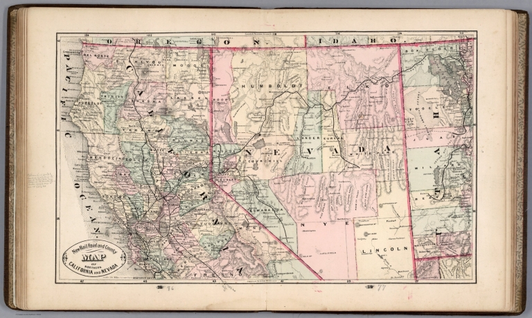
Author
Cram, George Franklin
Full Title
New Rail Road and County Map of Northern California and Nevada.
List No
4558.056
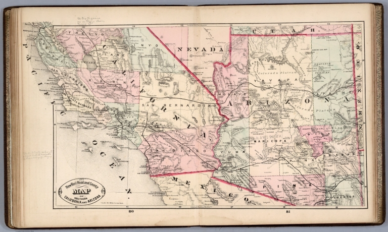
Author
Cram, George Franklin
Full Title
New Rail Road and County Map of Southern California and Arizona.
List No
4558.058
Author
Gray, Ormando Willis
Full Title
Gray's Atlas New Railroad and County Map of the States of Oregon, California, and Nevada Compiled and Drawn by Frank A. Gray. Published by O.W. Gray, Philadelphia. (inset) Enlarged Plan of the Vicinity of San Francisco and Sacramento.
List No
4740.060
Author
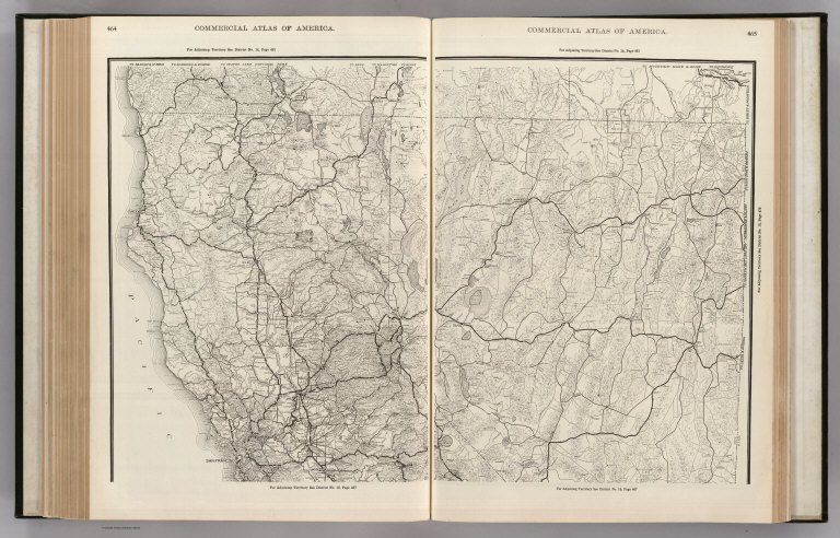
Rand McNally and Company
Full Title
Commercial Atlas of America. Rand McNally Black and White Mileage Map, California and Nevada.
List No
5028.134
Note
Shows railroads and distances. Includes steamship lines and routes. Insets of the San Francisco Bay Area and Los Angeles region.
Author
Rand McNally and Company
Full Title
Commercial Atlas of America. (Rand McNally Auto Trails Map, District No. 15-16. California, Nevada. Northern Section).
List No
5028.138
Note
Shows roads and distances. Relief shown by hachures.
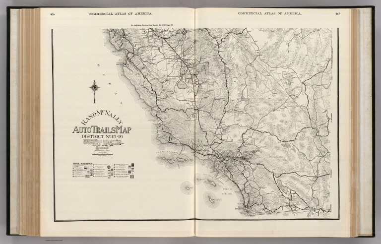
Author
Rand McNally and Company
Full Title
Commercial Atlas of America. Rand McNally Auto Trails Map, District No. 15-16. (California, Nevada. Southern Section).
List No
5028.139
Note
Shows roads and distances. Shows table of highway names, numbers, and markings. Relief shown by hachures.
Author
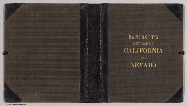
Bancroft, A.L.
Full Title
Bancroft's new map of California and Nevada : compiled from the latest and most reliable official sources and special surveys.
List No
6724.001
Note
Includes a unique birdseye view of Virginia City, Nevada. This map derives from H. H. Bancroft's 1867 Map of the Pacific States (see our 2549.000) but now focuses on just California and Nevada and the extensive and growing mining activity and transportation networks in those states. It is an entirely new engraving from the earlier map series and uses color lithography. With an inset map, Railway Map of the Pacific States.
Author
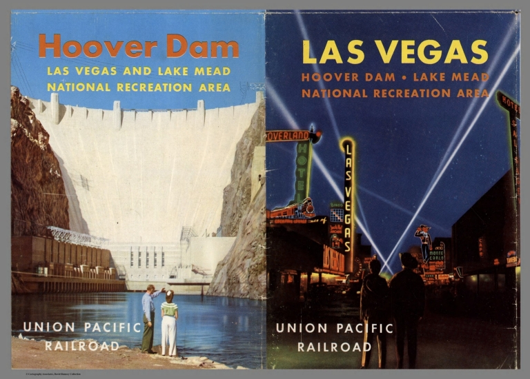
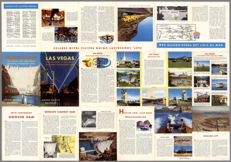
Eddy, Gerald A. (1890-1967)
Full Title
(Covers to) Panoramic Perspective of the Area Adjacent to Las Vegas - Hoover Dam and Lake Mead Recreational Area. Served by Union Pacific Railroad. Copyright 1953 for Union Pacific Railroad. (drawn by) Gerald A. Eddy - Glendale, Calif.
List No
8607.001
Note
Colored birds eye view of the area around the proposed Hoover Dam. Shows state boundaries, boundary of National recreation area, and approximate boundary of Atomic testing grounds, railroads, highways, some distances, cities and towns. Relief shown pictorially and by spot heights. Depth shown by soundings.
Author
Eddy, Gerald A. (1890-1967)
Full Title
(Text page to) Panoramic Perspective of the Area Adjacent to Las Vegas - Hoover Dam and Lake Mead Recreational Area. Served by Union Pacific Railroad. Copyright 1953 for Union Pacific Railroad. (drawn by) Gerald A. Eddy - Glendale, Calif.
List No
8607.002
Note
Colored birds eye view of the area around the proposed Hoover Dam. Shows state boundaries, boundary of National recreation area, and approximate boundary of Atomic testing grounds, railroads, highways, some distances, cities and towns. Relief shown pictorially and by spot heights. Depth shown by soundings.
Author
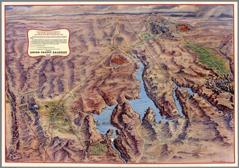
Eddy, Gerald A. (1890-1967)
Full Title
Panoramic Perspective of the Area Adjacent to Las Vegas - Hoover Dam and Lake Mead Recreational Area. Served by Union Pacific Railroad. Copyright 1953 for Union Pacific Railroad. (drawn by) Gerald A. Eddy - Glendale, Calif.
List No
8607.003
Note
Colored birds eye view of the area around the proposed Hoover Dam. Shows state boundaries, boundary of National recreation area, and approximate boundary of Atomic testing grounds, railroads, highways, some distances, cities and towns. Relief shown pictorially and by spot heights. Depth shown by soundings.
Author
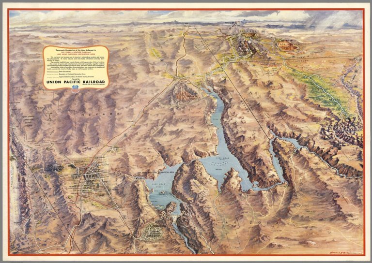
Eddy, Gerald A. (1890-1967)
Full Title
Panoramic Perspective of the Area Adjacent to Las Vegas - Hoover Dam and Lake Mead Recreational Area. Served by Union Pacific Railroad. Copyright 1961 for Union Pacific Railroad. (drawn by) Gerald A. Eddy - Glendale, Calif.
List No
8608.000
Note
Colored birds eye view of the area around the proposed Hoover Dam. Shows state boundaries, boundary of National recreation area, and approximate boundary of Atomic testing grounds, railroads, highways, some distances, cities and towns. Relief shown pictorially and by spot heights. Depth shown by soundings.
1-20 of 20
|