|
REFINE
Browse All : Railroad of Alaska
1-13 of 13
Author
Cram, George Franklin, 1841-1928
Full Title
Alaska. 1899, by Geo. F. Cram.
List No
14372.238
Note
Map of Alaska. Shows political boundaries, districts, towns, railroads, topography, glaciers, bodies of water, drainage, coastlines and islands. Relief shown with hachures. Includes key with explanation, latitudinal and longitudinal lines, as well as a bar scale given in miles. Three inset maps: Cook Inlet -- Yukon River -- Klondike District. With alphanumeric grid corresponding to "Index of Alaska" on page 427. Colored lithograph. Map is 40 x 56 cm, on double sheet 45 x 67 cm. "Index of maps" and "Index of cities" in margins, providing navigation for atlas as a whole.
Author
Canadian National Railways
Full Title
Alaska and the Yukon -- Routes of Canadian National Pacific Coast Services, Canadian National Steamship Company Ltd.
List No
14461.003
Note
Two maps of the Alaska and the Yukon, as well as the railway lines of the Canadian National Pacific Coast Services and the steamship lines of the Canadian National Steamship Company Ltd. Maps also show political boundaries, cities, parks, topography, bodies of water, drainage, coastlines and islands. Relief shown with shading. Includes descriptive text. Colored lithograph. Together, maps are 75 x 42 cm, on sheet 77 x 44 cm.
Author
Northern Pacific Railway Company
Full Title
(Text Page to) The Yellowstone National Park via Northern Pacific Railway. Northern Pacific, Yellowstone Park Line. Puget Sound and Alaska. (inset) Northern Pacific Railway and connections. Poole Bros., Chicago. (inset of steamship routes to southeastern Alaska from Puget Sound)
List No
4118C
Note
Two maps plus the photos and text regarding Yellowstone and Alaska.
Author
Leahy, J.F.
Full Title
(Index to) Leahy's Hotel Guide and Railway Distance Maps. Saskatchewan, Manitoba, Alaska U.S.A.
List No
0425.142
Note
Alphabetical index list of the Hotels of the towns with the number of rooms of each, their rates per day and the population of the towns. Includes population of the states, and explanation of abbreviation of the railroad of the states.
Author
Leahy, J.F.
Full Title
British Columbia. Alberta. Saskatchewan. Manitoba. (inset) Alaska.
List No
0425.143
Note
Map printed without color. Includes name of the railroad entering the town, and distance between towns.
Author
Jorgensen, Gotfred Emile
Full Title
Map of the Province of British Columbia. Compiled by direction of the Honourable G.B. Martin, Chief Commissioner of Lands and Works Victoria, B.C. 1895. Compiled and drawn in the Department of Lands and Works. Gotfred Jorgensen C.E. Sabiston Lith. & Pub. Co. Montreal. Edward Stanford.
List No
13236.002
Note
Color map on sheet 120x141, dissected and folded into 20x14, with insets: Graphic outline of the Dominion of Canada, showing relative position of British Columbia; Map showing geographical relation between Canada and Europe. Map shows the boundary line with the Alaskan Panhandle. settlements, roads, railways, old land recording districts, numbered sections, post offices, administrative offices, and First Nations settlements. A user has updated the map with a large number of town names. Relief shown by shading, Prime meridian is Greenwich. On cover: London: Edward Stanford publication advertisement.
Author
New England Railway Publishing Company
Full Title
ABC, The pathfinder railway guide map : Western section. Issued by the New England Railway Publishing Company, 67 Federal St., Boston, Mass. Copyright, 1902.
List No
14042.000
Note
Map of the United States showing railroads in red lines, with stations. Map 70 x 108 cm, on sheet 77 x 115 cm. With 5 insets: Alaska -- Yellowstone Park -- Philippine Islands -- Guam -- Hawaiian Islands.
Author
White Pass & Yukon Route
Full Title
(Covers to) Map Of White Pass & Yukon Route And Connections. White Pass & Yukon Route ... Copyright, 1917, by White Pass & Yukon Route. (inset) Map of Atlin Lake District. Poole Bros. Chicago. (Ed. of) 4-10-'22.
List No
2384A
Author
White Pass & Yukon Route
Full Title
Map Of White Pass & Yukon Route And Connections. White Pass & Yukon Route ... Copyright, 1917, by White Pass & Yukon Route. (inset) Map of Atlin Lake District. Poole Bros. Chicago. (Ed. of) 4-10-'22.
List No
2384.001
Note
Modelski shows a 1919 map by Poole Bros. Excellent map showing Alaska and the Yukon. Printed in full color and folded into brown card board covers 20x11 printed with "White Pass & Yukon Route. Map Of Alaska, Atlin And The Yukon Issued By White Pass & Yukon Route ..." on the front cover and a table of distances on the back.
Author
Cram, George Franklin
Full Title
Alaska. (insets) Cook Inlet and Vicinity; Birch Creek and Tributaries; Klondike District.
List No
2809.068
Note
No counties shown. Relief shown by hachures. Prime meridians Washington D.C. and Greenwich.
Author
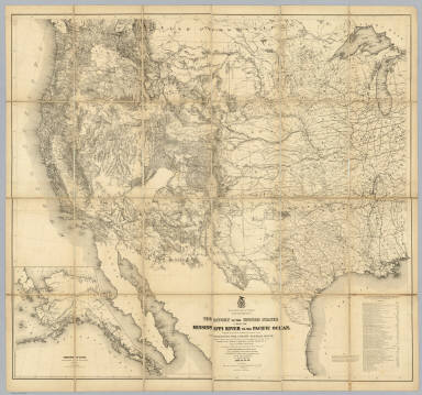
[Freyhold, Edward, Warren, Gouverneur Kemble, 1830-1882]
Full Title
Territory Of The United States From The Mississippi River To The Pacific Ocean; Originally prepared to accompany the Reports of the Explorations For A Pacific Railroad Route ... Compiled from authorized explorations and other reliable data by Lieut. G.K. Warren, Top'l. Eng'rs. In the Office of Pacific R.R. Surveys, War Dept. under the direction of Bvt. Maj. W.H. Emory, Top'l. Eng'rs. in 1854. Capt. A.A. Humphreys, Top'l. Eng'rs. in 1854-58. Recompiled and redrawn under the direction of the Chief of Corps of Engineers By Edward Freyhold 1865-66-67-68. Head Quarters Corp Of Engineers, War Department. Engraved & printed by Julius Bien, N.Y. (inset) Territory Of Alaska Ceded By Russia To The United States 1868.
List No
2919.000
Note
Alaska inset; 59 "authorities"; Streeter copy. Wheat: "one of the great American maps, and one profoundly influential." The final revision of the original Warren map of 1857; largely redrawn, in substance, and style of hachuring. An earlier state of the same imprint is described in Streeter 3080. See Wheeler vol 1 reference. In 1879 Freyhold issued another larger version of this map (Wheat 1295) (see our copy). Without color. Dissected into 24 sections and mounted on linen. Folds into a new burgundy cloth folding case 30x22 with original spine label reading "Freyhold - Map Of Explorations For Pacific R.R. - Recompiled 1865-68."
Author
Cram, George Franklin
Full Title
Alaska, Geo. F. Cram, Engraver & Publisher, Chicago, Ill. (inset) Aleutian Islands (continuation of main map).
List No
4727.072
Note
Prime meridians Washington D.C. and Greenwich. Relief shown by hachures. With printed color.
Author
Rand McNally and Company
Full Title
Commercial Atlas of America. Rand McNally Standard Map of Alaska.
List No
5028.153
Note
Shows railroads and distances. Includes tables of principal cities and railroads, keyed to map. Relief shown by hachures. Inset of Aleutian Islands is a continuation of main map.
1-13 of 13
|