|
REFINE
Browse All : Railroad from 1926
1-5 of 5
Author
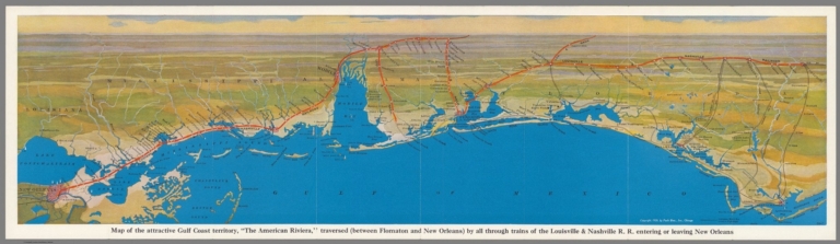
Louisville & Nashville R.R.
Full Title
Map of the attractive Gulf Coast territory, "The American Riviera" traversed (Between Flomaton and New Orleans) by all through trains of the Louisville & Nashwille R.R. entering or leaving New Orleans. Copyright 1926, by Pool Bros., Inc. Chicago. (Cover title) Between the north and New Orleans : via the beautiful Gulf Coast, Over the Louisville & Nashville R.R.
List No
11140.002
Note
Panoramic map of the Gulf Cost "The American Riviera" on sheet 23x81, folded into 23x10 Showing the Louisville & Nashville railroad route from New Orleans to Apalachicola. Includes place names, cities and towns. On verso: pictorial cover, text: "The Louisville & Nashville Railroad", uncolored route map, black and white photos of scenic views.
Author
[James, Kerns & Abbott Co., Southern Pacific Lines]
Full Title
Southern Pacific Lines.
List No
12457.003
Note
Date estimated.
Author
[Southern Pacific Lines, Gifford]
Full Title
(Composite Text) Southern Pacific Lines.
List No
12457.004
Note
Date estimated.
Author
Neurath, Otto, 1882-1945
Full Title
Entwicklung der Eisenbahnen : 1825 -- 1851 -- 1881 -- 1901 -- 1913 -- 1926. Angefertigt für das Bibliographische Institut AG., Leipzig. Gesellschafts- und Wirtschaftsmuseum in Wien. ©
List No
14080.060
Note
Colored map, with diagram showing the development of railways across the world, from 1825 to 1926. Includes a legend. Map, with diagram, is 20 x 34, on sheet 31 x 46 cm. Information depicted with Isotype (International system of typographic picture education), a method for assembling, configuring and disseminating information and statistics through pictorial means, invented by Otto and Marie Neurath.
Author
Railroad Commission of the State of California
Full Title
1926 Edition Of The Official Railroad Map Of California. Issued by Railroad Commission Of The State Of California. State Building, San Francisco ... Compiled by the Railroad Commission of the State of California, Engineering Department, Lester S. Ready, Chief Engineer. J.W. Clement Co., Buffalo, N.Y. (with 4 inset maps).
List No
2777.000
Note
Similar but different from Scarborough's California Map. Insets of San Francisco, Los Angeles, Sacramento and San Diego. Key indicates "Aero" landing fields of several types. Shows Steam and electric railway lines in operation, national parks and forests and distances from San Francisco. Map is printed in full color. Relief shown by spot heights and shading.
1-5 of 5
|