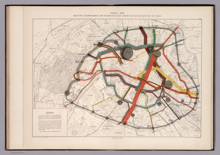
Bertillon, Jacques, 1851-1922; Seine. Se... Paris 1888 : Recette kilometriques des t... 1888 13101.019 Related Author
[Bertillon, Jacques, 1851-1922, Seine. Service de la statistique municipale]
Full Title
Paris 1888 : Recette kilometriques des tramways et chemin de fer de ceinture de Paris. A. Baudry del. Grave chez L. Wuhrer. Imp. Lemercier et Cie. (to accompany) Atlas de statistique graphique de la ville de Paris. I-II. Annee 1888. Paris : G. Masson,1889.
List No
13101.019
Note
Map of Paris on 2 sheets. Showing the average line length of the tramway and railway systems of Paris. Includes notes and legend.
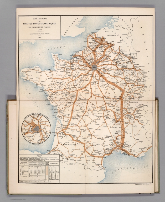
Ministere des Travaux Publics; Cheysson,... Carte Figurative des Recettes Brutes Kil... 1889 12519.009 Related Author
[Ministere des Travaux Publics, Cheysson, Émile]
Full Title
Carte Figurative des Recettes Brutes Kilometriques des Chemins de Fer Francais en 1887. (Gross earnings of the French railroads in 1887.)
List No
12519.009
Note
Graph type: flow.
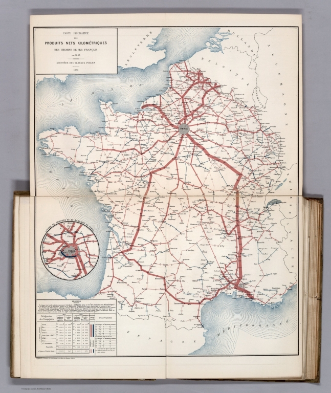
Ministere des Travaux Publics; Cheysson,... Carte Figurative des Produits Nets Kilom... 1889 12519.010 Related Author
[Ministere des Travaux Publics, Cheysson, Émile]
Full Title
Carte Figurative des Produits Nets Kilometriques des Chemins de Fer Francais en 1887. (Net products of the French railroads in 1887.)
List No
12519.010
Note
Graph type: flow.
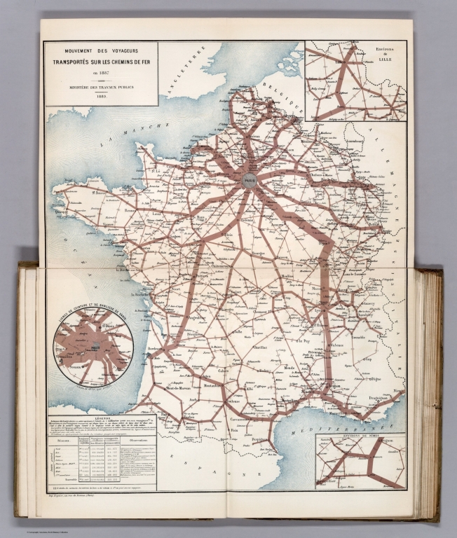
Ministere des Travaux Publics; Cheysson,... Mouvement des Voyageurs Transportes sur ... 1889 12519.011 Related Author
[Ministere des Travaux Publics, Cheysson, Émile]
Full Title
Mouvement des Voyageurs Transportes sur les Chemins de Fer en 1886. (Number of travellers transported via the French railroads in 1886.)
List No
12519.011
Note
Graph type: flow.
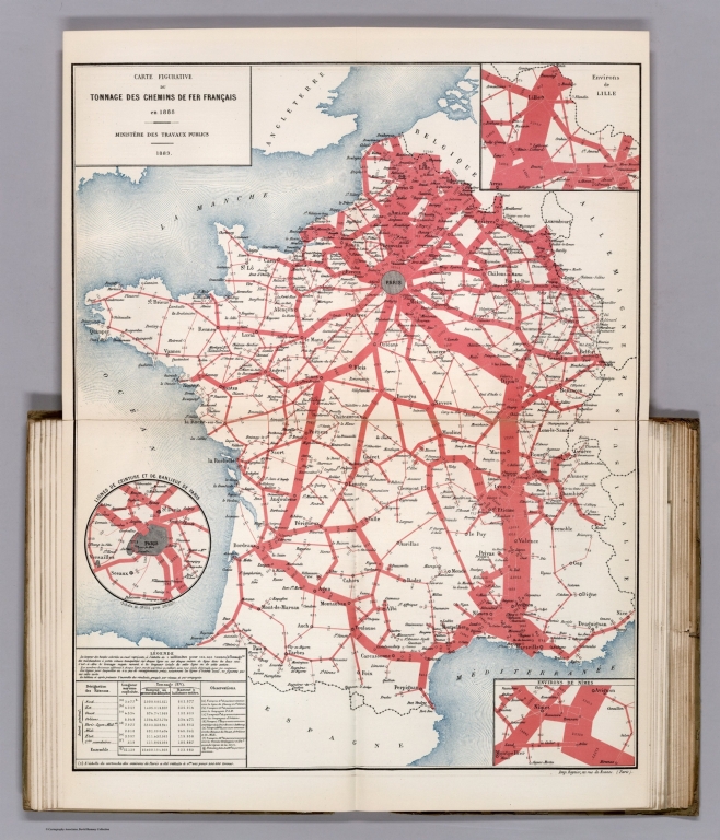
Ministere des Travaux Publics; Cheysson,... Carte Figurative du Tonnage des Chemins ... 1889 12519.012 Related Author
[Ministere des Travaux Publics, Cheysson, Émile]
Full Title
Carte Figurative du Tonnage des Chemins de Fer Francais en 1886. (Tonnage of the French railroads in 1886.)
List No
12519.012
Note
Graph type: flow.
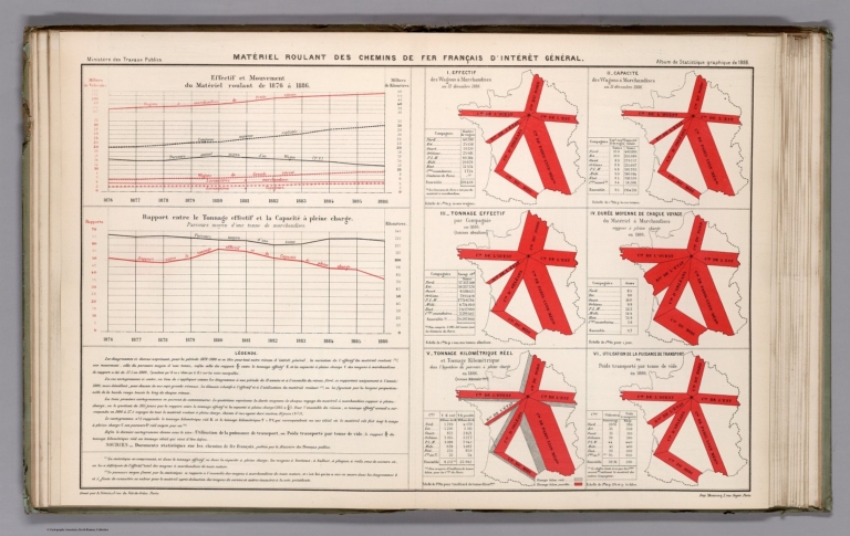
Ministere des Travaux Publics; Cheysson,... Statistical Diagram: Materiel Roulant de... 1889 12519.013 Related Author
[Ministere des Travaux Publics, Cheysson, Émile]
Full Title
(Statistical Diagram) Materiel Roulant des Chemins de Fer Francais D'Interet General. (Materials of général interest transported by the railroads.)
List No
12519.013
Note
Graph type: flow, line graph, bar.
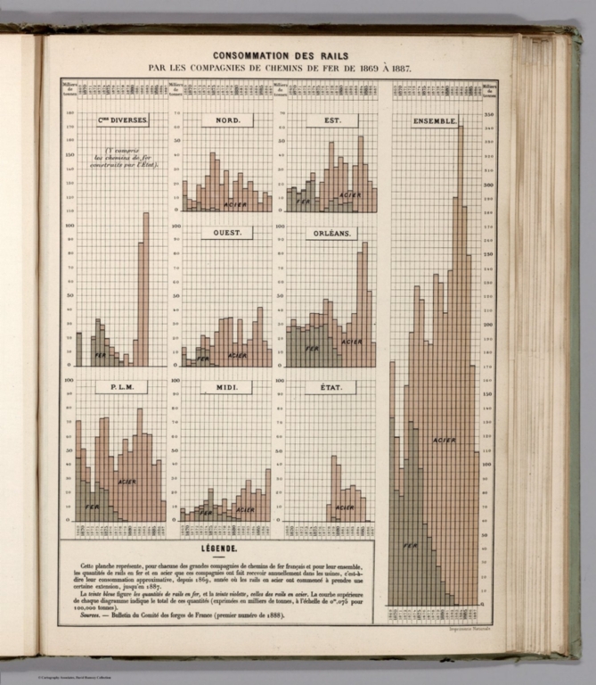
Ministere des Travaux Publics; Cheysson,... Statistical Diagram: Consommation des Ra... 1889 12519.014 Related Author
[Ministere des Travaux Publics, Cheysson, Émile]
Full Title
(Statistical Diagram) Consommation des Rails par les Compagnies de Chemins de Fer de 1869 a 1887. (Usage of the rails between 1869 and 1889.)
List No
12519.014
Ministere des Travaux Publics; Cheysson,... Carte Figurative des Produits Nets Kilom... 1889 12520.016 Related Author
[Ministere des Travaux Publics, Cheysson, Émile]
Full Title
Carte Figurative des Produits Nets Kilometriques des Chemins de Fer Francais en 1888. (Net kilometric products of the French railroads in 1888.)
List No
12520.016
Note
Graph type: flow.
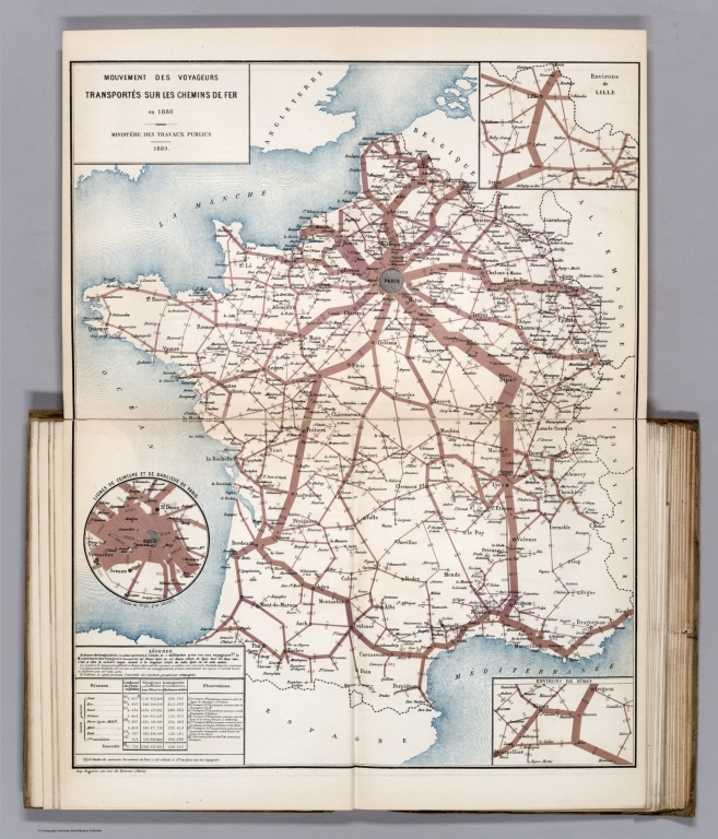
Ministere des Travaux Publics; Cheysson,... Mouvement des Voyageurs Transportes sur ... 1889 12520.017 Related Author
[Ministere des Travaux Publics, Cheysson, Émile]
Full Title
Mouvement des Voyageurs Transportes sur les Chemins de Fer en 1887. (Movement of the travellers transported via the French railroads in 1887.)
List No
12520.017
Note
Graph type: flow.
Ministere des Travaux Publics; Cheysson,... Mouvement des Voyageurs Transportes sur ... 1889 12520.018 Related Author
[Ministere des Travaux Publics, Cheysson, Émile]
Full Title
Mouvement des Voyageurs Transportes sur les Chemins de Fer en 1888. (Movement of the travellers transported via the French railroads in 1888.)
List No
12520.018
Note
Graph type: flow.
Ministere des Travaux Publics; Cheysson,... Carte Figurative du Tonnage des Chemins ... 1889 12520.019 Related Author
[Ministere des Travaux Publics, Cheysson, Émile]
Full Title
Carte Figurative du Tonnage des Chemins de Fer Francais en 1887. (Tonnage of the French railroads in 1887.)
List No
12520.019
Note
Graph type: flow.
Ministere des Travaux Publics; Cheysson,... Carte Figurative du Tonnage des Chemins ... 1889 12520.020 Related Author
[Ministere des Travaux Publics, Cheysson, Émile]
Full Title
Carte Figurative du Tonnage des Chemins de Fer Francais en 1888. (Tonnage of the French railroads in 1888.)
List No
12520.020
Note
Graph type: flow.
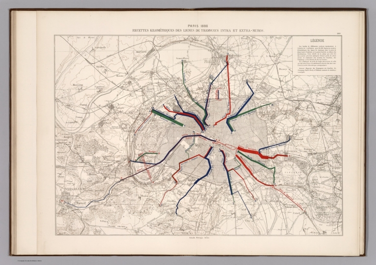
Bertillon, Jacques, 1851-1922; Seine. Se... Paris 1888 : Recette kilometriques des l... 1888 13101.020 Related Author
[Bertillon, Jacques, 1851-1922, Seine. Service de la statistique municipale]
Full Title
Paris 1888 : Recette kilometriques des ligns de tramways intra et extra - muros. A. Baudry del. (to accompany) Atlas de statistique graphique de la ville de Paris. I-II. Annee 1888. Paris : G. Masson,1889.
List No
13101.020
Note
Map of Paris on 2 sheets. Showing the average line length of the intera and extera mural tramway system of Paris. Includes notes and legend.
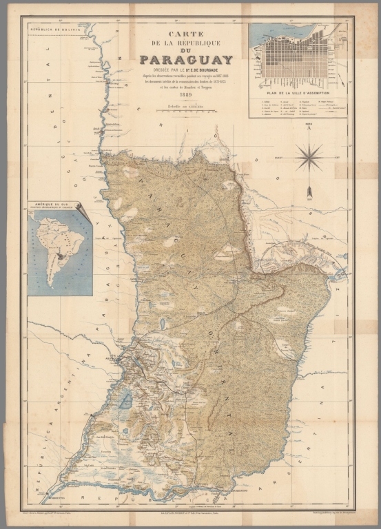
Author
Bourgade La Dardye, E. de
Full Title
Carte de la Republique du Paraguay : dressee par E. de Bourgade. D'apres les observations recueillies pendant ves voyages en 1887-1888 les documetns inedits de la comission des limites de 1871-1873 et les cartes de Mouchez et Toeppen 1889. Grave chez L. Sonnet, Paris. Imp. Dufrenoy.
List No
13287.000
Note
"A French Proposal For A Railway Between Asuncion and Santos, Brazil Bourgade La Dardye, Emmanuel de.Carte de La Republique du Paraguay Dressee Par Le Dr. E. De. Bourgade d'pares les observations recueilles pendand ses voyages en 1887-1888 les documetns inedits de la comission des limites de 1871-1873 et les cartes de Mouchez et Toeppen 1889. 1889. Paris. 901 x 635 mm. Detailed map of The Republic of Paraguay by Dr. E. De Bourgade, published in Paris in 1889. The map provides a detailed treatment of the existing roads and railroads in Paraguay, and includes large inset map of the Asuncion, the capital of Paraguay. The map is based upon the observations made by De Bourgade during his travels in 1887-1888, as well as unpublished documents from the boundary commission of 1871-1873 and maps of Mouchez and Toeppen. The map illustrates in great detail the proposed line of a transcontinental railroad, which was then being proposed by french businessmen. Bourgade was a French scientist, who came to Paraguay in 1887, along with Viscount Emmanuel Obert de Thiensis and Henry Rochefort. Bourgade travelled extensively within the country, before publishing a book on his travels in 1889. Thiensis was the representative of French businessman Leonce de Modave de Masogne, who had obtained a concession from the Paraguay Government to construct a railroad between Asuncion and Santos, Brazil and to establish Sugar, Rum Molasses and other factories." (HS Books)
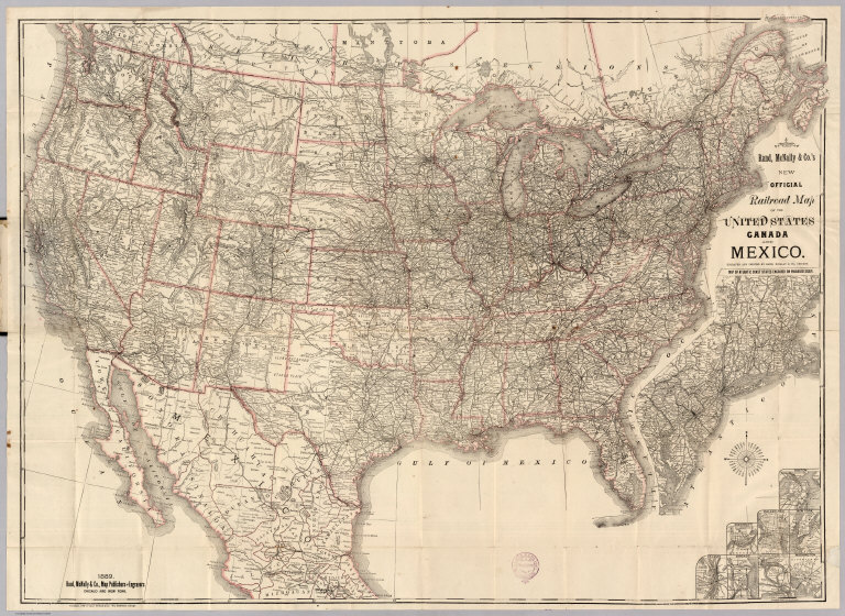
Smith, J.L.; Rand McNally and Company Covers: Railroad Map Of The United State... 1889 4090.001 Related Author
[Rand McNally and Company, Smith, J.L.]
Full Title
(Covers to) Rand, McNally & Co.'s New Official Railroad Map Of The United States, Canada And Mexico. Engraved And Printed By Rand, McNally & Co., Chicago. 1889. Rand, McNally & Co., Map Publishers and Engravers, Chicago And New York. Copyright, 1889, by Rand, McNally & Co. Map Publishers, Chicago. (inset) Map Of Atlantic Coast States Engraved On Enlarged Scale. (with 8 additional inset maps).
List No
4090.001
Note
An example of J.L. Smith issuing Rand McNally maps. On the map is a red rubber stamp with Smith's name and logo. The map is classic Rand McNally for the period, showing railroads only in the eastern half of the U.S. and railroads and roads in the less settled western half. This is a later, enlarged (into Mexico) issue of the 1883 Rand/Dripps U.S. (our #3259). Eight small insets are titled: Boston, New York, Philadelphia, Cincinnati, St. Louis, Chicago, Buffalo & Niagara Falls, and Washington. Outline color by state, map folded into black cloth covers 16x11 with label reading "Map Of The United States And Territories J.L. Smith." Prime meridian is Washington D.C.
Author
[Rand McNally and Company, Smith, J.L.]
Full Title
Rand, McNally & Co.'s New Official Railroad Map Of The United States, Canada And Mexico. Engraved And Printed By Rand, McNally & Co., Chicago. 1889. Rand, McNally & Co., Map Publishers and Engravers, Chicago And New York. Copyright, 1889, by Rand, McNally & Co. Map Publishers, Chicago. (inset) Map Of Atlantic Coast States Engraved On Enlarged Scale. (with 8 additional inset maps).
List No
4090.002
Note
An example of J.L. Smith issuing Rand McNally maps. On the map is a red rubber stamp with Smith's name and logo. The map is classic Rand McNally for the period, showing railroads only in the eastern half of the U.S. and railroads and roads in the less settled western half. This is a later, enlarged (into Mexico) issue of the 1883 Rand/Dripps U.S. (our #3259). Eight small insets are titled: Boston, New York, Philadelphia, Cincinnati, St. Louis, Chicago, Buffalo & Niagara Falls, and Washington. Outline color by state, map folded into black cloth covers 16x11 with label reading "Map Of The United States And Territories J.L. Smith." Prime meridian is Washington D.C.
Author
Cram, George Franklin
Full Title
Railroad and County Map of Maine. Geo. F. Cram. Engraver and Publisher, Chicago.
List No
4727.004
Note
Prime meridians Washington D.C. and Greenwich. Relief shown by hachures. With printed color.
Author
Cram, George Franklin
Full Title
New Hampshire and Vermont.
List No
4727.005
Note
Prime meridians Washington D.C. and Greenwich. Relief shown by hachures. With printed color.
Author
Cram, George Franklin
Full Title
Railroad and County Map of Massachusetts & Rhode Island. (inset) (Boston and Vicinity).
List No
4727.006
Note
Prime meridians Washington D.C. and Greenwich. Relief shown by hachures. With printed color.
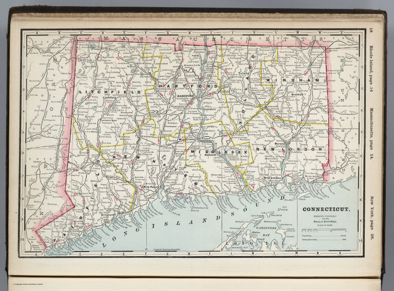
Author
Cram, George Franklin
Full Title
Connecticut. Engraved Expressly for the Standard World Atlas.
List No
4727.007
Note
Prime meridians Washington D.C. and Greenwich. Relief shown by hachures. With printed color.
Author
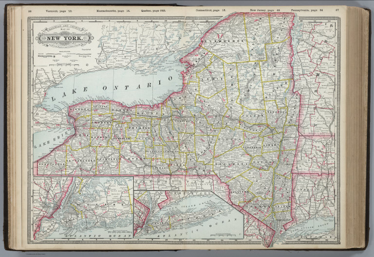
Cram, George Franklin
Full Title
Railroad and County Map of New York. Geo. F. Cram. Engraver and Publisher, Chicago. (insets) (Long Island; New York City and Vicinity).
List No
4727.008
Note
Prime meridians Washington D.C. and Greenwich. Relief shown by hachures. With printed color.
Author
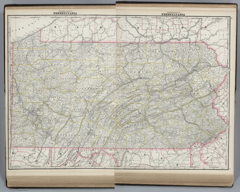
Cram, George Franklin
Full Title
Western Half of Pennsylvania.
List No
4727.009
Note
Prime meridians Washington D.C. and Greenwich. Relief shown by hachures. With printed color.
Author
Cram, George Franklin
Full Title
Eastern Half of Pennsylvania.
List No
4727.010
Note
Prime meridians Washington D.C. and Greenwich. Relief shown by hachures. With printed color.
Author
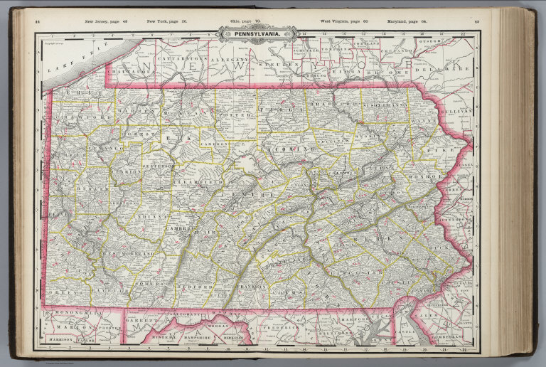
Cram, George Franklin
Full Title
(Composite of) Pennsylvania.
List No
4727.011
Note
Prime meridians Washington D.C. and Greenwich. Relief shown by hachures. With printed color.
Author
Cram, George Franklin
Full Title
Pennsylvania.
List No
4727.012
Note
Prime meridians Washington D.C. and Greenwich. Relief shown by hachures. With printed color.
Author
Cram, George Franklin
Full Title
Railroad and County Map of New Jersey. Geo. F. Cram. Engraver and Publisher, Chicago. (inset) Environs of Hudson County.
List No
4727.013
Note
Prime meridians Washington D.C. and Greenwich. Relief shown by hachures. With printed color.
Author
Cram, George Franklin
Full Title
Western Half of Virginia and West Virginia, Engraved Expressly for the Standard Atlas of the World.
List No
4727.014
Note
Prime meridians Washington D.C. and Greenwich. Relief shown by hachures. With printed color.
Author
Cram, George Franklin
Full Title
Eastern Half of Virginia and West Virginia, Engraved Expressly for the Standard Atlas of the World.
List No
4727.015
Note
Prime meridians Washington D.C. and Greenwich. Relief shown by hachures. With printed color.
Author
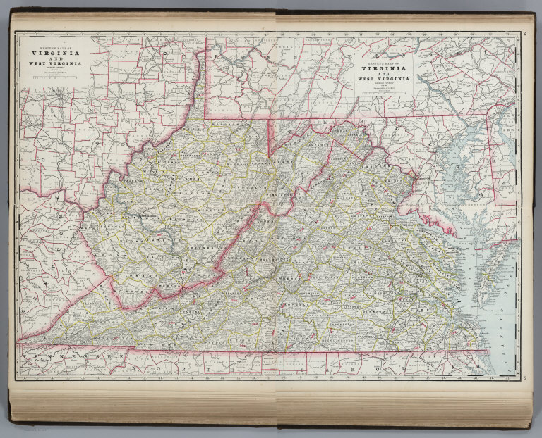
Cram, George Franklin
Full Title
(Composite of) Virginia and West Virginia.
List No
4727.016
Note
Prime meridians Washington D.C. and Greenwich. Relief shown by hachures. With printed color.
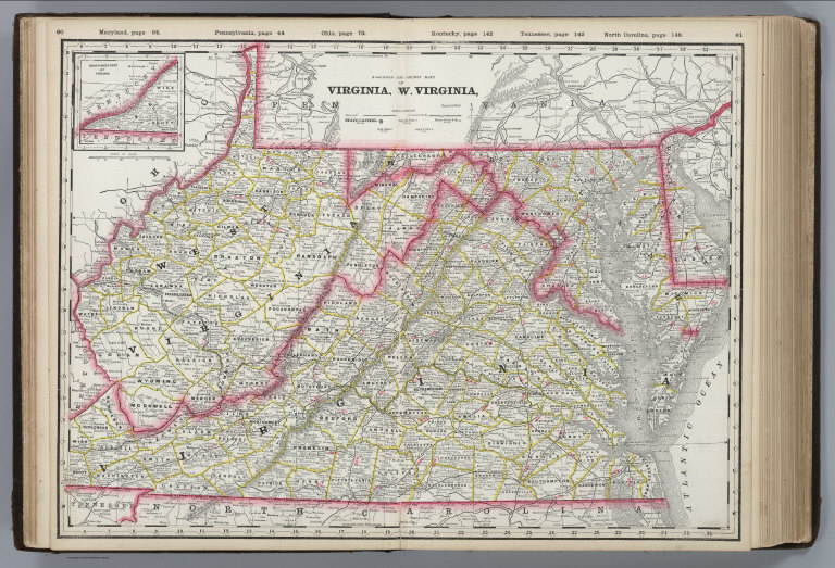
Author
Cram, George Franklin
Full Title
A Railroad and County Map, Virginia, W. Virginia.
List No
4727.017
Note
Prime meridians Washington D.C. and Greenwich. Relief shown by hachures. With printed color.
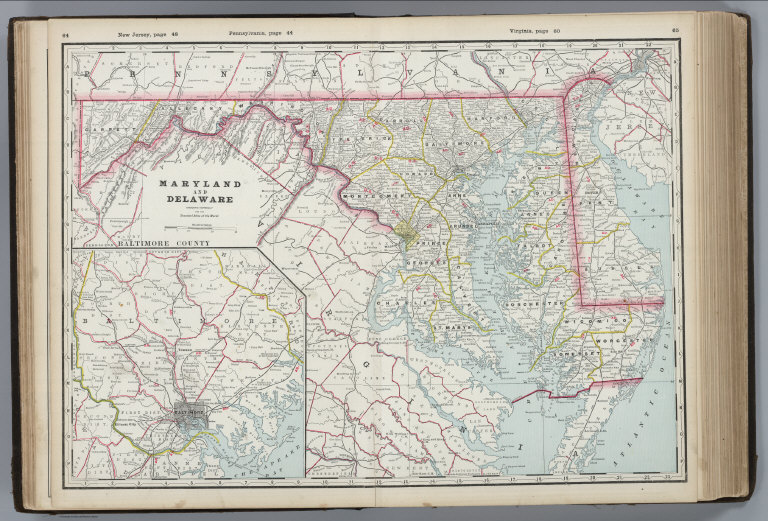
Author
Cram, George Franklin
Full Title
Maryland and Delaware, Engraved Exclusively for the Standard Atlas of the World. (inset) Baltimore County.
List No
4727.018
Note
Prime meridians Washington D.C. and Greenwich. Relief shown by hachures. With printed color.
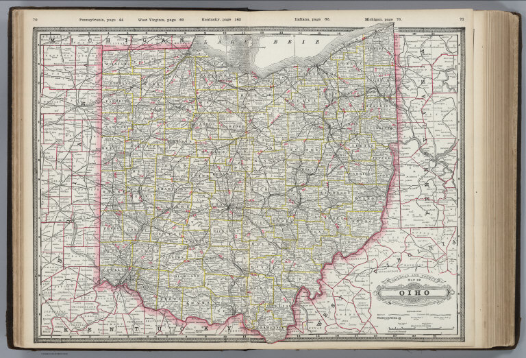
Author
Cram, George Franklin
Full Title
Railroad and County Map of Oiho [sic] (Ohio). Geo. F. Cram. Engraver and Publisher, Chicago.
List No
4727.019
Note
Prime meridians Washington D.C. and Greenwich. Relief shown by hachures. With printed color.
Author
Cram, George Franklin
Full Title
Michigan. (insets) (continuation of main map); Isle Royale.
List No
4727.020
Note
Prime meridians Washington D.C. and Greenwich. Relief shown by hachures. With printed color.
Author
Cram, George Franklin
Full Title
Indiana.
List No
4727.021
Note
Prime meridians Washington D.C. and Greenwich. Relief shown by hachures. With printed color.
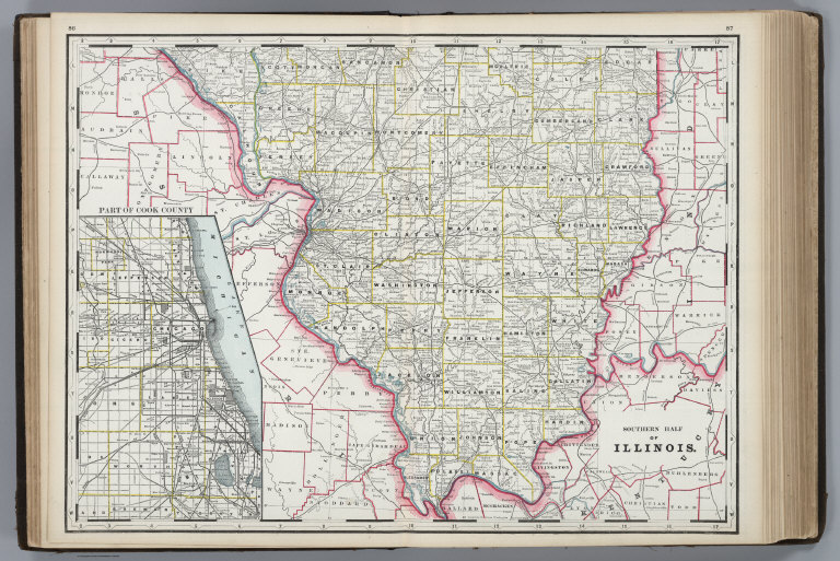
Author
Cram, George Franklin
Full Title
Southern Half of Illinois. (inset) Part of Cook County.
List No
4727.022
Note
Prime meridians Washington D.C. and Greenwich. Relief shown by hachures. With printed color.
Author
Cram, George Franklin
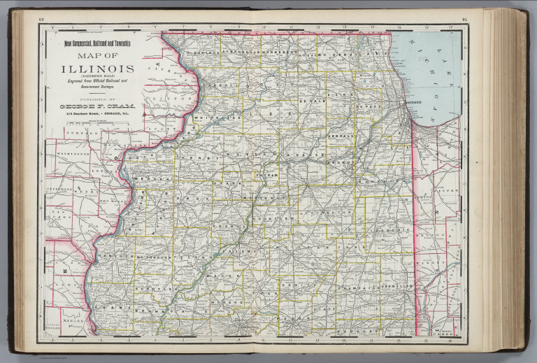
Full Title
New Commercial, Railroad and Township, Map of Illinois (Northern Half), Engraved from Official Railroad and Government Surveys. Published by George F. Cram, 415 Dearborn Street - Chicago, Ill.
List No
4727.023
Note
Prime meridians Washington D.C. and Greenwich. Relief shown by hachures. With printed color.
Author
Cram, George Franklin
Full Title
Railroad and County Map of Illinois. Geo. F. Cram, Engraver and Publisher, Chicago. (inset) Part of Cook County.
List No
4727.024
Note
Prime meridians Washington D.C. and Greenwich. Relief shown by hachures. With printed color.
Author
Cram, George Franklin
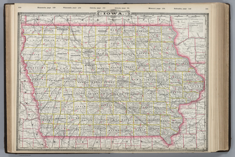
Full Title
Iowa.
List No
4727.025
Note
Prime meridians Washington D.C. and Greenwich. Relief shown by hachures. With printed color.
Author
Cram, George Franklin
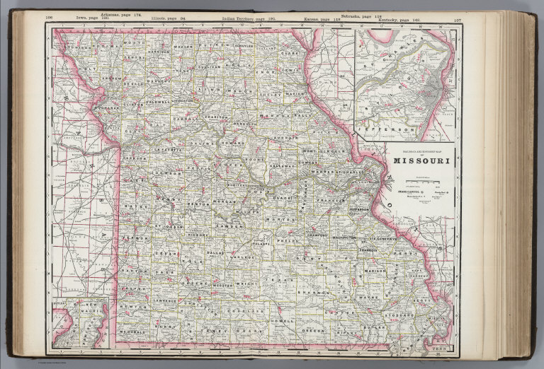
Full Title
Railroad and Township Map of Missouri. (inset) (St. Louis and Vicinity).
List No
4727.026
Note
Prime meridians Washington D.C. and Greenwich. Relief shown by hachures. With printed color.
Author
Cram, George Franklin
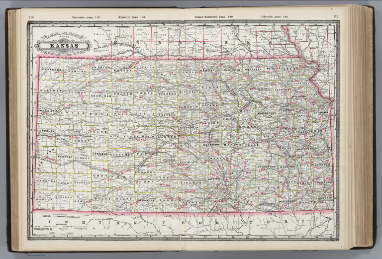
Full Title
Railroad and County Map of Kansas. Geo. F. Cram. Engraver and Publisher, Chicago.
List No
4727.027
Note
Prime meridians Washington D.C. and Greenwich. Relief shown by hachures. With printed color.
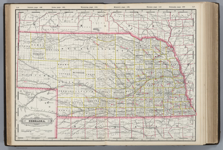
Author
Cram, George Franklin
Full Title
Railroad and County Map of Nebraska. Geo. F. Cram. Engraver and Publisher, Chicago.
List No
4727.028
Note
Prime meridians Washington D.C. and Greenwich. Relief shown by hachures. With printed color.
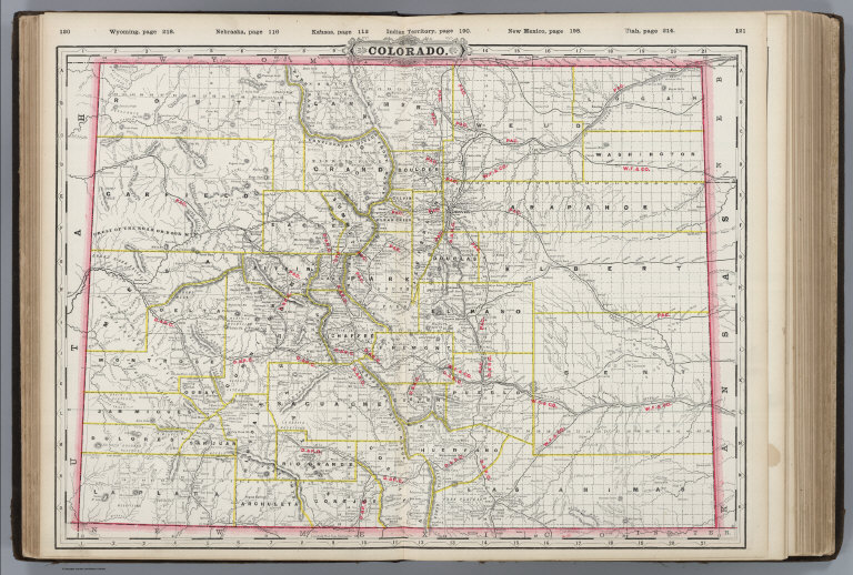
Author
Cram, George Franklin
Full Title
Colorado.
List No
4727.029
Note
Prime meridians Washington D.C. and Greenwich. Relief shown by hachures. With printed color.
Author
Cram, George Franklin
Full Title
Wisconsin.
List No
4727.030
Note
Prime meridians Washington D.C. and Greenwich. Relief shown by hachures. With printed color.
Author
Cram, George Franklin
Full Title
Minnesota. (inset) (continuation of main map).
List No
4727.031
Note
Prime meridians Washington D.C. and Greenwich. Relief shown by hachures. With printed color.
Author
Cram, George Franklin
Full Title
Railroad and County Map of Dakota. Geo. F. Cram. Engraver and Publisher, Chicago.
List No
4727.032
Note
Prime meridians Washington D.C. and Greenwich. Relief shown by hachures. With printed color.
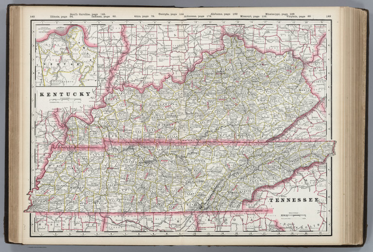
Author
Cram, George Franklin
Full Title
Kentucky. Tennessee.
List No
4727.033
Note
Prime meridians Washington D.C. and Greenwich. Relief shown by hachures. With printed color.
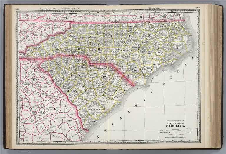
Author
Cram, George Franklin
Full Title
New Railroad and County Map of North & South Carolina.
List No
4727.034
Note
Prime meridians Washington D.C. and Greenwich. Relief shown by hachures. With printed color.
Author
Cram, George Franklin
Full Title
Railroad and County Map of Georgia. Geo. F. Cram. Engraver and Publisher, Chicago.
List No
4727.035
Note
Prime meridians Washington D.C. and Greenwich. Relief shown by hachures. With printed color.
Author
Cram, George Franklin
Full Title
Railroad and County Map of Florida. Geo. F. Cram. Engraver and Publisher, Chicago. (inset) North-Western Portion of Florida (continuation of main map).
List No
4727.036
Note
Prime meridians Washington D.C. and Greenwich. Relief shown by hachures. With printed color.
Author
Cram, George Franklin
Full Title
Railroad and County Map of Alabama. Geo. F. Cram. Engraver and Publisher, Chicago.
List No
4727.037
Note
Prime meridians Washington D.C. and Greenwich. Relief shown by hachures. With printed color.
|