|
REFINE
Browse All : Railroad from 1887
1-46 of 46
Author
[Atchison and Nebraska Railroad, Chicago, Burlington, and Quincy Railroad]
Full Title
Composite: County maps of Richardson county in Nebraska, and Doniphan, Brown, and Atchison counties in Kansas.
List No
10287.026
Note
A set of 24 hand-drawn and colored maps showing the route of the proposed Atchison and Nebraska Railroad in northern Kansas and southern Nebraska, just west of the Missouri River. Many annotations in pencil list the land owners of parcels the proposed railroad line goes through and the cost per acre under sale contract. There are also notes on sheet 8 on the Condemnation of land for an owner who will not sell. The line appears to have been built approximately according to the drawings although in some areas the route was changed - this is based on comparing the routes shown on the 1887 county maps. The set of maps provides a detailed record of how land was secured for the railroads and how the lines were surveyed. View in Google Earth https://rumsey3.s3.amazonaws.com/Atchison_and_Nebraska_Railroad_1872.kmz
Author
[Ministere des Travaux Publics, Cheysson, Émile]
Full Title
Carte Figurative des Recettes Brutes Kilometriques des Chemins de Fer Francais en 1884. (Gross earnings of the French railroads in 1884.)
List No
12517.009
Note
Graph type: flow.
Author
[Ministere des Travaux Publics, Cheysson, Émile]
Full Title
Carte Figurative des Benefices Nets Kilometriques des Chemins de Fer Francais en 1884. (Net prices of the French railroads in 1884.)
List No
12517.010
Note
Graph type: flow.
Author
[Ministere des Travaux Publics, Cheysson, Émile]
Full Title
Mouvement des Viyageurs Transportes sur les --Chemins de Fer en 1884. (Gross earnings of the French railroad stations in 1884.)
List No
12517.011
Note
Graph type: divided proportional circle.
Author
[Ministere des Travaux Publics, Cheysson, Émile]
Full Title
Carte Figurative des Voyageurs Transportes Sur les Chemins de Fer en 1884. (Number of travelers transported on the French railroads in 1884.)
List No
12517.012
Author
[Ministere des Travaux Publics, Cheysson, Émile]
Full Title
Carte Figurative des Expeditions de Voyageurs et de Marchandises effectuees en 1884... Chemins de Fer Francais. (Movement of the travelers and the goods in the principal stations of the French railroads in 1884.)
List No
12517.013
Note
Graph type: mosaic.
Author
[Ministere des Travaux Publics, Cheysson, Émile]
Full Title
Carte Figurative du Tonnage des Chemins de Fer Francais en 1884. (Tonnage of the French railroads in 1884.)
List No
12517.014
Note
Graph type: flow.
Author
[Ministere des Travaux Publics, Cheysson, Émile]
Full Title
Carte Figurative des Recettes Brutes Kilometriques des Chemins des Fer Francais en 1885. (Gross earnings of the French railroads in 1885.)
List No
12518.009
Note
Graph type: flow.
Author
[Ministere des Travaux Publics, Cheysson, Émile]
Full Title
Carte Figurative des Benefices Nets Kilometriques des Chemins des Fer Francais en 1885. (Net earnings of the French railroads in 1885.)
List No
12518.010
Note
Graph type: flow.
Author
[Ministere des Travaux Publics, Cheysson, Émile]
Full Title
Mouvement des Voyageurs Transportes Sur les Chemins de Fer en 1885. (Number of travellers transferred via the railroads French in 1885.)
List No
12518.011
Note
Graph type: flow.
Author
[Ministere des Travaux Publics, Cheysson, Émile]
Full Title
Carte Figurative du Tonnage des Chemins de Fer Francais en 1885. (Tonnage of the French railroads in 1885.)
List No
12518.012
Note
Graph type: flow.
Author
[Ministere des Travaux Publics, Cheysson, Émile]
Full Title
(Statistical Diagram) I. Effectif du Personnel Total de 1866 a 1885. (Personnel of the large railroad companies between 1866 and 1885: Total manpower.)
List No
12518.027
Note
Graph type: bar.
Author
Stanford, Edward, 1827-1904
Full Title
11. A railway map of the British Isles. London: Edward Stanford, 55 Charing Cross, S.W. Stanford's Geographical Establishment.
List No
14053.069
Note
Railway map of the British Isles, in colored lithograph. Shows towns, railways, with frequency of train travel, as well as water routes, with distances. Includes a legend, as well as a bar scale. With inset: Shetland Islands. 59 x 50 cm, on sheet 71 x 55 cm. In Vol. II.
Author
[Everts & Co., L.H. Everts & Co.]
Full Title
Building of Neosho Investment Company ... (with) Public school building, 1st Ward ... (with) Missouri Pacific stock yards ... (with) Union Depot, Missouri Pacific round house, yards, &c. (all) Chetopa, Kansas. (L.H. Everts & Co., publishers, Philadelphia, 1887)
List No
2818.131
Note
Four lithographed views.
Author
[Rand McNally and Company, Watson, Gaylord]
Full Title
(Covers to) New Railroad, County and Township Map Of New York Showing Every Railroad Station and Post Office in the State. Address, Gaylord Watson, 278 Pearl Street, New York. 1887. Copyright, 1887, by Rand, McNally & Co., Map Publishers, Chicago. (with 3 inset maps).
List No
3228.001
Note
Issued with the Legislative Manual. Insets of New York City, Buffalo, and Long Island. This map appears in parts in the 1882 Rand McNally Indexed Atlas of the World. It is mysterious why Gaylord Watson's name appears on this map. He had other collaborations with Rand McNally (see his New Indexed Family Atlas of the World, 1884) which may relate to this. Map is folded into red textured cloth covers 17x11 stamped with "Map Of The State Of New-York Accompanying The Legislative Manual 1887. Weed, Parsons & Co." in gilt. Printed outline color by county and township.
Author
[Rand McNally and Company, Watson, Gaylord]
Full Title
New Railroad, County and Township Map Of New York Showing Every Railroad Station and Post Office in the State. Address, Gaylord Watson, 278 Pearl Street, New York. 1887. Copyright, 1887, by Rand, McNally & Co., Map Publishers, Chicago. (with 3 inset maps).
List No
3228.002
Note
Issued with the Legislative Manual. Insets of New York City, Buffalo, and Long Island. This map appears in parts in the 1882 Rand McNally Indexed Atlas of the World. It is mysterious why Gaylord Watson's name appears on this map. He had other collaborations with Rand McNally (see his New Indexed Family Atlas of the World, 1884) which may relate to this. Map is folded into red textured cloth covers 17x11 stamped with "Map Of The State Of New-York Accompanying The Legislative Manual 1887. Weed, Parsons & Co." in gilt. Printed outline color by county and township. Relief shown by hachures.
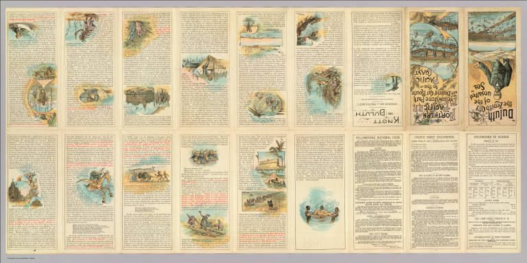
Author
Northern Pacific Railroad Company
Full Title
(Covers to) The Northern Pacific R.R. The Yellowstone Park and dining car route to the Pacific Coast. Poole Bros. Printers and Engravers, Chicago.
List No
3570A
Author
Northern Pacific Railroad Company
Full Title
(Text Page to) The Northern Pacific R.R. The Yellowstone Park and dining car route to the Pacific Coast. Poole Bros. Printers and Engravers, Chicago.
List No
3570B
Note
(18) p. on 1 sheet. Text, ill. Includes speech "Knott on Duluth" by J. Proctor Knott of Kentucky, delivered in the House of Representatives Feb., 1871.
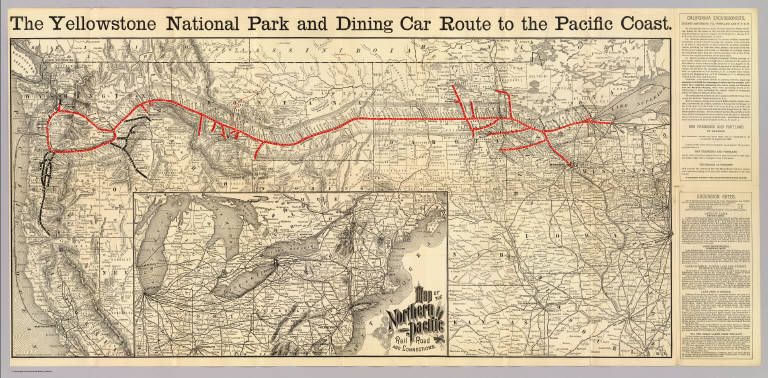
Author
Northern Pacific Railroad Company
Full Title
The Yellowstone Park and dining car route to the Pacific Coast. Rand, McNally & Co., Engr's, Chicago. (inset) Map of the Northern Pacific Rail Road and connections.
List No
3570.001
Note
Relief shown by hachures. Map shows railroad route in red, otherwise is printed without color. Generally covers area from Fresno, Calif. and Cairo, Ill. north, and from Chicago west, excluding Colorado, Utah and most of Nevada and Nebraska. Inset covers northeastern U.S.
Author
Cram, George Franklin
Full Title
(Covers to) Railroad And County Map Of Alabama. Engraved for Grant's Business Atlas.
List No
4112.001
Note
The date is estimated from the exact match of this map to the map in Cram's Standard American Atlas of 1887. Cram also produced these maps for Grant's Business Atlas - here he did not bother to change the title. Catalogue of Cram's two major atlases of the period in the back. In blue paper covers 15x10 with the view of a steam engine and train, and titled "Cram's Township And Rail Road Map Of Alabama. Published By George F. Cram, 262 & 264 Wabash Ave., Chicago." in black. With 22 page Index to State Map of Alabama. Printed color. Prime meridians are Greenwich and Washington D.C.
Author
Cram, George Franklin
Full Title
Railroad And County Map Of Alabama. Engraved for Grant's Business Atlas.
List No
4112.002
Note
The date is estimated from the exact match of this map to the map in Cram's Standard American Atlas of 1887. Cram also produced these maps for Grant's Business Atlas - here he did not bother to change the title. Catalogue of Cram's two major atlases of the period in the back. In blue paper covers 15x10 with the view of a steam engine and train, and titled "Cram's Township And Rail Road Map Of Alabama. Published By George F. Cram, 262 & 264 Wabash Ave., Chicago." in black. With 22 page Index to State Map of Alabama. Printed color. Prime meridians are Greenwich and Washington D.C.
Author
Cram, George Franklin
Full Title
(Covers to) Railroad And County Map Of Texas. (inset map) Indian Ter. Geo. F. Cram, Engraver and Publisher, Chicago.
List No
4750.001
Note
With Cram's 29 page index. The same map appeared in Cram's Standard American Atlas of 1887. Printed color. Folded into blue paper covers 15x9.5 with "Cram's Township And Rail Road Map Of Texas. Published By George F. Cram, 262 & 264 Wabash Ave., Chicago." printed in black.
Author
Cram, George Franklin
Full Title
Railroad And County Map Of Texas. (inset map) Indian Ter. Geo. F. Cram, Engraver and Publisher, Chicago.
List No
4750.002
Note
With Cram's 29 page index. The same map appeared in Cram's Standard American Atlas of 1887. Printed color. Folded into blue paper covers 15x9.5 with "Cram's Township And Rail Road Map Of Texas. Published By George F. Cram, 262 & 264 Wabash Ave., Chicago." printed in black. Relief shown by hachures. Prime meridians are Greenwich and Washington D.C.
Author
St. Paul, Minneapolis & Manitoba Railway Company.
Full Title
(Covers to) St. Paul, Minneapolis & Manitoba Ry. Red River Valley Line through the park region ... 2 +87. Matthews, Northrup & Co., Art-Printing Works, Buffalo, N.Y.
List No
5244A
Author
St. Paul, Minneapolis & Manitoba Railway Company.
Full Title
(Text Page to) St. Paul, Minneapolis & Manitoba Ry. Red River Valley Line through the park region ... 2 +87. Matthews, Northrup & Co., Art-Printing Works, Buffalo, N.Y.
List No
5244B
Note
16 p. on 1 sheet. Color. Includes timetables and text on lands for sale.
Author
St. Paul, Minneapolis & Manitoba Railway Company.
Full Title
St. Paul, Minneapolis & Manitoba Ry. Manitoba-Pacific route. Matthews, Northrup & Co., art-printing works, Buffalo, N.Y. (1887)
List No
5244.001
Note
Relief shown by hachures. Shows townships, etc. Inset maps: Map showing the location of Osakis, Alexandria, & Ashby. Summer resorts on the line of the St. Paul Minneapolis & Manitoba Ry. -- (Canadian Pacific, St. Paul, Minneapolis & Manitoba Ry. and other routes from Winnepeg to the Pacific coast)
Author
Central Vermont Railroad Company
Full Title
(Covers to) Central Vermont and Grand Trunk Line. Summer edition, 1887. Cheapest route to the West ... American Bank Note Co. N.Y.
List No
5259A
Author
Central Vermont Railroad Company
Full Title
(Text Page to) Central Vermont and Grand Trunk Line. Summer edition, 1887. Cheapest route to the West ... American Bank Note Co. N.Y.
List No
5259B
Note
Includes timetables, fare tables, small map of downtown Chicago, and text.
Author
Central Vermont Railroad Company
Full Title
The Central Vermont Railroad and its connections. Eng'd by American Bank Note Co., New York.
List No
5259.002
Note
Relief shown by hachures. Western U.S. shown in reduced scale inset map. Some parts of the South are omitted. Prime meridians: Greenwich and Washington.
Author
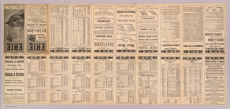
New York, Lake Erie, and Western Railroad Company
Full Title
(Covers to) Erie Ry. New York, Lake Erie and Western R.R. August, 1887. Map and time tables inside ... Rand, McNally & Co., Printers and Engravers, Chicago.
List No
5260A
Author
New York, Lake Erie, and Western Railroad Company
Full Title
(Text Page to) Erie Ry. New York, Lake Erie and Western R.R. August, 1887. Map and time tables inside ... Rand, McNally & Co., Printers and Engravers, Chicago.
List No
5260B
Note
(20) p. on 1 sheet. Includes text, timetables, text.
Author
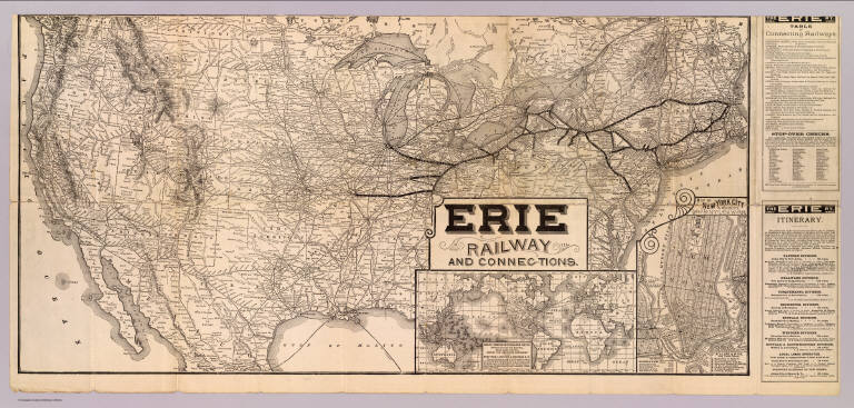
New York, Lake Erie, and Western Railroad Company
Full Title
Erie Railway and connections. (inset) Map of New York City & vicinity issued by N.Y.L.E. & W. R.R. (inset) Great American Overland Route between Europe and Australia, China, Japan and India, across the American continent via the New York, Lake Erie & Western R.R. ...
List No
5260.001
Note
Relief shown by hachures. Includes tables of connecting railways.
Author
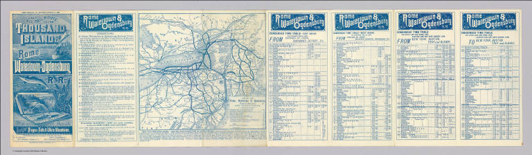
Rome, Watertown & Ogdensburg Railroad Company
Full Title
(Covers to) Only all rail route to the Thousand Islands, Rome, Watertown and Ogdensburg R.R. The only scenic route. Short Line Niagara Falls & White Mountains. Liberty Ptg. Co., N.Y. Time table no. 26 - revised October 24, 1887 ... Oliphant's Print, Oswego, N.Y.
List No
5265A
Author
Rome, Watertown & Ogdensburg Railroad Company
Full Title
Map of the Rome, Watertown & Ogdensburg Railroad and connections. Revised October 24, 1887 ...
List No
5265.001
Note
Relief shown by hachures. Includes self wrapper, text and timetables. On sheet 72 x 20.
Author
Rome, Watertown & Ogdensburg Railroad Company
Full Title
(Text Page to) Only all rail route to the Thousand Islands, Rome, Watertown and Ogdensburg R.R. The only scenic route. Short Line Niagara Falls & White Mountains. Liberty Ptg. Co., N.Y. Time table no. 26 - revised October 24, 1887 ... Oliphant's Print, Oswego, N.Y.
List No
5265B
Note
Timetables.
Author
Montreal and Boston Air Line
Full Title
(Covers to) Montreal and Boston Air Line. The picturesque White Mountain Route between New England and Canada via Lake Memphremagog. Summer time-tables, 1887 ... Russell & Richardson Sc. First edition ... R.A. Supply Co., Boston.
List No
5267A
Author
Montreal and Boston Air Line
Full Title
(Text Page to) Montreal and Boston Air Line. The picturesque White Mountain Route between New England and Canada via Lake Memphremagog. Summer time-tables, 1887 ... Russell & Richardson Sc. First edition ... R.A. Supply Co., Boston.
List No
5267B
Note
(16) p. on 1 sheet. Timetables, text, self wrappers.
Author
Montreal and Boston Air Line
Full Title
Map of the Montreal and Boston Air Line, Passumpsic, and South Eastern Railroads, and connections. Rand, Avery & Co., Eng's., Boston ... (inset) Map of Lake Memphremagog, Newport, Vt. Junction of Passumpsic and So. Eastern R.Rs.
List No
5267.001
Note
Relief shown by hachures. Covers area from Washington, D.C. and Buffalo to Quebec and Cape Cod. Illustrations: Balance Rock -- Mt. Orford -- Skinner's Cave -- Owl's Head -- Round Island -- Mt. Elephantis (all at Lake Memphrmagog) -- Boston & Lowell Railroad Station.
Author
[New York, Lake Erie, and Western Railroad Company, New York, Pennsylvania and Ohio Railroad Company]
Full Title
(Covers to) New York, Lake Erie and Western R.R. Co. New York, Pennsylvania & Ohio R.R. .. Poole Bros., Printers and Engravers, Chicago. Time table in effect August 21st. 1887.
List No
5269A
Author
[New York, Lake Erie, and Western Railroad Company, New York, Pennsylvania and Ohio Railroad Company]
Full Title
(Text Page to) New York, Lake Erie and Western R.R. Co. New York, Pennsylvania & Ohio R.R. .. Poole Bros., Printers and Engravers, Chicago. Time table in effect August 21st. 1887.
List No
5269B
Note
Time tables, text, self wrappers.
Author
[New York, Lake Erie, and Western Railroad Company, New York, Pennsylvania and Ohio Railroad Company]
Full Title
Map of the New York, Pennsylvania and Ohio Railroad and connections. Poole Bros., Map Engravers, Chicago. (1887)
List No
5269.001
Note
Relief shown by hachures. Covers most of U.S. east from Denver.
Author
Wabash Railway Company
Full Title
(Covers to) The Wabash Railway official time tables and other information concerning the Wabash Railway. Corrected to Sept. 20, 1887 ... Rand McNally & Co., Printers and Engravers, Chicago.
List No
5270A
Author
Wabash Railway Company
Full Title
Map of the Wabash Railway. John McNulta, receiver. Miles operated 956. Rand, McNally & Co., Engr's, Chicago.
List No
5270.001
Note
Covers area from Omaha to Buffalo. Shows connecting railroads.
Author
Pittsburgh & Western Railway Company
Full Title
(Covers to) The Pittsburgh & Western Railway Company. Lessee Pittsburgh, Cleveland & Toledo and Pittsburgh, Painesville and Fairport railroads. Time table of passenger trains, in effect August 1st, 1887. Central Standard Time ... Johnston, Print.
List No
5278A
Author
Pittsburgh & Western Railway Company
Full Title
Map of the Pittsburg & Western Railroad and connections. Rand, McNally & Co., Engr's, Chicago.
List No
5278.001
Note
Covers area from St. Louis to Buffalo. On sheet 21 x 35 cm. with self wrapper, passenger information and timetables.
Author
Pittsburgh & Western Railway Company
Full Title
(Text Page to) The Pittsburgh & Western Railway Company. Lessee Pittsburgh, Cleveland & Toledo and Pittsburgh, Painesville and Fairport railroads. Time table of passenger trains, in effect August 1st, 1887. Central Standard Time ... Johnston, Print.
List No
5278B
Note
(4) p. timetables on 1 sheet.
1-46 of 46
|