|
Author
Cram, George Franklin, 1841-1928
Full Title
Railroad and county map of Ohio. Geo. F. Cram, engraver and publisher, Chicago. 1882.
List No
14250.007
Note
Map of Ohio, showing railroads (both finished and unfinished), county boundaries, cities and towns, post offices, drainage and coastline. Political boundary lines in color. Includes a legend and a bar scale. With index numbers along the perimeter, and decorative border. 43 x 57 cm, on sheet 45 x 58.
Author
Cram, George Franklin, 1841-1928
Full Title
Michigan. Geo. F. Cram, engraver and publisher, 262 and 264 Wabash Avenue, Chicago, Ill. 1882.
List No
14250.011
Note
Map of Michigan, showing railroads (both finished and unfinished), county boundaries, cities and towns, drainage and coastline, as well as ports and water distances across Lake Michigan. Political boundary lines in color. Includes a legend and a bar scale. Each of the Great Lakes pictured - Michigan, Superior and Huron - lists metrics for greatest length, breadth, depth, and height above sea. With index numbers along the perimeter, and decorative border. Also, with two inset maps: Isle Royale -- Dominion of Canada. 55 x 40 cm, on sheet 58 x 45 cm.
Author
Cram, George Franklin, 1841-1928
Full Title
Indiana. Geo. F. Cram, engraver and publisher, 262 and 264 Wabash Avenue, Chicago, Ill. 1882.
List No
14250.014
Note
Map of Michigan, showing railroads (both finished and unfinished), county boundaries, cities and towns, drainage and coastline. Political boundary lines in color. With index numbers along the perimeter, and decorative border. 55 x 40 cm, on sheet 58 x 45 cm.
Author
Cram, George Franklin, 1841-1928
Full Title
Illinois. Geo. F. Cram, engraver and publisher, 262 and 264 Wabash Avenue, Chicago, Ill. 1882.
List No
14250.018
Note
Map of Illinois, showing railroads (both finished and unfinished), county boundaries, cities and towns, drainage and coastline. Political boundary lines in color. With index numbers along the perimeter, and decorative border. Also, with inset map: [Chicago and vicinity]. 55 x 40 cm, on sheet 58 x 45 cm.
Author
Cram, George Franklin, 1841-1928
Full Title
New railroad and county map of Iowa : Showing latest government surveys. Published by Geo. F. Cram, 262-264 Wabash Ave. Chicago. 1882.
List No
14250.020
Note
Map of Iowa, showing railroads (both proposed and existing), county boundaries, cities and towns, and drainage. Political boundary lines in color. Includes a legend and a bar scale. With index numbers along the perimeter, and decorative border. 37 x 50 cm, on sheet 45 x 58.
Author
Cram, George Franklin, 1841-1928
Full Title
New railroad and county map of Missouri : Showing latest government surveys. Published by Geo. F. Cram, 262-264 Wabash Ave. Chicago. 1882.
List No
14250.022
Note
Map of Missouri, showing railroads (both proposed and existing), county boundaries, cities and towns, and drainage. Political boundary lines in color. Includes a legend and a bar scale. With index numbers along the perimeter, and decorative border. Also, with two inset maps: The south-eastern extension of Missouri -- [St. Louis and vicinity]. 42 x 52 cm, on sheet 45 x 58.
Author
Cram, George Franklin, 1841-1928
Full Title
Cram's railroad and township map of Kansas. Published by Geo. F. Cram, proprietor of the Western Map Depot. 262-264 Wabash Ave. Chicago Ills. 1882.
List No
14250.024
Note
Map of Kansas, showing railroads, county boundaries, cities and towns, and drainage. Political boundary lines in color. Features territories of indigenous peoples, such as the Cheyenne, Osage and Cherokee. Includes a bar scale and a scale statement: Scale 19 miles to an inch. With index numbers along the perimeter, and decorative border. 39 x 53 cm, on sheet 45 x 58.
Author
Cram, George Franklin, 1841-1928
Full Title
Cram's railroad and township map of Nebraska. Published by Geo. F. Cram. 262-264 Wabash Ave. Chicago, Ills. 1882.
List No
14250.026
Note
Map of Nebraska, showing railroads, county boundaries, cities and towns, and drainage. Political boundary lines in color. Features territories of indigenous peoples, such as the Cheyenne and Sioux. Includes a bar scale and a scale statement: Scale 19 miles to an inch. With index numbers along the perimeter, and decorative border. 40 x 52 cm, on sheet 45 x 58.
Author
Cram, George Franklin, 1841-1928
Full Title
Cram's railroad and township map of Colorado. Published by Geo. F. Cram. 262-264 Wabash Ave. Chicago, Ills. 1882.
List No
14250.028
Note
Map of Colorado, showing railroads, county boundaries, cities and towns, and drainage. Political boundary lines in color. With index numbers along the perimeter, and decorative border. Also, with hand-drawn annotations tracing routes of travel, both along railroads and across landscapes where no official transit appears. 40 x 52 cm, on sheet 45 x 58.
Author
Cram, George Franklin, 1841-1928
Full Title
Wisconsin. Geo. F. Cram, engraver and publisher, 262 and 264 Wabash Avenue, Chicago, Ill. 1882.
List No
14250.032
Note
Map of Wisconsin, showing railroads (both finished and unfinished), county boundaries, cities and towns, post offices, drainage and coastline. Political boundary lines in color. Both of the Great Lakes pictured - Superior and Michigan - list metrics for greatest length, breadth, depth, and height above sea. Includes a legend and a bar scale. With index numbers along the perimeter, and decorative border. 55 x 40 cm, on sheet 58 x 45 cm.
Author
Cram, George Franklin, 1841-1928
Full Title
Minnesota. Geo. F. Cram, engraver and publisher, 262 and 264 Wabash Avenue, Chicago Ill.
List No
14250.034
Note
Map of Minnesota, showing railroads (both finished and unfinished), county boundaries, cities and towns, post offices, drainage and coastline. Political boundary lines in color. Features Indian reservations. Lake Superior lists metrics for greatest length, breadth, depth, and height above sea. Includes a legend and a bar scale. With index numbers along the perimeter, and decorative border. Also, with inset map: [Cook]. 55 x 40 cm, on sheet 58 x 45 cm.
Author
Cram, George Franklin, 1841-1928
Full Title
Railroad and county map of Dakota & Manitoba. Geo. F. Cram, engraver and publisher, Chicago.
List No
14250.036
Note
Map of the Dakotas and Manitoba (Canada), showing railroads (both finished and unfinished), county boundaries, cities and towns, post offices and drainage. Political boundary lines in color. Includes a legend. With index numbers along the perimeter, and decorative border. Also, with hand-drawn annotations tracing routes of travel across landscapes where no official transit appears. 55 x 40 cm, on sheet 58 x 45 cm.
Author
Cram, George Franklin, 1841-1928
Full Title
Railroad and county map of Kentucky and Tennessee. Geo. F. Cram, engraver and publisher, Chicago.
List No
14250.040
Note
Map of Kentucky and Tennessee, showing railroads (both finished and unfinished), county boundaries, cities and towns, and drainage. Political boundary lines in color. Includes a legend. With index numbers along the perimeter, and decorative border. Also, with hand-drawn annotations tracing routes of travel across landscapes where no official transit appears. 39 x 55 cm, on sheet 45 x 58 cm.
Author
Cram, George Franklin, 1841-1928
Full Title
Cram's railroad and county map of Georgia. Published by Geo. F. Cram, 262-264, Wabash, Ave. Chicago, Ills. 1882
List No
14250.042
Note
Map of Georgia, showing railroads, county boundaries, cities and towns, drainage and coastline. Political boundary lines in color. Includes a bar scale and a scale statement: Scale 19 miles to an inch. With index numbers along the perimeter, and decorative border. 47 x 37 cm, on sheet 58 x 45 cm.
Author
Cram, George Franklin, 1841-1928
Full Title
Cram's railroad and township map of Alabama. Published by Geo. F. Cram, proprietor of the Western Map Depot. 262-264, Wabash, Ave. Chicago Ills. 1882
List No
14250.044
Note
Map of Alabama, showing railroads, county boundaries, cities and towns, drainage and coastline. Political boundary lines in color. Includes a bar scale and a scale statement: Scale 19 miles to an inch. With index numbers along the perimeter, and decorative border. 51 x 31 cm, on sheet 58 x 45 cm.
Author
Cram, George Franklin, 1841-1928
Full Title
Cram's railroad and township map of Mississippi. Published by Geo. F. Cram, proprietor of the Western Map Depot. 262-264, Wabash, Ave. Chicago Ills. 1882
List No
14250.046
Note
Map of Mississippi, showing railroads, county boundaries, cities and towns, drainage and coastline. Political boundary lines in color. Includes a bar scale and a scale statement: Scale 19 miles to an inch. With index numbers along the perimeter, and decorative border. Also, with 53 x 28 cm, on sheet 58 x 45 cm.
Author
Cram, George Franklin, 1841-1928
Full Title
Cram's railroad and township map of Louisiana. Published by Geo. F. Cram, proprietor of the Western Map Depot. 262-264, Wabash, Ave. Chicago Ills. 1882
List No
14250.048
Note
Map of Louisiana, showing railroads, county boundaries, cities and towns, drainage and coastline. Political boundary lines in color. Includes a bar scale and a scale statement: Scale 18 miles to an inch. With index numbers along the perimeter, and decorative border. 51 x 42 cm, on sheet 58 x 45 cm.
Author
Cram, George Franklin, 1841-1928
Full Title
Cram's railroad and township map of Arkansas. Published by Geo. F. Cram, proprietor of the Western Map Depot. 262-264, Wabash, Ave. Chicago Ills. 1882
List No
14250.050
Note
Map of Arkansas, showing railroads, county boundaries, cities and towns, and drainage. Political boundary lines in color. Includes a bar scale and a scale statement: Scale 19 miles to an inch. With index numbers along the perimeter, and decorative border. 38 x 46 cm, on sheet 45 x 58 cm.
Author
Cram, George Franklin, 1841-1928
Full Title
Railroad and county map of Texas. Geo. F. Cram, engraver and publisher, Chicago.
List No
14250.053
Note
Map of Texas, showing railroads (both finished and unfinished), county boundaries, cities and towns, post offices, drainage and coastline. Political boundary lines in color. Includes a legend and a bar scale. With index numbers along the perimeter, and decorative border. Also, with an inset map: [Northern Texas]. 41 x 55 cm, on sheet 45 x 58 cm.
Author
Cram, George Franklin, 1841-1928
Full Title
Cram's railroad and township map of Indian, Ter. Published by Geo. F. Cram, proprietor of the Western Map Depot. 262-264. Wabash, Ave. Chicago Ills. 1882
List No
14250.054
Note
Map of Indian Territory, showing railroads, county boundaries, cities and towns, post offices, and drainage. Political boundary lines in color. Features territories of indigenous peoples, such as the Kiowa, Comanche, Chickasaw, Choctaw and Apache. With index numbers along the perimeter, and decorative border. 35 x 50 cm, on sheet 45 x 58 cm.
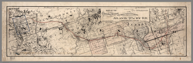
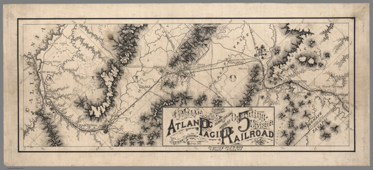
Author
Atlantic & Pacific Railroad
Full Title
Map of the First Operating Division of the Western Division, Atlantic & Pacific R.R., From Albuquerque to Coolidge. Drawing No. J2-902. Lewis Kingman, Chief Engineer.
List No
6929.001
Note
A set of six hand-drawn maps on semi-transparent waxed linen with some color. Some areas are colored on the verso to highlight the areas in a muted style. We think that some type of backlighting was planned to be used to create a photolithographic plate from which printing would be done. No evidence was found that it was ever printed. These sheets were deaccessioned from the Santa Fe Railroad collection in the 1980s. Lewis Kingman did the route survey from Albuquerque to Needles. Relief shown by hachures. This sheet has colored lines on the verso to add color to the various areas depicted on the recto.
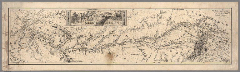
Author
Atlantic & Pacific Railroad
Full Title
Map of the 2nd Operating Division of the Western Division, Atlantic & Pacific R.R., From Coolidge to Winslow. Drawing No. J-2-902.
List No
6929.002
Note
Lavishly illustrated title block. No drawing on verso. A set of six hand-drawn maps on semi-transparent waxed linen with some color. Some areas are colored on the verso to highlight the areas in a muted style. We think that some type of backlighting was planned to be used to create a photolithographic plate from which printing would be done. No evidence was found that it was ever printed. These sheets were deaccessioned from the Santa Fe Railroad collection in the 1980s. Lewis Kingman did the route survey from Albuquerque to Needles. Relief shown by hachures.
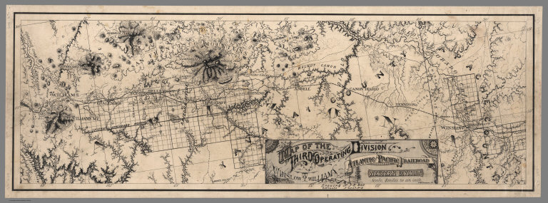
Author
Atlantic & Pacific Railroad
Full Title
Map of the Third Operating Division of the Western Division, Atlantic & Pacific R.R., From From Winslow to Williams. Drawing No. J-2-902.
List No
6929.003
Note
Drawing on verso behind title block. A set of six hand-drawn maps on semi-transparent waxed linen with some color. Some areas are colored on the verso to highlight the areas in a muted style. We think that some type of backlighting was planned to be used to create a photolithographic plate from which printing would be done. No evidence was found that it was ever printed. These sheets were deaccessioned from the Santa Fe Railroad collection in the 1980s. Lewis Kingman did the route survey from Albuquerque to Needles. Relief shown by hachures.
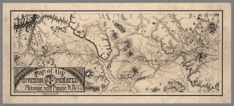
Author
Atlantic & Pacific Railroad
Full Title
Map of the 4th Operating Division of the Western Division, Atlantic & Pacific R.R., From Williams to Peach Springs. Drawing No. J-2-902.
List No
6929.004
Note
Drawing on verso behind title block. A set of six hand-drawn maps on semi-transparent waxed linen with some color. Some areas are colored on the verso to highlight the areas in a muted style. We think that some type of backlighting was planned to be used to create a photolithographic plate from which printing would be done. No evidence was found that it was ever printed. These sheets were deaccessioned from the Santa Fe Railroad collection in the 1980s. Lewis Kingman did the route survey from Albuquerque to Needles. Relief shown by hachures.
Author
Atlantic & Pacific Railroad
Full Title
Map of the 5th Operating Division of the Western Division, Atlantic & Pacific R.R., From Peach Springs to Needles. W.A. Drake, Acting Chief Engineer. Drawing No. J-2-902.
List No
6929.005
Note
No drawing on verso. A set of six hand-drawn maps on semi-transparent waxed linen with some color. Some areas are colored on the verso to highlight the areas in a muted style. We think that some type of backlighting was planned to be used to create a photolithographic plate from which printing would be done. No evidence was found that it was ever printed. These sheets were deaccessioned from the Santa Fe Railroad collection in the 1980s. Lewis Kingman did the route survey from Albuquerque to Needles. Relief shown by hachures.
Author
Atlantic & Pacific Railroad
Full Title
Map of the 6th Operating Division of the Western Division, Atlantic & Pacific R.R., From Needles to Mojave. Saml. M. Rowe, Resident Engineer. Drawing No. J-2-902.
List No
6929.006
Note
No drawing on verso. A set of six hand-drawn maps on semi-transparent waxed linen with some color. Some areas are colored on the verso to highlight the areas in a muted style. We think that some type of backlighting was planned to be used to create a photolithographic plate from which printing would be done. No evidence was found that it was ever printed. These sheets were deaccessioned from the Santa Fe Railroad collection in the 1980s. Lewis Kingman did the route survey from Albuquerque to Needles. Relief shown by hachures.
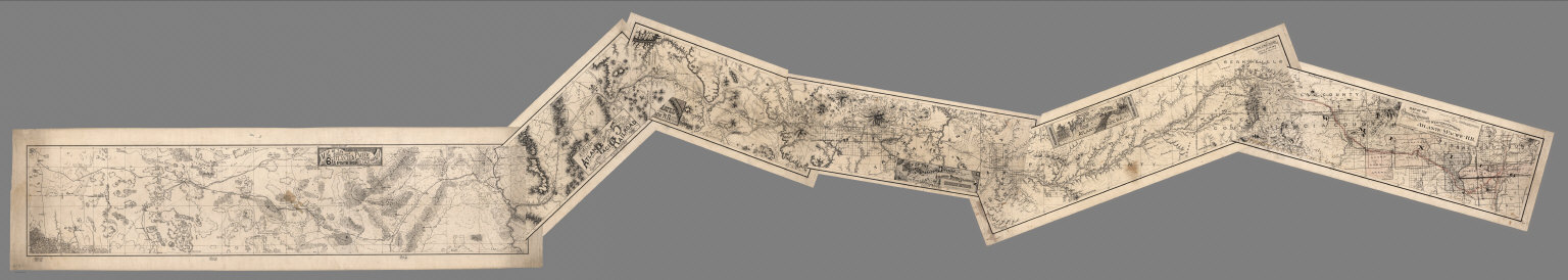
Author
Atlantic & Pacific Railroad
Full Title
(Composite of) Maps of the First through Sixth Operating Divisions of the Western Division, Atlantic & Pacific Railroad, Albuquerque, New Mexico, to Mojave (Mohave), California.
List No
6929.007
Note
Composite of all six maps joined together end to end. This is a set of six hand-drawn maps on semi-transparent waxed linen with some color. Some areas are colored on the verso to highlight the areas in a muted style. We think that some type of backlighting was planned to be used to create a photolithographic plate from which printing would be done. No evidence was found that it was ever printed. These sheets were deaccessioned from the Santa Fe Railroad collection in the 1980s. Lewis Kingman did the route survey from Albuquerque to Needles. Relief shown by hachures.
Author
(Canada) Ministry of Public Works
Full Title
Dominion Of Canada Telegraph & Signal Service. Map No.1 (Eastern-Section). Sir Hector L. Langevin, K.C.M.G.-C.B., Minister of Public Works. F.N. Gisborne, M.I.T.E.E.-F.R.S.C., &c., Supt. T. & S. Service. 1883. Projected By F.N. Gisborne. Drawn By Gust. Smith.
List No
0118.000
Author
[Ministere des Travaux Publics, Cheysson, Émile]
Full Title
Carte Formative du Tonnage des Chemins de Fer Francais en 1880. (Tonnage of the French railroads in 1880.)
List No
12513.010
Author
[Ministere des Travaux Publics, Cheysson, Émile]
Full Title
Carte Figurative des Expeditions de Voyageurs et de Marchandises Effectuees en 1880. (Expeditions of Travelers and Goods Made in 1880.)
List No
12513.014
Author
[Ministere des Travaux Publics, Cheysson, Émile]
Full Title
Mouvement Martime des Principaux Ports de L'Algerie et Tonnage de ses Chemins de Fer en 1880. (Main Ports of Algeria and Tonnage of its Railways in 1880.)
List No
12513.018
Author
[Ministere des Travaux Publics, Cheysson, Émile]
Full Title
(Statistical Diagram) Chemins de Fer D'Interet General en 1879. (Railways Of General Interest In 1879.)
List No
12513.021
Author
[Ministere des Travaux Publics, Cheysson, Émile]
Full Title
(Statistical Diagram) Chemins de Fer Francais D'Interet General en 1879. I. Recettes Brutes et Depenses D'Exploitation par Kilometre. (French Railways Of General Interest in 1879. I. Gross Revenue and Operating Expenses per Kilometer.)
List No
12513.022
Author
[Ministere des Travaux Publics, Cheysson, Émile]
Full Title
(Statistical Diagram) Chemins de Fer Francais D'Interet General en 1879. II. Resultats D'Exploitation et Emploi de Produit Net Total par les Six Grandes Compagnies. (French Railways Of General Interest in 1879. II. Operating Results and Employment of Total Net Revenue by the Six Large Companies.)
List No
12513.023
Author
[Ministere des Travaux Publics, Cheysson, Émile]
Full Title
(Statistical Diagram) Chemins de Fer Francais D'Interet General. Grandes Compagnies. III. Garantie D'Interets. (French Railways Of General Interest. Big Companies. III. Interest Guarantee.)
List No
12513.024
Author
[Ministere des Travaux Publics, Cheysson, Émile]
Full Title
Carte Figurative des Benefices Nets Kilometriques des Chemins de Fer Francais en 1880. (Net Kilometric Benefits of the French Railways in 1880.)
List No
12513.026
Author
[Ministere des Travaux Publics, Cheysson, Émile]
Full Title
Carte Figurative des Recettes des Stations des Chemins de Fer Francais en 1880. (Revenue from the Stations of the French Railways in 1880.)
List No
12513.027
Author
[Ministere des Travaux Publics, Cheysson, Émile]
Full Title
(Statistical Diagram) Diagramme des Recettes et depenses D'Exploitation ... de 1876 a 1881. (Diagram of Income and Operating Expenses ... from 1876 to 1881.)
List No
12513.028
Author
Blackie, W.G.
Full Title
Central Europe Showing the Principal Railways and the Political Boundaries at the Close of the Franco-German War.
List No
1589.032
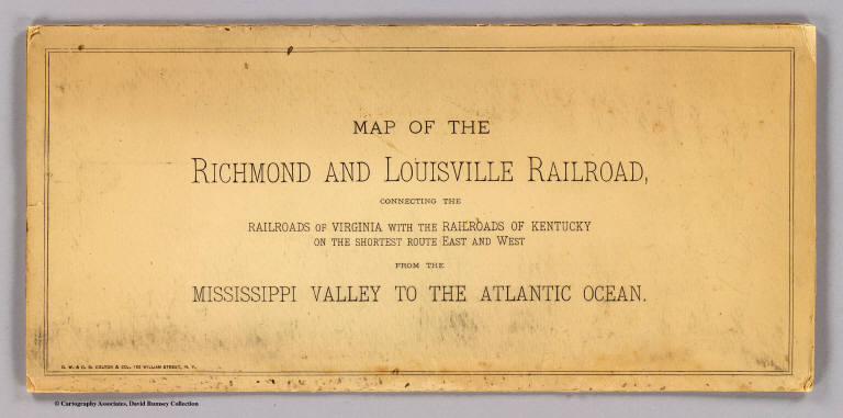
Author
G.W. & C.B. Colton & Co.
Full Title
(Covers to) Map of the Richmond and Louisville R.R. connecting the railroads of Virginia with the railroads of Kentucky on the shortest route east and west from the Mississippi Valley to the Atlantic Ocean. Engraved, printed and manufactured by G.W. & C.B. Colton & Co. No. 182 William St. New York. Entered ... 1882 by G.W. & C.B. Colton & Co. ... at Washington.
List No
1702A
Note
Heavy beige paper covers printed with the title: Map of the Richmond and Louisville Railroad, connecting the railroads of Virginia with the railroads of Kentucky on the shortest route east and west from the Mississippi Valley to the Atlantic Ocean.
Author
G.W. & C.B. Colton & Co.
Full Title
Map of the Richmond and Louisville R.R. connecting the railroads of Virginia with the railroads of Kentucky on the shortest route east and west from the Mississippi Valley to the Atlantic Ocean. Engraved, printed and manufactured by G.W. & C.B. Colton & Co. No. 182 William St. New York. Entered ... 1882 by G.W. & C.B. Colton & Co. ... at Washington.
List No
1702.001
Note
Relief shown by hachures. Outline color by state with railroads colored in red and blue.
Author
Rand McNally and Company
Full Title
(Covers to) Rand, McNally & Co's. general map of the Republic of Mexico constructed from the best authorities showing completed & proposed railways, steamship routes and telegraphic communications. Chicago, U.S. 1882. Rand, McNally & Co., Map Publisher and Engravers, Chicago, Ill. Copyrighted, 1882 by Rand, McNally & Co., Chicago, Ill.
List No
3347A
Note
Very large hand colored map with detailed engraving. This does not look like the "normal" Rand McNally map - it is probably a separately made map that they acquired the rights to. This copy was sold in England by Edward Stanford and has his label on the case. Map is in four sheets, each dissected into 21 sections. With outline color by state, topography shown in brown, and railways and shipping routes in red. Sheets have marbled end papers with labels reading "North East", "North West", "South East" and "South West"; all fold into a brown cloth slip case 22.5x14.5 with a label reading "Mexico. London: Edward Stanford, Wholesale & Retail Mapseller, &c. 55, Charing Cross. Agent by Appointment ..." Relief shown by shading. Prime meridians: Washington and Greenwich.
Author
Rand McNally and Company
Full Title
Rand, McNally & Co's. general map of the Republic of Mexico constructed from the best authorities showing completed & proposed railways, steamship routes and telegraphic communications. Chicago, U.S. 1882. Rand, McNally & Co., Map Publisher and Engravers, Chicago, Ill. Copyrighted, 1882 by Rand, McNally & Co., Chicago, Ill.
List No
3347.001
Note
Very large hand colored map with detailed engraving. This does not look like the "normal" Rand McNally map - it is probably a separately made map that they acquired the rights to. This copy was sold in England by Edward Stanford and has his label on the case. Map is in four sheets, each dissected into 21 sections. With outline color by state, topography shown in brown, and railways and shipping routes in red. Sheets have marbled end papers with labels reading "North East", "North West", "South East" and "South West"; all fold into a brown cloth slip case 22.5x14.5 with a label reading "Mexico. London: Edward Stanford, Wholesale & Retail Mapseller, &c. 55, Charing Cross. Agent by Appointment ..." Relief shown by shading. Prime meridians: Washington and Greenwich.
Author
Cram, George Franklin
Full Title
New Rail Road and County Map of New York.
List No
4558.026
Author
Cram, George Franklin
Full Title
New Rail Road and County Map of Pennsylvania, New Jersey, Delaware & Maryland.
List No
4558.027
Author
Cram, George Franklin
Full Title
New Rail Road and County Map of Virginia & West Virginia.E
List No
4558.028
Author
Cram, George Franklin
Full Title
New Rail Road and County Map of North Carolina.
List No
4558.029
Author
Cram, George Franklin
Full Title
New Rail Road and County Map of Arkansas, Louisiana, & Mississippi.
List No
4558.034
Author
Cram, George Franklin
Full Title
New Rail Road and County Map of Indian Territory and Northern Part of Texas.
List No
4558.036
Author
Cram, George Franklin
Full Title
New Rail Road and County Map of Southern Part of Texas.
List No
4558.037
|