|
REFINE
Browse All : Railroad from 1868
1-15 of 15
Author
Colton, G.W. & C.B.
Full Title
(Covers to) Colton's Railroad & Township Map Of The State Of New York, With Parts of the Adjoining States & Canada. Published by G.W. And C.B. Colton & Co. No. 172 William St. New York 1868. Entered ... 1852, by J.H. Colton ... N. York. Drawn by Geo. W. Colton.
List No
2135.001
Note
Small changes when compared to our 1855 edition (see #179), just a few railroads added. Still drawn by G.W. Colton, but Atwood's name removed as "Sculpt". Map is folded into dark brown cloth covers 14.5x9.5 with "Colton's Township Map Of The State Of New-York G.W. & C.B. Colton & Co." in gilt. Full color by township. Prime meridians are Greenwich and Washington D.C. Relief shown by hachures.
Author
Colton, G.W. & C.B.
Full Title
Colton's Railroad & Township Map Of The State Of New York, With Parts of the Adjoining States & Canada. Published by G.W. And C.B. Colton & Co. No. 172 William St. New York 1868. Entered ... 1852, by J.H. Colton ... N. York. Drawn by Geo. W. Colton.
List No
2135.002
Note
Small changes when compared to our 1855 edition (see #179), just a few railroads added. Still drawn by G.W. Colton, but Atwood's name removed as "Sculpt". Map is folded into dark brown cloth covers 14.5x9.5 with "Colton's Township Map Of The State Of New-York G.W. & C.B. Colton & Co." in gilt. Full color by township. Prime meridians are Greenwich and Washington D.C. Relief shown by hachures.
Author
Lloyd, J. T.
Full Title
Lloyd's Topographical Railway Map of North America or the United States Continent in 1900...(On verso: Lloyd's New Map of the United States The Canadas and New Brunswick From The Latest Surveys Showing Every Railroad & Station Finished to June 1862... 1866).
List No
2859.001
Note
Two sided wall map -see 1866 copy. Similar to the 1866 edition, but some changes - adds inset of South America, the Pacific Railway route has been changed to go north of Salt Lake, some of the ads on the steamship routes have been deleted, and on the verso in addition to the U.S. map there are insets of major cities and their rail lines.
Author
Lloyd, J. T.
Full Title
Lloyd's New Map of the United States The Canadas and New Brunswick From The Latest Surveys Showing Every Railroad & Station Finished to June 1862... 1866. (On verso: ) Lloyd's Topographical Railway Map of North America or the United States Continent in 1900....
List No
2859.002
Note
Two sided wall map -see 1866 copy. On this side, in addition to the U.S. map, there are insets of major cities and their rail lines. Similar to the 1866 edition, but some changes - on the verso North America map, adds inset of South America, the Pacific Railway route has been changed to go north of Salt Lake, some of the ads on the steamship routes have been deleted.
Author
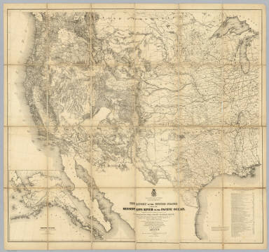
[Freyhold, Edward, Warren, Gouverneur Kemble, 1830-1882]
Full Title
Territory Of The United States From The Mississippi River To The Pacific Ocean; Originally prepared to accompany the Reports of the Explorations For A Pacific Railroad Route ... Compiled from authorized explorations and other reliable data by Lieut. G.K. Warren, Top'l. Eng'rs. In the Office of Pacific R.R. Surveys, War Dept. under the direction of Bvt. Maj. W.H. Emory, Top'l. Eng'rs. in 1854. Capt. A.A. Humphreys, Top'l. Eng'rs. in 1854-58. Recompiled and redrawn under the direction of the Chief of Corps of Engineers By Edward Freyhold 1865-66-67-68. Head Quarters Corp Of Engineers, War Department. Engraved & printed by Julius Bien, N.Y. (inset) Territory Of Alaska Ceded By Russia To The United States 1868.
List No
2919.000
Note
Alaska inset; 59 "authorities"; Streeter copy. Wheat: "one of the great American maps, and one profoundly influential." The final revision of the original Warren map of 1857; largely redrawn, in substance, and style of hachuring. An earlier state of the same imprint is described in Streeter 3080. See Wheeler vol 1 reference. In 1879 Freyhold issued another larger version of this map (Wheat 1295) (see our copy). Without color. Dissected into 24 sections and mounted on linen. Folds into a new burgundy cloth folding case 30x22 with original spine label reading "Freyhold - Map Of Explorations For Pacific R.R. - Recompiled 1865-68."
Author
Cram, George Franklin
Full Title
(Covers to) New Rail Road And Township Map Of Iowa Engraved From Official Draughts of each County. Published By George F. Cram, Dealer In: Maps, Charts, Lithographic Pictures, Steel Engravings, Photographs &c. &c. 134 Lake St. Chicago, Ill. 1868. Entered ... 1868 by George F. Cram ... Illinois. Chas. Shober & Co. Lith. Chicago, Ill.
List No
3022.001
Note
1st edition, 1st year of operation for Cram's business. Everything about this map is different from Cram's later productions: it is his first year of operation, at 134 Lake Street, and the style of the cover, the map and the cartouche all have an "early" and unsophisticated look. Charles Shober is listed as Lithographer. Cram also produced the Guide Map to Chicago in 1868 (see our copy). Surviving pre fire maps by Cram are rare. Karrow shows 1869 maps for Missouri, Missouri and Kansas together, and Illinois, (all engraved by Pfeiffer, not Shober), but he shows no 1868 maps other than this Iowa and the Chicago maps. So this may be Cram's first state pocket map. It is copyright 1868. There is a view of a steam engine in the cartouche; this does not appear in later Cram maps. A 10 page index lists principal towns and counties, and gives a brief history of the state. Full color. Map is folded into stamped dark green cloth covers 14x9 with "New Township Map Of Iowa" in gilt.
Author
Cram, George Franklin
Full Title
(Title Page to) New Rail Road And Township Map Of Iowa Engraved From Official Draughts of each County. Published By George F. Cram, Dealer In: Maps, Charts, Lithographic Pictures, Steel Engravings, Photographs &c. &c. 134 Lake St. Chicago, Ill. 1868. Entered ... 1868 by George F. Cram ... Illinois. Chas. Shober & Co. Lith. Chicago, Ill.
List No
3022.002
Note
1st edition, 1st year of operation for Cram's business. Everything about this map is different from Cram's later productions: it is his first year of operation, at 134 Lake Street, and the style of the cover, the map and the cartouche all have an "early" and unsophisticated look. Charles Shober is listed as Lithographer. Cram also produced the Guide Map to Chicago in 1868 (see our copy). Surviving pre fire maps by Cram are rare. Karrow shows 1869 maps for Missouri, Missouri and Kansas together, and Illinois, (all engraved by Pfeiffer, not Shober), but he shows no 1868 maps other than this Iowa and the Chicago maps. So this may be Cram's first state pocket map. It is copyright 1868. There is a view of a steam engine in the cartouche; this does not appear in later Cram maps. A 10 page index lists principal towns and counties, and gives a brief history of the state. Full color. Map is folded into stamped dark green cloth covers 14x9 with "New Township Map Of Iowa" in gilt.
Author
Cram, George Franklin
Full Title
New Rail Road And Township Map Of Iowa Engraved From Official Draughts of each County. Published By George F. Cram, Dealer In: Maps, Charts, Lithographic Pictures, Steel Engravings, Photographs &c. &c. 134 Lake St. Chicago, Ill. 1868. Entered ... 1868 by George F. Cram ... Illinois. Chas. Shober & Co. Lith. Chicago, Ill.
List No
3022.003
Note
1st edition, 1st year of operation for Cram's business. Everything about this map is different from Cram's later productions: it is his first year of operation, at 134 Lake Street, and the style of the cover, the map and the cartouche all have an "early" and unsophisticated look. Charles Shober is listed as Lithographer. Cram also produced the Guide Map to Chicago in 1868 (see our copy). Surviving pre fire maps by Cram are rare. Karrow shows 1869 maps for Missouri, Missouri and Kansas together, and Illinois, (all engraved by Pfeiffer, not Shober), but he shows no 1868 maps other than this Iowa and the Chicago maps. So this may be Cram's first state pocket map. It is copyright 1868. There is a view of a steam engine in the cartouche; this does not appear in later Cram maps. A 10 page index lists principal towns and counties, and gives a brief history of the state. Full color. Map is folded into stamped dark green cloth covers 14x9 with "New Township Map Of Iowa" in gilt.
Author
[Frey, A.C., Nell, Louis]
Full Title
Topographical Railroad & County Map Of The States Of California And Nevada Compiled from the latest explorations and other official information by L. Nell, N.Y. Published by A.C. Frey & Co 204 Fulton St. New York. General Agents for California A. Roman & Co. 417 & 419 Montgomery St. San Francisco. Ferd. Mayer & Co. Lithographers, 96 Fulton St. N.Y. Entered ... 1868 by Frey & Nell ... New York. (inset) Map of the City of San Francisco, California. (inset) Map Of The Great National Pacific Railroads.
List No
3440.000
Note
Wheat writes several pages about this map, being impressed with its up to date cartography. Williamson's proposed route through the Owyhee to the Idaho mines is shown, as well as much current detail in central Nevada and all of California. The influence of Williamson's 1866 "Map of Parts of California, Nevada, Oregon and Idaho Territory" (both the published and the ms version) is obvious. A wheel shows the "Difference of time between S. Francisco and other important Cities." This may be Louis Nell's first commercial map, before his extensive work for the Wheeler Survey in the 1870's and his Colorado maps of the 1880's. The railroad map shows the Union Pacific completed to Cheyenne and the Central Pacific to the Nevada border. This is both a beautiful map and an excellent depiction of California and Nevada just before the completion of the railroad. Wheat mentions that the towns of the Humboldt valley are sprinkled with names that disappear in a few years with the coming of the railroad. Full color by county.
Author
[Walling, Henry Francis, 1825-1888, Lloyd, H.H.]
Full Title
Railroad map of Ohio, Indiana and Illinois. Published for Henry S. Stebbins By H.H. Lloyd & Co. New York. (to accompany) Atlas Of The State Of Ohio. 1868.
List No
4726.036
Note
Hand colored map. Shows counties, roads, railroads, canals, cities and towns for Ohio, Indiana and Illinois. Relief shown by hachures.
Author
Freyhold, Edward; Warren, Gouverneur Kemble, 1830-1882
Full Title
(NW Sheet to) Territory Of The United States From The Mississippi River To The Pacific Ocean; Originally prepared to accompany the Reports of the Explorations For A Pacific Railroad Route ... Compiled from authorized explorations and other reliable data by Lieut. G.K. Warren, Top'l. Eng'rs. In the Office of Pacific R.R. Surveys, War Dept. under the direction of Bvt. Maj. W.H. Emory, Top'l. Eng'rs. in 1854. Capt. A.A. Humphreys, Top'l. Eng'rs. in 1854-58. Recompiled and redrawn under the direction of the Chief of Corps of Engineers By Edward Freyhold 1865-66-67-68. Head Quarters Corp Of Engineers, War Department. Engraved & printed by Julius Bien, N.Y. (inset) Territory Of Alaska Ceded By Russia To The United States 1868.
List No
6756.001
Note
Alaska inset; 59 "authorities"; This copy consists of four separate sheets, unjoined. Similar to our case map copy 2919.000 (the Streeter copy). Wheat: "one of the great American maps, and one profoundly influential." The final revision of the original Warren map of 1857; largely redrawn, in substance, and style of hachuring. An earlier state of the same imprint is described in Streeter 3080. See Wheeler vol 1 reference. In 1879 Freyhold issued another larger version of this map (Wheat 1295) (see our copy). Without color.
Author
Freyhold, Edward; Warren, Gouverneur Kemble, 1830-1882
Full Title
(NE Sheet to) Territory Of The United States From The Mississippi River To The Pacific Ocean; Originally prepared to accompany the Reports of the Explorations For A Pacific Railroad Route ... Compiled from authorized explorations and other reliable data by Lieut. G.K. Warren, Top'l. Eng'rs. In the Office of Pacific R.R. Surveys, War Dept. under the direction of Bvt. Maj. W.H. Emory, Top'l. Eng'rs. in 1854. Capt. A.A. Humphreys, Top'l. Eng'rs. in 1854-58. Recompiled and redrawn under the direction of the Chief of Corps of Engineers By Edward Freyhold 1865-66-67-68. Head Quarters Corp Of Engineers, War Department. Engraved & printed by Julius Bien, N.Y. (inset) Territory Of Alaska Ceded By Russia To The United States 1868.
List No
6756.002
Note
Alaska inset; 59 "authorities"; This copy consists of four separate sheets, unjoined. Similar to our case map copy 2919.000 (the Streeter copy). Wheat: "one of the great American maps, and one profoundly influential." The final revision of the original Warren map of 1857; largely redrawn, in substance, and style of hachuring. An earlier state of the same imprint is described in Streeter 3080. See Wheeler vol 1 reference. In 1879 Freyhold issued another larger version of this map (Wheat 1295) (see our copy). Without color.
Author
Freyhold, Edward; Warren, Gouverneur Kemble, 1830-1882
Full Title
(SE Sheet to) Territory Of The United States From The Mississippi River To The Pacific Ocean; Originally prepared to accompany the Reports of the Explorations For A Pacific Railroad Route ... Compiled from authorized explorations and other reliable data by Lieut. G.K. Warren, Top'l. Eng'rs. In the Office of Pacific R.R. Surveys, War Dept. under the direction of Bvt. Maj. W.H. Emory, Top'l. Eng'rs. in 1854. Capt. A.A. Humphreys, Top'l. Eng'rs. in 1854-58. Recompiled and redrawn under the direction of the Chief of Corps of Engineers By Edward Freyhold 1865-66-67-68. Head Quarters Corp Of Engineers, War Department. Engraved & printed by Julius Bien, N.Y. (inset) Territory Of Alaska Ceded By Russia To The United States 1868.
List No
6756.003
Note
Alaska inset; 59 "authorities"; This copy consists of four separate sheets, unjoined. Similar to our case map copy 2919.000 (the Streeter copy). Wheat: "one of the great American maps, and one profoundly influential." The final revision of the original Warren map of 1857; largely redrawn, in substance, and style of hachuring. An earlier state of the same imprint is described in Streeter 3080. See Wheeler vol 1 reference. In 1879 Freyhold issued another larger version of this map (Wheat 1295) (see our copy). Without color.
Author
Freyhold, Edward; Warren, Gouverneur Kemble, 1830-1882
Full Title
(SW Sheet to) Territory Of The United States From The Mississippi River To The Pacific Ocean; Originally prepared to accompany the Reports of the Explorations For A Pacific Railroad Route ... Compiled from authorized explorations and other reliable data by Lieut. G.K. Warren, Top'l. Eng'rs. In the Office of Pacific R.R. Surveys, War Dept. under the direction of Bvt. Maj. W.H. Emory, Top'l. Eng'rs. in 1854. Capt. A.A. Humphreys, Top'l. Eng'rs. in 1854-58. Recompiled and redrawn under the direction of the Chief of Corps of Engineers By Edward Freyhold 1865-66-67-68. Head Quarters Corp Of Engineers, War Department. Engraved & printed by Julius Bien, N.Y. (inset) Territory Of Alaska Ceded By Russia To The United States 1868.
List No
6756.004
Note
Alaska inset; 59 "authorities"; This copy consists of four separate sheets, unjoined. Similar to our case map copy 2919.000 (the Streeter copy). Wheat: "one of the great American maps, and one profoundly influential." The final revision of the original Warren map of 1857; largely redrawn, in substance, and style of hachuring. An earlier state of the same imprint is described in Streeter 3080. See Wheeler vol 1 reference. In 1879 Freyhold issued another larger version of this map (Wheat 1295) (see our copy). Without color.
Author
Freyhold, Edward; Warren, Gouverneur Kemble, 1830-1882
Full Title
(Composite of) Territory Of The United States From The Mississippi River To The Pacific Ocean; Originally prepared to accompany the Reports of the Explorations For A Pacific Railroad Route ... Compiled from authorized explorations and other reliable data by Lieut. G.K. Warren, Top'l. Eng'rs. In the Office of Pacific R.R. Surveys, War Dept. under the direction of Bvt. Maj. W.H. Emory, Top'l. Eng'rs. in 1854. Capt. A.A. Humphreys, Top'l. Eng'rs. in 1854-58. Recompiled and redrawn under the direction of the Chief of Corps of Engineers By Edward Freyhold 1865-66-67-68. Head Quarters Corp Of Engineers, War Department. Engraved & printed by Julius Bien, N.Y. (inset) Territory Of Alaska Ceded By Russia To The United States 1868.
List No
6756.005
Note
Composite of all four sheets. Alaska inset; 59 "authorities"; This copy consists of four separate sheets, unjoined. Similar to our case map copy 2919.000 (the Streeter copy). Wheat: "one of the great American maps, and one profoundly influential." The final revision of the original Warren map of 1857; largely redrawn, in substance, and style of hachuring. An earlier state of the same imprint is described in Streeter 3080. See Wheeler vol 1 reference. In 1879 Freyhold issued another larger version of this map (Wheat 1295) (see our copy). Without color.
1-15 of 15
|