|
REFINE
Browse All : Railroad from 1845
1-6 of 6
Author
Anderson, P.
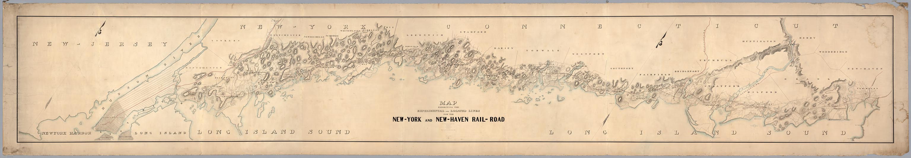
Full Title
Map Exhibiting The Experimental and Located Lines for the New-York and New-Haven Rail-Road ... Projected and Drawn by P. Anderson Civil Engr. Scale 1 to 20,000. Feb. 1845.
List No
6902.000
Note
This is probably the prepublication manuscript drawing for the final printed version of this map that was issued in the same year - see our 4218.000. It is twice the size and scale of the final printed version, and is beautifully hand drawn and colored. It is amazing that a map this large has survived outside of an institutional library for so long. Apparently it was kept in a family for several generations. It was leant to us by its current owner so that we could scan it and put it online. From our notes to the printed version: Greatly detailed strip map over twenty feet long showing the surveyed routes of the New York and New Haven Railroad. The line was opened in 1849. The map is unique for a railroad map in its huge size, large scale, elegance of drawing, and variety of information shown (houses, trails, rivers, turnpikes, lighthouses, harbors, hills, swamps, etc.).
Author
Anderson, P.
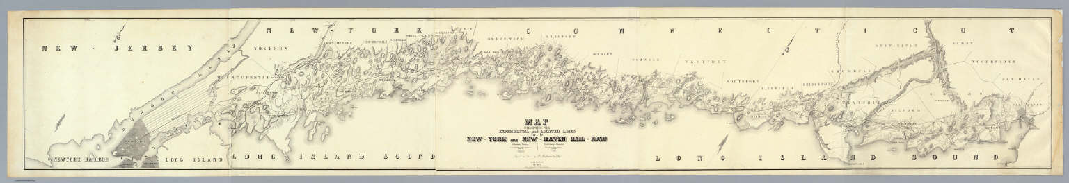
Full Title
Map Exhibiting The Experimental and Located Lines for the New-York and New-Haven Rail-Road ... Projected and Drawn by P. Anderson Civil Engr. Scale 1 to 40,000. Febr. 1845. Snyder & Black Lithogrs. 87 Fulton St. New-York.
List No
4218.000
Note
Greatly detailed strip map over ten feet long showing the surveyed routes of the New York and New Haven Railroad. The line was opened in 1849. The map is unique for a railroad map in its huge size, large scale, elegance of drawing, and variety of information shown (houses, trails, rivers, turnpikes, lighthouses, harbors, hills, swamps, etc.).
Author
Tanner, Henry S.
Full Title
Map Of The State Of New York With the Latest Improvements. Showing All The Canals & Railroads, & c. 1845. (to accompany) The Traveller's Hand Book for the State of New York, The Province of Canada, and Parts of the Adjoining States ... By Which Every Interesting Object on the Leading Routes is Brought into View. With Maps, Etc. Third Edition. By H.S. Tanner. New York: Published at the Geographical Establishment ... 1845. (on verso) Entered ... 1843, by H.S. Tanner ... New York.
List No
2036.003
Note
The New York State map, in full color, has the maker's name erased from the plate below the neat line; it appears to be a litho copy, updated, of Finley's 1826 American Atlas map of New York State. Includes 2 inset maps of City of New York and City of Albany. Also showing the length of Rivers and Comparative Heights of Mountains. Prime meridian is Philadelphia. Bound with blue cloth covers and title embossed on front.
Author
[Breese, Samuel, 1802-1873, Morse, Sidney E. (Sidney Edwards), 1794-1871]
Full Title
Maryland and Delaware. (with) District of Columbia. (By Sidney E. Morse and Samuel Breese. New York: Published by Harper & Brothers, 1845)
List No
2301.017
Note
Col. wax engraved map. Relief shown by hachures. Includes profiles of the Baltimore and Ohio Canal and Baltimore and Ohio Railroad. Prime meridians: Greenwich and Washington.
Author
Meyer, Joseph, 1796-1856
Full Title
Neueste Karte von Pennsylvania mit seinen Canaelen, Eisenbahnen &c. Nach den bessten Quellen bearbeitet. 1845. (with) Profil des Pennsylvania Canals, Columbia Eisenbahn. Aus der Geographischen Graviranstalt des Bibliographischen Instituts zu Hildburghausen, Amsterdam, Paris u. Philadelphia, (1860)
List No
4807.143
Note
Engraved map. State boundaries hand col. Relief shown by hachures. Includes distance tables. "Meyer's Handatlas No. 57." Prime meridians: Ferro and Washington.
Author
[Morse, Sidney E. (Sidney Edwards), 1794-1871, Breese, Samuel]
Full Title
Maryland and Delaware. (inset) District of Columbia. (By Sidney E. Morse and Samuel Breese. New York: Published by Harper & Brothers, 1845). (to accompany) Morse's Cerographic Maps. No. VIII.
List No
4861.065
Note
Color wax engraved map. Shows capitals, towns, road, railroads, rivers, canals, etc. Includes explanation and profiles of the Baltimore and Ohio Canal and Baltimore and Ohio Railroad. Relief shown by hachures. Prime meridians are Greenwich and Washington.
1-6 of 6
|