|
REFINE
Browse All : Railroad and World Atlas of Great Britain
1-9 of 9
Author
شكوفه مقبل [Şukufe Mukbil]
Full Title
(Great Britain and Ireland)
List No
10992.013
Note
Dimensions are sheet size.
Author
[Martin, R.M., Tallis, J. & F.]
Full Title
Talis's Railway Map of Great Britain. Showing the Railways Completed, and the Stations on each line, up to the present time.
List No
10095.088
Author
[Wyld, James, 1812-1887, Wyld, James, 1790-1836]
Full Title
Map of the United Kingdom of Great Britain and Ireland. By James Wyld. London. Published by James Wyld. (to accompany) A new general atlas of modern geography : consisting of a complete collection of maps of the four quarters of the globe ...
List No
13170.011
Note
Engraved map, hand colored in outline. Inset: Shetland Is. Includes statistical table. Covering all of England, Scotland, Ireland, and Wale. Showing political and administrative boundaries, railroads, towns and cities. Relief is shown by hachures.
Author
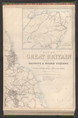
[Weekly Dispatch, Weller, Edward, 1819-1884]
Full Title
Railway map of Great Britain : Showing all the railways, & railway stations, the canals, navigable rivers, & principal roads : (North east sheet) / by Edwd. Weller, F. R. G. S. ; engraved by Edwd. Weller, 34 Red Lion Square ; E. Weller Lithogr.
List No
14360.121
Note
Map of Great Britain, featuring railways and stations, canals, navigable rivers and roads (northeast sheet). Shows political boundaries, cities, railways, roads, canals, coal fields, bodies of water, drainage, coastlines, shoals and islands. Includes latitudinal and longitudinal lines, as well as a legend and bar scale given in British miles. With inset map: Continuation of Scotland. Hand-colored lithograph. Map is 65 x 46 cm, on double sheet 69 x 48 cm. Plate number handwritten in ink at lower left corner of sheet. Followed by maps entitled "(North west sheet) -- (South east sheet) -- (South west sheet)" on subsequent plates. Appears in Vol. I : British.
Author
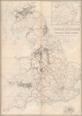
[Weekly Dispatch, Weller, Edward, 1819-1884]
Full Title
Railway map of Great Britain : Showing all the railways, & railway stations, the canals, navigable rivers, & principal roads : (North west sheet) / by Edwd. Weller, F. R. G. S. ; engraved by Edwd. Weller, 34 Red Lion Square ; E. Weller Lithogr.
List No
14360.122
Note
Map of Great Britain, featuring railways and stations, canals, navigable rivers and roads (northwest sheet). Shows political boundaries, cities, railways, roads, canals, coal fields, bodies of water, drainage, coastlines, shoals and islands. Includes latitudinal and longitudinal lines. Hand-colored lithograph. Map is 65 x 46 cm, on double sheet 69 x 48 cm. Plate number handwritten in ink at lower left corner of sheet. Preceded by map entitled "(North west sheet)" on previous plate; followed by "(South east sheet) -- (South west sheet)" on subsequent plates. Appears in Vol. I : British.
Author
[Weekly Dispatch, Weller, Edward, 1819-1884]
Full Title
Railway map of Great Britain : Showing all the railways, & railway stations, the canals, navigable rivers, & principal roads : (South east sheet) / by Edwd. Weller, F. R. G. S. ; engraved by Edwd. Weller, 34 Red Lion Square ; E. Weller Lithogr.
List No
14360.123
Note
Map of Great Britain, featuring railways and stations, canals, navigable rivers and roads (southeast sheet). Shows political boundaries, cities, railways, roads, canals, coal fields, bodies of water, drainage, coastlines, shoals and islands. Includes latitudinal and longitudinal lines. With inset map: Railways in the vicinity of London. Hand-colored lithograph. Map is 65 x 46 cm, on double sheet 69 x 48 cm. Plate number handwritten in ink at lower left corner of sheet. Preceded by maps entitled "(North west sheet) -- (North west sheet)" on previous plates; followed by "(South west sheet)" on subsequent plate. Appears in Vol. I : British.
Author
[Weekly Dispatch, Weller, Edward, 1819-1884]
Full Title
Railway map of Great Britain : Showing all the railways, & railway stations, the canals, navigable rivers, & principal roads : (South west sheet) / by Edwd. Weller, F. R. G. S. ; engraved by Edwd. Weller, 34 Red Lion Square ; E. Weller Lithogr.
List No
14360.124
Note
Map of Great Britain, featuring railways and stations, canals, navigable rivers and roads (southwest sheet). Shows political boundaries, cities, railways, roads, canals, coal fields, bodies of water, drainage, coastlines, shoals and islands. Includes latitudinal and longitudinal lines. Hand-colored lithograph. Map is 65 x 46 cm, on double sheet 69 x 48 cm. Plate number handwritten in ink at lower left corner of sheet. Preceded by maps entitled "(North west sheet) -- (North west sheet) -- (South east sheet)" on previous plates. Appears in Vol. I : British.
Author
[Weekly Dispatch, Weller, Edward, 1819-1884]
Full Title
(Composite Map to) Railway map of Great Britain : Showing all the railways, & railway stations, the canals, navigable rivers, & principal roads : (North east sheet) -- (North west sheet) -- (South east sheet) -- (South west sheet) / by Edwd. Weller, F. R. G. S. ; engraved by Edwd. Weller, 34 Red Lion Square ; E. Weller Lithogr.
List No
14360.125
Note
Composite map of Great Britain, featuring railways and stations, canals, navigable rivers and roads (northeast, northwest, southeast and southwest sheets). Shows political boundaries, cities, railways, roads, canals, coal fields, bodies of water, drainage, coastlines, shoals and islands. Includes latitudinal and longitudinal lines, as well as a legend and bar scale given in British miles. With two inset maps: Continuation of Scotland -- Railways in the vicinity of London. Hand-colored lithograph. Map is 130 x 92 cm, on four double sheets, together 138 x 96 cm. Sheets presented in sequence. Appears in Vol. I : British.
Author
Fullarton, A. & Co.
Full Title
Railway Map of the British Isles exhibiting all the railways & canals in England, Scotland & Ireland completed or in progress with their respective stations. By J. Bartholomew Junr. Edinr. F.R.G.S. XXIV. (with) six inset maps: Enlarged Section of the South Yorkshire and Lancashire Districts; Railways Around London; Birmingham; Manchester; Edinburgh; Glasgow. Engraved by J. Bartholomew, Edinr. A. Fullarton & Co. Edinburgh, London & Dublin.
List No
3007.024
Note
In full color. Railways shown in red; railways under construction shown with dotted red lines. Lists included of references to railways in England, Scotland, and Ireland.
1-9 of 9
|