|
REFINE
Browse All : Railroad and Property Ownership
1-43 of 43
Author
[Atchison and Nebraska Railroad, Chicago, Burlington, and Quincy Railroad]
Full Title
Composite: 24 sheets. A. & N. R.R. (Plans for route of Atchison and Nebraska Railroad)
List No
10287.025
Note
A set of 24 hand-drawn and colored maps showing the route of the proposed Atchison and Nebraska Railroad in northern Kansas and southern Nebraska, just west of the Missouri River. Many annotations in pencil list the land owners of parcels the proposed railroad line goes through and the cost per acre under sale contract. There are also notes on sheet 8 on the Condemnation of land for an owner who will not sell. The line appears to have been built approximately according to the drawings although in some areas the route was changed - this is based on comparing the routes shown on the 1887 county maps. The set of maps provides a detailed record of how land was secured for the railroads and how the lines were surveyed. View in Google Earth https://rumsey3.s3.amazonaws.com/Atchison_and_Nebraska_Railroad_1872.kmz
Author
[Atchison and Nebraska Railroad, Chicago, Burlington, and Quincy Railroad]
Full Title
Composite: County maps of Richardson county in Nebraska, and Doniphan, Brown, and Atchison counties in Kansas.
List No
10287.026
Note
A set of 24 hand-drawn and colored maps showing the route of the proposed Atchison and Nebraska Railroad in northern Kansas and southern Nebraska, just west of the Missouri River. Many annotations in pencil list the land owners of parcels the proposed railroad line goes through and the cost per acre under sale contract. There are also notes on sheet 8 on the Condemnation of land for an owner who will not sell. The line appears to have been built approximately according to the drawings although in some areas the route was changed - this is based on comparing the routes shown on the 1887 county maps. The set of maps provides a detailed record of how land was secured for the railroads and how the lines were surveyed. View in Google Earth https://rumsey3.s3.amazonaws.com/Atchison_and_Nebraska_Railroad_1872.kmz
Author
[Atchison and Nebraska Railroad, Chicago, Burlington, and Quincy Railroad]
Full Title
Composite: 24 sheets. A. & N. R.R. (Plans for route of Atchison and Nebraska Railroad)
List No
10287.027
Note
A set of 24 hand-drawn and colored maps showing the route of the proposed Atchison and Nebraska Railroad in northern Kansas and southern Nebraska, just west of the Missouri River. Many annotations in pencil list the land owners of parcels the proposed railroad line goes through and the cost per acre under sale contract. There are also notes on sheet 8 on the Condemnation of land for an owner who will not sell. The line appears to have been built approximately according to the drawings although in some areas the route was changed - this is based on comparing the routes shown on the 1887 county maps. The set of maps provides a detailed record of how land was secured for the railroads and how the lines were surveyed. View in Google Earth https://rumsey3.s3.amazonaws.com/Atchison_and_Nebraska_Railroad_1872.kmz
Author
[Atchison and Nebraska Railroad, Chicago, Burlington, and Quincy Railroad]
Full Title
1. A. & N. R.R. (Plans for route of Atchison and Nebraska Railroad)
List No
10287.001
Note
A set of 24 hand-drawn and colored maps showing the route of the proposed Atchison and Nebraska Railroad in northern Kansas and southern Nebraska, just west of the Missouri River. Many annotations in pencil list the land owners of parcels the proposed railroad line goes through and the cost per acre under sale contract. There are also notes on sheet 8 on the Condemnation of land for an owner who will not sell. The line appears to have been built approximately according to the drawings although in some areas the route was changed - this is based on comparing the routes shown on the 1887 county maps. The set of maps provides a detailed record of how land was secured for the railroads and how the lines were surveyed. View in Google Earth https://rumsey3.s3.amazonaws.com/Atchison_and_Nebraska_Railroad_1872.kmz
Author
[Atchison and Nebraska Railroad, Chicago, Burlington, and Quincy Railroad]
Full Title
2. A. & N. R.R. (Plans for route of Atchison and Nebraska Railroad)
List No
10287.002
Note
A set of 24 hand-drawn and colored maps showing the route of the proposed Atchison and Nebraska Railroad in northern Kansas and southern Nebraska, just west of the Missouri River. Many annotations in pencil list the land owners of parcels the proposed railroad line goes through and the cost per acre under sale contract. There are also notes on sheet 8 on the Condemnation of land for an owner who will not sell. The line appears to have been built approximately according to the drawings although in some areas the route was changed - this is based on comparing the routes shown on the 1887 county maps. The set of maps provides a detailed record of how land was secured for the railroads and how the lines were surveyed. View in Google Earth https://rumsey3.s3.amazonaws.com/Atchison_and_Nebraska_Railroad_1872.kmz
Author
[Atchison and Nebraska Railroad, Chicago, Burlington, and Quincy Railroad]
Full Title
3. A. & N. R.R. (Plans for route of Atchison and Nebraska Railroad)
List No
10287.003
Note
A set of 24 hand-drawn and colored maps showing the route of the proposed Atchison and Nebraska Railroad in northern Kansas and southern Nebraska, just west of the Missouri River. Many annotations in pencil list the land owners of parcels the proposed railroad line goes through and the cost per acre under sale contract. There are also notes on sheet 8 on the Condemnation of land for an owner who will not sell. The line appears to have been built approximately according to the drawings although in some areas the route was changed - this is based on comparing the routes shown on the 1887 county maps. The set of maps provides a detailed record of how land was secured for the railroads and how the lines were surveyed. View in Google Earth https://rumsey3.s3.amazonaws.com/Atchison_and_Nebraska_Railroad_1872.kmz
Author
[Atchison and Nebraska Railroad, Chicago, Burlington, and Quincy Railroad]
Full Title
5. A. & N. R.R. (Plans for route of Atchison and Nebraska Railroad)
List No
10287.004
Note
A set of 24 hand-drawn and colored maps showing the route of the proposed Atchison and Nebraska Railroad in northern Kansas and southern Nebraska, just west of the Missouri River. Many annotations in pencil list the land owners of parcels the proposed railroad line goes through and the cost per acre under sale contract. There are also notes on sheet 8 on the Condemnation of land for an owner who will not sell. The line appears to have been built approximately according to the drawings although in some areas the route was changed - this is based on comparing the routes shown on the 1887 county maps. The set of maps provides a detailed record of how land was secured for the railroads and how the lines were surveyed. View in Google Earth https://rumsey3.s3.amazonaws.com/Atchison_and_Nebraska_Railroad_1872.kmz
Author
[Atchison and Nebraska Railroad, Chicago, Burlington, and Quincy Railroad]
Full Title
6. A. & N. R.R. (Plans for route of Atchison and Nebraska Railroad)
List No
10287.005
Note
A set of 24 hand-drawn and colored maps showing the route of the proposed Atchison and Nebraska Railroad in northern Kansas and southern Nebraska, just west of the Missouri River. Many annotations in pencil list the land owners of parcels the proposed railroad line goes through and the cost per acre under sale contract. There are also notes on sheet 8 on the Condemnation of land for an owner who will not sell. The line appears to have been built approximately according to the drawings although in some areas the route was changed - this is based on comparing the routes shown on the 1887 county maps. The set of maps provides a detailed record of how land was secured for the railroads and how the lines were surveyed. View in Google Earth https://rumsey3.s3.amazonaws.com/Atchison_and_Nebraska_Railroad_1872.kmz
Author
[Atchison and Nebraska Railroad, Chicago, Burlington, and Quincy Railroad]
Full Title
7. A. & N. R.R. (Plans for route of Atchison and Nebraska Railroad)
List No
10287.006
Note
A set of 24 hand-drawn and colored maps showing the route of the proposed Atchison and Nebraska Railroad in northern Kansas and southern Nebraska, just west of the Missouri River. Many annotations in pencil list the land owners of parcels the proposed railroad line goes through and the cost per acre under sale contract. There are also notes on sheet 8 on the Condemnation of land for an owner who will not sell. The line appears to have been built approximately according to the drawings although in some areas the route was changed - this is based on comparing the routes shown on the 1887 county maps. The set of maps provides a detailed record of how land was secured for the railroads and how the lines were surveyed. View in Google Earth https://rumsey3.s3.amazonaws.com/Atchison_and_Nebraska_Railroad_1872.kmz
Author
[Atchison and Nebraska Railroad, Chicago, Burlington, and Quincy Railroad]
Full Title
8. A. & N. R.R. (Plans for route of Atchison and Nebraska Railroad)
List No
10287.007
Note
A set of 24 hand-drawn and colored maps showing the route of the proposed Atchison and Nebraska Railroad in northern Kansas and southern Nebraska, just west of the Missouri River. Many annotations in pencil list the land owners of parcels the proposed railroad line goes through and the cost per acre under sale contract. There are also notes on sheet 8 on the Condemnation of land for an owner who will not sell. The line appears to have been built approximately according to the drawings although in some areas the route was changed - this is based on comparing the routes shown on the 1887 county maps. The set of maps provides a detailed record of how land was secured for the railroads and how the lines were surveyed. View in Google Earth https://rumsey3.s3.amazonaws.com/Atchison_and_Nebraska_Railroad_1872.kmz
Author
[Atchison and Nebraska Railroad, Chicago, Burlington, and Quincy Railroad]
Full Title
9. A. & N. R.R. (Plans for route of Atchison and Nebraska Railroad)
List No
10287.008
Note
A set of 24 hand-drawn and colored maps showing the route of the proposed Atchison and Nebraska Railroad in northern Kansas and southern Nebraska, just west of the Missouri River. Many annotations in pencil list the land owners of parcels the proposed railroad line goes through and the cost per acre under sale contract. There are also notes on sheet 8 on the Condemnation of land for an owner who will not sell. The line appears to have been built approximately according to the drawings although in some areas the route was changed - this is based on comparing the routes shown on the 1887 county maps. The set of maps provides a detailed record of how land was secured for the railroads and how the lines were surveyed. View in Google Earth https://rumsey3.s3.amazonaws.com/Atchison_and_Nebraska_Railroad_1872.kmz
Author
[Atchison and Nebraska Railroad, Chicago, Burlington, and Quincy Railroad]
Full Title
10. A. & N. R.R. (Plans for route of Atchison and Nebraska Railroad)
List No
10287.009
Note
A set of 24 hand-drawn and colored maps showing the route of the proposed Atchison and Nebraska Railroad in northern Kansas and southern Nebraska, just west of the Missouri River. Many annotations in pencil list the land owners of parcels the proposed railroad line goes through and the cost per acre under sale contract. There are also notes on sheet 8 on the Condemnation of land for an owner who will not sell. The line appears to have been built approximately according to the drawings although in some areas the route was changed - this is based on comparing the routes shown on the 1887 county maps. The set of maps provides a detailed record of how land was secured for the railroads and how the lines were surveyed. View in Google Earth https://rumsey3.s3.amazonaws.com/Atchison_and_Nebraska_Railroad_1872.kmz
Author
[Atchison and Nebraska Railroad, Chicago, Burlington, and Quincy Railroad]
Full Title
11. A. & N. R.R. (Plans for route of Atchison and Nebraska Railroad)
List No
10287.010
Note
A set of 24 hand-drawn and colored maps showing the route of the proposed Atchison and Nebraska Railroad in northern Kansas and southern Nebraska, just west of the Missouri River. Many annotations in pencil list the land owners of parcels the proposed railroad line goes through and the cost per acre under sale contract. There are also notes on sheet 8 on the Condemnation of land for an owner who will not sell. The line appears to have been built approximately according to the drawings although in some areas the route was changed - this is based on comparing the routes shown on the 1887 county maps. The set of maps provides a detailed record of how land was secured for the railroads and how the lines were surveyed. View in Google Earth https://rumsey3.s3.amazonaws.com/Atchison_and_Nebraska_Railroad_1872.kmz
Author
[Atchison and Nebraska Railroad, Chicago, Burlington, and Quincy Railroad]
Full Title
12. A. & N. R.R. (Plans for route of Atchison and Nebraska Railroad)
List No
10287.011
Note
A set of 24 hand-drawn and colored maps showing the route of the proposed Atchison and Nebraska Railroad in northern Kansas and southern Nebraska, just west of the Missouri River. Many annotations in pencil list the land owners of parcels the proposed railroad line goes through and the cost per acre under sale contract. There are also notes on sheet 8 on the Condemnation of land for an owner who will not sell. The line appears to have been built approximately according to the drawings although in some areas the route was changed - this is based on comparing the routes shown on the 1887 county maps. The set of maps provides a detailed record of how land was secured for the railroads and how the lines were surveyed. View in Google Earth https://rumsey3.s3.amazonaws.com/Atchison_and_Nebraska_Railroad_1872.kmz
Author
[Atchison and Nebraska Railroad, Chicago, Burlington, and Quincy Railroad]
Full Title
13. A. & N. R.R. (Plans for route of Atchison and Nebraska Railroad)
List No
10287.012
Note
A set of 24 hand-drawn and colored maps showing the route of the proposed Atchison and Nebraska Railroad in northern Kansas and southern Nebraska, just west of the Missouri River. Many annotations in pencil list the land owners of parcels the proposed railroad line goes through and the cost per acre under sale contract. There are also notes on sheet 8 on the Condemnation of land for an owner who will not sell. The line appears to have been built approximately according to the drawings although in some areas the route was changed - this is based on comparing the routes shown on the 1887 county maps. The set of maps provides a detailed record of how land was secured for the railroads and how the lines were surveyed. View in Google Earth https://rumsey3.s3.amazonaws.com/Atchison_and_Nebraska_Railroad_1872.kmz
Author
[Atchison and Nebraska Railroad, Chicago, Burlington, and Quincy Railroad]
Full Title
14. A. & N. R.R. (Plans for route of Atchison and Nebraska Railroad)
List No
10287.013
Note
A set of 24 hand-drawn and colored maps showing the route of the proposed Atchison and Nebraska Railroad in northern Kansas and southern Nebraska, just west of the Missouri River. Many annotations in pencil list the land owners of parcels the proposed railroad line goes through and the cost per acre under sale contract. There are also notes on sheet 8 on the Condemnation of land for an owner who will not sell. The line appears to have been built approximately according to the drawings although in some areas the route was changed - this is based on comparing the routes shown on the 1887 county maps. The set of maps provides a detailed record of how land was secured for the railroads and how the lines were surveyed. View in Google Earth https://rumsey3.s3.amazonaws.com/Atchison_and_Nebraska_Railroad_1872.kmz
Author
[Atchison and Nebraska Railroad, Chicago, Burlington, and Quincy Railroad]
Full Title
15. A. & N. R.R. (Plans for route of Atchison and Nebraska Railroad)
List No
10287.014
Note
A set of 24 hand-drawn and colored maps showing the route of the proposed Atchison and Nebraska Railroad in northern Kansas and southern Nebraska, just west of the Missouri River. Many annotations in pencil list the land owners of parcels the proposed railroad line goes through and the cost per acre under sale contract. There are also notes on sheet 8 on the Condemnation of land for an owner who will not sell. The line appears to have been built approximately according to the drawings although in some areas the route was changed - this is based on comparing the routes shown on the 1887 county maps. The set of maps provides a detailed record of how land was secured for the railroads and how the lines were surveyed. View in Google Earth https://rumsey3.s3.amazonaws.com/Atchison_and_Nebraska_Railroad_1872.kmz
Author
[Atchison and Nebraska Railroad, Chicago, Burlington, and Quincy Railroad]
Full Title
16. A. & N. R.R. (Plans for route of Atchison and Nebraska Railroad)
List No
10287.015
Note
A set of 24 hand-drawn and colored maps showing the route of the proposed Atchison and Nebraska Railroad in northern Kansas and southern Nebraska, just west of the Missouri River. Many annotations in pencil list the land owners of parcels the proposed railroad line goes through and the cost per acre under sale contract. There are also notes on sheet 8 on the Condemnation of land for an owner who will not sell. The line appears to have been built approximately according to the drawings although in some areas the route was changed - this is based on comparing the routes shown on the 1887 county maps. The set of maps provides a detailed record of how land was secured for the railroads and how the lines were surveyed. View in Google Earth https://rumsey3.s3.amazonaws.com/Atchison_and_Nebraska_Railroad_1872.kmz
Author
[Atchison and Nebraska Railroad, Chicago, Burlington, and Quincy Railroad]
Full Title
17. A. & N. R.R. (Plans for route of Atchison and Nebraska Railroad)
List No
10287.016
Note
A set of 24 hand-drawn and colored maps showing the route of the proposed Atchison and Nebraska Railroad in northern Kansas and southern Nebraska, just west of the Missouri River. Many annotations in pencil list the land owners of parcels the proposed railroad line goes through and the cost per acre under sale contract. There are also notes on sheet 8 on the Condemnation of land for an owner who will not sell. The line appears to have been built approximately according to the drawings although in some areas the route was changed - this is based on comparing the routes shown on the 1887 county maps. The set of maps provides a detailed record of how land was secured for the railroads and how the lines were surveyed. View in Google Earth https://rumsey3.s3.amazonaws.com/Atchison_and_Nebraska_Railroad_1872.kmz
Author
[Atchison and Nebraska Railroad, Chicago, Burlington, and Quincy Railroad]
Full Title
18. A. & N. R.R. (Plans for route of Atchison and Nebraska Railroad)
List No
10287.017
Note
A set of 24 hand-drawn and colored maps showing the route of the proposed Atchison and Nebraska Railroad in northern Kansas and southern Nebraska, just west of the Missouri River. Many annotations in pencil list the land owners of parcels the proposed railroad line goes through and the cost per acre under sale contract. There are also notes on sheet 8 on the Condemnation of land for an owner who will not sell. The line appears to have been built approximately according to the drawings although in some areas the route was changed - this is based on comparing the routes shown on the 1887 county maps. The set of maps provides a detailed record of how land was secured for the railroads and how the lines were surveyed. View in Google Earth https://rumsey3.s3.amazonaws.com/Atchison_and_Nebraska_Railroad_1872.kmz
Author
[Atchison and Nebraska Railroad, Chicago, Burlington, and Quincy Railroad]
Full Title
19. A. & N. R.R. (Plans for route of Atchison and Nebraska Railroad)
List No
10287.018
Note
A set of 24 hand-drawn and colored maps showing the route of the proposed Atchison and Nebraska Railroad in northern Kansas and southern Nebraska, just west of the Missouri River. Many annotations in pencil list the land owners of parcels the proposed railroad line goes through and the cost per acre under sale contract. There are also notes on sheet 8 on the Condemnation of land for an owner who will not sell. The line appears to have been built approximately according to the drawings although in some areas the route was changed - this is based on comparing the routes shown on the 1887 county maps. The set of maps provides a detailed record of how land was secured for the railroads and how the lines were surveyed. View in Google Earth https://rumsey3.s3.amazonaws.com/Atchison_and_Nebraska_Railroad_1872.kmz
Author
[Atchison and Nebraska Railroad, Chicago, Burlington, and Quincy Railroad]
Full Title
20. A. & N. R.R. (Plans for route of Atchison and Nebraska Railroad)
List No
10287.019
Note
A set of 24 hand-drawn and colored maps showing the route of the proposed Atchison and Nebraska Railroad in northern Kansas and southern Nebraska, just west of the Missouri River. Many annotations in pencil list the land owners of parcels the proposed railroad line goes through and the cost per acre under sale contract. There are also notes on sheet 8 on the Condemnation of land for an owner who will not sell. The line appears to have been built approximately according to the drawings although in some areas the route was changed - this is based on comparing the routes shown on the 1887 county maps. The set of maps provides a detailed record of how land was secured for the railroads and how the lines were surveyed. View in Google Earth https://rumsey3.s3.amazonaws.com/Atchison_and_Nebraska_Railroad_1872.kmz
Author
[Atchison and Nebraska Railroad, Chicago, Burlington, and Quincy Railroad]
Full Title
21. A. & N. R.R. (Plans for route of Atchison and Nebraska Railroad)
List No
10287.020
Note
A set of 24 hand-drawn and colored maps showing the route of the proposed Atchison and Nebraska Railroad in northern Kansas and southern Nebraska, just west of the Missouri River. Many annotations in pencil list the land owners of parcels the proposed railroad line goes through and the cost per acre under sale contract. There are also notes on sheet 8 on the Condemnation of land for an owner who will not sell. The line appears to have been built approximately according to the drawings although in some areas the route was changed - this is based on comparing the routes shown on the 1887 county maps. The set of maps provides a detailed record of how land was secured for the railroads and how the lines were surveyed. View in Google Earth https://rumsey3.s3.amazonaws.com/Atchison_and_Nebraska_Railroad_1872.kmz
Author
[Atchison and Nebraska Railroad, Chicago, Burlington, and Quincy Railroad]
Full Title
21a. A. & N. R.R. (Plans for route of Atchison and Nebraska Railroad)
List No
10287.021
Note
A set of 24 hand-drawn and colored maps showing the route of the proposed Atchison and Nebraska Railroad in northern Kansas and southern Nebraska, just west of the Missouri River. Many annotations in pencil list the land owners of parcels the proposed railroad line goes through and the cost per acre under sale contract. There are also notes on sheet 8 on the Condemnation of land for an owner who will not sell. The line appears to have been built approximately according to the drawings although in some areas the route was changed - this is based on comparing the routes shown on the 1887 county maps. The set of maps provides a detailed record of how land was secured for the railroads and how the lines were surveyed. View in Google Earth https://rumsey3.s3.amazonaws.com/Atchison_and_Nebraska_Railroad_1872.kmz
Author
[Atchison and Nebraska Railroad, Chicago, Burlington, and Quincy Railroad]
Full Title
27. A. & N. R.R. (Plans for route of Atchison and Nebraska Railroad)
List No
10287.022
Note
A set of 24 hand-drawn and colored maps showing the route of the proposed Atchison and Nebraska Railroad in northern Kansas and southern Nebraska, just west of the Missouri River. Many annotations in pencil list the land owners of parcels the proposed railroad line goes through and the cost per acre under sale contract. There are also notes on sheet 8 on the Condemnation of land for an owner who will not sell. The line appears to have been built approximately according to the drawings although in some areas the route was changed - this is based on comparing the routes shown on the 1887 county maps. The set of maps provides a detailed record of how land was secured for the railroads and how the lines were surveyed. View in Google Earth https://rumsey3.s3.amazonaws.com/Atchison_and_Nebraska_Railroad_1872.kmz
Author
[Atchison and Nebraska Railroad, Chicago, Burlington, and Quincy Railroad]
Full Title
28. A. & N. R.R. (Plans for route of Atchison and Nebraska Railroad)
List No
10287.023
Note
A set of 24 hand-drawn and colored maps showing the route of the proposed Atchison and Nebraska Railroad in northern Kansas and southern Nebraska, just west of the Missouri River. Many annotations in pencil list the land owners of parcels the proposed railroad line goes through and the cost per acre under sale contract. There are also notes on sheet 8 on the Condemnation of land for an owner who will not sell. The line appears to have been built approximately according to the drawings although in some areas the route was changed - this is based on comparing the routes shown on the 1887 county maps. The set of maps provides a detailed record of how land was secured for the railroads and how the lines were surveyed. View in Google Earth https://rumsey3.s3.amazonaws.com/Atchison_and_Nebraska_Railroad_1872.kmz
Author
[Atchison and Nebraska Railroad, Chicago, Burlington, and Quincy Railroad]
Full Title
29. A. & N. R.R. (Plans for route of Atchison and Nebraska Railroad)
List No
10287.024
Note
A set of 24 hand-drawn and colored maps showing the route of the proposed Atchison and Nebraska Railroad in northern Kansas and southern Nebraska, just west of the Missouri River. Many annotations in pencil list the land owners of parcels the proposed railroad line goes through and the cost per acre under sale contract. There are also notes on sheet 8 on the Condemnation of land for an owner who will not sell. The line appears to have been built approximately according to the drawings although in some areas the route was changed - this is based on comparing the routes shown on the 1887 county maps. The set of maps provides a detailed record of how land was secured for the railroads and how the lines were surveyed. View in Google Earth https://rumsey3.s3.amazonaws.com/Atchison_and_Nebraska_Railroad_1872.kmz
Author
Gray, Ormando Willis
Full Title
Map of Richmond, Henrico County, Virginia. (inset continuation of main map).
List No
3888.073
Note
Prime meridians Washington D.C. and Greenwich. Relief shown by hachures.
Author
Gray, Ormando Willis
Full Title
Edinburg, Shenandoah County, Virginia.
List No
3888.074
Note
Prime meridians Washington D.C. and Greenwich. Relief shown by hachures.
Author
Gray, Ormando Willis
Full Title
Woodstock, Shenandoah County, Virginia.
List No
3888.075
Note
Prime meridians Washington D.C. and Greenwich. Relief shown by hachures.
Author
Gray, Ormando Willis
Full Title
Mt. Jackson, Shenandoah County, Virginia. New Market, Shenandoah County, Virginia.
List No
3888.076
Note
Prime meridians Washington D.C. and Greenwich. Relief shown by hachures.
Author
Gray, Ormando Willis
Full Title
Gray's New Map of Lexington, Rockingham County, Virginia. Drawn from Special Surveys, 1877. Drawn, Engraved, and Published by O.W. Gray & Son, Geographers, Manufacturers of Maps and Atlases, 10 North Fifth Street, Philadelphia. Jacob Chace, Topographical Engineer, Manager of Local Surveys.
List No
3888.077
Note
Prime meridians Washington D.C. and Greenwich. Relief shown by hachures.
Author
Gray, Ormando Willis
Full Title
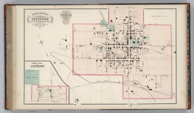
Gray's New Map of Leesburg, Loudoun Co., Virginia. Drawn from Special Surveys, 1878. Drawn, Engraved, and Published by O.W. Gray & Son, Geographers, Manufacturers of Maps and Atlases, 10 North Fifth Street, Philadelphia. Jacob Chace, Topographical Engineer, Manager of Local Surveys. George Chace, Assistant Engineer. (inset a continuation of main map).
List No
3888.080
Note
Prime meridians Washington D.C. and Greenwich. Relief shown by hachures.
Author
Gray, Ormando Willis
Full Title
Strasburg, Shenandoah County, Virginia.
List No
3888.081
Note
Prime meridians Washington D.C. and Greenwich. Relief shown by hachures.
Author
Gray, Ormando Willis
Full Title
Gray's New Map of Charlottesville, Albemarle County, Virginia. Drawn from Special Surveys, 1877. Drawn, Engraved, and Published by O.W. Gray & Son, Geographers, Manufacturers of Maps and Atlases, 10 North Fifth Street, Philadelphia. Jacob Chace, Topographical Engineer, Manager of Local Surveys. (inset) (Vicinity of) Charlottesville.
List No
3888.082
Author
Gray, Ormando Willis
Full Title
Map of Orange Court House, Orange County, Virginia. Philadelphia: O.W. Gray & Son.
List No
3888.083
Author
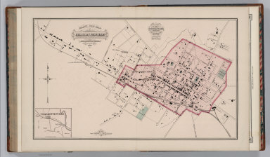
Gray, Ormando Willis
Full Title
Gray's New Map of Culpepper, Culpepper County, Virginia. Drawn from Special Surveys, 1878. Drawn, Engraved, and Published by O.W. Gray & Son, Geographers, Manufacturers of Maps and Atlases, 10 North Fifth Street, Philadelphia. Jacob Chace, Topographical Engineer, Manager of Local Surveys. George Chace, Assistant Engineer.
List No
3888.084
Note
Prime meridians Washington D.C. and Greenwich. Relief shown by hachures. Full color.
Author
Gray, Ormando Willis
Full Title
Gray's New Map of Gordonsville, Orange County, Virginia. Drawn from Special Surveys, 1878. Philadelphia: O.W. Gray & Son. Gray's New Map of Harrisonburg (Outline), Rockingham County, Virginia. Drawn from Special Surveys, 1877. Philadelphia: O.W. Gray & Son.
List No
3888.085
Note
Prime meridians Washington D.C. and Greenwich. Relief shown by hachures. Full color.
Author
Gray, Ormando Willis
Full Title
Gray's New Map of Harrisonburg, Rockingham Co., Virginia. Drawn from Special Surveys, 1877. Drawn, Engraved, and Published by O.W. Gray & Son, Geographers, Manufacturers of Maps and Atlases, 10 North Fifth Street, Philadelphia. Jacob Chace, Topographical Engineer, Manager of Local Surveys.
List No
3888.086
Note
Prime meridians Washington D.C. and Greenwich. Relief shown by hachures. Full color.
Author
Gray, Ormando Willis
Full Title
Gray's New Map of Bridgewater, Rockingham County, Virginia. Drawn from Special Surveys, 1877. Philadelphia: O.W. Gray & Son.
List No
3888.087
Note
Prime meridians Washington D.C. and Greenwich. Relief shown by hachures. Full color.
Author
Caldwell, Joseph A.
Full Title
Railway Map of the State of Pennsylvania. J.A. Caldwell. 1876. Engraved & printed by Otto Krebs, Pittsburg, Pa. Entered ... 1876 by J.A. Caldwell ... Washington. (to accompany) Caldwell's Illustrated, Historical, Centennial Atlas Of Beaver County, Pennsylvania. From actual Surveys by & under the directions of J.A. Caldwell. Assisted by C.T. Arms, Sr. C.E. J.A. Underwood, C.E. J.A. Howden. P.L. Mason. W.J. Kerstetter, C.E. W.F. Arms, C.E. J.J. Power, C.E. Published By J.A. Caldwell, Condit, Ohio. 1876. Engraved, Lithographed & Printed By Otto Krebs, Pittsburgh, Pa.
List No
5043.016
Note
Full colored map by counties. Shows railroads, roads, cities and townships.
Author
Caldwell, Joseph A.
Full Title
Map of the Pittsburgh, Cincinnati and St. Louis R.R. Pan Handle Route and Principal Connections. Rand Mcnally & Co., Engraver, Chicago. Printed under Patent of January 12, 1875. ( (to accompany) Caldwell's Illustrated, Historical, Centennial Atlas Of Beaver County, Pennsylvania. From actual Surveys by & under the directions of J.A. Caldwell. Assisted by C.T. Arms, Sr. C.E. J.A. Underwood, C.E. J.A. Howden. P.L. Mason. W.J. Kerstetter, C.E. W.F. Arms, C.E. J.J. Power, C.E. Published By J.A. Caldwell, Condit, Ohio. 1876. Engraved, Lithographed & Printed By Otto Krebs, Pittsburgh, Pa.
List No
5043.067
Note
Full color map of the Northeastern United States, showing cities and towns, and the railroad network with named lines. Emphasis on the main lines. Relief shown by hachures.
Author
Caldwell, Joseph A.
Full Title
(Advertisement to) The Great Pan Handle Route. D.W. Caldwell, General Manage, Columbus, Ohio. W.L. O"Brian, General Passenger and Ticket Agent, Columbus, Ohio. ( (to accompany) Caldwell's Illustrated, Historical, Centennial Atlas Of Beaver County, Pennsylvania. From actual Surveys by & under the directions of J.A. Caldwell. Assisted by C.T. Arms, Sr. C.E. J.A. Underwood, C.E. J.A. Howden. P.L. Mason. W.J. Kerstetter, C.E. W.F. Arms, C.E. J.J. Power, C.E. Published By J.A. Caldwell, Condit, Ohio. 1876. Engraved, Lithographed & Printed By Otto Krebs, Pittsburgh, Pa.
List No
5043.068
Note
full page advertisement for "The great Pan Handle Route." Provides the featured routes, connecting North, South, East and West.
1-43 of 43
|